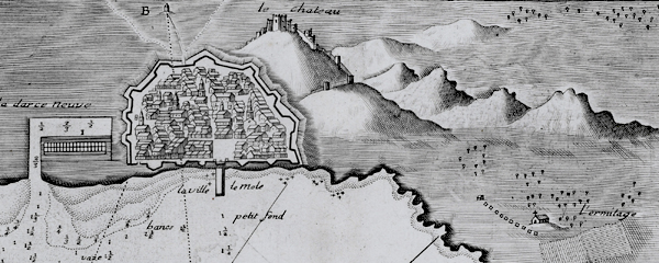
DESCRIPTION: Fine nautical chart or plan of the town and harbor of Cartagena, Spain by Jacques Ayrouard (Marseilles ca. 1732- 1746). Original copperplate engraving shows the town of Cartagena surrounded by defensive walls, and unusually for 18th century charts/plans shows the adjacent topography in great detail. Noted features include l'Hermitage", "le Chateau", "pointe du fort", and "pointe galere" near a "chapelle".
 View of Cartagena, Spain by Ayrouard, 1746. View of Cartagena, Spain by Ayrouard, 1746.
Sourced from Ayrouard's scarce sea atlas: "Recueil de Plusiers Plans des Ports et Rades et de Quelque Cartes Particulieres de la Mer Méditerranée." Beautifully engraved by Louis Corne.
Ayrouard was a pilot of the French royal galley, the Reale, based in Marseille, France. The much larger size (18"x11") and extensively shaded topography in this plan are distinctive characteristics of Ayrouard's nautical port plans. Plate 68.
PUBLICATION DATE: 1746
GEOGRAPHIC AREA: Spain
BODY OF WATER: Mediterranean
CONDITION: Very good.
Slight offsetting. Bright and clean with no defects. Acceptable margins all around.
COLORING: None
ENGRAVER: Louis Corne
SIZE: 18
" x
11 "
ITEM PHYSICAL LOCATION: 8
PRICE: $375
ADD TO CART

|