DESCRIPTION: Beautiful, antique plan and chart of the Tagus River, Lisbon, Portugal and surrounding area. At the top the entire width of this scarce nautical chart contains a detailed panoramic profile view of Lisbon ( Lisbonne ) westward past Belem as it existed in the mid-eighteenth century with the core city surrounded by walls. Would make a fine gift for anyone with an interest in boating or other maritime activities in the area of Lisbon, Portugal.
At that time the size of the city was much smaller than today- Belem ( Bourg de Belem ) and the Tower of Belém ( Tour de Belem ) are far outside the city walls. An inset plan below the decorative title cartouche shows detailed information about Lisbon and an explanatory legend. These important feature include : le Chateau; la Palais du Roy; the customs house- la Douane; and a major shipyard - Chantier pour la construction des Vaisseaux. Coverage includes several areas that are popular today with tourists including Sintra ( Cintra ), and Cascais, on the Atlantic coast near Cabo de la Roca.
Numerous geographical and topographical features including: Setubal, Colares, Fort St. Antoine, Fort de St. Julien, Village de Passe d'Arc', the convent of Notre Dame de Bon Voyages, Sacaven, Port Brandan, Fort de Bougie, Romeira, Cap Spichel, Sezimbre, and Fort St. Philippe.
With rhumb lines and an attractive compass rose with an adjustment for magnetic variation. As expected on a sea chart there are numerous soundings, anchorages, and hazards including several long reefs off the mouth of the Tagus River. Published by J.N. Bellin for France's Depot de La Marine.
Jacques-Nicolas Bellin (1703-1772)
Jacques-Nicolas Bellin was a prominent French hydrographer and geographer, recognized for his significant contributions to the development of cartography. For over half a century, Bellin served as the first Ingénieur de la Marine of the Depot des cartes et plans de la Marine (the French Hydrographic Office) and was appointed Official Hydrographer to the French King. His expertise and precision led to the production of thousands of significant nautical charts and maps, enhancing maritime navigation.
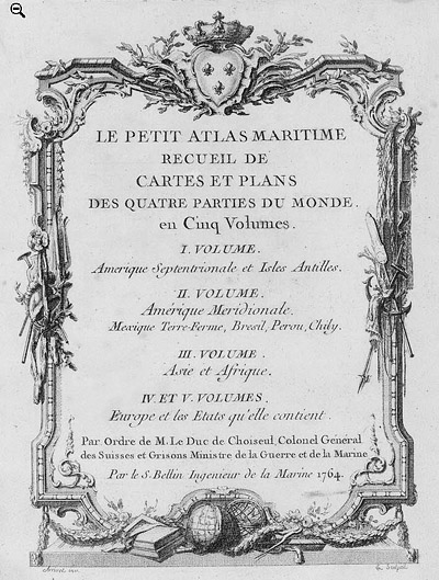 Petit Atlas Maritime Title Page, 1764 Petit Atlas Maritime Title Page, 1764
One of Bellin's most notable works, "Le Petit Atlas Maritime," was published in 1764, encompassing five volumes of detailed charts and maps covering every part of the world. Bellin's cartographic legacy extends beyond France; his comprehensive maps and atlases were highly influential in shaping European understanding of global geography during the 18th century. His passion for accuracy and vast output have ensured his place in the annals of cartographic history.
PUBLICATION DATE: 1756
GEOGRAPHIC AREA: Portugal
BODY OF WATER: Tagus River
CONDITION: Very good.
Very attractive with clean bright coloring. On heavy chain-laid paper. A bit of creasing in the margins at the bottom centerfold that will be hidden when matted. Very wide margins.
COLORING: Attractive old hand-coloring.
ENGRAVER:
SIZE: 25
" x
18 "
ITEM PHYSICAL LOCATION: 57
PRICE: $1600
ADD TO CART

|