DESCRIPTION: Increasingly scarce map of the world by Herman Moll ca. 1715 covering a large area from 50 degrees north to 50 degrees south of the Equator. The map, on Mercator's projection is centered on "the Great South Sea", or Pacific Ocean, and Moll's incomplete outlines for New Zealand, Australia, and Tasmania reflect the uncertain state of geographical knowledge in the early eighteenth century.
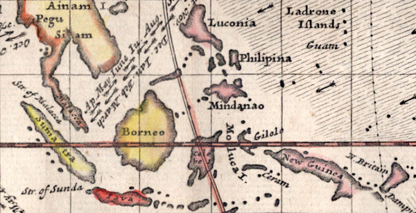
Moll's maps touching on compass variation and wind patterns, especially the trade winds, stand out as significant contributions to cartography and navigation. Moll tried to visualize the concept of global atmospheric circulation, making use of the contemporary understanding of trade winds and monsoons. Monsoon winds are seasonal wind patterns that occur over various regions, most notably in South and Southeast Asia, where they cause the well-known monsoon rains. As Moll explains in his note at upper left:
"Note that the Arrows among the Lines shew the Course of these General & Coasting Winds, and the Arrows in the void Spaces shew the Course of the Shifting TRADE-WINDS, and the abbreviations Sept. &c. Shew the Times of the Year when such Winds blow".
 Monsoon and Trade Winds in The East Indies. Moll, 1715. Monsoon and Trade Winds in The East Indies. Moll, 1715.
On this map, Moll represented the trade winds – the predictable east-west wind patterns in the tropical latitudes – using arrows. Knowing the direction of the trade winds at specific times of the year, was crucial to understanding how to plan routes for ships involved in trade and exploration. This information was invaluable to the burgeoning Atlantic economies, particularly in the context of the Atlantic triangular trade.
Herman Moll (circa 1654-1732)
Herman Moll distinguished himself as an eminent cartographer, engraver, and publisher, gaining substantial recognition for his work during the latter part of the 17th and the early 18th centuries. Originally based in London, Moll began his profession as an engraver, producing work as early as the 1670s. It wasn't long before he expanded his repertoire to include cartography and map publishing, often collaborating with renowned cartographers and publishers of his time.
With the dawn of the 18th century, Moll's career took off. His cartographic portfolio was impressively varied, spanning maps of England and the British Isles, the American colonies, Africa, the entire world, and even the solar system. Among his most distinguished works are "The World Described," an anthology of 30 individual maps published in a variety of editions between 1715 and 1753, and the large-scale "Atlas Geographus," which was published in monthly installments from 1708 to 1717.
One of the characteristic traits of Moll's maps lies in their elaborate cartouches, or decorative map titles, and the comprehensive textual commentary they included. His maps often bore a reflection of Britain's geopolitical and colonial interests during that era, drawing attention to regions of significant commercial and strategic value.
Beyond his contributions as a cartographer, Moll also played an active role in the intellectual circles of early 18th-century London. He maintained associations with prominent individuals of his time, including the famed writer Jonathan Swift and the notorious pirate William Dampier.
PUBLICATION DATE: 1715
GEOGRAPHIC AREA: World
BODY OF WATER: All
CONDITION: Good.
Short right margin. On laid paper with no holes, tears, or restorations. Traces of old adhesive at edges of margin as shown. Washed and flattened.
COLORING: Original hand coloring.
ENGRAVER: Moll
SIZE: 20
" x
7 "
ITEM PHYSICAL LOCATION: 89
PRICE: $400
ADD TO CART

|