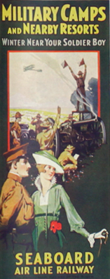
DESCRIPTION: Rare patriotic WWI map titled "Military Camps and Nearby Resorts. Winter Near Your Soldier Boy." This fine 31 inch long antique map was published by Seaboard Airline Railway in 1917. Outstanding and emotionally evocative graphics on the cover with a fine thematic promotional map on the recto.
 Military Resorts Cover Art Military Resorts Cover Art
Only one holding is found in WorldCat, at Rutgers. WorldCat's mildly cynical one-line summary of the map reads "War as a tourist industry for elegant ladies & gentlemen." (1)
This full-size folding map shows twenty-eight locations (Army, Navy, and Aero training camps) served by the Seaboard Air Line Railway where a spouse (wife) could travel to spend the winter holidays with her soldier (husband) during 1917, the fourth year of WWI. The camps and stations of the U.S. Army were indicated with red square symbols, those of the Navy with circles, and Aero Stations by triangles. The U.S. Army Air Service, as it was then called, was established after April, 1917 making this map one of the earliest available maps to show Pensacola as an Naval Air Training Station.
These Army, Navy, and Aero training locations, described in the key at bottom right, include Pensacola, Tampa, and Key West, Florida; New Orleans, Louisiana; Charleston, South Carolina; and Port Royal, SC.
Brochure folds to 4" x 9". Printed by Poole Brothers, Chicago and dated within at 8/16/1917.
(1) WorldCat. Online. Accessed: January, 2023
PUBLICATION DATE: 1917
GEOGRAPHIC AREA: United States
BODY OF WATER: Atlantic Ocean
CONDITION: Good.
Folds. A few splits at folds repaired from the verso. Small thin 1" loss at bottom center Grand Cayman Islands.
COLORING: Litho color.
ENGRAVER:
SIZE: 9
" x
31 "
ITEM PHYSICAL LOCATION: 150
PRICE: $800
ADD TO CART

|