The royal galley pilot:
rare coastal charts and port plans of Henry Michelot.
[IN STOCK: Henry Michelot and Laurens Bremond]
Three nations successively lead the world in cartographic innovation from the mid-sixteenth to
the mid-nineteenth century. These periods of national ascendency in mapping began for each
nation roughly at the same time as that nation was experiencing strong economic growth and
military development. First the Dutch, then the French and finally the English each made
substantial contributions to the cartographic body of knowledge, experienced growth in the number
and quality of trained practitioners and developed cartographic institutions that served to
ensure the quality and consistency of output.
France: "King of Cartography"
The period of cartographic ascendancy in France roughly dates to the period between
1660 to 1770 an era that C.M. Petto refers to as the period: "When France was King of Cartography".
Among the factors leading to this leadership position were the requests by Minister Colbert for
maps and charts to support offensive and defensive military operations, commercial interests,
and governmental decision-making. [1]
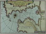
Shown above left IN STOCK: Plan du Port Vendre en Rousillon. Michelot and Bremond. 1727.
The lives and contribution of several early French map-makers have been written
about extensively, particularly those whose work is associated with French
cartographic/hydrographic institutions
such as the Depot de la Marine. The lives and work of Jacques-Nicolas Bellin and
Beautemps-Beaupre for example have been reasonably
well documented. This brief article will not address these or other better known cartographers
but will focus on Henry Michelot, a French navigator born in the mid 17th century whose works on the Mediterranean were created during France’s
cartographic florescence and were used at sea by navigators for at least 135 years.
The Galley Pilot
In the early 18th century Henry Michelot and Laurens Bremond published two important atlases of
Mediterranean sea charts and port plans that were widely relied upon by coastal navigators.
These atlases were predated by twenty to thirty years by a set of sailing directions written by
Michelot and by two small-scale charts of the Mediterranean produced by Michelot and Nicolas Therin.
Copies of several of their port plans (Cadiz, Gibraltar) were copied (and attributed) by
Thomas Kitchin and by Roux (unattributed) into the 1760’s. Michelot’s sailing directions
were published as late as 1825.
Charts by Michelot and Bremond are interesting and important because of the background of
their creators (Michelot, unlike later ‘cabinet geographers’ such as Bellin had long, first-hand experience at sea),
because of the iconography used in the title cartouches, and because of the influence of other
historical events that occurred during the period when the charts were produced and used. We will have to leave discussion of these events until a later time but they include the great plague
that swept Marseilles in 1720, the reign of Louis XIV from 1643 through 1715, and the growth
and decline of the French galley service, the last large fleet of oared fighting vessels, which grew to more than 55 vessels during
the reign of Louis XIV and was eliminated in 1748. [2]
Michelot and Therin
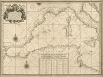
The first works we find attributed to Henry Michelot date from the late 17th century.
These works found at the Bibliotheque nationale de France consist of two folio-sized small-scale charts of the Eastern and the
Western Mediterranean [3]
produced in 1689-90 with Nicolas Therin and engraved by Claude Randon.
 Like Michelot's later works these charts were produced in Marseilles, at that time the headquarters of Louis XIV's Corp des Galeres (galères),
a group of about 40 oar and sail powered galleys (galères). The galley corps at that time was separate from and
sometimes in conflict with the regular French Navy whose headquarters were in Toulon.
Although these early charts are both dedicated to his patron the Chevalier de Noailles,
General of the French galleys, Michelot's name lacks any of the honorifics that later charts would display,
probably reflecting a relatively early stage in Michelot's career.
(See IN STOCK: Chatelain’s "Carte Generalle du Gouvernement Militaire de France "
for a unique historical snapshot of France's armed forces in 1695 including both the sailing navy and the galley forces.)
Like Michelot's later works these charts were produced in Marseilles, at that time the headquarters of Louis XIV's Corp des Galeres (galères),
a group of about 40 oar and sail powered galleys (galères). The galley corps at that time was separate from and
sometimes in conflict with the regular French Navy whose headquarters were in Toulon.
Although these early charts are both dedicated to his patron the Chevalier de Noailles,
General of the French galleys, Michelot's name lacks any of the honorifics that later charts would display,
probably reflecting a relatively early stage in Michelot's career.
(See IN STOCK: Chatelain’s "Carte Generalle du Gouvernement Militaire de France "
for a unique historical snapshot of France's armed forces in 1695 including both the sailing navy and the galley forces.)
These two portolan-style plane charts were decorated with large title cartouches depicting two sea gods
bearing clubs astride cornucopia supporting the royal crown. It is interesting that Michelot's early
work contains just a hint of the martial theme that is used on his charts 30 to 40 years later.
Consistent with the portolan style the charts contain numerous compass roses with radiating rhumb lines,
the coasts are thickly covered with names of ports, and no details whatsoever are provided of the interior geography.
Manuscript Port Plans
Our next encounter with Michelot's works consists of a set of manuscript medium-scale port plans of Italian and Tunisian ports.
Several plates from this 1699 work are catalogued in the Bibliotheque nationale de France including the hand colored
Plan de la Ville et Rade de Palerme et Selle, de Mondelle.
In this carefully drawn and annotated chart, possibly intended for sale
as part of a manuscript port atlas, we find that Michelot now refers to himself as "Pilote Ponantois" which could be translated
either as ‘Ocean Pilot" or perhaps as ‘Pilot for the Western Fleet’.
There are many similarities between Michelot's manuscript plans and the port plans published almost 30 years later by Michelot and Bremond.
For example for volcanoes on the 1699 chart of the Isle de Vulcan and the
1727 folio-sized chart of the Bay of Naples, both use similar imagery of a noticeably erupting, flaming volcano
(Gouffre and Vesu) and describe the scene with the same term- "Brulle Continuellement".
Despite these similarities for the one chart where this author was able to compare a 1699 manuscript
version to the later quarto-sized copperplate version printed 30 years later (Plan de la Ville et Rade de Melasse", it is
clear that the later plate is not at a mere copy. Not only has the chart orientation changed but there are significant changes
in topography and hydrography, suggesting that the charts were updated at some point after 1699.
Portulan Sailing Directions
In 1703 Pierre Mesnier published at Marseille the first edition of Henry Michelot's "Le Portulan de Partie de la Mer Méditerranée, ou Le vray Guide des Pilotes Costiers",
a book of sailing directions later re-published to a wider audience by Pierre Mortier in 1709. This volume proved popular;
an English translation was published by Thomas Corbett in 1715. It is from
Corbett’s" translation of Michelot’s preface to the pilot guide that we learn
Michelot’s birthplace was the French seaport of St. Malo, on the western approach to the English Channel and that
Michelot claimed already to have served as a pilot aboard the French galleys for 30 years.
In the ‘Portulan’ Michelot provides written descriptions of coastal geographic features, hydrographic soundings,
navigational aids, and courses to steer between waypoints… and a small dose of negative marketing.
Michelot draws attention to the shortcomings of other competing navigational sources, in particular the ‘Mirrors and Flambeau’
(Sea Atlases) and establishes his own work as the authoritative source, based on his many years first-hand experience at sea.
Other editions of the Portulan in the original French were produced at least through 1825 including this
1805 expanded edition (IN STOCK)
published by Jean Mossy at Marseille titled "Portulan de la mer Mediterranee ou Guide de Pilotes Costiers".
Small-scale Charts
Later Michelot seems to have been able to capitalize on his success selling the sailing directions as he joined with
Laurens Bremond to publish two nautical atlases. The first atlas produced chronologically usually contains 16 folio-sized
small-scale charts of the Mediterranean and of the Atlantic coast in proximity to the Strait of Gibraltar perhaps accompanied
with one or more profile views of vessels. Published dates for charts in this work range from 1718 to 1727.
By this date Michelot describes himself as "Hydrographe et Pilote Real des Galères du Roy"
(hydrographer and pilot of the royal galley for the kings galley corps).
Little is known of Michelot’s co-creator Laurens Bremond. He is given second billing on the title cartouches and is
identified as" Hydrographe du Roy et de la Ville" (Hydrographer to the King and to the town). Bremond may have been the
commercial force behind the atlas as it seems he maintained some sort of shop near the port;
all the charts are clearly marked- " Ce vendent a Marseille chez Laurens Bremond sur le Port au coin de Reboul"
( Roughly: "Sold in Marseille at Laurens Bremond’s in the port at the corner of Reboul.")
If we follow the structure laid out in the ‘Portulan’ (Cadiz was the first port described) and examine the chart of the
Bay of Cadiz and Strait of Gibraltar (1718) we find it decorated with a title cartouche rich with details and symbolism.
 Like other Michelot and Bremond title cartouches the design, engraved by the well regarded Peter Starck-man,
consumes more than one eighth of the page but unlike other designs the focus is on the stern view of the ‘Reale’,
the Royal Galley. That vessel is lavishly decorated with embroidered awnings and gilded carvings and is shown guarded
by both a pike man and an arquebusier.
Like other Michelot and Bremond title cartouches the design, engraved by the well regarded Peter Starck-man,
consumes more than one eighth of the page but unlike other designs the focus is on the stern view of the ‘Reale’,
the Royal Galley. That vessel is lavishly decorated with embroidered awnings and gilded carvings and is shown guarded
by both a pike man and an arquebusier.
Clearly visible at the top of the galley are three large stern lanterns. As other lesser galleys did not carry
three lanterns these distinctive lights, shown here on a full-size replica galley at the Barcelona Maritime Museum,
served at night as a reference point for the fleet to follow.
 Above the galley,
at the center top of the cartouche are the coat of arms of the French King surrounded on both sides by numerous banners and
weapons including cannon and pikes. Perhaps the most unusual and significant decorative element is the two captive Muslim
prisoners. Rowers on French galleys during this time period were typically French criminals, religious dissenters such as
the French Huguenot , or Muslim slaves often from the North coast of Africa. Having these captives working the oars on
board was considered a mark of prestige. Along with the opulent galley and other power icons the image of these near naked,
chained ‘infidel’ captives would have been intended to demonstrate the map maker’s high status and authority to the map’s
audience and as Petto points out, to reflect glory onto the map-makers patron to whom the charts were dedicated.
Above the galley,
at the center top of the cartouche are the coat of arms of the French King surrounded on both sides by numerous banners and
weapons including cannon and pikes. Perhaps the most unusual and significant decorative element is the two captive Muslim
prisoners. Rowers on French galleys during this time period were typically French criminals, religious dissenters such as
the French Huguenot , or Muslim slaves often from the North coast of Africa. Having these captives working the oars on
board was considered a mark of prestige. Along with the opulent galley and other power icons the image of these near naked,
chained ‘infidel’ captives would have been intended to demonstrate the map maker’s high status and authority to the map’s
audience and as Petto points out, to reflect glory onto the map-makers patron to whom the charts were dedicated.
It is not unusual to find as part of the Michelot and Bremond atlas a four and one-half foot long double-page chart of
the Northern Mediterranean "Nouvelle Carte des Cotes de Catalogne, Roussilion . . . ". Occasionally a copy becomes
available on the market although they are not common. In addition to this North Mediterranean chart discussion of Michelot and Bremond’s small-scale charts would be incomplete without mentioning their very rare
two-page copperplate chart of the entire Mediterranean titled " Nouvelle carte Generalle de la Mer Mediterranée".
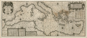 The author has not yet seen on the market any copy of this
probably earlier double-page chart of the entire Mediterranean sea including the North African coast. The copy above
from the Bibliotheque nationale de France is the only instance the author is aware of. The chart is noteworthy not
only for the fact that it is undated but that in addition to an elaborate title cartouche dedicated to
the Chevalier d’Orleans illegitimate son of Louis XIV, it contains three tables of place names
and two sets of distance scales one of which contains possibly the most elaborate engraving found on any chart Michelot
and Bremond produced. This was obviously a very special chart and one that bears a strong resemblance in the area covered
to the Michelot and Therin charts from 1690.
The author has not yet seen on the market any copy of this
probably earlier double-page chart of the entire Mediterranean sea including the North African coast. The copy above
from the Bibliotheque nationale de France is the only instance the author is aware of. The chart is noteworthy not
only for the fact that it is undated but that in addition to an elaborate title cartouche dedicated to
the Chevalier d’Orleans illegitimate son of Louis XIV, it contains three tables of place names
and two sets of distance scales one of which contains possibly the most elaborate engraving found on any chart Michelot
and Bremond produced. This was obviously a very special chart and one that bears a strong resemblance in the area covered
to the Michelot and Therin charts from 1690.
Michelot and Bremond Port Plans
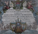
Michelot and Bremond also produced a quarto format atlas of port and harbor plans for the ca. 1730:
IN STOCK:
"Recueil de Plusiers Plans des Ports et Rades de la Mer Mediterranee".
Typically composed from 36 or 37 large-scale copperplate plans of Mediterranean ports in France, Spain, and Italy the plates in this atlas are devoid of most extraneous
decoration save a small simple cartouche on some plans and on the title page (Appendix A.).
Pages from this atlas are dated either 1727 or 1730, and many are engraved by Peter Starck-man. Several of the plans
such as this example of Alicante from 1730 are made more decorative by the engraver’s charming oblique profile
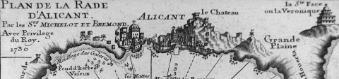 depiction of the town’s homes, churches and other structures. Here Alicante is shown with its walls, guardhouses,
and other buildings naively but attractively drawn. The engraver for this plate is not noted.
depiction of the town’s homes, churches and other structures. Here Alicante is shown with its walls, guardhouses,
and other buildings naively but attractively drawn. The engraver for this plate is not noted.
Shown above left IN STOCK: Plan de la Rade d'Alicant. Michelot and Bremond. 1730.
Summary
The author hopes that this brief summary of the few known facts about Henry Michelot and Laurens Bremond has
served to provide the reader with a bit of background on these less well-known cartographers.
The intent is to develop the reader’s appreciation for the accomplishments of these men, to examine how
their background differed substantially from the better known French cartographers and,
as this contribution is limited by the author’s reliance on secondary data sources, encourage further
research into the primary sources.
[IN STOCK: Henry Michelot and Laurens Bremond]
Appendix A: Charts appearing in one volume of Recueil de Plusiers Plans des Ports et Rades de la Mer Mediterranee.
1) Plan de la Baye et Rade de Cadis et des environs .1730. 2) Plan de la Baye de Gibraltar. 1727.
3) Plan du Port de Cartagene. 1727. 4) Plan de la Rade d'Ascombrera. 1730. 5) Plan de la Rade d'Alicant. 1730.
6) Partie de l'Isle d'Ivice, et des Isles Fromentieres. 1730. 7) Plan de la Rade de Mayorque. 1730.
8) Plan de la Baye de Poyance et de celle d'Alcudia. 1730. 9) Plan de la Baye et Rades du Sofa. 1727.
10) Plan de la Ville et Port de Barcelone. 1727. 11) Plan de la Baye et Citadelle de Rose et de Tourrille. 1727.
12) Plan du Port de Cadequie en Catalogne. 1727. 13) Plan du Pontvendre en Rousillon, en l'Etat on il ètoit en l'année 1704. 1727.
14) Plan de la Ville et Port de Colioure. 1727. 15) Plan de Ville et du Mole D'Agde en Languedoc. 1727.
16) Plan du Port de Cette aux Plages du Languedoc. 17) Plan du Port de Bonc, proche Le Martigues. 1730.
18) Plan de la Baye et Rades de Marseille. 1727. 19) Plan du Port et du Mole de la Ciotat. 1730.
20) Plan de la Rade du Brusc, et de celle de Bandot. 1730. 21) Plan de la Baye et Rades de Toulon. 1727.
22) Plan de la Baye et Rades des Isles D'Hieres. 1727. 23) Plan de la Rade du Gourjan et des Isles Ste. Marguerite. 1727.
24) Plan de la Ville et d' Antibe en l'Etat ou il etait en l'Année 1720. 1727. 25) Plan de la Baye de Ville Franche et de celle de St. Souspir. 1730.
26) Plan du Port de Genes et Vue du Fanal de Genes. 1727. 27) Plan de Porto Vecchio en l'Isle de Corse. 1730.
28) Plan de Porto Venere et du Golfe d'Especia. 1730. 29) Plan de la Ville et Port de Livourne. 1727.
30) Plan de Porto Ferraro en l'Isle de L'Elbe. 1730. 31) Plan de la Ville et Port de Civita-Vecchia. 1727.
32) Plan de la Ville et baye de Gayette. 1730. 33) Plan du Golfe de Naples. 1727.
34) Partie de la Ville et Port de Messine. 1727. 35) Plan de la Ville, Port et Rades de Palerme. 1727.
36) Plan de la Ville et Rade de Melasse. 1730. 37) Plan du Port de Trapano et des Isles Favoüillane. 1730.
References
[2] Bamford, Paul W. "Fighting Ships and Prisons: The Mediterranean Galleys of France in the Age of Louis XIV".
380 pp. 1973.
Corbett, Thomas. 1715. "The Mediterranean pilot: being an exact account of the coasts of Spain, Provence, Italy,
the islands of Yvica, Majorca, Minorca, Corsica, Sicily, &c. With a particular description of all their roads,
coasts, and harbours; the marks to know them, directions for sailing into them, and the dangers that
lie about them, and along the coasts. The soundings, and depth of water, with the nature of the ground.
The latitude of each place, with the variation of the compass, and the distance from one place to another.
The whole being collected from observations made upon the spot, by Henry Michelot, pilot on board the King of France’s
gallies. http://books.google.com/books?id=xjEBAAAAQAAJ
[3] Michelot, Henry and Nicolas Therin, Carte de la mer Méditerranée présentée à Monseigneur le chevalier de Noailles". Bibliotheque nationale de France. 1690. (West Mediterranean)
http://gallica.bnf.fr/ark:/12148/btv1b59634723.zoom.f1
Michelot, Henry. "Les Isle de Lipari & Vulcan"
Bibliotheque nationale de France. 1699.
http://gallica.bnf.fr/ark:/12148/btv1b6903574t.r=lipari+et+vulcan.langEN .
Michelot, Henry and Laurens Bremond . " Nouvelle carte Generalle de la Mer Mediterranée." Bibliotheque nationale de France. Not dated.
http://gallica.bnf.fr/ark:/12148/btv1b5962814q.zoom
Michelot, Henry and Laurens Bremond
Nouvelle Carte des Cotes de Catalogne, Roussilion, Languedoc, Provence, d’Italie, et Partie de l’Isle de Corce. Bibliotheque nationale de France. 1718.
http://gallica.bnf.fr/ark:/12148/btv1b7711261j
[1] Petto, Christine Marie "When France was king of Cartography: The Patronage and Production of Maps in Early Modern France".
215p. 2007. .
Terin, Nicolas and Henry Michelot. "Suite de la Carte de la mer Méditerranée présentée à Monseigneur le Chevalier de Noailles". Bibliotheque nationale de France. 1690. (East Mediterranean)
http://gallica.bnf.fr/ark:/12148/btv1b59634723.zoom.f2
Note: In the chart of the Eastern Mediterranean" Therin" is spelled "Terin