| | Thumbnail | | Creator | Date | Title / Author / Date / Location | Price | | | Description |
| 347 | 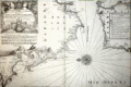 | Details | Michelot and Bremond | 1718 |
| Baye de Cadiz et Detroit de Gibraltar |
|
Michelot and Bremond |
|
| 1718 |
| LOC:57 |
| $900.00 | Michelot-and-Bremond | Baye-de-Cadiz-et-Detroit-de-Gibraltar | From the perspective of this writer this antique nautical chart of Cadiz and the Strait of Gibraltar is the most important chart of the 16 large Mediterranean sea charts by <a style="color:#9BAFCB" rel="nofollow" href= "/MichelotBremondBackground.aspx">Henry Michelot and Laurens Bremond</a> . The chart bears the earliest date of any of the 16 that were published - 1718. Also, the large decorative title cartouche at the upper left is reflective of Michelot's rank and symbols of high status. Michelot describes himself as “Hydrographe et Pilote Real des Galères du Roy” (hydrographer and pilot of the royal galley for the kings galley corps).
<BR> </BR>
The vessel depicted in the cartouche is clearly the "Reale" or Royal Galley (galère, Fr.) with three large stern lanterns. These distinctive lights served at night as a reference point for the fleet to follow. Above the galley, at the center top of the cartouche are the coat of arms of the French King surrounded on both sides by numerous banners and weapons including cannon and pikes. Perhaps the most unusual and significant decorative element is the two captive Muslim prisoners. Along with the opulent galley and other power icons the image of these near naked, chained ‘infidel’ captives would have been intended to demonstrate the map maker’s high status and authority to the map’s audience and as Petto points out, to reflect glory onto the map-makers patron to whom the charts were dedicated.<BR> </BR>
With an inset legend and a single large very decorative central compass rose and rhumb lines. Includes San Lucar de Barameda, Rota, Cape Trafalgar, Ceuta, Tangiers, Tarife (Tarifa) Gibraltar, Puerto Santa Maria and the hills of Medina Sidonia. Perhaps more than any other chart from the pair of Marseilles-based cartographers the numerous guard towers, soundings, and marked anchorages would have been important to the intended constituency for this chart- galley pilots and other coastal navigators of that period. |
| 380 | 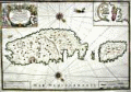 | Details | Michelot and Bremond | 1718 |
| Nouvelle Carte de 'lisle de Malthe (Malta) |
|
Michelot and Bremond |
|
| 1718 |
| LOC:0 |
| $0.00 | Michelot-and-Bremond | Nouvelle-Carte-de--lisle-de-Malthe-(Malta) | SOLD
<br></br>
Highly desirable antique nautical chart of the eastern Mediterranean islands of Malta ( Malthe ), Gozo ( Goze ), and Comino. The chart is the scarce, folio-sized nautical chart of Malta, Gozo, and Comino by French galley pilot Henry Michelot and Laurens Bremond dated 1718: "Nouvelle Carte de 'lisle de Malthe… ".
<BR> </BR>
A unique feature of this antique chart is the spouting sea serpent, not found on any of the other 17 charts by Michelot and Bremond, <a style=rel="nofollow" href= "/MichelotBremondBackground.aspx">Marseilles based cartographers</a> associated with the French Galley Service- the 'Corps des Galeres'.
<br></br>
Contains rhumb lines, two decorative compass roses and a large inset of the port of Valetta. Adorned with a decorative cartouche of unclothed captive Muslim slaves and numerous cannon, flags and other martial symbols. Contains extensive interior detail of towns, villages, hills, aqueducts, and defenses. |
| 334 | 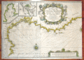 | Details | Michelot and Bremond | 1718 |
| Nouvelle Carte De Cotes De Catalogne, Roussillon, Languedoc, Provence |
|
Michelot and Bremond |
|
| 1718 |
| LOC:58 |
| $1,500.00 | Michelot-and-Bremond | Nouvelle-Carte-De-Cotes-De-Catalogne--Roussillon--Languedoc--Provence | Original antique engraved nautical chart from 1718. Left half of a double-width chart of the Northwestern Mediterranean sea titled: <br> <i>"Nouvelle Carte De Cotes De Catalogne, Roussillon, Languedoc, Provence, D'Italie et Partie De L'Isle De Corce dediee a Monseigneur le Chevalier d'Orleans General de Galeres de France par ses tres Humbles Serviteurs Michelot Hydrographe et Pilot de Galeres du Roy et Bremond Hydrographe du Roy et de la Ville" </i> Dated within an elaborate title cartouche at 1718.
<br></br> Inset port/ harbor plans include: <br>
"Plan du Port de Cette en Languedoc" <br>
"Plan du Port de Cadeques en Catalogne"
<br></br>
This antique nautical chart was produced ca. 1727 by French hydrographer and pilot of the French royal galley "La Reale" <a style="color:#9BAFCB" rel="nofollow" href= "/MichelotBremondBackground.aspx">Henry Michelot</a>. <BR> </BR>
Possibly a later impression as the chart has a small line near bottom left that appears to be the result of a cracked engraving plate. Published by Laurens Bremond from Marseilles, France. |
| 51 |  | Details | Michelot and Bremond | 1720 |
| Plan de la Baye et Rades de Marseille (small scale) |
|
Michelot and Bremond |
|
| 1720 |
| LOC:58 |
| $1,875.00 | Michelot-and-Bremond | Plan-de-la-Baye-et-Rades-de-Marseille-(small-scale) | Antique nautical chart of the Bay of Marseilles, France. Drawn by <a rel="nofollow" href= "/MichelotBremondBackground.aspx">Henri Michelot</a>, pilot of the royal galley for Louis XIV and XV. This large antique sea chart of the Bay of Marseilles would have been useful to coastal navigators such as those with the French Corps de Galeres. Extending from Cap Couronne past Cap Croisete to Morgiou the chart notes local water sources (galleys could only carry enough water for about two weeks), anchorages, and denotes a near-shore passage for the galleys near Cap Croisete: "Passage ordinaire des Galeres". The city of Marseille is shown surrounded by protective walls on three sides. <BR> </BR>
The authors' intimate knowledge of the area is confirmed by their location of several "madragues" around the bay (large anchored fish ponds or seines) that would have posed a threat to any fleet of coastal vessels operating in the area. <BR> </BR>
This chart is of special interest as Marseille the home bases for the galleys ( galère / galères ) of Louis XIV and XV as well as the home port for Michelot and Bremond. In the year this chart was published, 1720, the city of Marseille experienced an outbreak of "la peste", bubonic plague, that killed an estimated 40% of its population. The plague, spread from an arriving merchant ship, was one of the last great outbreaks in Western Europe. Perhaps it is coincidence but the location of both the Infirmerie Vieux and the Infirmerie Vielle in Marseille are indicated.<BR> </BR>
With a large beautifully engraved title cartouche by Starckman featuring Neptune with two overflowing horns-of-plenty. |
| 2511 |  | Details | Michelot and Bremond | 1723 |
| Carte Particuliere des cotes D'Espagne et de Barbarie |
|
Michelot and Bremond |
|
| 1723 |
| LOC:0 |
| $1,850.00 | Michelot-and-Bremond | Carte-Particuliere-des-cotes-D-Espagne-et-de-Barbarie | Antique, attractive early 18th-century working portolan-style nautical chart of the western Mediterranean Sea with the southern coasts of France and Spain. This original rare nautical chart was produced by Henri Michelot and Laurent Bremond, who had close, first-hand experience with many of the areas they charted.
<BR> </BR>
Chart coverage includes the Mediterranean coasts of Europe and Africa (Barbarie) from the Strait of Gibraltar and Ceuta in the west through Marbella, Malaga, Almeria and Cartagena to Cap Palle in the east. Dozens of guard towers are noted along the coast; they would have been crucial during that era of intense raiding from the Barbary coast. Includes two large insets, one of Gibraltar and the other of the Bay of Tangier (Tanger). <BR> </BR> Some unique features not found in other <a rel="nofollow" href= "/MichelotBremondBackground.aspx">Michelot and Bremond</a> antique nautical charts include a depiction of a navigator (Michelot?) sitting atop bales of merchandise embellished with initials and symbols related to the authors and engraver, and surrounded by maritime objects and navigational instruments including chart, compass and cross-staff. A separate and unexplained distance scale is included inside the neatline near bottom left. As these additional scales are found only on small-scale charts, their probable intended usage is for navigators' placement of divider points so as not to damage the master distance scale by repeated pricking. |
| 332 | 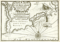 | Details | Michelot and Bremond | 1727 |
| Plan de la Ville et du Mole d'Agde in Languedoc |
|
Michelot and Bremond |
|
| 1727 |
| LOC:4 |
| $375.00 | Michelot-and-Bremond | Plan-de-la-Ville-et-du-Mole-d-Agde-in-Languedoc | Small antique nautical chart / plan depicts the small walled village of Agde, France along the lower portion of the Riviere de l'Eraux (Hérault River) with two bridges. At top left is the junction of that river with the Canal Royal (Canal du Midi) and l'Ecluse (locks), well known because of their unusual round shape. Other feature include Mont d'Adge, Fort de Brescon offshore of "le Mole" (a breakwater or jetty), la Conque, and Plage de Tau (Thau).<BR> </BR>
This antique nautical chart was produced ca. 1730 by French hydrographer and pilot of the French royal galley "La Reale" <a style="color:#9BAFCB" rel="nofollow" href= "/MichelotBremondBackground.aspx">Henry Michelot</a>. The port plan was one of 37 original plans published in Marseilles by Michelot and Laurens Bremond in a volume titled "Recueil de Plusieurs Plans de Ports et Rades de la Mer Mediterranée." Later in the 18th century the plans were copied and reprinted by Roux, Allezard, Kitchin and others. |
| 333 | 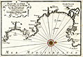 | Details | Michelot and Bremond | 1727 |
| Plan de la Baye et Citadelle de Rose et de Tourrille |
|
Michelot and Bremond |
|
| 1727 |
| LOC:4 |
| $375.00 | Michelot-and-Bremond | Plan-de-la-Baye-et-Citadelle-de-Rose-et-de-Tourrille | Interesting original antique nautical chart / plan of the vicinity of Roses, Spain from Cap de Begu (Cabo Begur) past the Riviere du Ter (el Ter river), Roses to Calla Figuire where it is noted that water could be obtained. Other features that Michelot and Bremond captured include l'Estardiez (L'Estarit), Tour de Mongon, Emporia, St Pierre le Pescador, Lescalle (L'Escala), Castillon, and the tiny Illes des Medes.
<BR> </BR>
This antique chart was produced ca. 1727 by French hydrographer and pilot of the French royal galley "La Reale" <a style="color:#9BAFCB" rel="nofollow" href= "/MichelotBremondBackground.aspx">Henry Michelot</a>. The port plan was one of 37 original plans published in Marseilles by Michelot and Laurens Bremond in a volume titled "Recueil de Plusieurs Plans de Ports et Rades de la Mer Mediterranée." Later in the 18th century the plans were copied and reprinted by Roux, Allezard, Kitchin and others. |
| 270 | 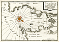 | Details | Michelot and Bremond | 1727 |
| Plan du Port de Cadequie en Catalogne |
|
Michelot and Bremond |
|
| 1727 |
| LOC:4 |
| $365.00 | Michelot-and-Bremond | Plan-du-Port-de-Cadequie-en-Catalogne | Old, rare antique nautical chart of Cadaqués, on the Costa Brava ("rough coast") of the Mediterranean Sea in Catalunya Spain. This antique 18th century antique sea chart covers the Bay of Cadeques and this northern Spanish port along with a few of the nearby mountains in the vicinity of Cape Creus. The chart shows but does not name Cadeques' only inhabited island: Isla S'Arenella.
<BR> </BR>
This among several large-scale charts of Spanish ports in Michelot's and Bremond's important 37-plate atlas of 1730: <a id="A3" href="http://www.rarecharts.com/ShowDetail/Creator/Michelot-and-Bremond/Title/Recueil-de-plusieurs-plans-des-ports-et-rades-de-la-mer-mediterranee---(Atlas-of-37-plates)/230" onclick="_gaq.push(['_trackEvent', 'Michelot and Bremond, 'View All', 'MichelotBremondBackground']);">
“Recueil de Plusiers Plans des Ports et Rades de la Mer Mediterranee". </a>
</br></br>
Single colored compass rose with rhumb lines. Numerous soundings.
<BR> </BR>
<p><a style="color:#9BAFCB" rel="nofollow" href= "/Creator/Michelot-and-Bremond">[All Items by Henry Michelot and Laurens Bremond]</a> </p> |
| 271 | 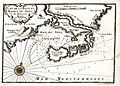 | Details | Michelot and Bremond | 1727 |
| Plan de la Baye et Rades du Sofa |
|
Michelot and Bremond |
|
| 1727 |
| LOC:4 |
| $350.00 | Michelot-and-Bremond | Plan-de-la-Baye-et-Rades-du-Sofa | Scarce large-scale antique copperplate Mediterranean / Balearic sea chart of the coast surrounding the Bay of Sofa from galley pilot Henri Michelot and Laurens Bremond. Coverage of the coast of Catalunya Spain from Les Cases de Alcanar to past the Tortosa (Tortose) river to approximately Riumar. Chart details include Serra del Montsià, Amposta (Emposta), Sant Carles de la Rapita, and the salinas.
<BR> </BR>
A monastery and numerous guard towers are identified as is a "source d'eau", of great importance to those traveling aboard the galleys which held only enough water for two weeks at best.
<BR> </BR>
Single colored compass rose with rhumb lines. Numerous soundings.
<BR> </BR>
<p><a style="color:#9BAFCB" rel="nofollow" href= "/Creator/Michelot-and-Bremond">[All Items by Henry Michelot and Laurens Bremond]</a> </p> |
| 331 | 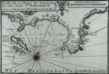 | Details | Michelot and Bremond | 1727 |
| Plan de la Rade du Gourjan et des Isles Ste. Marguerite |
|
Michelot and Bremond |
|
| 1727 |
| LOC:4 |
| $425.00 | Michelot-and-Bremond | Plan-de-la-Rade-du-Gourjan-et-des-Isles-Ste--Marguerite | Antique copperplate-engraved nautical chart / plan of the islands, bay, and beaches between Cane (Cannes) and Antibe, France in the Cote d'Azur region of the French Riviera. Islands noted offshore by Michelot include Isle St. Honora (Saint-Honorat ) and Île Sainte-Marguerite which is one of the locations where the "man in the Iron Mask" is known to have been jailed. Other features are Pointe de la Foucade (Fourcade) Cap de la Garoupe, tours de la Croisette on (Cap de la Croisette) and two beaches: plage du pilon, and plage qui conduit a Nice.<BR> </BR>
This antique chart / plan was produced ca. 1730 by French hydrographer and pilot of the French royal galley "La Reale" <a style="color:#9BAFCB" rel="nofollow" href= "/MichelotBremondBackground.aspx">Henry Michelot</a>. The port plan was one of 37 original plans published in Marseilles by Michelot and Laurens Bremond in a volume titled "Recueil de Plusieurs Plans de Ports et Rades de la Mer Mediterranée." Later in the 18th century the plans were copied and reprinted by Roux, Allezard, Kitchin and others. |
| 254 | 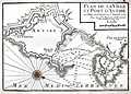 | Details | Michelot and Bremond | 1727 |
| Plan de la Ville et Port d'Antibe (Antibes) |
|
Michelot and Bremond |
|
| 1727 |
| LOC:4 |
| $300.00 | Michelot-and-Bremond | Plan-de-la-Ville-et-Port-d-Antibe-(Antibes) | Highly detailed, engraved port plan of Antibes, France on the French Riviera or Cote d'Azur. Highlighted by a colored compass rose, this old antique chart / plan shows the city and fort of Antibes both surrounded by defensive walls. Numerous soundings, underwater hazards, and anchorages are noted in and near Antibes harbor. This nautical chart was produced in 1727 by French hydrographers and galley (galère, Fr.) pilot <a style="color:#9BAFCB" rel="nofollow" href= "/MichelotBremondBackground.aspx">Henry Michelot</a> and Laurens Bremond.
<BR> </BR>
A note in the title cartouche states that the chart is based on information that was current as of 1720. The distance scale is in toises which was about 1.95 meters before 1812. |
| 4708 | 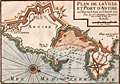 | Details | Michelot and Bremond | 1727 |
| Plan de la Ville et Port d'Antibe (Antibes) |
|
Michelot and Bremond |
|
| 1727 |
| LOC:13 |
| $350.00 | Michelot-and-Bremond | Plan-de-la-Ville-et-Port-d-Antibe-(Antibes) | Highly detailed, engraved port plan of Antibes, France on the French Riviera or Cote d'Azur, based on information that was current as of 1720. Highlighted by a colored compass rose oriented with north to bottom right, this old antique chart / plan shows Antibes surrounded by Vauban-style defensive walls. Key noted features include "le Chateau", land and sea entrances (ports), le mole or jetty, the Fort d'Antibes and a beach leading to Nice - "Plage qui conduit a Nice."
<BR> </BR>
Numerous soundings, underwater hazards, and anchorages are noted in and near Antibes harbor. This nautical chart was produced in 1727 by French hydrographers and galley (galère, Fr.) pilot Henry Michelot and Laurens Bremond.
<BR> </BR>
The distance scale is in toises which was about 1.95 meters before 1812. |
| 100 |  | Details | Michelot and Bremond | 1727 |
| Plan du Port du Portvendre en Roussillon |
|
Michelot and Bremond |
|
| 1727 |
| LOC:4 |
| $300.00 | Michelot-and-Bremond | Plan-du-Port-du-Portvendre-en-Roussillon | Interesting large-scale, black and white copperplate antique nautical chart / plan of Portvendre (Port-Vendres), France with a carefully colored compass rose. This antique chart is one of 37 port plans published by <a rel="nofollow" href= "/MichelotBremondBackground.aspx">Henry Michelot and Laurens Bremond</a> ca. 1730 in their atlas of small scale Mediterranean ports: "Recueil de Plusieurs Plans de Ports et Rades de la Mer Mediterranée" .
<BR> </BR>
Notations are made on both sides of the bay warning that the surrounding land is high. It must have been a welcome sight when a navigator finally spied the beach near the harbor where a galley (galère) could land. Along with two forts, the few noted points of interest include a water source, a chapel, and a few stores. |
| 250 | 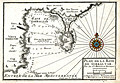 | Details | Michelot and Bremond | 1727 |
| Plan de la Baye de Gibraltar |
|
Michelot and Bremond |
|
| 1727 |
| LOC:4 |
| $300.00 | Michelot-and-Bremond | Plan-de-la-Baye-de-Gibraltar | An attractive and scarce antique copperplate large scale chart of the bay and peninsula of Gibraltar, a British Overseas Territory. Contains detail on the fortifications and numerous guard towers in the area. Numerous soundings, anchorages, and navigation hazards are noted. Hand colored compass rose. Algeciras is labeled "Vieux Gibraltar". Other noted locations include the old and new quay (mole), Cap Carnero, Plaine de St. Roch and the Ville et Mt. Gibraltar (Rock of Gibraltar).
<br></br>
This plan was produced in 1727 by French hydrographers and galley pilot <a style="color:#9BAFCB" rel="nofollow" href= "/MichelotBremondBackground.aspx">Henry Michelot</a> and Laurens Bremond . This old chart of Gibraltar is one of a handful of Michelot and Bremond charts that were copied by Thomas Kitchin and others for more than 30 years and it should be a part of any serious collection of maps from that region.
<BR> </BR>
Engraved by one of the finest engravers of the time, Peter Starckman. Carries the sellers information: " Ce Vend chez Laurens Bremond sur le Port a Marseilles a coin de Reboul." Published with the royal privilege. |
| 46 | 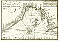 | Details | Michelot and Bremond | 1727 |
| Plan de la Baye et Rades de Marseille LS |
|
Michelot and Bremond |
|
| 1727 |
| LOC:4 |
| $0.00 | Michelot-and-Bremond | Plan-de-la-Baye-et-Rades-de-Marseille-LS | SOLD<br></br>
Antique, original copperplate portulan-style coastal chart / plan of the Bay of Marseille and nearby islands. Coverage includes coastal France from Cap Couronne to Port Estat. Marseille shown with fortifications as they existed in the early 18th century.<BR> </BR>
Numerous soundings and marked anchorages on this antique nautical chart would have been useful to galley pilots and other mariners calling at Marseille. Single compass rose with radiating rhumb lines and fleur de lis indicating north. <a rel="nofollow" href= "/MichelotBremondBackground.aspx">Henry Michelot's</a> chart of Marseille was often copied by others such as Kitchin well into the late 1700's.<BR> </BR>
This chart is of special interest as Marseille was the chief base for the galleys (galères) of Louis XIV and XV as well as the home port for Michelot and Bremond. Also note that just seven year earlier, in 1720, the city of Marseilles had been subject to an outbreak of "la peste", bubonic plague that killed an estimated 40% of its population. The plague, spread from an arriving merchant ship was one of the last great outbreaks in Europe. |
| 817 | 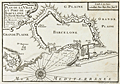 | Details | Michelot and Bremond | 1727 |
| Barcelona, Spain port and fortification plan |
|
Michelot and Bremond |
|
| 1727 |
| LOC:4 |
| $200.00 | Michelot-and-Bremond | Barcelona--Spain-port-and-fortification-plan | One of the first port plans of Barcelona, Spain (from 1727) created for navigational purposes in an atlas for the Mediterranean Sea: “Recueil de Plusiers Plans des Ports et Rades de la Mer Mediterranee". This chart was published by the team of Henri Michelot and Laurens Bremond, both associated with the French Royal Galley Corps. In their business relationship it appears that Bremond provided the retail space in the port of Marseille, France where this chart, as well as other atlases and nautical prints were sold. Michelot, the chief pilot or "Pilote Hauturière" for the galley service provided the name recognition and authority needed for the charts to sell widely.
<br></br>
The chart covers from Mont-Jouy ( Montjuïc ) in the West to the far Eastern walls at Barcelona's edge. The chart shows Barcelona's fortifications with numerous bastions; redoubts, gun batteries, windmills, the arsenal, and 5 entrances into the city: the Porte de Mont-Jout; Porte St. Antoine; Porte de l'Ange; Porte Neuve; and Porte de la Marine, near the harbor. Depth soundings extend only in the interior harbor, and are interspersed with anchor symbols reflecting locations where sea-going vessels could find shelter. In the title cartouche the authors note that the plan is based on the state they observed in 1697, likely during Michelot's service for the Louis XIV's Corps des Galeres. |
| 251 | 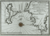 | Details | Michelot and Bremond | 1727 |
| Partie de l'Isle d'Yvice et des Isles Fromentieres (Ibiza and Formentera islands) |
|
Michelot and Bremond |
|
| 1727 |
| LOC:0 |
| $0.00 | Michelot-and-Bremond | Partie-de-l-Isle-d-Yvice-et-des-Isles-Fromentieres-(Ibiza-and-Formentera-islands) | <a rel="nofollow" href= "http://www.rarecharts.com/ShowDetail/Creator/Michelot-and-Bremond/Title/Antique-chart-of-the-Balearic-Islands-of-Ibiza-and-Formentera/819"> SOLD, but see another copy in our stock.</a> <BR> </BR>
Original small engraved nautical chart of the Balearic islands of Ibiza and Formentera which now belong to an autonomous unit and province of Spain. Shows the port and the town of Elvissa which is labeled "Yvice". This chart is one of 37 port plans published by <a style="color:#9BAFCB" rel="nofollow" href= "/MichelotBremondBackground.aspx">Henry Michelot and Laurens Bremond</a> ca. 1730 in their atlas of small scale Mediterranean ports: "Recueil de Plusieurs Plans de Ports et Rades de la Mer Mediterranée" . <BR> </BR>
Contains a carefully colored compass rose. |
| 49 | 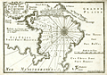 | Details | Michelot and Bremond | 1727 |
| Plan du Port de Cartagena |
|
Michelot and Bremond |
|
| 1727 |
| LOC:4 |
| $300.00 | Michelot-and-Bremond | Plan-du-Port-de-Cartagena | Large-scale original, antique chart / plan from galley pilot Henri Michelot and Laurens Bremond of the Mediterranean harbor and town of Cartagena, Spain. Very attractive pictorial profile view of Cartagena as it looked at that time surrounded by city walls at the beach and by hills to the east. The "Petit Fort" is shown guarding the entrance to the harbor. Other features that Michelot references by name include: "le Chateau", the "Masse de Moulin", a "Grotte ou Caverne", the "Grand Valong" and "l'Ermitage" to the east of Cartagena.
<BR> </BR>
Single compass rose with rhumb lines. Numerous soundings include several warnings about a dangerous area. See also the offered large-scale antique chart of the anchorage of Escombreras ("Rade d'Ascombrera") which provides detail of the environs along roughly a seven-mile stretch of coastline directly south of Cartagena. |
| 328 | 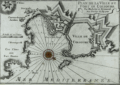 | Details | Michelot and Bremond | 1728 |
| Plan de la Ville et Port de Colioure |
|
Michelot and Bremond |
|
| 1728 |
| LOC:4 |
| $300.00 | Michelot-and-Bremond | Plan-de-la-Ville-et-Port-de-Colioure | Fine antique print with a depiction and plan of the harbor and village of Colioure (Collioure), in Southern France near the border of Spain. Features include Fort Saint-Elme, Convent de Jacobins, the Chateau Royal and l'Ermitage. Thick Vauban-designed defensive walls are shown surrounding the Chateau and village.<BR> </BR>
This nautical chart / plan was produced ca. 1730 by French hydrographer and pilot of the French royal galley "La Reale" <a style="color:#9BAFCB" rel="nofollow" href= "/MichelotBremondBackground.aspx">Henry Michelot</a>. The port plan was one of 37 original plans published in Marseilles by Michelot and Laurens Bremond in a volume titled "Recueil de Plusieurs Plans de Ports et Rades de la Mer Mediterranée." Later in the 18th century the plans were copied and reprinted by Roux, Allezard, Kitchin and others. |
| 329 | 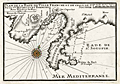 | Details | Michelot and Bremond | 1730 |
| Plan de la Baye de Villefranche et de Celle de St. Souspir |
|
Michelot and Bremond |
|
| 1730 |
| LOC:4 |
| $375.00 | Michelot-and-Bremond | Plan-de-la-Baye-de-Villefranche-et-de-Celle-de-St--Souspir | Interesting antique chart / plan of the bay, harbor and walled city of Villefranche-sur-Mer, France in the Cote d'Azur region of the French Riviera. Numerous soundings and anchorages are noted in the bay which is one of the deepest natural harbors in the Mediterranean. Other depicted features include the Ruines du Chateau de Nice, the old harbor "la Darce", Fort Mont Alban, Tour de Boze, Pointe de Mala Langue (now Cap Ferrat) , Ruines de Fort St. Souspir, and the villages of St. Michel and Heze (Èze). <BR> </BR>
This antique nautical plan was produced ca. 1730 by French hydrographer and pilot of the French royal galley "La Reale" <a style="color:#9BAFCB" rel="nofollow" href= "/MichelotBremondBackground.aspx">Henry Michelot</a>. The port plan was one of 37 original plans published in Marseilles by Michelot and Laurens Bremond in a volume titled "Recueil de Plusieurs Plans de Ports et Rades de la Mer Mediterranée." Later in the 18th century the plans were copied and reprinted by Roux, Allezard, Kitchin and others. |
| 330 | 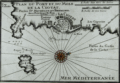 | Details | Michelot and Bremond | 1730 |
| Plan du Port et du Mole de la Ciotat |
|
Michelot and Bremond |
|
| 1730 |
| LOC:4 |
| $355.00 | Michelot-and-Bremond | Plan-du-Port-et-du-Mole-de-la-Ciotat | Antique copper-plate engraved nautical chart / plan of the area surrounding la Ciotat, France in the Cote d'Azur region of the French Riviera. Named features noted by Michelot in this antique chart include Cap Canaille, Cap de l'Aigle, the fountaine du prat; port, mole (jetty or breakwater), and fort of la Ciotat; les Capucins, and Pointe des Moulins.<BR> </BR>
This plan was produced ca. 1730 by French hydrographer and pilot of the French royal galley "La Reale" <a style="color:#9BAFCB" rel="nofollow" href= "/MichelotBremondBackground.aspx">Henry Michelot</a>. The port plan was one of 37 original plans published in Marseilles by Michelot and Laurens Bremond in a volume titled "Recueil de Plusieurs Plans de Ports et Rades de la Mer Mediterranée." Later in the 18th century the plans were copied and reprinted by Roux, Allezard, Kitchin and others. |
| 252 | 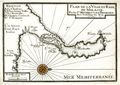 | Details | Michelot and Bremond | 1730 |
| Plan de la Ville et Rade de Melasse (Milazzo, Sicily) |
|
Michelot and Bremond |
|
| 1730 |
| LOC:4 |
| $300.00 | Michelot-and-Bremond | Plan-de-la-Ville-et-Rade-de-Melasse-(Milazzo--Sicily) | Antique copperplate chart of Cape Milazzo, Sicily from French galley pilot and hydrographer <a style="color:#9BAFCB" rel="nofollow" href= "/MichelotBremondBackground.aspx">Henri Michelot.</a> This is one of four old charts of Sicilian ports in Michelot's and Bremond's important 37-plate atlas of 1730: <a id="A3" href="http://www.rarecharts.com/ShowDetail/Creator/Michelot-and-Bremond/Title/Recueil-de-plusieurs-plans-des-ports-et-rades-de-la-mer-mediterranee---(Atlas-of-37-plates)/230" onclick="_gaq.push(['_trackEvent', 'Michelot and Bremond, 'View All', 'MichelotBremondBackground']);">
“Recueil de Plusiers Plans des Ports et Rades de la Mer Mediterranee". </a>
<BR> </BR>
The town of Milazzo (Melasse) , Sicily is clearly shown surrounded by Vauban-style defensive walls and the nearby sea area is marked with sparse soundings and a few anchorages. The charts contains a feature that is unusual for these smaller plans-- labeled, keyed references to five locations in Milazzo: Le Chateau; l'Ancienne Ville; La Nouvelle; Chemin Couvert; and St. Francois. These detailed labels suggest a high level of familiarity with the area. |
| 818 | 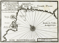 | Details | Michelot and Bremond | 1730 |
| Bay of Palma, on Mallorca, Spain (Balearics) |
|
Michelot and Bremond |
|
| 1730 |
| LOC:4 |
| $200.00 | Michelot-and-Bremond | Bay-of-Palma--on-Mallorca--Spain-(Balearics) | One of the first port plans of the Bay of Palma, Spain (1730) on the Balearic Island of Mallorca (Majorca) created for navigational purposes in an atlas for the Mediterranean Sea: “Recueil de Plusiers Plans des Ports et Rades de la Mer Mediterranee". The chart covers from Fort de Porto pin in the West to the far plains east of Palma ( "Palme") . Shows the region around Palama including fortifications, bastions, redoubts, gun batteries, and numerous windmills both to the east and west of the city. The Bay of Palma is referred to as the "Golfe de Mayorque".
<br></br>
This chart was published by the team of Henri Michelot and Laurens Bremond, both associated with the French Royal Galley Corps. In their business relationship it appears that Bremond provided the retail space in the port of Marseille, France where this chart, as well as other atlases and nautical prints were sold. Michelot, the chief pilot or "Pilote Hauturière" for the galley service provided the name recognition and authority needed for the charts to sell widely. |
| 819 | 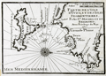 | Details | Michelot and Bremond | 1730 |
| Antique chart of the Balearic Islands of Ibiza and Formentera |
|
Michelot and Bremond |
|
| 1730 |
| LOC:4 |
| $200.00 | Michelot-and-Bremond | Antique-chart-of-the-Balearic-Islands-of-Ibiza-and-Formentera | Original engraved antique nautical chart of the Balearic islands of Ibiza and Formentera which now belong to an autonomous unit and province of Spain. The French chart, from 1730, shows the port and the town of Eivissa or Ibiza Town which is labeled "Yvice". Other noted points of interest include: Cap Saline, Porto Magno or Galache Fraques, Ile de Tagomago, and Ile Espalmador. Numerous soundings , anchorages, and rocks are noted as well as a water source near the village of St. Hilaire.
<BR> </BR>
This chart is one of 37 port plans published by <a style="color:#9BAFCB" rel="nofollow" href= "/MichelotBremondBackground.aspx">Henry Michelot and Laurens Bremond</a> ca. 1730 in their atlas of small scale Mediterranean ports: "Recueil de Plusieurs Plans de Ports et Rades de la Mer Mediterranée" . Both Michelot and Bremond were associated with the French Royal Galley Corps. In their business relationship it appears that Bremond provided the retail space in the port of Marseille, France where this chart, as well as other atlases and nautical prints were sold. Michelot, the chief pilot or "Pilote Hauturière" for the Corps des Galeres provided the name recognition and authority needed for the charts to sell widely. |
| 4707 | 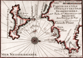 | Details | Michelot and Bremond | 1730 |
| Antique French nautical chart of Ibiza and Formentera, Balearic Islands, Spain |
|
Michelot and Bremond |
|
| 1730 |
| LOC:13 |
| $350.00 | Michelot-and-Bremond | Antique-French-nautical-chart-of-Ibiza-and-Formentera--Balearic-Islands--Spain | Attractive and authentic antique engraved nautical chart of the <b>Balearic islands of Ibiza and Formentera, Spain.</b> Includes the noted locations of St. Hilaire, Porto Magno, Cap Saline, Isle des Salines, and Isle Tagomago. The authors identify anchorages, navigation hazards, depth soundings, watering locations, and a shallow northern passage between the islands labeled "on peut passer ici par un beau tems." Shows the port and the town of Elvissa labeled "Yvice".
<BR> </BR>
This small antique chart is one of 37 port plans and harbor charts published by Henry Michelot and Laurens Bremond ca. 1730 in their small-scale atlas of Mediterranean ports: "Recueil de Plusieurs Plans de Ports et Rades de la Mer Mediterranée."
<BR> </BR>
Contains a carefully colored compass rose with north oriented to the right, |
| 101 | 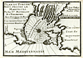 | Details | Michelot and Bremond | 1730 |
| Plan du Port de Bouc |
|
Michelot and Bremond |
|
| 1730 |
| LOC:4 |
| $300.00 | Michelot-and-Bremond | Plan-du-Port-de-Bouc | Antique copperplate nautical chart / port plan of the entrance to the harbor at Port-de-Bouc near Martigues, France produced by French hydrographer and galley pilot Henry Michelot and Laurens Bremond in 1730 . Along with many soundings and navigation hazards the features that Michelot deemed important and referenced by name include a "Pigeonnier", the beach "Plage de Fos", a tower "Tour de Bouc", and numerous "Bordigues" or fish weirs.
<BR> </BR>
Michelot describes Bouc harbor in the English translation of his book of sailing directions published in 1715 - "The Mediterranean Pilot". Michelot's self-confidence in his superior knowledge of the region is unmistakable: <br><div class="indenttextblock">"The mouth is very narrow being only 150 fathoms over; on the starboard point as you go in there is a fortress with a square tower in the middle, of white stone which is seen a great way off; it stands at a low point of an island, which is only separated from the main land by a small rivolet, The Dutch and some authors set down the entrance of this port in their sea-mapps to the eastward of this island where the tower of Bouc is; which shows they have never used this coast, no more than the author of the little Flambeau, printed at Harve de Grace."</div> |
| 1020 |  | Details | Michelot and Bremond | 1730 |
| 1730 Plan of Port-de-Bouc, near Martigues, France |
|
Michelot and Bremond |
|
| 1730 |
| LOC:50 |
| $320.00 | Michelot-and-Bremond | 1730-Plan-of-Port-de-Bouc--near-Martigues--France | Antique copperplate nautical port plan of the entrance to the harbor at Port-de-Bouc near Martigues, France produced by French hydrographer and galley pilot Henry Michelot and hydrographer Laurens Bremond in 1730 . Colored compass rose at center with rhumb lines and numerous soundings.
<br></br>
Along with soundings and navigation hazards the features that Michelot deemed important near Port-de-Bouc and referenced by name include a "Pigeonnier", the beach "Plage de Fos", a tower and fortress "Tour de Bouc", and numerous "Bordigues" or fish weirs. |
| 253 | 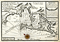 | Details | Michelot and Bremond | 1730 |
| Plan de la Baye et Rades de Cadis et des Environs (Cadiz) |
|
Michelot and Bremond |
|
| 1730 |
| LOC:4 |
| $300.00 | Michelot-and-Bremond | Plan-de-la-Baye-et-Rades-de-Cadis-et-des-Environs--(Cadiz) | Highly detailed antique chart of Cadiz, Spain from Rota to Chiclana showing guard towers, water sources, salt pans, and defenses with prominent topographical features drawn pictorially. Among the many noted habitations are: Medina (Medina-Sidonia), Rota (Rotta), St. Maria, Chiclana, and Puerto Real. Other features include Tour (tower) St. Sebastien, Tours d'Hercule, Canal de St. Pierre (with locations where galleons we built and careened), , Tour Vermea, Fort Matagord, Fort St. Laurent, and the Isle de Tour de St. Pierre.
<BR> </BR>
Of special note is the hilltop village of Medina (Medina-Sidonia) used as a range marker for the main channel into the Bay of Cadiz. That village has a history that dates back to Roman times and was the ancestral home to the Duke of Medina Sidonia who reluctantly led and lost the Spanish "Invincible" Armada on a planned invasion of England in 1588.
<br></br>
This old chart and port plan of Cadiz is one of a handful of Michelot and Bremond charts that were copied by Thomas Kitchin and others for more than 30 years and it should be a part of any serious collection of maps from that region. The charts were published from Marseilles in Michelot's and Bremond's important 37-plate atlas of 1730: <a id="A3" href="http://www.rarecharts.com/ShowDetail/Creator/Michelot-and-Bremond/Title/Recueil-de-plusieurs-plans-des-ports-et-rades-de-la-mer-mediterranee---(Atlas-of-37-plates)/230" onclick="_gaq.push(['_trackEvent', 'Michelot and Bremond, 'View All', 'MichelotBremondBackground']);">
“Recueil de Plusiers Plans des Ports et Rades de la Mer Mediterranee". </a>
<BR> </BR>
Numerous soundings, underwater hazards, and anchorages are noted. Colored compass rose. |
| 327 |  | Details | Michelot and Bremond | 1730 |
| Plan de la Baye de Poyance et de Celle d'Alcudia |
|
Michelot and Bremond |
|
| 1730 |
| LOC:0 |
| $0.00 | Michelot-and-Bremond | Plan-de-la-Baye-de-Poyance-et-de-Celle-d-Alcudia | SOLD<BR> </BR>
Scarce antique chart / plan of the Bays of Poyance (Pollensa or Pollenca) and Alcudia with Cap Fromentel (Formentor) on the island of Mallorca (Majorca). The villages of Alcudia and Poyance are each depicted as perched atop a hill and the surrounding area is protected by several guard towers which also would have served as navigational aids to the coastwise navigator. Composition of beaches, anchorages, and soundings are noted along with a water source. These details would have been of special interest to passing galleys.<BR> </BR>
This plan was produced ca. 1730 by French hydrographer and pilot of the French royal galley "La Reale" <a style="color:#9BAFCB" rel="nofollow" href= "/MichelotBremondBackground.aspx">Henry Michelot</a>. The port plan was one of 37 original plans published in Marseilles by Michelot and Laurens Bremond in a volume titled "Recueil de Plusieurs Plans de Ports et Rades de la Mer Mediterranée." Later in the 18th century the plans were copied and reprinted by Roux, Allezard, Kitchin and others. |
| 230 |  | Details | Michelot and Bremond | 1730 |
| Recueil de plusieurs plans des ports et rades de la mer mediterranee. (Atlas of 37 plates) |
|
Michelot and Bremond |
|
| 1730 |
| LOC:0 |
| $6,500.00 | Michelot-and-Bremond | Recueil-de-plusieurs-plans-des-ports-et-rades-de-la-mer-mediterranee---(Atlas-of-37-plates) | Scarce and complete atlas of 37 large-scale 10" x 7" antique engraved Mediterranean port and harbor plans by French hydrographers and galley (galère, Fr.) pilot Henry Michelot and Laurens Bremond. </br> </br>
<strong><a href= "/MBPlansViewer.aspx">[ Browse all 37 charts here ]</a></strong>
</br></br> This 12" x 8" atlas, published ca. 1730 was the culmination of Henry Michelot's career; the result of at least 40 years experience as pilot of the Reale, premier vessel in the galley service of Louis XIV and XV. These charts are influenced by and bear similarities to a set of manuscript charts published by Michelot from Marseille around 1689 but are updated to reflect his cumulative experience over the intervening 40 years. With an elaborately engraved title page. Some charts engraved by Peter Starck-man. <BR> </BR>
This 290-year old sea atlas contains port plans from France, Italy, and Spain including Barcelona, Antibe, Mayorca, Bay of Naples, Bay of Gibraltar, and Cadiz. Several of these charts (e.g. Cadiz, Gibraltar) were considered to be the most authoritative works of that era and were copied by others including Thomas Kitchin well into the mid 18th century.<BR> </BR>
For more information on the life and works of Henry Michelot and his business partner Bremond see our <a rel="nofollow" href= "/MichelotBremondBackground.aspx">brief illustrated biography.</a> |
| 48 | 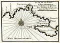 | Details | Michelot and Bremond | 1730 |
| Plan de la Rade d'Ascombrera |
|
Michelot and Bremond |
|
| 1730 |
| LOC:4 |
| $300.00 | Michelot-and-Bremond | Plan-de-la-Rade-d-Ascombrera | Large-scale antique copperplate-engraved nautical chart / plan of waters offshore Cartagena, Spain from French galley pilot and hydrographer <a rel="nofollow" href= "/MichelotBremondBackground.aspx">Henri Michelot.</a> Coverage extends roughly from Cabo Tinoso (Cap-Tignoso) past Cartagena, Spain; Escombrera Island and Bay, and ends in the east near Cabo del Aqua. Single compass rose with rhumb lines radiating in all directions. Highlight detail includes the "Chapelle des Galères" not too far from a beach at the head of Escombrera bay. <BR> </BR>
See also the related large-scale <a rel="nofollow" href= "/ShowDetail/Creator/Michelot-and-Bremond/Title/Plan-du-Port-de-Cartagena/49">antique chart / plan of Cartagena, Spain</a> which provides detail of the city and the harbor directly south of Cartagena. When framed both charts together would make an attractive grouping. |
| 1056 | 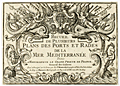 | Details | Michelot and Bremond | 1730 |
| Michelot Title Page - Recueil de Plusieurs Plans des Ports et Rades (2) |
|
Michelot and Bremond |
|
| 1730 |
| LOC:1 |
| $215.00 | Michelot-and-Bremond | Michelot-Title-Page---Recueil-de-Plusieurs-Plans-des-Ports-et-Rades-(2) | Title page to "Recueil de Plusieurs Plans des Ports et Rades de la Mer Mediterranee", <a rel="nofollow" href= "/MichelotBremondBackground.aspx">Henry Michelot and Laurens Bremond's</a> quarto-sized atlas of Mediterranean ports and harbors published between 1727 and 1730. This elaborately engraved title page is very rarely found alone, usually only as one of the 38 plates in a copy of the complete Michelot and Bremond atlas.
<BR> </BR>
Interesting note is that on the bottom neatline, previously engraved wording has been hastily covered over before printing, with just top and bottom of characters still visible. |
| 216 |  | Details | Michelot and Bremond | 1730 |
| Title Page - Recueil de Plusieurs Plans des Ports et Rades |
|
Michelot and Bremond |
|
| 1730 |
| LOC:4 |
| $475.00 | Michelot-and-Bremond | Title-Page---Recueil-de-Plusieurs-Plans-des-Ports-et-Rades | Title page to "Recueil de Plusieurs Plans des Ports et Rades de la Mer Mediterranee", <a rel="nofollow" href= "/MichelotBremondBackground.aspx">Henry Michelot and Laurens Bremond's</a> quarto-sized atlas of Mediterranean ports and harbors published between 1727 and 1730. This elaborately engraved title page is very rarely found alone, usually only as one of the 38 plates in a copy of the complete Michelot and Bremond atlas.
<BR> </BR>
Interesting note is that on the bottom neat line, previously engraved wording has been hastily covered over before printing, with just top and bottom of characters still visible. |
| 47 |  | Details | Michelot and Bremond | 1730 |
| Plan de la Rade d'Alicant |
|
Michelot and Bremond |
|
| 1730 |
| LOC:4 |
| $300.00 | Michelot-and-Bremond | Plan-de-la-Rade-d-Alicant | Antique copperplate portulan-style nautical chart / plan of Alicante, Spain and nearby waters.
<BR> </BR>
This chart is one of 37 port plans published by <a rel="nofollow" href= "/MichelotBremondBackground.aspx">Henry Michelot and Laurens Bremond</a> ca. 1730 in their atlas of small scale Mediterranean ports: "Recueil de Plusieurs Plans de Ports et Rades de la Mer Mediterranée" . Single compass rose with radiating rhumb lines and fleur de lis indicating north. Charming profile view of Alicante topped by "le Chateau". Chart coverage extends eastward from a guard tower past Cap de la Houerta and ends at the prominent villa "la Ste. Face ou la Veronique".<BR> </BR>
Obligatory '+' symbols for rock at every headland and few soundings suggest that the authors were not as familiar with these waters as with other areas they charted. Three suggested anchorages are designated. These anchorages are arranged as expected by the relative draft of each vessel. The "mouillage de vaisseaux" is farthest from shore, with the "mouillage des barques" and "mouillage des galeres" each in progressively shallower water. |
| 208 | 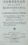 | Details | Michelot and Bremond | 1805 |
| Portulan de la Mer Méditerranée |
|
Michelot and Bremond |
|
| 1805 |
| LOC:0 |
| $600.00 | Michelot-and-Bremond | Portulan-de-la-Mer-Méditerranée | Very rare antique edition of this book of sailing directions by Henry Michelot whose earliest career with Louis XIV's Corp des Galeres (Galley Corps) dates to approximately 1675. This edition published in French by Jean Mossy in 1805 is updated with sailing directions for the Levant coast and Greek Archipelago not found in the original 1703 edition. <BR> </BR>
For the collector of <a rel="nofollow" href= "/MichelotBremondBackground.aspx">Michelot and Bremond sea charts</a> this volume provides fascinating background and depth into their early works. 596 pages including an index. Includes a preface by Mossy. No maps or illustrations (as issued). |