DESCRIPTION: SOLD
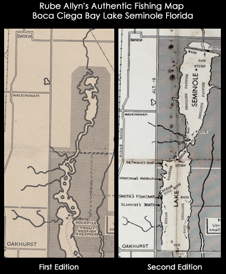
Scarce second edition [1] of Rube Allyn's Authentic Fishing Map (ca. 1955), for Boca Ciega Bay and Lake Seminole, Florida. When multiple editions of Allyn's fishing map exist for the same area, they may provide a good source of information about changes over time to the aquatic environment and to fish populations. Allyn's chart # 1B.
Clearly shows the immediate effect of a new dam across Long Bayou built in the 1940's at Park Blvd. N., then Oakhurst. The dam was intended to turn part of a salt-water estuary into a freshwater lake, Lake Seminole, with water level controlled by a weir along the south side of the lake. When this fishing chart is compared to Allyn's first edition made before the dam was constructed, it is clear chart that the dam was a huge success. Lake Seminole is shown swollen with water, and Allyn notes abundant fresh-water fish rather than the trout and redfish that previously inhabited the salt-water Long Bayou.

As is often the case with projects that change the environment, after decades they bring about unexpected consequences. Today, water quality is a concern on Lake Seminole because of the low volume of water flowing into the lake, coupled with excess nutrients and pollution runoff from the surrounding urban areas. The Lake Seminole Restoration Project will dredge 900,000 cubic yards of accumulated organic sediment from the lake to include 54 tons of phosphorus and 311 tons of nitrogen. (Source: http://www.pinellascounty.org/publicworks/pdf/lake-seminole-restoration-project.pdf)
[1] Rube Allyn's Authentic Fishing Map (Upper) Boca Ciega Bay and Gulf Beaches. 1st ed. Touchton Map Library. Tampa Bay History Center. 2016.010.002 .
PUBLICATION DATE: 1955
GEOGRAPHIC AREA: United States
BODY OF WATER: Lake Seminole
CONDITION: Fair.
Solid but with a few pinholes at fold intersections. Stains near the fold at Seminole Lake. Folds.
COLORING: None.
ENGRAVER:
SIZE: 20
" x
25 "
ITEM PHYSICAL LOCATION: 61
PRICE: $
ADD TO CART

|