| | Thumbnail | | Creator | Date | Title / Author / Date / Location | Price | | | Description |
| 4883 |  | Details | Allyn, Rube | 1955 |
| 2nd ed. Fishing Map Upper Tampa Bay |
|
Allyn, Rube |
|
| 1955 |
| LOC:0 |
| $0.00 | Allyn--Rube | 2nd-ed--Fishing-Map-Upper-Tampa-Bay | SOLD
<br></br>
Scarce presumed <b>second edition</b> [1] of Rube Allyn's Authentic Fishing Map (ca. 1955), for upper Tampa Bay, Florida. Changes made on the 2nd edition not on the 1st edition include:
<div class="indenttextblocksingle">
<ul style="list-style-type: circle;">
<li>A "nice beach" and a new (dredged?) channel in Tampa Bay, both in the vicinity of Sky Harbor Airport</li>
<li>Several new additions to the Gandy Blvd. west peninsula including two new boat launches and a TV tower.</li>
<li>Reclassification of spoil banks as Treasure Island and Lookout Island.</li>
</ul>
</div>
The changes on this second edition are easily identifiable from the different font used to the new / changed items. The newer changes appear to have been made by pasting typewritten location names to the 1st edition master copy before reproduction.
<br></br>
When multiple editions of Allyn's fishing map exist for the same area, as in this case, they may provide a good source information about the effects of development and changes over time to the aquatic environment and to fish populations. Allyn's chart # 1C.
<br></br>
[1] Rube Allyn's Authentic Fishing Map Upper Tampa Bay. 1st ed. Touchton Map Library. Tampa Bay History Center. 2016.010.003. |
| 4876 | 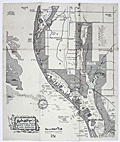 | Details | Allyn, Rube | 1955 |
| 2nd ed. Map Lake Seminole Florida Fresh Water |
|
Allyn, Rube |
|
| 1955 |
| LOC:61 |
| $0.00 | Allyn--Rube | 2nd-ed--Map-Lake-Seminole-Florida-Fresh-Water | SOLD <br><br>
Scarce <b>second edition</b> [1] of Rube Allyn's Authentic Fishing Map (ca. 1955), for Boca Ciega Bay and Lake Seminole, Florida. When multiple editions of Allyn's fishing map exist for the same area, they may provide a good source of information about changes over time to the aquatic environment and to fish populations. Allyn's chart # 1B.
<br></br>
Clearly shows the immediate effect of a new dam across Long Bayou built in the 1940's at Park Blvd. N., then Oakhurst. The dam was intended to turn part of a salt-water estuary into a freshwater lake, Lake Seminole, with water level controlled by a weir along the south side of the lake. When this fishing chart is compared to Allyn's first edition made before the dam was constructed, it is clear chart that the dam was a huge success. Lake Seminole is shown swollen with water, and Allyn notes abundant fresh-water fish rather than the trout and redfish that previously inhabited the salt-water Long Bayou.
<br></br>
<img src="/ZoomifyImages/SC_4876/SC_4876_Detail.gif" alt="Comparison Photographs of Allyn's Seminole Lake" width="350px" align="left" style="margin: 0px 0px">
<br></br>
As is often the case with projects that change the environment, after decades they bring about unexpected consequences. Today, water quality is a concern on Lake Seminole because of the low volume of water flowing into the lake, coupled with excess nutrients and pollution runoff from the surrounding urban areas. The Lake Seminole Restoration Project will dredge 900,000 cubic yards of accumulated organic sediment from the lake to include 54 tons of phosphorus and 311 tons of nitrogen. (Source: http://www.pinellascounty.org/publicworks/pdf/lake-seminole-restoration-project.pdf)
<br></br>
[1] Rube Allyn's Authentic Fishing Map (Upper) Boca Ciega Bay and Gulf Beaches. 1st ed. Touchton Map Library. Tampa Bay History Center. 2016.010.002 . |
| 6329 | 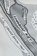 | Details | Allyn, Rube | 1960 |
| Allyn's Fishing Map 2E Sarasota Bay |
|
Allyn, Rube |
|
| 1960 |
| LOC:61 |
| $135.00 | Allyn--Rube | Allyn-s-Fishing-Map-2E-Sarasota-Bay | Original Rube Allyn's Authentic Fishing Map (ca. 1960), for Sarasota Bay, Florida. Key features include Sister Key, Sleepy Lagoon, Dream Island, Buttonwood Harbor, Longboat Key, Sarasota, Ringling Isles and Big Sarasota Pass.
<br></br>
Map # 2E. Ca. 1960. Copyright Rube Allyn, St. Petersburg, Florida. Lithographed by MacDonald, Tampa. |
| 4933 | 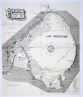 | Details | Allyn, Rube | 1960 |
| Scarce Rube Allyns Authentic Fishing Map Lake Okeechobee Florida |
|
Allyn, Rube |
|
| 1960 |
| LOC:61 |
| $0.00 | Allyn--Rube | Scarce-Rube-Allyns-Authentic-Fishing-Map-Lake-Okeechobee-Florida | SOLD
<br></br>
Scarce, presumed first edition of Rube Allyn's Authentic Fishing Map (ca. 1960), for Lake Okeechobee, Florida. Drawn by Erland M. Larson. Published by the Great Outdoors Association, Pier 63, Central Basin, St, Petersburg, Fla. Price when issued 25 cents.
<br/><br/>
Includes Moore Haven, Clewiston, Lake Harbor, Pahokee. Much interesting local detail such as Peanut Shirling's Camp, Dewey's Camp, Fish Eating Creek, Bill Johnson's Fishing Camp, Slim's Fish Camp, Port Mayaca, and the cross-state waterway. |
| 6708 |  | Details | Allyn, Rube | 1960 |
| Allyns Fishing Map Lemon Bay 2G |
|
Allyn, Rube |
|
| 1960 |
| LOC:0 |
| $175.00 | Allyn--Rube | Allyns-Fishing-Map-Lemon-Bay-2G | DESCRIPTION: Original Rube Allyn's Authentic Fishing Map for Lemon Bay, Florida (ca. 1960). Drawn by Charlie Allyn and Barbara Hagerman. Points of interest include Gasparilla Sound, Coral Creek, Little Gasparillo Pass, Stump Pass, Stanford's Fishing Resort, Manasota Key, Englewood, and Alligator Creek.
<br></br>
Map # 2G. ca. 1960. Copyright Rube Allyn, St Petersburg, Florida. Great Outdoors Association. Pier 63, Central Basin, St. Petersburg, Florida. |
| 6709 | 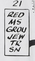 | Details | Allyn, Rube | 1960 |
| Rube Allyn's Fishing Map Little Sarasota Bay Venice Florida 2F |
|
Allyn, Rube |
|
| 1960 |
| LOC:0 |
| $175.00 | Allyn--Rube | Rube-Allyn-s-Fishing-Map-Little-Sarasota-Bay-Venice-Florida-2F | DESCRIPTION: Original Rube Allyn's Authentic Fishing Map for the Little Sarasota Bay / Venice, Florida area. Key locations and features Allyn has noted include: Casey Key, Vamo, Osprey, Sarasota Beach, Midnight Pass, Tamiami Trail, Lyons Bay, and Roberts Bay. Perhaps the most interesting feature is a rock shelf (avg. depth 28 feet) that sinuously snakes its way just offshore the beach. Chart #2F.
<br></br>
Copyright Rube Allyn, St. Petersburg, Florida |
| 6707 | 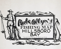 | Details | Allyn, Rube | 1960 |
| Allyns Fishing Map Hillsboro Bay 2B Tarpon |
|
Allyn, Rube |
|
| 1960 |
| LOC:0 |
| $165.00 | Allyn--Rube | Allyns-Fishing-Map-Hillsboro-Bay-2B-Tarpon | DESCRIPTION: Original Rube Allyn's Authentic Fishing Map (ca. 1960), for lower Hillsboro Bay south of St. Petersburg, Florida. Features include McKay Bay, Black Point, Gadsden Point, Coon Hammock Creek, the Kitchen, East Tampa, Alafia River, and Delaney Creek. Shows an astounding number of locations to catch Tarpon!
<br></br>
Map # 2B. ca. 1960. Copyright Rube Allyn, St. Petersburg, Florida. Research by Doc Howe. Drawn by Jack Meyer. |
| 5032 | 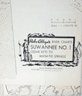 | Details | Allyn, Rube | 1960 |
| Lot of six river charts Suwannee River and Withlacoochee |
|
Allyn, Rube |
|
| 1960 |
| LOC:0 |
| $0.00 | Allyn--Rube | Lot-of-six-river-charts-Suwannee-River-and-Withlacoochee | SOLD
<br></br>
Lot of six Rube Allyn's river charts for the Withlacoochee and Suwanee Rivers copyrighted by the Great Outdoors Association ca. 1960's.
<br></br>
As described on the envelope covering the exterior of the chart, Allyn sold his Withlacoochee and Suwanee River charts in sets of three and four sheets:
<div class="indenttextblock">
"<b>Suwannee River</b>, with 210 miles of romance and delight, completely charted in four large maps. … Beautiful springs, delightful camping places. At some villages, modern air-conditioned motels."
<ul style="list-style-type: circle;">
<li>S1- Cedar Keys to Manatee Springs/Oldtown</li>
<li>S2 - Manatee Springs/Oldtown to Branford</li>
<li>S3 - Branford to White Springs</li>
</ul>
"<b>Withlacoochee River</b>, one of Florida's most beautiful and fishable streams. … 14 fishing resorts accurately placed and more that 100 secret fishing spots revealed."
<ul style="list-style-type: circle;">
<li>W1- Gulf of Mexico to Backwaters (Gulf to Dunnellon) </li>
<li>W2 - Dunnellon to Panasoffkee (Dunnellon to Inverness)</li>
<li>W3 - Panasoffkee to Headwaters (Inverness to St. Catherine)</li>
</ul>
</div>
Note: Chart titles on the Withlacoochee River Series differ between the folders and the charts.
</div> |
| 6710 | 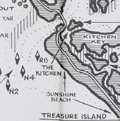 | Details | Allyn, Rube | 1960 |
| Rube Allyn's Fishing Map Boca Ciega Bay Clearwater 1B |
|
Allyn, Rube |
|
| 1960 |
| LOC:0 |
| $175.00 | Allyn--Rube | Rube-Allyn-s-Fishing-Map-Boca-Ciega-Bay-Clearwater-1B | DESCRIPTION: Original Rube Allyn's Authentic Fishing Map ca. 1960. for upper Boca Ciega Bay and Gulf Beaches. Locations and features that Allyn chose to include are: Clearwater Harbor, Reddington Beach, Upper Boca Ciega Bay, Madeira Beach, Long Bayou, Jungle Estates, Sunset Beach, Devil's Elbow, Blind Pass, and St. John's Pass.
<br></br>
Copyright Rube Allyn, St. Petersburg, Florida. Chart #1B. Drawn by Jack Meyer. |
| 6328 | 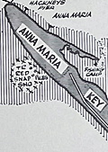 | Details | Allyn, Rube | 1960 |
| Allyns Fishing Map 2C Lower Tampa Bay |
|
Allyn, Rube |
|
| 1960 |
| LOC:61 |
| $0.00 | Allyn--Rube | Allyns-Fishing-Map-2C-Lower-Tampa-Bay | SOLD<br></br>
DESCRIPTION: Original Rube Allyn's Authentic Fishing Map (ca. 1960), for lower Tampa Bay - Manatee River, Florida. Key features include Terra Ceia Bay, Snead Island, McGill Island, Anna Maria Key, Perico Island, Palma Sola Bay, Bradenton Beach, Cortez, the Holmes Yacht Basin and the northern-most point of Sister Key.
<br></br>
Map # 2C. Ca. 1960. |