British Admiralty Hydrographical Office
1920

Large Antique Chart of The Florida Keys

United States - East Coast - Florida Reefs - Lower Matacumbe Cay to Boca Grande Cay from the United States Coast Survey 1851 - 1908.

DESCRIPTION: Fine antique British Admiralty sea chart with cartographic coverage of the islands of the Florida Keys. Hydrographic data on this early 1866 British navigational chart extend past Key West. Though updated to 1920, this scarce survivor retains the appearance of a 19th-century British copperplate-engraved nautical chart, a visual charm more recent charts do not generally possess.

An inset diagram shows an example navigational beacon, made of iron, 36 feet in height and carrying an identifying letter within a moveable vane. These beacons, or day marks, delineated the southern boundary of the Florida Keys. The accompanying note states:

Florida keys navigational beacons (day marks) 
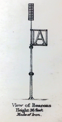
"The Beacons marking the outer Florida Reefs are distinguished by Letter or Numbers in the vane which each carries, commencing off Key West and proceeding in alphabetical or numerical order toward Cape Florida. With the exceptions of that American Shoal which is brown and that on Fowey Rock which is black, the Beacons are all painted white. These beacons are likely to be washed away."


Manuscript notations in pencil from a previous owner record eight of the beacons as "damaged."

This chart of Lower Matacumbe Cay to Boca Grande Cay should be treasured by anyone with interests in fishing, sailing, or boating in the Florida Keys.

After U.S. Coast Survey charts from the last half of the 19th century. First published by the British Admiralty on July 18, 1866, with several editions and later corrections after, the last correction in 1920. Originally sold by J.D. Potter, agents, London. Chart no. 1098.

CREATOR: British Admiralty Hydrographical Office

PUBLICATION DATE: 1920

GEOGRAPHIC AREA: United States

BODY OF WATER: Caribbean Sea

CONDITION: Very Good.  Clean and bright. No holes, tears or other issues. Manuscript notations in pencil regarding the status of local navigation beacons.

COLORING: None except lighthouses in orange.

ENGRAVER: J & C Walker

SIZE: 25 " x 38 "

ITEM PHYSICAL LOCATION: 61

PRICE: $1375

ADD TO CART


This web site provides security by Rapid SSL


Use Visa credit card Use Discover credit card
Use MasterCardcredit card Use American Express credit card

Similar items: