| | Thumbnail | | Creator | Date | Title / Author / Date / Location | Price | | | Description |
| 6616 | 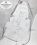 | Details | British Admiralty Hydrographical Office | |
| Original Admiralty harbor chart for Port Barcelona |
|
British Admiralty Hydrographical Office |
|
|
| LOC:57 |
| $900.00 | British-Admiralty-Hydrographical-Office | Original-Admiralty-harbor-chart-for-Port-Barcelona | Original 1873 British Admiralty harbor chart of the Port of Barcelona, Spain, issued as chart no. 1195. Published at the Admiralty in London under the superintendence of Rear Admiral G. H. Richards, Hydrographer, and based on Spanish surveys conducted in 1871. The chart was engraved by Edward Weller and drawn by H. Stafford. As with other Admiralty productions of the period, it reflects standardized hydrographic practices intended for practical navigation rather than decorative presentation.<br><br>
The chart details the harbor and immediate coastal approaches with extensive soundings, shoreline configuration, and port infrastructure as they existed in the early 1870s. Labeled features include Montjuich, the Arsenal, Punta de la Paz, Vista Alegro, Huertas de S. Beltran, and Barceloneta. Harbor works and alterations are shown, including the Old Mole light, noted as scheduled for demolition, documenting changes underway in the port’s configuration. The sheet captures Barcelona at a moment of transition, as the harbor was being adapted to accommodate increased commercial and industrial maritime traffic.<br><br>
British Admiralty charts were produced for active use by naval and commercial mariners and were regularly updated as surveys improved. As a result, early impressions such as this example are increasingly scarce in original form. This chart is of interest for its documentation of 19th century harbor engineering, Mediterranean navigation, and the development of Barcelona as a major port city, and it fits well within collections focused on nautical cartography, port plans, or European maritime history. |
| 841 |  | Details | British Admiralty Hydrographical Office | 1849 |
| Nautical chart of China Between Taizhou and Wenzhou |
|
British Admiralty Hydrographical Office |
|
| 1849 |
| LOC:0 |
| $475.00 | British-Admiralty-Hydrographical-Office | Nautical-chart-of-China-Between-Taizhou-and-Wenzhou | British sea chart of the East coast of China, in Zhejiang province, from Taizhou ( "Taichow" ) to Wenzhou ( "Wan-Chew Foo" ), China. Coverage on this old nautical chart includes the Dachen Islands, consisting of 29 islands, rocks, and islets to the east of Taizhou. Also shown East of Wenzhou in the East China Sea is Dongtou, an island district in China composed of 168 islands.
<br></br>
Published from London by the British Admiralty, originally in 1843. This edition was produced in August 1849. Sold by J.D. Potter 31 Poultry and 11 King Street, Tower Hill. |
| 4969 | 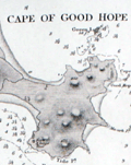 | Details | British Admiralty Hydrographical Office | 1849 |
| Antique Admiralty Chart Eastern China Chelang To Chauan |
|
British Admiralty Hydrographical Office |
|
| 1849 |
| LOC:59 |
| $575.00 | British-Admiralty-Hydrographical-Office | Antique-Admiralty-Chart-Eastern-China-Chelang-To-Chauan | Antique nautical chart of China coast. First edition of a scarce Admiralty nautical chart of the East coast of China. <b>"Sheet III - Eastern Coast from Chelang Pt. To Chauan Bay"</b> .
<br></br>
Includes an area north of Hong Kong from Jieshi Bay ( "Hie-Che-Chin Bay" ) trending northeast past Nan'ao ( "Namoa" ) Island to Zhao'an Bay ( "Chauan Bay" ). In 2007, off the coast of Nan'ao island local fishermen discovered a shipwreck, Nan'ao One, considered to be the first late Ming dynasty ship ever found; likely the only one from the reign of Emperor Wanli (1573–1620) that China has discovered.
<br></br>
Manuscript pencil and ink course plot lines and position plots. Published September 12, 1849 by the Hydrographic Agency of the British Admiralty. Number 1963. Four detailed inset port/harbor plans:
<div class="indenttextblocksingle">
<ul style="list-style-type: circle;">
<li>Chino Bay</li>
<li>Cupchi Point</li>
<li>Cape of Good Hope</li>
<li>Hai Mun</li>
</ul>
</div>
Based on a survey conducted by Royal Navy Captain R. Collinson in 1845. Published by the Admiralty September 12, 1849. Engraved by J & C Walker. Chart #1963. |
| 949 |  | Details | British Admiralty Hydrographical Office | 1857 |
| Antique Chart of the Northern Coast of New Zealand from Hokianga to Tutukaka |
|
British Admiralty Hydrographical Office |
|
| 1857 |
| LOC:59 |
| $1,500.00 | British-Admiralty-Hydrographical-Office | Antique-Chart-of-the-Northern-Coast-of-New-Zealand-from-Hokianga-to-Tutukaka | Scarce antique hydrographic chart of the northern coastline of <b>New Zealand</b> from the Hokianga Harbour to Tutukaka, in the province of Auckland. Among the earliest available artifacts from the first full hydrographic survey of New Zealand during 1849-1855. At upper left corner are the uninhabited Three-Kings Islands about 35 miles northwest of Cape Reinga, the northernmost point of New Zealand's North Island. With large insets of Parenga Renga Harbour and Ohora River and Bay.
<br></br>
Based on surveys of <b>Captain J. L. Stokes</b> and Commander R. Drury of the HMS Acheron and the Pandora respectively. Among his many accomplishments, Stokes served as assistant surveyor aboard the <b>HMS Beagle</b> during its well-known voyage around the world with Charles Darwin in 1833-36. Hooker's brief biography of Stokes includes a portrait and this entry:
<div class="indenttextblock"> "Stokes, John Lort (1812-86) - Royal Navy officer and hydrographer, was chosen by Beaufort, the British Hydrographer for the 'Great New Zealand Survey.' Stokes had joined the navy as a ‘volunteer first class’ in 1824 and by 1843, he was an experienced surveyor with the rank of commander. In 1846, he was promoted to captain and in the following year was given command of HMS Acheron. Between 1848 and 1855, Stokes surveyed extensively in New Zealand waters. With Drury’s surveys they were the most complete investigations carried out to that time. Over forty-five New Zealand charts were published in the years following Stokes’ and Drury’s surveys. Some of Stokes' data were also incorporated in maps published by Arrowsmith." (Hooker, Brian. Dictionary of New Zealand Map-Makers.<a href="http://zeehaen.tripod.com/dictionary_map_m/dictionary_part_c_bh.htm " target="_blank">Internet</a>)</div>
</br>
Contains a seller's circular black ink overstamp from "Reading and Wellbank, Chart and Nautical Booksellers, 366 George Street." Number 2525. |
| 800 | 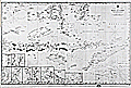 | Details | British Admiralty Hydrographical Office | 1864 |
| Chart of South Sulawesi and Lesser Sunda Islands from Bali to Timor |
|
British Admiralty Hydrographical Office |
|
| 1864 |
| LOC:59 |
| $1,075.00 | British-Admiralty-Hydrographical-Office | Chart-of-South-Sulawesi-and-Lesser-Sunda-Islands-from-Bali-to-Timor | Antique British Admiralty navigational chart of a major portion of the Lesser Sunda Islands. Coverage includes the Strait of Macassar, Gulf of Boni, Banda Sea, Arafura Sea, the lower portion of Sulawesi, Indonesia ( Celebes ) , and the islands of Bali ( Baly ), Lombok, Sombawa, Comodo, Flores, and Timor. <br></br>
This fine large chart Includes 9 inset detailed charts at bottom left: Anapanam Bay, Laboaen Tring Bay, Pampang Bay, Pidioe Bay, Taliwang Bay, Bima Bay, Sapie Bay, Nangamessie Bay, Koepang Bay.
<br></br>
Published at the Hydrographic Office of the Admiralty August 4, 1851 with last corrections in 1864. Originally sold by J.D. Potter, London. Bottom margin includes a small pasted seller's label from Australia: "Blundell & Ford, Admiralty Chart Agents. Melbourne". Number 2073. |
| 5158 |  | Details | British Admiralty Hydrographical Office | 1864 |
| Antique Chart of the Bay and Harbor at Trincomalee Trincomalie Ceylon Sri Lanka |
|
British Admiralty Hydrographical Office |
|
| 1864 |
| LOC:59 |
| $400.00 | British-Admiralty-Hydrographical-Office | Antique-Chart-of-the-Bay-and-Harbor-at-Trincomalee-Trincomalie-Ceylon-Sri-Lanka | Chart of the Bay and Harbor of Trincomalee, an important port in Sri Lanka, which has been called the finest in the Indian Ocean. Published by the Hydrographical Office of the British Admiralty on July 3rd, 1834. Last corrected 1864.
<br></br>
The numerous key features on the map include Flagstaff Point, Fort Frederick, Lake Tamblegam, Great Bay, Norway Point, Elephant Ridge, Round Island, and Great Saber Island. Numerous soundings and marked anchorages.
<br></br>
In 1834 the Nautical Magazine described the chart:
<div class="indenttextblocksingle">
"Double-elephant. Includes the whole of Back Bay on the north and Great Bay on the south with Foul Point. It gives a complete view of the whole of the indented coast by which the harbour of Trincomalee is surrounded."
</div>
(Vol. 3, p. 690)
<br></br>
The same issue noted a similar sized but larger scale chart only of the "Harbour of Trincomalee" by Owen, Cannon, and Loring. |
| 840 | 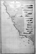 | Details | British Admiralty Hydrographical Office | 1868 |
| Antique Admiralty Nautical Chart of San Diego Bay to Cape Mendocino California |
|
British Admiralty Hydrographical Office |
|
| 1868 |
| LOC:63 |
| $3,000.00 | British-Admiralty-Hydrographical-Office | Antique-Admiralty-Nautical-Chart-of-San-Diego-Bay-to-Cape-Mendocino-California | Large antique British Admiralty sea chart of the California coast extending from Humboldt Bay and Cape Mendocino in the North, trending southeast past San Francisco Bay and Monterey Bay to San Diego, California. Lighthouses are picked out with red dots highlighted in yellow.
<br></br>
Contains fifteen coastal elevation views with some of the most stunning coastal scenery in the world including the Big Sur area. These carefully engraved coastal elevations include: Cape Mendocino, Point Arena, Pt. Reyes, Entrance to San Francisco Bay, Point Piedras, Point Ano Nuevo, South Farallon Lighthouse, Point Sur, Moro Rock, Point Arguilla, Pt. Conception, Point Loma, Catalina Harbor, and the Point of Boundary between the United States and Mexico.
<br></br>
First published by the Admiralty from London in April 1858 under the superintendence of Royal Navy Hydrographer Captain Washington. This edition of the scarce nautical chart was printed with corrections to July 1868.
<br></br>
Sold by J.D. Potter Agent for The Admiralty, 31 Poultry and 11 King Street Tower Hill. |
| 581 | 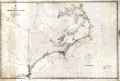 | Details | British Admiralty Hydrographical Office | 1871 |
| Albemarle Sound to Cape Fear |
|
British Admiralty Hydrographical Office |
|
| 1871 |
| LOC:0 |
| $720.00 | British-Admiralty-Hydrographical-Office | Albemarle-Sound-to-Cape-Fear | Antique, rolled, British Admiralty sea chart of the coast of North Carolina ( NC ). This lithographed chart, although issued by the Admiralty Hydrographic Office in London, is based on work by the U.S. Coast Survey ca. 1847 and is dated to the edition of 1871. Numerous soundings, aids to navigation, inlets, rivers, and hazards are noted.
<br></br>
Coverage extends from Currick Sound / Elizabeth City, N.C. south to Little River Inlet at the border with South Carolina. A sampling of the many noted points of interest include: Cape Fear, Cape Lookout, Cape Hatteras, Albemarle Sound, Pamplico Sound, Core Sound, Holden Beach, Neuse River, Ocracoke Inlet and Ocracoke Island, Beaufort, Wilmington, Elizabeth City, and at the very bottom, Frying Pan Shoals.
<br></br>
This antique sea chart was first published at the Admiralty in London on November 30, 1861 under the superintendence of Captain Washington, R.N.: F.R.S. Hydrographer. Sold by J.D. Potter, agent for the Admiralty Charts. 31 Poultry and 11 King Street Tower Hill (London). Number 2826. Price when issued was half a crown. |
| 281 | 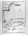 | Details | British Admiralty Hydrographical Office | 1871 |
| Bays of Pampatar and Port Moreno, and Port of Laguna Grande del Obispo |
|
British Admiralty Hydrographical Office |
|
| 1871 |
| LOC:5 |
| $95.00 | British-Admiralty-Hydrographical-Office | Bays-of-Pampatar-and-Port-Moreno--and-Port-of-Laguna-Grande-del-Obispo | Lithographed antique nautical chart shows Port Moreno and the castle and city of Pampatar, Venezuela near the easternmost point on the island of Margarita- Punta Ballena. Also, Laguna Madre del Obispo, a bay on the northern coast of the Golfo de Cariaco in the state of Sucre, Venezuela. Originally published in 1826 with corrections in 1871, these two nautical charts on a single page are copied from earlier copperplate engraved works prepared by the Spanish Direccion Hidrografia ca 1809.<BR> </BR>
<a style="color:#9BAFCB" rel="nofollow" href="/Creator/direccion-hidrografia">See all inventory by the Direccion Hidrografia: </a>
<BR> </BR>Stamp of "Hydrographical Office". Price: sixpence. Notation at bottom: "Sold by J.D. Potter, Agent for the sale of Admiralty Charts, 31 Poultry & 11 King Street, Tower Hill". |
| 282 |  | Details | British Admiralty Hydrographical Office | 1871 |
| The Bay of Corsarios and the Port of Turiamo from Spanish printed plans. |
|
British Admiralty Hydrographical Office |
|
| 1871 |
| LOC:5 |
| $85.00 | British-Admiralty-Hydrographical-Office | The-Bay-of-Corsarios-and-the-Port-of-Turiamo-from-Spanish-printed-plans- | 19th century lithographed antique nautical chart shows two coastal areas in Venezuela: The Bay of Corsarios and The Port of Turiamo. Originally published in 1827 with corrections in 1871, these two charts on a single page are copied from earlier copperplate engraved works prepared by the Spanish Direccion Hidrografia.<BR> </BR>
<a style="color:#9BAFCB" rel="nofollow" href="/Creator/direccion-hidrografia">See all antique nautical charts by the Direccion Hidrografia: </a>
<BR> </BR>Stamp of "Hydrographical Office". Price: sixpence. Notation at bottom: "Sold by J.D. Potter, Agent for the sale of Admiralty Charts, 31 Poultry & 11 King Street, Tower Hill". |
| 1041 |  | Details | British Admiralty Hydrographical Office | 1871 |
| 1871 Chart of the Outer Banks, Albemarle Sound to Cape Fear |
|
British Admiralty Hydrographical Office |
|
| 1871 |
| LOC:53 |
| $1,600.00 | British-Admiralty-Hydrographical-Office | 1871-Chart-of-the-Outer-Banks--Albemarle-Sound-to-Cape-Fear | Antique, British Admiralty sea chart of the North Carolina Outer Banks in outstanding condition. Although issued by the Admiralty Hydrographic Office in London, this chart is based on work by the U.S. Coast Survey ca. 1847 and is dated with corrections to May, 1871. Numerous soundings, aids to navigation, inlets, rivers, and hazards are noted, particularly in Onslow Bay, Raleigh Bay, and the coastal inlets.
<br></br>
Coverage extends from Currick Sound / Elizabeth City, N.C. south to Little River Inlet at the border with South Carolina. A sampling of the many noted points of interest include: Cape Fear, Cape Lookout, Cape Hatteras, Albemarle Sound, Pamplico Sound, Core Sound, Holden Beach, Neuse River, Ocracoke Inlet and Ocracoke Island, Beaufort, Wilmington, Elizabeth City, and at the very bottom, Frying Pan Shoals.
<br></br>
This antique sea chart was first published at the Admiralty in London on November 30, 1861 under the superintendence of Captain Washington, R.N.: F.R.S. Hydrographer. Sold by J.D. Potter, agent for the Admiralty Charts. 31 Poultry and 11 King Street Tower Hill (London). Number 267. |
| 944 |  | Details | British Admiralty Hydrographical Office | 1872 |
| Antique British sea chart of Mobile Bay and Dauphin Island |
|
British Admiralty Hydrographical Office |
|
| 1872 |
| LOC:53 |
| $1,350.00 | British-Admiralty-Hydrographical-Office | Antique-British-sea-chart-of-Mobile-Bay-and-Dauphin-Island | Attractive, scarce antique British nautical chart of Mobile Bay, Alabama and Dauphin ("Dauphine") Island. With Isle aux Herbes and Bayou la Batre. On <b>Dauphin Island</b> the noted features include Fort Gaines, Heron Bayou, Second Bayou, Gravline Bay, Bayou Aloe, Chitgae Point, Drury Pass, Little (and Big) Margaret Pass, and Bayou Matagua. Opposite Dauphin Island, Bonsecours Bay, Mobile Point, Pilot Town and Fort Morgan are noted with a separate quarters building and three large umbrella pines, e.g. "West Umbrella tree" that are referenced as range markers in the sailing directions of Blunt's contemporary "American Coast Pilot" (Blunt, Edmund M. 21st ed. 1867. pp. 399-400.)
<br></br>
This is a large rolled nautical chart on heavy paper. Not the folded preliminary survey on weak paper that is often found in Reports to Congress.
<br></br>
North end of Mobile Bay includes a street plan of Mobile, Alabama with nearby features including Pole Cat Bay, Chicasaw Bayou, Chacaloochee Bay, Apalachee River, and Minetta Bay. Good detail of the east bay including Weeks Bay, Blakely River, Point Clear, <b>D'Olives Bay, D'Olives Creek</b>, (<i>near present-day Daphne, Al.</i> ), Alabama City, and Newport.
<br></br>
Inset sailing directions carry this warning:
<div class="indenttextblock"> "Caution: Sand and Pelican Is. are increasing in length and Pelican Channel is getting narrower every year… Pelican Bay is available only for vessels drawing less than 12 feet water. The entrance from outside should not be attempted without a pilot, nor can the state on the main channel be considered as permanent."</div>
</br>
Scale 1/80,000. Number 2344.
<br></br>
Publisher's attribution reads :<div class="indenttextblock"> "London, Published at the Admiralty 12th March 1862 under the Superintendence of Captn. Washington R.N.F.R.S. Hydrographer. Corrections Feb 72. Sold by J.D. Potter Agent for the Admiralty Charts 31 Poultry and 11 King Street Tower Hill."</div> |
| 4757 | 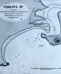 | Details | British Admiralty Hydrographical Office | 1873 |
| Antique Chart of New Zealand from Otago to the Mataura River and Ruapuke Island |
|
British Admiralty Hydrographical Office |
|
| 1873 |
| LOC:59 |
| $1,100.00 | British-Admiralty-Hydrographical-Office | Antique-Chart-of-New-Zealand-from-Otago-to-the-Mataura-River-and-Ruapuke-Island | Two scarce antique charts of New Zealand on one sheet: 1) Middle Island, Otago to Mataura River (with large scale insets of Waikawa Harbor and of Catlin River), and 2) Foveaux Strait, Ruapuke Island.
<br></br>
Based on surveys of <b>Captain J. L. Stokes</b> and officers of the HMS Acheron during 1849-1851. Among his many accomplishments, Stokes served as assistant surveyor aboard the <b>HMS Beagle</b> during its well-known voyage around the world with Charles Darwin in 1833-36. Hooker's brief biography of Stokes includes a portrait and this entry:
<div class="indenttextblock"> "Stokes, John Lort (1812-86) - Royal Navy officer and hydrographer, was chosen by Beaufort, the British Hydrographer for the 'Great New Zealand Survey.' Stokes had joined the navy as a ‘volunteer first class’ in 1824 and by 1843, he was an experienced surveyor with the rank of commander. In 1846, he was promoted to captain and in the following year was given command of HMS Acheron. Between 1848 and 1855, Stokes surveyed extensively in New Zealand waters. With Drury’s surveys they were the most complete investigations carried out to that time. Over forty-five New Zealand charts were published in the years following Stokes’ and Drury’s surveys. Some of Stokes' data were also incorporated in maps published by Arrowsmith." (Hooker, Brian. Dictionary of New Zealand Map-Makers.<a href="http://zeehaen.tripod.com/dictionary_map_m/dictionary_part_c_bh.htm " target="_blank">Internet</a>)</div> |
| 862 |  | Details | British Admiralty Hydrographical Office | 1873 |
| Antique Chart of the Bill of Portland to St Albans Head, England |
|
British Admiralty Hydrographical Office |
|
| 1873 |
| LOC:0 |
| $265.00 | British-Admiralty-Hydrographical-Office | Antique-Chart-of-the-Bill-of-Portland-to-St-Albans-Head--England | Old antique linen-backed sea chart of the Portland Bill, a promontory on the Isle of Portland, in southern Dorset, England extending eastward to the rocky headland of St. Albans Head. Two lighthouses are shown highlighted in yellow, an upper and a lower lighthouse. Key features identified by name on the chart include Portland Ledge, the Shambles, Weymouth, Melcombe Regis, White Nore, East and West Lulworth, Kimeridge, St. Alban's Head, and Endcombe House.
<br></br>
The surrounding coast of Portland, namely Portland Bill and Chesil Beach, have been notorious for the many vessels that became shipwrecked in the area over the centuries. The dangerous coastline, which features a stony shingle beach, shallow reefs and the Shambles sandbank, was proven more hazardous due to the strong tidal rapid known as the Portland Race. The Portland race, with short choppy waves and eddies, is caused by the constriction of the tidal flow between the Bill and the Shambles.
<br></br>
Published by the Admiralty March 5, 1873 under the Superintendence of Rear Admiral G.H. Richards, Hydrographer. Contains a pasted label for the seller, James Wyld, Geographer to the Queen.
<br></br>
See also a
<a href="http://www.rarecharts.com/ShowDetail/Creator/British-Admiralty-Hydrographical-Office/Title/Antique-Chart-of-the-Dorset-Coast-with-Weymouth-and-Portland--England/863 " target="_blank">similar large-scale chart of Weymouth and Portland.</a> |
| 863 |  | Details | British Admiralty Hydrographical Office | 1873 |
| Antique Chart of the Dorset Coast with Weymouth and Portland, England |
|
British Admiralty Hydrographical Office |
|
| 1873 |
| LOC:0 |
| $285.00 | British-Admiralty-Hydrographical-Office | Antique-Chart-of-the-Dorset-Coast-with-Weymouth-and-Portland--England | Large-scale detailed antique linen-backed sea chart of Weymouth, the West Bay, the Shambles, Portland Harbour, and Portland Bill, a promontory on the Isle of Portland, in southern Dorset, England. Two lighthouses are shown highlighted in yellow, an high light and a lower lighthouse. Three attractive inset elevation views at bottom include: Anvil Point, Wyke Regis Church, and the Small Chalk Pit.
<br></br>
Portland Bill and the nearby area have been notorious for the many vessels that became shipwrecked in the area over the centuries. The dangerous coastline, which features a stony shingle beach, shallow reefs and the Shambles sandbank, was proven more hazardous due to the strong tidal rapid known as the Portland Race. The Portland race, with short choppy waves and eddies, is caused by the constriction of the tidal flow between the Bill and the Shambles.
<br></br>
Key features identified by name on the chart include Portland Ledge, Chesilton, a merchant ships anchorage, the man of war anchorage, the Shambles, Weymouth, Melcombe Regis, Jordan Hill, Ringsted Ledge, and Holworth Cliff.
<br></br>
Published by the Admiralty May 9, 1855 with corrections to 1873. Contains a pasted label for the seller, J. Wyld, Geographer to the Queen. Scale 1/18,200.
<br></br>
See also a similar small-scale chart covering a
<a href="http://www.rarecharts.com/ShowDetail/Creator/British-Admiralty-Hydrographical-Office/Title/Antique-Chart-of-the-Bill-of-Portland-to-St-Albans-Head--England/862 " target="_blank">wider area of the Dorset coast to St. Alban's Head.</a> |
| 860 |  | Details | British Admiralty Hydrographical Office | 1874 |
| Antique linen-backed chart of the English Channel and Bristol Channel |
|
British Admiralty Hydrographical Office |
|
| 1874 |
| LOC:0 |
| $350.00 | British-Admiralty-Hydrographical-Office | Antique-linen-backed-chart-of-the-English-Channel-and-Bristol-Channel | Old antique nautical chart of the English Channel first published by the British Admiralty on July 1, 1859. This edition bears cumulative corrections to 1874. Coverage extends from Finisterre, France and Ushant ( "Ile de Ouessant" ) past the English county of Cornwall, past Wales, to the southeast coast of Ireland including Wexford and Waterford. Key features include Brest, France, the island of Guernsey, Cornwall, The Scilly Isles, the Bristol Channel, Saint George's Channel, and Cardigan Bay.
<br></br>
Original seller's attribution to J.D. Potter is pasted over with an addendum: "Sold by J. Wyld, Geographer to Her Majesty. 457 Strand." With the oval logo of the Hydrographical Service. Chart # 2675b. |
| 5153 | 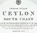 | Details | British Admiralty Hydrographical Office | 1875 |
| Antique Admiralty Chart of South Ceylon (Sri Lanka) |
|
British Admiralty Hydrographical Office |
|
| 1875 |
| LOC:59 |
| $1,150.00 | British-Admiralty-Hydrographical-Office | Antique-Admiralty-Chart-of-South-Ceylon-(Sri-Lanka) | Large nautical chart of south Sri Lanka (Ceylon) published in 1858 with last corrections in 1875. This scarce antique navigation chart was based on surveys by T.H. Twynam in 1833. The chart includes three finely engraved coastal elevation views- Colombo from the Outer Anchorage, Galle Light House, and Lion Peak.
side of Gan Island.
<br></br>
Five inset large-scale harbor charts include:
<div class="indenttextblocksingle">
<ul style="list-style-type: circle;">
<li>Colombo</li>
<li>Dodandowe Bay</li>
<li>Kirinde Road</li>
<li>Belligam Bay</li>
<li>Point de Galle Harbour</li>
</ul>
</div>
The sailing directions on this old chart make for interesting reading. For Belligam Bay the Admiralty recommended: "Keep the Cocoanut Trees on the point inside Woody Island well open until you bring Ruane Rock on with the east side of Gan Island."
<br></br>
The chart is titled: "Indian Ocean. Ceylon, South Coast. Surveyed by Mr. T.H. Twynam, Master Attendant at Point de Galle, 1833, with additions by Mr. James Steuart, Master, R.N., and E.I. Company's Officers."
<br></br>
Published by the Hydrographic Office of the Admiralty January 1858 by Captain Washington. Engraved by J and C. Walker. Sold by J.D. Potter, London. |
| 4976 | 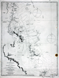 | Details | British Admiralty Hydrographical Office | 1875 |
| Admiralty chart of Australia Magnetic Island to Double Point Barrier Reefs |
|
British Admiralty Hydrographical Office |
|
| 1875 |
| LOC:59 |
| $1,300.00 | British-Admiralty-Hydrographical-Office | Admiralty-chart-of-Australia-Magnetic-Island-to-Double-Point-Barrier-Reefs | Antique British Admiralty navigation chart of the East Coast of Australia, sheet 15 in a series. Coverage includes Moresby River, Mourliyan Harbor, the King Reefs, Bay Hill, Dunk Island, Kennedy Bay, Rockingham Bay, Goold Island, Port Hinchinbrook, Bishops Peak, Halifax Bay.
<br></br>
Map clearly features several sources of fresh water, low mangrove swamps, sugar plantations, and much of the inner Australian Barrier Reef. Includes a large poorly mapped region of the east Australian coast noted as: "Low wooded coast and apparently much occupied by lagoons".
<br></br>
Colophon: Published according to an Act of Parliament at the Hydrographic Office of the Admiralty March 20th, 1855. Sold by J.D. Potter. |
| 953 | 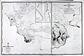 | Details | British Admiralty Hydrographical Office | 1875 |
| Antique Chart of Bluff Harbor and Invercargill, New Zealand |
|
British Admiralty Hydrographical Office |
|
| 1875 |
| LOC:59 |
| $1,375.00 | British-Admiralty-Hydrographical-Office | Antique-Chart-of-Bluff-Harbor-and-Invercargill---New-Zealand | Large British Hydrographic charts of <b>Bluff Harbor</b> on the southern coast of South Island, <b>New Zealand</b>. Located across the Foveaux Strait from Bluff is Stewart Island (not shown). Bluff is one of the oldest areas on New Zealand where Europeans established a presence. The first European settlers arrived around 1823. A second, enlarged scale chart is at right of "Entrance of Awarua or Bluff Harbour."
<br></br>
With an inset chart "Continuation of New River to <b>Invercargill</b> / surveyed by Mr J.T. Thomson, 1856." Invercargill is the southernmost and westernmost sizeable city in New Zealand, and among cities with a population of over 50,000 is the 5th southernmost city in the world. (<a href="https://en.wikipedia.org/wiki/Southernmost_settlements " target="_blank">Internet</a>)
<br></br>
The chart denotes the location of Maori settlements including: "Old village of Te Whero"; "Owi Village"; "Omawi Village"; and a "Freshwater Spot".
<b></b>
At upper right, sailing directions for Bluff Harbor from Mr. Thomson, Harbor Master in 1865 includes instructions for boarding a pilot:
<div class="indenttextblock"> "Vessels from the Eastward, taking the passage between Dog Island and the sands, should give the island a half mile berth and steer about West for Look-out Point till Starling Pt. bears North, then steer in to pass about 1 1/2 cables length [ a cable length is about 100 fathoms or 600 feet] off Starling Pt. leaving the red buoys on the starboard hand and when abreast of it the pilot boat will be seen.
</div>
</br>
Manuscript marginal notations (sailing directions) in French and two manuscript additions of bouys to the chart suggest that this chart was actually used for navigation in that area.
<br></br>
Based on surveys of <b>Captain J. L. Stokes</b> of the HMS Acheron. Stokes served as assistant surveyor aboard the <b>HMS Beagle</b> during its well-known voyage around the world with Charles Darwin in 1833-36. |
| 1468 |  | Details | British Admiralty Hydrographical Office | 1875 |
| Gulfs of St. Vincent and Spencer Southern Sheet 2 |
|
British Admiralty Hydrographical Office |
|
| 1875 |
| LOC:59 |
| $1,300.00 | British-Admiralty-Hydrographical-Office | Gulfs-of-St--Vincent-and-Spencer-Southern-Sheet-2 | A special chart in excellent condition for the collector of Australian maps. This antique British Admiralty sea chart contains both the town of Adelaide, Australia AND also bears the blue sellers over-stamp of A.E. Sawtell a chart-seller from Port Adelaide, Australia from at least 1874 to 1901 or later (See <a href="https://www.rarecharts.com/ShowDetail/Creator/Sawtell--Alfred-E-/Title/Sawtells-Nautical-Almanac/209" target="_blank">Sawtell's 1874 nautical almanac</a> from our archives.).
<br></br>
The southern sheet of a large 2-sheet sea chart, unjoined. Last correction in 1875. Covers the southern portion of St. Vincent Gulf and Spencer Gulf with Investigator Strait, the MacDonnell Peninsula, Kangaroo island, Wedge Island, Thistle Island, Encounter Bay, Aldinga Bay, and Holdfast Bay . Shows the nascent town of Adelaide, Australia with several neighboring villages including: Plympton, Kensington, Beaumont, Norwood, and Glenelg.
<br></br>
Three inset coastal profile views taken from various directions including one view that is labeled: "Outline of the Land on the East side of St. Vincent Gulf as seen from a vessel's deck when running up Troubridge Lighthouse bearing N.W. by W 1/2 W. 9 1/2 miles."
<br></br>
Publisher's attribution reads: "Published at the Admiralty 17 Aug. 1874 under the Superintendance of Captain F.J. Evans R.N., C.B, F.R.S. Hydrographer ." Number 2389b.
<br></br>
Alfred E. Sawtell, was a seller of nautical charts and instruments from Port Adelaide Australia. Sawtell published a Nautical Almanac in 1874 containing an ephemeris, tide tables, sailing directions for Australian ports, pilotage dues, a 7 page list of Australian vessels and their tonnage; and ships regulations for bathing, sanitation and gunpowder. In that almanac the back cover advertisement describes A.E. Sawtell as: "Chronometer, Watchmaker, Nautical Optician, Chart and Nautical Bookseller". |
| 1469 | 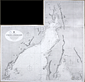 | Details | British Admiralty Hydrographical Office | 1875 |
| Gulfs of St. Vincent and Spencer Northern Sheet 1 |
|
British Admiralty Hydrographical Office |
|
| 1875 |
| LOC:59 |
| $1,350.00 | British-Admiralty-Hydrographical-Office | Gulfs-of-St--Vincent-and-Spencer-Northern-Sheet-1 | A very special chart in excellent condition for the collector of Australian maps. The northern sheet of a large 2-sheet sea chart, covering Port Adelaide and sold by a nautical chart-seller from Port Adelaide.
<br></br>
This antique British Admiralty sea chart contains both the town of Port Adelaide, Australia AND also bears the blue sellers over-stamp of A.E. Sawtell a chart-seller from Port Adelaide, Australia from at least 1874 to 1901 or later. (See <a href="https://www.rarecharts.com/ShowDetail/Creator/Sawtell--Alfred-E-/Title/Sawtells-Nautical-Almanac/209" target="_blank">Sawtell's 1874 nautical almanac</a> from our archives.) Chart is In fine condition. North sheet of a large 2-sheet sea chart, unjoined but with a wing-sheet, an extension to the chart as issued covering northern-most Spencer Gulf miles past Port Augusta, Australia.
<br></br>
Covers the northern portion of St. Vincent Gulf and Spencer Gulf.
<br></br>Bottom sheet (2) publisher's attribution reads: "Published at the Admiralty 17 Aug. 1874 under the Superintendance of Captain F.J. Evans R.N., C.B, F.R.S. Hydrographer ." Number 2389a.
<br></br>
Bottom sheet (2) seller's information: "Sold by J.D. Potter Agent for sale of the Admiralty, 31 Poultry and 11 King Street, Tower Hill."
<br></br>
Alfred E. Sawtell, was a seller of nautical charts and instruments from Port Adelaide Australia. Sawtell published a Nautical Almanac in 1874 containing an ephemeris, tide tables, sailing directions for Australian ports, pilotage dues, a 7 page list of Australian vessels and their tonnage; and ships regulations for bathing, sanitation and gunpowder. In that almanac the back cover advertisement describes A.E. Sawtell as: "Chronometer, Watchmaker, Nautical Optician, Chart and Nautical Bookseller". An enclosed stock list included nautical books, charts, chronometers and "transparent dipping needle and plain compass cards all sizes". |
| 578 |  | Details | British Admiralty Hydrographical Office | 1875 |
| Savannah River and Calibogue Sound |
|
British Admiralty Hydrographical Office |
|
| 1875 |
| LOC:53 |
| $1,250.00 | British-Admiralty-Hydrographical-Office | Savannah-River-and-Calibogue-Sound | A large antique British Admiralty nautical chart of the Savannah River area, Georgia first issued in 1855 and corrected in 1862. This lithographed chart, although issued by the Admiralty Hydrographic Office in London, is based on work by the U.S. Coast Survey and is dated at bottom left to the edition of 1875. Numerous soundings, aids to navigation, and hazards are noted.
<br></br>
Named features on this antique nautical chart include Hilton Head Island, Daufuskie ( Daufuski ) Island, Tybee Island, Wilmington Island, McQueens Island, Cockspur Island, Argyle Island, Onslow Island, Hutchnison and Fig Islands; the towns/settlements of Savannah, Wassaw, Bonaventure; fortresses of Fort Jackson, Fort Pulaski, and Fort Thunderbolt; and the locations of Opossum Point, Stoddards House, Mongens House, and Spanish Wells.
<br></br>
The chart was first published at the Admiralty in London on July 1, 1861 under the superintendence of Captain Washington, R.N.: F.R.S. Hydrographer. Sold by J.D. Potter, agent for the Admiralty Charts. 31 Poultry and 11 King Street Tower Hill (London). Number 2826. Price when issued was half a crown. |
| 3653 | 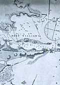 | Details | British Admiralty Hydrographical Office | 1875 |
| Scarce British chart of East Falkland Island and Stanley Harbor |
|
British Admiralty Hydrographical Office |
|
| 1875 |
| LOC:51 |
| $3,200.00 | British-Admiralty-Hydrographical-Office | Scarce-British-chart-of-East-Falkland-Island-and-Stanley-Harbor | Scarce, perhaps very rare, British hydrographic chart of the Stanley Harbor, Port William, and Port Harriett in the Falkland Islands. The chart is based on observations taken during the surveys of Captain Robert Fitzroy (1805 -1865) during the second voyage of the HMS Beagle. Includes an elevation view of the Cape Pembroke lighthouse.
<br></br>
A search of OCLC/WorldCat revealed that no libraries were found to hold the chart and no examples are online for sale. One instance of a sale of this chart is recorded in the Antique Map Price Record, in 2006.
<br></br>
Originally published by an act of Parliament in 1847. This chart was printed with corrections and additions in 1875 from London. With the seller's oval blue ink stamp of Phillip, Son & Nephew, Agents for the Admiralty Charts, 49 South Castle Street, Liverpool. Last correction 1875.
<br></br>
Robert Fitzroy studied at the Royal Naval College. His first command was the famed sloop HMS Beagle. During the Beagle's second voyage (Dec. 1831 - Oct. 1836) Fitzroy surveyed the coasts of Patagonia, Tierra del Fuego and the Straits of Magellan, accompanied by the naturalist Charles Darwin, whose later publications were largely based on discoveries and observations made during this voyage. Darwin and Fitzroy shared quarters aboard the Beagle and their discussions aboard ship are believed to have greatly influenced Darwin.
<br></br>
The main purpose of the expedition was to conduct a hydrographic survey of the coasts of the southern part of South America. The voyages of the Beagle established FitzRoy as an excellent navigator, a sound surveyor and a man of science. Suffering from depression, Fitzroy took his own life with a straight razor in 1865. Today a settlement on East Falkland is named in honor of Robert Fitzroy.
<br></br>
Chart no. 1774. |
| 1329 | 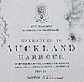 | Details | British Admiralty Hydrographical Office | 1876 |
| Antique chart of Auckland Harbor, New Zealand |
|
British Admiralty Hydrographical Office |
|
| 1876 |
| LOC:0 |
| $0.00 | British-Admiralty-Hydrographical-Office | Antique-chart-of-Auckland-Harbor--New-Zealand | SOLD
<br></br>
Scarce antique British nautical chart of the entrances to Auckland Harbour, New Zealand based on the <b>first complete hydrographic survey of New Zealand waters</b> which was conducted by Captain J.L. Stokes, Commander B. Drury and the Officers of H.M.S. Acheron and Pandora 1849-1855. This edition contains corrections up to 1876. Chart number 1896.
<br></br>
This detailed chart of Auckland, New Zealand is based on surveys of <b>Captain J. L. Stokes</b> and Commander R. Drury of the HMS Acheron and the Pandora respectively. Among his many accomplishments, Stokes served as assistant surveyor aboard the <b>HMS Beagle</b> during its well-known voyage around the world with Charles Darwin in 1833-36. Hooker's brief biography of Stokes includes a portrait and this entry:
<div class="indenttextblock"> "Stokes, John Lort (1812-86) - Royal Navy officer and hydrographer, was chosen by Beaufort, the British Hydrographer for the 'Great New Zealand Survey.' Stokes had joined the navy as a ‘volunteer first class’ in 1824 and by 1843, he was an experienced surveyor with the rank of commander. In 1846, he was promoted to captain and in the following year was given command of HMS Acheron. Between 1848 and 1855, Stokes surveyed extensively in New Zealand waters. With Drury’s surveys they were the most complete investigations carried out to that time. Over forty-five New Zealand charts were published in the years following Stokes’ and Drury’s surveys. Some of Stokes' data were also incorporated in maps published by Arrowsmith." (Hooker, Brian. Dictionary of New Zealand Map-Makers.<a href="http://zeehaen.tripod.com/dictionary_map_m/dictionary_part_c_bh.htm " target="_blank">Internet</a>)</div>
</BR>
See also: ( Hargreaves, R.P. "Nineteenth Century Hydrographic Charts: A Preliminary Checklist." <a href="https://evols.library.manoa.hawaii.edu/bitstream/10524/55278/1/v27n07_1964_Hargreaves.pdf" target="_blank">Online</a>.) |
| 647 |  | Details | British Admiralty Hydrographical Office | 1879 |
| Coquimbo Bay and Port Herradura, Chile |
|
British Admiralty Hydrographical Office |
|
| 1879 |
| LOC:67 |
| $175.00 | British-Admiralty-Hydrographical-Office | Coquimbo-Bay-and-Port-Herradura--Chile | British Admiralty chart of the Coquimbo Peninsula in north-central Chile, just south of the tourist destination of La Serena. Detailed topography and hydrography with numerous soundings about the town and bay of Coquimbo, Chile and the adjacent Port Herradura. Based on the survey by Captain Richard C. Mayne, R.N. and the officers of H.M.S. Nassau, 1868.
<br></br>
Features include Whale Rock, the town of Herradura (in ruins), Cuyacan, the English cemetery, a Chilean cemetery, Signal Hill, Tortuga Point with lighthouse, and four smelting works. Railroad lines are located both to Serena and to Panucillo.
<br></br>
Originally published at the Admiralty, London on May 1, 1869 and corrected in August 1873. Sold by J.D. Potter. 31 Poultry and 11 King Street, Tower Hill. |
| 3652 |  | Details | British Admiralty Hydrographical Office | 1880 |
| Scarce British chart of the Falklands from Fitzroy, Robinson, and Sullivan |
|
British Admiralty Hydrographical Office |
|
| 1880 |
| LOC:51 |
| $4,000.00 | British-Admiralty-Hydrographical-Office | Scarce-British-chart-of-the-Falklands-from-Fitzroy--Robinson--and-Sullivan | Scarce, perhaps very rare, British hydrographic chart of the Falkland Islands based on observations taken during the surveys of Captain Robert Fitzroy (1805 -1865) and others. Includes ten coastal elevation views of the Falklands as seen from sea. Published by an act of Parliament in 1841 this chart was printed with corrections and additions in 1880. With the seller's oval blue ink stamp of Phillip, Son & Nephew, Agents for the Admiralty Charts, 49 South Castle Street, Liverpool.
<br></br>
No holdings of this chart are found in OCLC, no examples are online for sale. No records in AMPR.
<br></br>
Robert Fitzroy studied at the Royal Naval College. His first command was the famed sloop HMS Beagle. During the Beagle's second voyage (Dec. 1831 - Oct. 1836) Fitzroy surveyed the coasts of Patagonia, Tierra del Fuego and the Straits of Magellan, accompanied by the naturalist Charles Darwin, whose later publications were largely based on discoveries and observations made during this voyage. Darwin and Fitzroy shared quarters aboard the Beagle and their discussions aboard ship are believed to have greatly influenced Darwin.
<br></br>
The main purpose of the expedition was to conduct a hydrographic survey of the coasts of the southern part of South America. The voyages of the Beagle established FitzRoy as an excellent navigator, a sound surveyor and a man of science. Suffering from depression, Fitzroy took his own life with a straight razor in 1865. Today a settlement on East Falkland is named in honor of Robert Fitzroy.
<br></br>
Chart no. 1354. |
| 5151 |  | Details | British Admiralty Hydrographical Office | 1882 |
| Chart of South America West Coast Callao Lima Pisco Bay |
|
British Admiralty Hydrographical Office |
|
| 1882 |
| LOC:0 |
| $350.00 | British-Admiralty-Hydrographical-Office | Chart-of-South-America-West-Coast-Callao-Lima-Pisco-Bay | Antique engraved sea chart of the west coast of Peru based on explorations by the ship Beagle. Coverage includes a wide stretch of coast that includes Callao (the port for Lima, Peru), and Pisco Bay with the Ballestas Islands (Ballista). Last corrections 1882. These charts are increasingly scarce.
<br></br>
This fine chart contains seven engraved inset coastal elevation views with features that include Huacho Head, Hormigas Rocks, Salinas Point, Calavera Head, and Mount Lechuza. Two inset harbors charts: Ancon Bay and Chincha Hills.
<br></br>
Published by the Admiralty September, 15th 1840. Sold by J. D. Potter. Engraved by J. & C. Walker. Chart number 1323.
<br></br>
Faint blue stamped sellers label for Phillip, Son & Nephew, Liverpool. |
| 577 |  | Details | British Admiralty Hydrographical Office | 1882 |
| China Eastern Coast Hieshan Isles to the Yang-Tse-Kiang |
|
British Admiralty Hydrographical Office |
|
| 1882 |
| LOC:0 |
| $1,100.00 | British-Admiralty-Hydrographical-Office | China-Eastern-Coast-Hieshan-Isles-to-the-Yang-Tse-Kiang | Rolled British Admiralty sea chart of China's Eastern coast first published October 3, 1849. Coverage includes Shanghai, China, the mouth of the Yangtze River and part of the Poo-Tung (Putuo) Peninsula south to the Chusan (Zhoushan) islands. This edition of the antique nautical chart reflects the latest corrections made in 1882. With an attached extension at left. The chart is comprised of one large lithographed sheet conjoined with two smaller sheets when published.
<br></br>
Sold by J.D. Potter agent for the Admiralty Charts. 31 Poultry and 11 King Street Tower Hill (London). Number 1199. Price when issued was three shillings. |
| 5023 |  | Details | British Admiralty Hydrographical Office | 1883 |
| Scarce large Admiralty nautical chart of the Entrance to Pensacola Bay Florida |
|
British Admiralty Hydrographical Office |
|
| 1883 |
| LOC:0 |
| $0.00 | British-Admiralty-Hydrographical-Office | Scarce-large-Admiralty-nautical-chart-of-the-Entrance-to-Pensacola-Bay-Florida | SOLD<br></br>
Scarce large rolled sea chart on heavy paper of the entrance to Pensacola Bay, Florida (after the U.S. Coast Survey 1857) published at the Admiralty on May 30, 1861 under the superintendence of Captain Washington, R.N. Last correction 1883. No folds.
<br></br>
Not a preliminary chart. Full-size nautical charts on heavy paper of the Entrance to Pensacola Bay are very scarce, whether by the U.S. Coast Survey or the Admiralty.
<br></br>
Sold by J.D. Potter. Engraved by J & C Walker. Chart number 2820. |
| 2556 |  | Details | British Admiralty Hydrographical Office | 1886 |
| 19th Century Chart of San Francisco Harbour by the British Admiralty |
|
British Admiralty Hydrographical Office |
|
| 1886 |
| LOC:0 |
| $0.00 | British-Admiralty-Hydrographical-Office | 19th-Century-Chart-of-San-Francisco-Harbour-by-the-British-Admiralty | SOLD <br></br>
Large and striking antique chart of San Francisco Bay and harbor by the British Admiralty. This scarce old chart is after the U.S. Coast Survey chart of the area. Coverage includes San Francisco and surrounding area as it existed in 1877, reprinted in 1886 with corrections. Top of chart contains two views of the entrance to the bay from the south and the north showing both steam and sail-powered vessels underway and at anchor.
<BR> </BR>
Noted points of interest include Oakland, Sausalito, Alcatraz Island, Yerba Buena Island, the Presidio, Mission de Delores, Table Mountain, San Leandro, Brooklyn, Alameda, and of course the Golden Gate (no bridge).
<BR> </BR>
London. Published at the Admiralty 1st Feb. 1883 Under the Superintendence of Captain Sir Frederic J. Evans R.N., K.C.B., F.R.S. Hydrographer.
<BR> </BR>
With the British Admiralty logo. Number 591. Last corrections 1886. |
| 5335 | 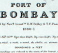 | Details | British Admiralty Hydrographical Office | 1886 |
| Antique British Chart Port of Bombay India |
|
British Admiralty Hydrographical Office |
|
| 1886 |
| LOC:9 |
| $1,650.00 | British-Admiralty-Hydrographical-Office | Antique-British-Chart-Port-of-Bombay-India | Rare antique British harbor chart of the port of Bombay (Mumbai), India by the British Admiralty Hydrographical Office. This fine engraved chart covers the Port of Bombay on the east side of the southern peninsula from Prince's Dock (built in 1885) at the north down just past Sassoon Dock in the south.
<br></br>
At left of the chart is a table of data about the wet docks and graving docks including the width of the entrance and the depth over the sill. Six informative profile views of local aids-to-navigation include :
<div class="indenttextblocksingle">
<ul style="list-style-type: circle;">
<li>The Malet Shelf Beacon</li>
<li>North Channel Beacon</li>
<li>South Channel Beacon</li>
<li>North Kolaba (Colaba) Beacon</li>
<li>South Kolaba (Colaba) Beacon</li>
<li>Sunk Rock Lighthouse</li>
</ul>
</div>
Some of the key features and locations noted at the Port of Bombay are:
<div class="indenttextblocksingle">
<ul style="list-style-type: circle;">
<li>Great Indian Peninsula Railway lines and yard</li>
<li>Bombay, Baroda & Central India rail lines and Kolaba RY station</li>
<li>The dockyard</li>
<li>Sailor's home</li>
<li>Church Gate RY station</li>
<li>Fort district</li>
<li>Castle [Castle da Orta]</li>
<li>Ice house</li>
<li>Carnac, Nicol, and Musjid basins</li>
<li>The Pilot Pier</li>
</ul>
</div>
Published at the Admiralty 14th January 1885 under the Superintendence of Captain W. J. L. Wharton, R.N. Hydrographer. Number 655. Sold by J. D. Potter, London. Last corrections in 1886. Engraved by Davies and Company. |
| 5187 |  | Details | British Admiralty Hydrographical Office | 1895 |
| Atlas of 12 monthly current charts Indian Ocean 1895 |
|
British Admiralty Hydrographical Office |
|
| 1895 |
| LOC:0 |
| $0.00 | British-Admiralty-Hydrographical-Office | Atlas-of-12-monthly-current-charts-Indian-Ocean-1895 | SOLD<br></br>
Rare hydrographic atlas published by the British Admiralty with twelve charts (January-December) of the Indian Ocean showing the prevailing current direction and velocity for each month. The charts were all based on data collected as far back as 1830. Each chart was published at different dates in 1895 and 1896 under the Superintendence of Admiral Wharton, Hydrographer. Price when issued was ten shillings. |
| 766 |  | Details | British Admiralty Hydrographical Office | 1898 |
| Antique Chart for coastal Mozambique Africa south of the Zambezi River |
|
British Admiralty Hydrographical Office |
|
| 1898 |
| LOC:0 |
| $0.00 | British-Admiralty-Hydrographical-Office | Antique-Chart-for-coastal-Mozambique-Africa-south-of-the-Zambezi-River | SOLD
<br></br>
Antique 1898 British Admiralty navigation chart of Mozambique, Africa, until 1975 a Portuguese colony. Coverage includes the east coast of Africa from Maputo, Delagoa Bay (Maputo Bay) northward past the Zavalla River, Cape Corrientes, Innamban River, Burra, Bazaruto Island, Moromone Bay, Beira, and terminating at the mouths of the Zambezi River.
<br></br>
Near the Zavalla River about 3 miles offshore are noted two wrecks: the Courland and the Countess of Carnarvon. The Countess of Carnarvon was a steamer, owned by the British South African Company that briefly attained fame for her role in a gun-running operation during February 1891. She was seized by the Portuguese government after steaming up the Limpopo River and landing rifles in Portuguese territory. After protestations by the British government she was released. [1]
<br></br>
With purple inked stamp from the charts' owner with the vessel's name: Vapor Jose Gallart, Barcelona. The steamship Ramon Alonso R. was originally launched in 1898 by British shipbuilder Elder and Dempsey. She was sold in 1901 to Catalan shipping firm A. Folch y Cia who renamed her the 'Jose Gallart'. [2]
<br></br>
<img src="http://lh3.ggpht.com/-si2Cuv4gu2M/VEpxAyFRhYI/AAAAAAAAQqk/MvQQPEuoluA/s0/Vapor%252520JOSE%252520GALLART%252520en%252520el%252520dique%252520flotante%252520y%252520deponente%252520de%252520Barcelona.%252520Memoria%252520del%252520puerto%252520de%252520Barcelona.%252520Fecha%252520indeterminada.jpg" alt="Steamship JOSE GALLART in drydock ca. 1901" width="345" alt="French steamship Jose Gallart circa 1898">
<br></br>
[1] Galbraith, John S. Crown and Charter: The Early Years of the British South Africa Company; http://books.google.com .
<br>
[2] Vida Maritima. http://vidamaritima.com/2007/08/ramon-alonso-ramos-charcos/ |
| 765 |  | Details | British Admiralty Hydrographical Office | 1898 |
| Antique Chart for the Coast of Tunisia Africa |
|
British Admiralty Hydrographical Office |
|
| 1898 |
| LOC:0 |
| $175.00 | British-Admiralty-Hydrographical-Office | Antique-Chart-for-the-Coast-of-Tunisia-Africa | Antique British Admiralty working navigation chart for the Coast of Tunisia, Africa from the Fratelli Rocks west of Bizert ( Benzert ) extending southeastward past Tunis, Cape Carthage, Cap Bon, the Gulf of Hammamet, Monastir, and terminating near Mahedia. Detailed soundings and contour lines. Unlike many nautical charts this example provides good topographical detail extending well into the interior especially in the area of the Cape Bon peninsula.
<br></br>
With a purple inked stamp from the charts' owner with the vessel's name and home port: 'Vapor Jose Gallart, Barcelona' . The steamship Ramon Alonso R. was originally launched in 1898 by British shipbuilder Elder and Dempsey. She was sold in 1901 to Catalan shipping firm A. Folch y Cia who renamed her the 'Jose Gallart'. (Source: Vida Maritima.) |
| 4792 |  | Details | British Admiralty Hydrographical Office | 1899 |
| Antique British Chart of Gran Canaria island |
|
British Admiralty Hydrographical Office |
|
| 1899 |
| LOC:54 |
| $275.00 | British-Admiralty-Hydrographical-Office | Antique-British-Chart-of-Gran-Canaria-island | Antique, used 1899 British Admiralty nautical chart of the island of Gran Canaria one of the Canary Islands of Spain, lying off the coast of northwest Africa. In 1900 the population of the entire group of Canary Islands was estimated at almost 360,000 individuals with the main exports consisting of wine, spirits, potatoes, tobacco, bananas, and cochineal.
<br></br>
Based on a survey by Lieutenant William Arlett (d. 1839) of the Royal Navy aboard the ship Aetna. With several manuscript notations and course plots in pencil, attesting to a well-used life aboard ship. Arlett's notes on his survey of the Canary Islands describes his impression of the island and the survey method of triangulation, employed across the entire island :<div class="indenttextblock">
"On the 14th December we arrived at Port la Luz in the island of La Gran Canaria, the Great Canary. This island is nearly circular and about twenty-four miles in diameter, or seventy-five in circumference. Its is mountainous, and the coast, gereally speaking, precipitous. "
…<br></br>
"A base having been measured, a triangulation was carried completely round the island, whence the soundings as well as the coast line were laid down trigonometrically.
" (Arlett, W. The Journal of the Royal Geographic Society of London. Volume 6. 1836.)</div>
<BR/>
Highly detailed topography in the interior of the island. Includes these key features: Las Palmas, the capital city; la Luz Harbor; Ayrenaga Bay; Tenefe Point; Romeral Castle (Castillo); and Morro Colchas point with its lighthouse. With an inset plan of Maspalomas Anchorage and two inset coastal elevation views. Lighthouses are highlighted in yellow.
<br></br>
The chart was first published at the Admiralty in London on June 26th, 1848. Sold by J.D. Potter, agent for sale of Admiralty Charts, 14-5 Minories. Verso with MS chart collation number "5b". Number 1869. Numerous large and small corrections, the last correction in 1899. |
| 5185 | 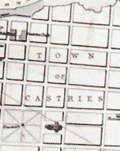 | Details | British Admiralty Hydrographical Office | 1903 |
| Island of St. Lucia Port Castries |
|
British Admiralty Hydrographical Office |
|
| 1903 |
| LOC:51 |
| $575.00 | British-Admiralty-Hydrographical-Office | Island-of-St--Lucia-Port-Castries | Antique chart of Port Castries in the French West Indies. Castries is the capital and a major port on the island of St. Lucia in the Caribbean.
<br></br>
Published at the Admiralty on November 13, 1865. Chart number 499. |
| 4772 |  | Details | British Admiralty Hydrographical Office | 1906 |
| Singapore Road |
|
British Admiralty Hydrographical Office |
|
| 1906 |
| LOC:0 |
| $0.00 | British-Admiralty-Hydrographical-Office | Singapore-Road | SOLD
<br></br>
Rare early engraved 1906 antique nautical chart of Singapore Road or anchorage surrounding the Singapore River. No copy of the Singapore Road 1906 edition is recorded in AMPR or elsewhere online. Engraved by the well-used engravers J & C Walker.
<br></br>
First published at the Admiralty January 7th, 1865 under the superintendence of Captain G.H. Richards Royal Navy Hydrographer. This, the result of the 4th major correction, is the edition of February 7, 1906 based largely after the work of John William Reed and officers aboard the H.M.S. Rifleman in 1864. Sold by J.D. Potter Agent for the Admiralty, London. |
| 4760 |  | Details | British Admiralty Hydrographical Office | 1907 |
| China From Hailing Island to Hong Kong with Macao |
|
British Admiralty Hydrographical Office |
|
| 1907 |
| LOC:59 |
| $0.00 | British-Admiralty-Hydrographical-Office | China-From-Hailing-Island-to-Hong-Kong-with-Macao | SOLD<br></br>
Fine, very scarce original British Admiralty nautical chart of the coast of China west of <b>Hong Kong</b> by Belcher. Published in 1853 (1907), this fine sea chart was engraved by J & C Walker.
<br></br>
Coverage extends from Hailing Island (Hui Ling Island) past Macau and ends with Hong Kong. Includes three detailed inset charts and plans: Macao Harbour, Namo Harbour, and Hui-Ling (Hailing) Harbour.
<br></br>
First published Sept 4, 1853 according to an Act of Parliament at the Hydrographic Office of the Admiralty. Corrections to 1883 by Captain J. Calder of the Chinese Gunboat Sui-Tsing. Numerous minor corrections, with the last small correction in 1907. This chart 2212 is a later edition of Belcher's Admiralty chart 1625 "Mongchow to Hong Kong".
<br></br>
Verso with several MS chart collation numbers including a stenciled "143". Sold by J.D. Potter Agent for Admiralty Charts, 146 Minories. Chart number 2212. Two sheets joined; one vertical fold.
<br></br>
Admiral Sir Edward Belcher (1799 – 1877) was born in Nova Scotia and at age 13 enlisted as a volunteer in the British Royal Navy. Belcher went on to a long career as a British naval officer, hydrographer, and explorer. Belcher is credited with producing the first detailed map of Hong Kong in 1841, one year before the island was handed over to Britain. |
| 3608 | 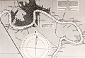 | Details | British Admiralty Hydrographical Office | 1908 |
| Large Chart of Mississippi River from the Passes to New Orleans |
|
British Admiralty Hydrographical Office |
|
| 1908 |
| LOC:53 |
| $1,050.00 | British-Admiralty-Hydrographical-Office | Large-Chart-of-Mississippi-River-from-the-Passes-to-New-Orleans | Fine British Admiralty chart of the Mississippi River from Nine Mile Point above New Orleans, south to the Mississippi River passes. Bold dark lithographed print retains the cartographic look and style of late 19th century Admiralty charts.
<br></br>
New Orleans shown with the mid-city area only partially built out. Virtually no development on the West Bank. Well before the bridges were built.
<br></br>
Later edition of a British Admiralty chart first engraved and published from London in 1903, and updated with corrections after that. From the copper plate engraved by Davies & Co. Sold by J.D. Potter. Dated to 1908 by the note regarding magnetic variation.
<br></br>
Logo of the British Hydrographical Office at top of the title block. Published from London on Nov 6, 1903 . Number 3382. |
| 4751 |  | Details | British Admiralty Hydrographical Office | 1912 |
| Antique chart of Galveston Bay to the San Bernard River, Texas |
|
British Admiralty Hydrographical Office |
|
| 1912 |
| LOC:63 |
| $525.00 | British-Admiralty-Hydrographical-Office | Antique-chart-of-Galveston-Bay-to-the-San-Bernard-River--Texas | A fine early 20th-century British Admiralty chart of <B>Galveston Bay, Bolivar Peninsula, San Bernard River, and Galveston Island, Texas</b> made long before the massive development we see today. This chart, published by the Hydrographic Office is based on existing U.S. Coast Survey charts of the area from 1855 - 1858.
<br></br>
Coverage includes all of Galveston Bay extending as far north as San Jacinto Bay and Turtle Bay. Numerous named features include Quintana, Bastrop Bayou, San Luis Pass, Texas City, Clear Lake, the Trinity River, Fort Anahuac, and Bolivar Point. Shows existing and proposed dredged navigation channels. Inset large-scale charts for Clopper's Bar and Redfish Bar.
<br></br>
Published at the Admiralty under the Superintendence of Captn. Washington R.N. F.R.S. Hydrographer. Sold by J.D. Potter Agent for the Admiralty. Numerous small and large corrections; the last correction being in 1912.
MS notations on verso identifying the chart collation number "68" in large red letters. Number 2831. |
| 4834 |  | Details | British Admiralty Hydrographical Office | 1912 |
| China Sea Banka Strait to Singapore |
|
British Admiralty Hydrographical Office |
|
| 1912 |
| LOC:59 |
| $1,500.00 | British-Admiralty-Hydrographical-Office | China-Sea-Banka-Strait-to-Singapore | Fine original British Admiralty Chart of the South China Sea with Singapore featured prominently at top left. Singapore, at the south end of the Malay peninsula, was made a British colony in 1946 and in 1965 became an independent republic. Singapore is separated from the Malay Peninsula to the north by the Johor Strait. At the time of last correction (1912) the chart showed only two navigational lights on the island of Singapore.
<br></br>
South of Singapore, across the Singapore Strait, lie the Riau Archipelago (Kepulauan Riau) including the islands of Batam, Bintan, Rempang, Galang, and numerous smaller islands.
<br></br>
A scarce and desirable chart.
<br></br>
Moving south down the East Coast of Sumatra past the islands of Batam, Bintan, Ligga, and Singkep, the chart ends at the Banka Strait and Banka Island.
<br></br>
Verso with manuscript index labeling in several locations. |
| 4822 | 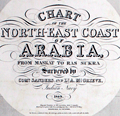 | Details | British Admiralty Hydrographical Office | 1912 |
| Antique nautical chart of Arabia from Muscat to Ras Sukra, Oman |
|
British Admiralty Hydrographical Office |
|
| 1912 |
| LOC:54 |
| $3,750.00 | British-Admiralty-Hydrographical-Office | Antique-nautical-chart-of-Arabia-from-Muscat-to-Ras-Sukra--Oman | Chart of Oman on the eastern Arabian coast by Commander J.P. Sanders and Lieutenant Albany Grieve of the <b>Indian Navy</b> aboard the ship <b>Palinurus</b>. The survey was significant in that it resulted in connecting the surveys of the Persian Gulf to the surveys of the Red Sea.
<div class="indenttextblocksingle">
"… and thus the coastline, from Cape Comorin to Ras Gulwainee on the African continent, had been minutely examined and laid down by the officers of the Indian Navy." [1]
</div>
</br>
Includes 6 inset port and harbor charts from other British surveys as well as surveys of the French Government:
<div class="indenttextblocksingle">
<ul style="list-style-type: circle;">
<li>Bandar Jissa</li>
<li>Sur Anchorage</li>
<li>Bandar Khairan</li>
<li>Madraka Anchorage</li>
<li>Khor Jarama</li>
<li>Dar Sait Anchorage</li>
</ul>
</div>
</div>
[1] Low, Charles Rathbone. History of the Indian Navy (1613-1863). V2. London, 1877. p. 215.
</div> |
| 5327 | 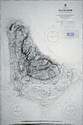 | Details | British Admiralty Hydrographical Office | 1917 |
| Admiralty sea chart of Barbados Bajan |
|
British Admiralty Hydrographical Office |
|
| 1917 |
| LOC:51 |
| $1,250.00 | British-Admiralty-Hydrographical-Office | Admiralty-sea-chart-of-Barbados-Bajan | Fine engraved antique nautical chart of the Island of Barbados first published by the British Admiralty in 1869 from a survey by Staff Commander J. Parsons, R.N. assisted by Navigating Lieut. H. R. Harris & G. Stanley R. N. This edition of the Barbados chart was published at the Admiralty on Feb. 26, 1873. This issue contains the latest corrections from 1917.
<br></br>
Two inset profile views of Barbados at bottom. Chart number 2485.
<br></br>
With two ink stamps for chart sellers from South America: Thomas Bruzzone e Hijos, Buenos Aires and Rodolfo Bosenberg, Libros y Mapas Maritimos [Buenos Aires]. |
| 5152 | 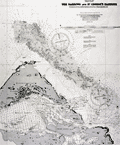 | Details | British Admiralty Hydrographical Office | 1918 |
| Chart of eastern Bermuda Islands St. Georges |
|
British Admiralty Hydrographical Office |
|
| 1918 |
| LOC:54 |
| $450.00 | British-Admiralty-Hydrographical-Office | Chart-of-eastern-Bermuda-Islands-St--Georges | Antique engraved British Admiralty chart of the eastern Bermuda Islands-- St. George's Island, Paget Island, Smith's Island, and St. David's Island. Shows roads and buildings then existing in St. George's Town and the channel dredged into St, George's Harbor in 1916 and 1917. Edition of February, 1918.
<br></br>
This navigational chart of Bermuda was published in July 1897, but 1918, under the superintendence of Rear Admiral W. J. L. Wharton. Engraved by Davies and Company. Sold by J.D. Potter, London.
<br></br>
Chart number 1315. |
| 3607 |  | Details | British Admiralty Hydrographical Office | 1918 |
| Large Chart of Charleston Harbor, South Carolina |
|
British Admiralty Hydrographical Office |
|
| 1918 |
| LOC:53 |
| $1,250.00 | British-Admiralty-Hydrographical-Office | Large-Chart-of-Charleston-Harbor--South-Carolina | Fine British Admiralty chart of Charleston Harbor, South Carolina based on U.S.C.G.S. charts to 1914. This edition with corrections to 1918. Named features Include Folly Island, Morris Island, James Island, Sullivan Island, and the Isle of Palms. From the copper plate engraved by J & C Walker.
<br></br>
Later edition of a British Admiralty chart first engraved and published from London in 1869, and updated with corrections after that.
<br></br>
Bold dark lithographed print retains the cartographic look and style of the late 19th century. Logo of the British Hydrographical Office at top of the title block. Published from London on April 1, 1869 . Number 2324 |
| 4894 |  | Details | British Admiralty Hydrographical Office | 1918 |
| Antique Chart of Nantucket Sound and Eastern Approaches |
|
British Admiralty Hydrographical Office |
|
| 1918 |
| LOC:53 |
| $1,350.00 | British-Admiralty-Hydrographical-Office | Antique-Chart-of-Nantucket-Sound-and-Eastern-Approaches | Fine engraved British Admiralty navigation chart (1918) of Nantucket Island, Nantucket Sound and portions of "America" (what Nantucket locals seem to call the mainland U.S.A.). On Nantucket Island the chart shows some of the primary landmarks that guide visitors today: the Sankaty Head Light, Brant Point Lighthouse, Siasconset, Maddaket Harbor and more.
<br></br>
The chart, engraved by Edward Weller, is titled "United States East Coast. Nantucket Sound and Eastern Approaches. From United States Government Charts to 1914."
<br></br>
Notable locations shown on the mainland include Hyannis, Lewis Bay, Monomoy Island, Dennis Port, Harwich Port, and Chatham. Edition of February, 1916 with last corrections in 1918.
<br></br>
London. Published at the Admiralty, January 28, 1896 under the superintendence of Rear Admiral W.J.L. Wharton. C.B., F.R.S. Hydrographer. Sold by J.D. Potter. Chart number 2489. |
| 5080 |  | Details | British Admiralty Hydrographical Office | 1918 |
| Oman Maskat and Al Matrah surveyed by Lieut A.W. Stiffe |
|
British Admiralty Hydrographical Office |
|
| 1918 |
| LOC:66 |
| $2,500.00 | British-Admiralty-Hydrographical-Office | Oman-Maskat-and-Al-Matrah-surveyed-by-Lieut-A-W--Stiffe | Scarce and truly fascinating British Admiralty chart of the coast of Oman showing Matrah (Mutrah) Bay and Maskat Cove with a plan of the town of Maskat, now Muscat the port capital of Oman. Includes two fine inset elevation views: View of Maskat from the Cove and a view of the larger area from Ras Maskat to Doha. Only one sale of the chart is recorded in the Antique Map Price Record- by the esteemed dealer Jonathan Potter in 1985 (those were the days).
<br></br>
Published first by the Admiralty May 27, 1862 under the superintendence of Rear Admiral Washington, Hydrographer. This is the edition of 1917 with last correction in 1918. Engraved by J. & C. Walker.
<br></br>
Just a few of the interesting features captured by this chart include:
<div class="indenttextblocksingle">
<ul style="list-style-type: circle;">
<li>The Sultan's Palace.</li>
<li>"Mass of rugged hills culminating in the Saddle 3 miles to the Southward."</li>
<li>A pass through the rugged terrain "for foot passengers and unloaded animals."</li>
<li>The city gate with an auction bazaar just outside the walls.</li>
<li>Telegraph office.</li>
<li>British Consulate.</li>
</ul>
</div>
Chart number 2869. |
| 4951 |  | Details | British Admiralty Hydrographical Office | 1919 |
| Antique Admiralty chart of Vancouver, B.C. and Burrard Inlet |
|
British Admiralty Hydrographical Office |
|
| 1919 |
| LOC:65 |
| $1,450.00 | British-Admiralty-Hydrographical-Office | Antique-Admiralty-chart-of-Vancouver--B-C--and-Burrard-Inlet | Original antique British Admiralty nautical chart of Burrard Inlet and Vancouver in British Columbia, Canada. The large chart sheet includes detailed larger-scale inset charts of Vancouver Harbor, the First Narrows, and the Second Narrows. This nautical chart was first published by the British Admiralty in 1893. This is the edition of 1917 with last corrections to 1919. Canada.
<br></br>
In June 1890, while outbound for the Orient from Burrard Inlet, BC the Canadian Pacific Railway steamer Parthia touched a shoal, incurring minor damage. The incident caused the Dominion government to recommend that the inlet be resurveyed and in April 1891 William J. Stewart arrived in Vancouver, British Columbia to lead the effort which lasted until September of that year. Traveling an estimated 75 miles of shoreline on foot and sounding over 450 miles by whaleboat, Stewart accomplished the survey of Burrard Inlet for less that $2,600. (https://www.cnrs-scrn.org/northern_mariner/vol14/tnm_14_1_7-42.pdf) |
| 4949 |  | Details | British Admiralty Hydrographical Office | 1919 |
| St. Petersburg Russia Petrograd Bay (Neva Bay) |
|
British Admiralty Hydrographical Office |
|
| 1919 |
| LOC:62 |
| $675.00 | British-Admiralty-Hydrographical-Office | St--Petersburg-Russia-Petrograd-Bay-(Neva-Bay) | Antique nautical chart of PETROGRAD BAY (Neva Bay) and St. Petersburg, Russia copied from Russian Surveys made between 1831-1894. Manuscript corrections in red ink dated to 1919. Lighthouses and other navigational aids are marked in orange.
<br></br>
First published at the Admiralty March 19, 1855 under the superintendence of Captain Washington. Sold by J.D. Potter. This issue with final minor corrections up to 1919. Chart number 2279.
<br></br>
Four inset sketches of important local aids to navigation including:
<br></br>
<div class="indenttextblocksingle">
<ul style="list-style-type: circle;">
<li>Krasnaya Gorka Signal Station</li>
<li>Pitka Point Tower</li>
<li>Stirs Point Lighthouse</li>
<li>Tolbenkin Lighthouse</li>
</ul>
</div> |
| 5445 |  | Details | British Admiralty Hydrographical Office | 1919 |
| Chart of the Chesapeake River 1872 1919 |
|
British Admiralty Hydrographical Office |
|
| 1919 |
| LOC:56 |
| $700.00 | British-Admiralty-Hydrographical-Office | Chart-of-the-Chesapeake-River-1872-1919 | Nautical chart of the Potomac River by the British Admiralty after earlier charts by the U.S. Coast Survey. Displayed as 3 charts on a single sheet. Upper left chart contains Washington, DC and Alexandria, Virginia. Aids to navigation are highlighted in orange.
<br></br>
Published July 1, 1872 under the Superintendence of Rear Admiral Richards. London. Numerous large and small corrections are recorded with the last corrections in 1919. Chart number 2857. |
| 4893 | 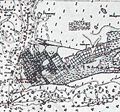 | Details | British Admiralty Hydrographical Office | 1920 |
| Antique Chart of Key West Harbor, Florida |
|
British Admiralty Hydrographical Office |
|
| 1920 |
| LOC:0 |
| $0.00 | British-Admiralty-Hydrographical-Office | Antique-Chart-of-Key-West-Harbor--Florida | SOLD
<br></br>
Fine engraved British Admiralty navigation chart of the Key West Florida area, from 1920. With Hawk Channel, Key West Harbor, Man of War Harbor, Rock Cay Channel, the Florida Strait and much more extending to the west past Boca Grande Cay, and Man Cay. Edition of February 1916 with last corrections in September 1920. A large, scarce chart of Key West before the Overseas Highway and the Florida land boom of the 1920's changed the face of the Sunshine State.
<br></br>
Shows the Overseas Railroad ("Flagler's Folly") which operated from 1912 to 1935.
<br></br>
Inset charts of North West Channel Bar and Key West Harbor. Inset table of tidal information for Sand Key Bar, Fort Taylor, and the Northwest Channel Bar.
<br></br>
First published at the Admiralty, 19 August 1907 under the superintendence of Rear Admiral A. Mostyn Field, F.R.S. Hydrographer. Sold by J.D. Potter. Engraved by Davies & Company. Chart number 2881. |
| 4770 |  | Details | British Admiralty Hydrographical Office | 1920 |
| Large Antique Chart of The Florida Keys |
|
British Admiralty Hydrographical Office |
|
| 1920 |
| LOC:61 |
| $1,375.00 | British-Admiralty-Hydrographical-Office | Large-Antique-Chart-of-The-Florida-Keys | Fine antique British Admiralty sea chart with cartographic coverage of the islands of the <b>Florida Keys</b>. Hydrographic data on this early 1866 British navigational chart extend past Key West. Though updated to 1920, this scarce survivor retains the appearance of a 19th-century British copperplate-engraved nautical chart, a visual charm more recent charts do not generally possess.
<br></br>
An inset diagram shows an example <b>navigational beacon</b>, made of iron, 36 feet in height and carrying an identifying letter within a moveable vane. These beacons, or day marks, delineated the southern boundary of the Florida Keys. The accompanying note states:
<br></br>
<div class="indenttextblock">
<img src="/PageImages/Beacon for 4770.jpg" alt="Florida keys navigational beacons (day marks)" width="120" align="left" style="margin: 0px 20px">
"The Beacons marking the outer Florida Reefs are distinguished by Letter or Numbers in the vane which each carries, commencing off Key West and proceeding in alphabetical or numerical order toward Cape Florida. With the exceptions of that American Shoal which is brown and that on Fowey Rock which is black, the Beacons are all painted white. These beacons are likely to be washed away."
</div>
<br></br>Manuscript notations in pencil from a previous owner record eight of the beacons as "damaged."
<br></br>
This chart of Lower Matacumbe Cay to Boca Grande Cay should be treasured by anyone with interests in fishing, sailing, or boating in the Florida Keys.
<br></br>
After U.S. Coast Survey charts from the last half of the 19th century. First published by the British Admiralty on July 18, 1866, with several editions and later corrections after, the last correction in 1920. Originally sold by J.D. Potter, agents, London. Chart no. 1098. |
| 1129 |  | Details | British Admiralty Hydrographical Office | 1924 |
| West Coast of Spain and Portugal |
|
British Admiralty Hydrographical Office |
|
| 1924 |
| LOC:0 |
| $0.00 | British-Admiralty-Hydrographical-Office | West-Coast-of-Spain-and-Portugal | <br></br>
SOLD
<br></br>
<br></br>
A fine folding British sea chart of the Atlantic coastline of Spain and Portugal from a chart originally published at the Admiralty in 1873, but this a later edition corrected to 1924.
<br></br>
This handsome chart provides numerous depth soundings, lighthouse locations, coastal details, and other hydrographic information from the Algarve coastline near Lagos, Portugal working northward past Lisbon and Oporto and ending near Cape Finisterre in Spain.
Six inset port plans including:
<div class="indenttextblock">
<ul style="list-style-type: circle;">
<li>Port Leixoes</li>
<li>Sines Bay</li>
<li>Cezimbra Bay</li>
<li>Peninsula of Peniche</li>
<li>Port Figueria</li>
<li>River Douro</li>
</ul>
</div>
Dissected and laid to fine linen. Early 20th century edition with last correction in 1924. Sellers label on the verso for Sifton, Praed, & Co. Ltd. The Map House. 67 St. James Street, London S.W. Owners ink stamp on cover "H.F. Cronin." Marbled board covers. |
| 1350 | 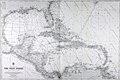 | Details | British Admiralty Hydrographical Office | 1925 |
| Old Authentic Admiralty Nautical Chart of the West Indies or Caribbean |
|
British Admiralty Hydrographical Office |
|
| 1925 |
| LOC:0 |
| $0.00 | British-Admiralty-Hydrographical-Office | Old-Authentic-Admiralty-Nautical-Chart-of-the-West-Indies-or-Caribbean | SOLD
<br></br>
Authentic British Admiralty nautical chart of the West Indies including Florida and the Gulf Coast. 1925.
<br></br>
Fine British Admiralty chart engraved and published from London first in 1903, this example with corrections to 1925. This bold, dark, engraved print retains the cartographic look and style of the late 19th century. More recent charts do not display the character of this beauty. Oval logo of the British Hydrographical office at lower left. Sold by J.D. Potter. Chart number 3273. |
| 4937 | 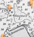 | Details | British Admiralty Hydrographical Office | 1925 |
| Awesome Chart of Vancouver Island Washington Territory |
|
British Admiralty Hydrographical Office |
|
| 1925 |
| LOC:65 |
| $875.00 | British-Admiralty-Hydrographical-Office | Awesome-Chart-of-Vancouver-Island-Washington-Territory | Very fine British Admiralty chart of Vancouver Island, the Strait of Juan de Fuca, San Juan Islands, the Washington Territory, Bellingham. An early 20th century copper-engraved chart with very fine detail. The topography and presentation are based on an earlier edition from the mid-19th century, with corrections as noted. With six fine inset elevation views of the coast.
<br/><br/>
"North America … West Coast … VANCOUVER ISLAND and Adjacent Shores of British Columbia Surveyed by Captain G.H. Richards, R.N." … First published by the Admiralty on Sept 25, 1865. Large corrections in 1890 and 1900 with last correction in 1925. Chart # 1917.
<br/><br/>
'Sir George Henry Richards (1820 –1896) was hydrographer to the British Admiralty from 1864 to 1874.
After joining the Royal Navy in 1832, Richards was a hydrographer on the coast of British Columbia in 1857–1862 and was the second British commissioner to the San Juan Islands Boundary Commission. Richards is responsible for the selection and designation of dozens of placenames along the British Columbia coast.
<br/><br/>
Richards conducted surveys in the Pacific Northwest aboard the survey ships Plumper, and later the Hecate. As second commissioner for the maritime boundary, he was tasked with a detailed survey of the waters between Vancouver Island and the American mainland, to help determine the location of the international boundary through the San Juan Islands. The survey was completed in June 1858.' (Dictionary of Canadian Biography. http://www.biographi.ca/en/bio.php?id_nbr=6394). |
| 5150 | 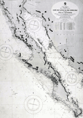 | Details | British Admiralty Hydrographical Office | 1925 |
| Antique Chart of Baja California and Sea of Cortez |
|
British Admiralty Hydrographical Office |
|
| 1925 |
| LOC:63 |
| $0.00 | British-Admiralty-Hydrographical-Office | Antique-Chart-of-Baja-California-and-Sea-of-Cortez | SOLD<br><br>This authentic British nautical chart includes the states of Baja California, Baja California Sur, Sonora, Mexico and the Sea of Cortez. This large chart will make a very attractive, unusual, and affordable gift for anyone with an interest in fishing or boating in the vicinity of Baja California. Numerous well-known fishing spots are noted including: San Jaime Bank, Golden Gate Bank, Outer Gorda Bank, Finger Bank, and Morgan Bank. Two inset profiles of Cabo San Lucas. Engraved by Davies and Company.
<br></br>
This is a later edition of a British Admiralty chart first engraved and published from London in 1879, and updated numerous times after that. Last corrections from 1925.
<br></br>
Coverage includes the entire Baja Peninsula and Gulf of California (Sea of Cortez) from San Diego, California to Cabo San Lucas, Mexico. Contains detailed names of the numerous rivers, lights, capes, and bays surrounding the Baja Peninsula. For example: Todos Santos Bay, Rosario Bay, Boca de Santo Domingo, Port San Bartolome, Cape San Lazaro, Santa Margarita Island, Lusitania Bank, Magdalena Bay, Pescadero Point, San Jose del Cabo Bay, Ceralbo Island, and San Jose Island.
<br></br>
This bold dark lithographed chart retains the cartographic look and style of the late 19th century. Logo of the British Hydrographical Office at top of the title block. Published from London on April 9, 1879 (1925). Number 2324 |
| 1133 |  | Details | British Admiralty Hydrographical Office | 1925 |
| Old nautical chart of the west Mediterranean Sea |
|
British Admiralty Hydrographical Office |
|
| 1925 |
| LOC:0 |
| $0.00 | British-Admiralty-Hydrographical-Office | Old-nautical-chart-of-the-west-Mediterranean-Sea | SOLD
<br></br>
A fine folding British sea chart of the western Mediterranean sea. Based on a chart originally published at the Admiralty in 1878 under the superintendence of Captain F.J. Evans.
<br></br>
This handsome chart provides numerous depth soundings, lighthouse locations, coastal details, and other hydrographic information for the Mediterranean coastline of Spain, Morocco, and Algeria including the important Strait of Gibraltar.
<br></br>
Eighteen inset port and anchorage plans including:
<div class="indenttextblock">
<ul style="list-style-type: circle;">
<li>Salobrena Anchorage</li>
<li>Cala Honda</li>
<li>Ferro Castle Anchorage</li>
<li>Adra Anchorage</li>
<li>Almeria Road</li>
<li>Cape de Gata</li>
<li>Port Genoves and San Jose Bay</li>
<li>San Pedro Bay</li>
<li>Carboneras Bay</li>
<li>Port Aguilas</li>
<li>Cope Anchorage</li>
<li>Mazarron and Surida Bays</li>
<li>Porman Bay</li>
<li>Escuellos Bay</li>
<li>Nerja Anchorage</li>
<li>Herradura Bay</li>
<li>Berenguelas Bay</li>
<li>Alboran Island</li>
</ul>
</div>
Dissected and laid to fine linen. Early 20th century edition with numerous corrections, the last in correction in 1925. Sellers label on the verso for Sifton, Praed, & Co. Ltd. The Map House. 67 St. James Street, London S.W. Owners ink stamp on cover "H.F. Cronin." Marbled board covers. Number 2717. |
| 1076 | 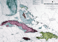 | Details | British Admiralty Hydrographical Office | 1926 |
| Antique British Chart of the Caribbean Sea and West Indies |
|
British Admiralty Hydrographical Office |
|
| 1926 |
| LOC:61 |
| $750.00 | British-Admiralty-Hydrographical-Office | Antique-British-Chart-of-the-Caribbean-Sea-and-West-Indies | Spectacular large and original early twentieth-century nautical chart of south Florida and the Caribbean. Points in the USA include towns south of Orlando: Tampa, Cape Canaveral, Key West , Lake O-kee-cho-bee, and much more. Includes the islands of Jamaica, Cuba, Hispaniola, the Bahamas, Turks and Caicos. Hundreds of soundings and navigational hazards are identified.
<br></br>
Later edition of a British Admiralty chart first engraved and published from London in 1876. This bold, dark print retains the cartographic look and style of the late 19th century with updated hand-coloring by a professional map colorist. More recent charts do not display the character of this beauty.
<br></br>
Oval logo of the British Hydrographical office at upper right. Price when sold was three shillings. Chart number 761. Sold by J.D. Potter. |
| 1338 | 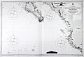 | Details | British Admiralty Hydrographical Office | 1926 |
| Chart of Lower Baja California, Cabo San Lucas, to Manzanilla Bay |
|
British Admiralty Hydrographical Office |
|
| 1926 |
| LOC:0 |
| $525.00 | British-Admiralty-Hydrographical-Office | Chart-of-Lower-Baja-California--Cabo-San-Lucas--to-Manzanilla-Bay | Amazing, clean, authentic British nautical chart of lower Baja Peninsula and west coastal Mexico with Sinaloa, Jalisco and the Sea of Cortez. Heading southward this popular and highly attractive chart covers from San Ignaciao Bay to Manzanillo Bay. This large chart will make a very attractive, unusual, and affordable gift for anyone with an interest in fishing or boating in the vicinity of Baja California. Thousands of depth soundings and numerous well-known fishing spots are noted including: San Jaime Bank, Golden Gate Bank, Outer Gorda Bank, Finger Bank, and Morgan Bank. Two inset profile views at top of the Baja Californa coast as seen from offshore near Las Animas.
<br></br>
Later edition of a British Admiralty chart first engraved and published from London in 1879; this edition to 1916 and the last corrections made in 1926. Coverage includes the lower Baja California Peninsula and Gulf of California (Sea of Cortez) from Las Animas to Cabo San Lucas, Mexico, Mazatlan, Cape Corrientes, and on to Manzanillo Bay. Contains detailed names of the numerous rivers, lights, capes, and bays surrounding the Baja Peninsula. Includes the Revillagigedo Archipelago.
<br></br>
Bold dark lithographed print retains the cartographic look and style of the late 19th century. More recent charts do not display the character of this beauty. Logo of the British Hydrographical Office at top of the title block. Originally published from London on April 9, 1879 but the edition of 1916 with corrections to 1926. Number 2323. |
| 6808 |  | Details | British Admiralty Hydrographical Office | 1926 |
| Scarce Antique Chart Malacca Strait Cape Rachado to Singapore |
|
British Admiralty Hydrographical Office |
|
| 1926 |
| LOC: |
| $1,400.00 | British-Admiralty-Hydrographical-Office | Scarce-Antique-Chart-Malacca-Strait-Cape-Rachado-to-Singapore | Original British Admiralty chart of the Strait of Malacca from Cape Rachado to Singapore, first published in 1896 under the superintendence of Admiral Wharton, Hydrographer. The coast of the Malay Peninsula and soundings taken from British Surveys in 1852-5; H.M. surveying ship Egeria (1893); and H.M. surveying ship Waterwitch 1909. Last corrected in 1926. Includes Singapore with numerous soundings.
<br><br>
Inset chart of "Approaches to Malacca" at upper right.
<br><br>
Sold by J.D. Potter agent for the Admiralty. Price when issued was four shillings. Admiralty chart number 795. Engraved by Davies and Company.
<br><br>
The first European chart of the Strait of Malacca was likely produced by Portuguese explorers in the early 16th century. After capturing Malacca in 1511, the Portuguese established a strong presence in the region and began extensive maritime exploration and cartography. |
| 1075 | 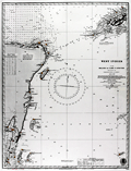 | Details | British Admiralty Hydrographical Office | 1927 |
| Chart of the eastern Yucatan Peninsula with Cozumel and Tulum |
|
British Admiralty Hydrographical Office |
|
| 1927 |
| LOC:0 |
| $0.00 | British-Admiralty-Hydrographical-Office | Chart-of-the-eastern-Yucatan-Peninsula-with-Cozumel-and-Tulum | SOLD<br></br>Very cool antique British chart of the east side of Mexico's Yucatan Peninsula with the Yucatan Channel and the west end of Cuba. Produced decades before the building boom of the 1970s and beyond. Several areas offshore carry the printed note: "Good Fishing" . Key features include: Cozumel Island, Tulum, Isla Blancilla, Yalahau Fort, Cabo Catoche, Puerto de Mujeres, Bahia de la Ascension, Arrowsmith Bank, Bahia del Espititu Santo, Banco Chinchorro, Turneffe, Lighthouse Reef, and Swan Island.
<br></br>
Lighthouses and aids to navigation are highlighed in orange. Steel engraved nautical chart with the oval logo of the "Hydrographic Office" at bottom right.
<br></br>
Frequent updates noted at bottom left. Large corrections to 1915. Small corrections to 1925 with an additional hand written correction to 1927. Sold by J. D. Potter, Agent for the Sale of the Admiralty Charts. Chart number 1204. Price when issued was two shillings. |
| 5077 |  | Details | British Admiralty Hydrographical Office | 1927 |
| Chart of Harbours and Anchorages in the Hawaiian or Sandwich Islands 1927 |
|
British Admiralty Hydrographical Office |
|
| 1927 |
| LOC:59 |
| $1,350.00 | British-Admiralty-Hydrographical-Office | Chart-of-Harbours-and-Anchorages-in-the-Hawaiian-or-Sandwich-Islands-1927 | Bold, engraved chart with harbor plans in the Hawaiian Islands first published by the British Admiralty in 1891 but 1927. Retains the distinctive appearance of antique British nautical charts. "Harbours and Anchorages in the Hawaiian or Sandwich Islands from Surveys of the Hawaiian Government". Engraved by Edward Weller. Excellent topographic detail for mountains and hills.
<br></br>
Apparently, quite scarce. No record of a sale in AMPR and only one copy in WorldCat.
<br></br>
Published at the Admiralty, London, February 5, 1891 under the superintendence of Captain W. J. L. Wharton, Hydrographer. This edition: 1912. Last correction in 1927. Sold by J.D. Potter.
<br></br>
Includes large-scale harbor and anchorage plans for 12 locations in Hawaii:
<div class="indenttextblocksingle">
<ul style="list-style-type: circle;">
<li>Waimea Bay, Kauai</li>
<li>Hanamaula Bay, Kauai</li>
<li>Kapueokahi Bay, Maui</li>
<li>Kaanapali Anchorage, Maui</li>
<li>Lahaina Roads, Maui</li>
<li>Pukoo Harbor, Molokai</li>
<li>Kaunakakai Harbor, Molokai</li>
<li>Kamalo Harbor, Molokai</li>
<li>Waimea Bay, Oahu</li>
<li>Waianae, Oahu</li>
<li>Waialua Bay, Oahu</li>
<li>Kawaihae Bay, Hawaii</li>
<li>Mahukona Harbor, Hawaii</li>
</ul>
</div> |
| 5081 | 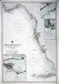 | Details | British Admiralty Hydrographical Office | 1929 |
| Antique chart of Florida Tortugas Cays to Cap San Blas |
|
British Admiralty Hydrographical Office |
|
| 1929 |
| LOC:61 |
| $0.00 | British-Admiralty-Hydrographical-Office | Antique-chart-of-Florida-Tortugas-Cays-to-Cap-San-Blas | SOLD<br><br>
Bold original British Admiralty nautical chart 1890 (1928) of the southwest coast of Florida along the Gulf of Mexico: "Tortugas Cays to Cape San Blas from the latest United States Coast Surveys". Includes extensive coastal detail with St. Andrews Sound, Cape San Blas, Apalachicola, Sea Horse Reef, Anclote Key, Tampa Bay, Punta Gorda, Cape Romano, Cape Sable, Key West, and the Tortuga Bank.
<br></br>
Published at the Admiralty, London on January 24, 1890 under the superintendence of Captain W. J. L. Wharton, Hydrographer. This is the edition of 1915 with last correction in 1929. Chart number 1274. Engraved by Davies and Company.
<br></br>
Includes three large inset charts of Florida ports and Harbors:
<div class="indenttextblocksingle">
<ul style="list-style-type: circle;">
<li>Apalachicola Bay: West Pass. 1911.</li>
<li>St. Marks River. 1909.</li>
<li>St. George Sound: East Pass. 1914.</li>
</ul>
</div> |
| 1345 | 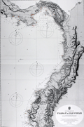 | Details | British Admiralty Hydrographical Office | 1929 |
| Antique Nautical Chart of Costa Rica, Panama, Colombia and Equador |
|
British Admiralty Hydrographical Office |
|
| 1929 |
| LOC:0 |
| $225.00 | British-Admiralty-Hydrographical-Office | Antique-Nautical-Chart-of-Costa-Rica--Panama--Colombia-and-Equador | Large, graphically striking, antique engraved British Admiralty sea chart of the Pacific coast extending from the Gulf of Dulce, Costa Rica, through all of Panama, and down the west coast of Colombia and Equador. The beauty of this chart lies in the extensive and bold engraving of mountain ranges and other topographical details.
<br></br>
Numerous lighthouses are picked out with red or yellow highlights. Last corrections made in manuscript with red ink.
<br></br>
First published by the Admiralty from London in August 1903 under the superintendence of Royal Navy Hydorgrapher Rear Admiral Wharton. This very attractive edition of the scarce Admiralty chart was printed with last corrections to 1929.
<br></br>
Sold by J.D. Potter Agent for The Admiralty. |
| 5078 | 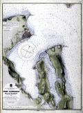 | Details | British Admiralty Hydrographical Office | 1929 |
| Fine harbor chart of Port Townsend, Washington and Kilisut Harbor |
|
British Admiralty Hydrographical Office |
|
| 1929 |
| LOC:68 |
| $790.00 | British-Admiralty-Hydrographical-Office | Fine-harbor-chart-of-Port-Townsend--Washington-and-Kilisut-Harbor | Bold original harbor chart of Port Townsend / Kilisut Harbor, Washington drawn and published from London in June, 1893 by the British Admiralty under the superintendence of Captain W. J. L. Wharton, Hydrographer. Chart data are after the U.S. Coast Survey chart of 1892 (1929). Scarce.
<br></br>
The chart is a key historical record of Port Townsend’s late-19th-century ambitions, capturing the town at the height of its expectation to become the dominant Pacific Northwest port. The detailed street grid, wharves, anchorages, and shoreline infrastructure are set against meticulously rendered bathymetry and shoreline topography, revealing how urban development was constrained and shaped by navigational realities during the steamship era.<br><br>
Fine topographic contour lines and details on this old nautical chart. Points of interest include Port Hadlock, Irondale, Chimikim Creek, Mystery Bay, Oak Bay, Marrowstone Island, and Fort Townsend.
<br></br>
Sold by J.D. Potter. Chart number 1792. Engraved by Edward Weller. Scale: 1 / 24,361. Last correction 1929. |
| 5204 | 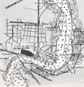 | Details | British Admiralty Hydrographical Office | 1930 |
| Nautical chart of St. Andrew Sound to St. John River, Florida |
|
British Admiralty Hydrographical Office |
|
| 1930 |
| LOC:61 |
| $0.00 | British-Admiralty-Hydrographical-Office | Nautical-chart-of-St--Andrew-Sound-to-St--John-River--Florida | SOLD
<br><br>
This scarce original British Admiralty sea chart of the Florida east coast retains the look and feel of a fine late 19th-century chart. Chart coverage stretches southward from St. Andrew Sound, near Jekyll Island and Cumberland Island Georgia, to the St. John River, near Jacksonville, Florida. Includes the Cumberland Sound, St. Mary River, Amelia Island, Nassau River, and Jacksonville.
<br></br>
This fine nautical chart of the Florida coast was published at the Admiralty April 22, 1879 under the superintendence of Captain F.J. Evans. Sold by J.D. Potter. Engraved by Edward Weller. Chart number 853. Edition of 1916. Last minor correction in 1930. |
| 899 | 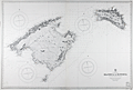 | Details | British Admiralty Hydrographical Office | 1930 |
| Balearic Islands of Majorca and Minorca |
|
British Admiralty Hydrographical Office |
|
| 1930 |
| LOC:0 |
| $0.00 | British-Admiralty-Hydrographical-Office | Balearic-Islands-of-Majorca-and-Minorca | SOLD<br></br>
Bold, authentic British sea chart of two of Spain's Balearic Islands: Majorca (Mallorca) and Minorca (Menorca). In excellent condition. Originally engraved and published in 1897 from London by the Admiralty under the superintendence of Rear Admiral W.J.L. Wharton. Lighthouses and other navigational aids are hand colored in yellow. This large chart will make a very attractive, unusual, and affordable gift for anyone with an interest in fishing or boating in the vicinity of Mallorca or Menorca in the Mediterranean Sea. Thousands of depth soundings, numerous bays, headlands, and villages pack this old pre-war nautical chart. Key habitations include Palma, Pollensa, Arta, Manacor, and Santany, Mallorca.
<br></br>
This version of the Balearic Island chart dates to 1930 when it was published with corrections. This bold dark lithographed print retains the sharp cartographic look and style of the late 19th century. More recent charts do not display the character of this beauty. Logo of the British Hydrographical Office at top of the title block. Number 1317. Sold by J. D. Potter, 145 Minories. |
| 6801 | 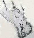 | Details | British Admiralty Hydrographical Office | 1933 |
| Original Nautical Chart Baja Cabo San Lucas |
|
British Admiralty Hydrographical Office |
|
| 1933 |
| LOC: |
| $0.00 | British-Admiralty-Hydrographical-Office | Original-Nautical-Chart-Baja-Cabo-San-Lucas | SOLD
<br><br>
Fine British Admiralty nautical chart of lower or Baja California published by the Admiralty on July 25, 1903 (last correction in 1933). Shows the Baja California Peninsula south of Ameljas Bay (24 degrees 38 minutes N latitude). The southernmost 15 miles of the Baja Peninsula with Cape Falso, San Lucas Bay, and Cabo San Lucas are shown in an inset or "compartment" at bottom right. Chart number 3327.
<br><br>
Numerous soundings in fathoms. Fine topographic detail for the coastal interior of the peninsula. |
| 5067 |  | Details | British Admiralty Hydrographical Office | 1941 |
| Large chart of eastern Singapore Strait |
|
British Admiralty Hydrographical Office |
|
| 1941 |
| LOC:59 |
| $950.00 | British-Admiralty-Hydrographical-Office | Large-chart-of-eastern-Singapore-Strait | Large, used nautical chart for the eastern portion of Singapore Strait with eastern Singapore Island. Last corrections in 1941 were made shortly before the invasion of Singapore by Japan in February 1942.
Manuscript ink lines with notation: "Keep south of this line."
<br></br>
Published at the Admiralty October 1, 1927 under the superintendence of Rear Admiral H.P. Douglas, Hydrographer. Chart number 3834. Engraved 1927. Verso is blank with file drawer label. |
| 4879 |  | Details | British Admiralty Hydrographical Office | 1944 |
| Plans on the North East Coast of Bahrein Island |
|
British Admiralty Hydrographical Office |
|
| 1944 |
| LOC:54 |
| $0.00 | British-Admiralty-Hydrographical-Office | Plans-on-the-North-East-Coast-of-Bahrein-Island | SOLD
<br></br>
Very scarce nautical charts of Bahrain (Bahrein) Harbor, Khor Kaliya, and Manama. 1936 / 1944. Charts are based on surveys by the British Admiralty's surveying ship "Ormonde" in 1932. Shows Bahrain's major population center, port and harbors before most of the massive construction that now fills the area.
<br></br>
No other example of this map is found online and only one sale of the 1905 edition in 2008.
<br></br>
Three charts / plans on one page:
<div class="indenttextblocksingle">
<ul style="list-style-type: circle;">
<li>Approaches to Bahrein Harbor and Khor Kaliya</li>
<li>Bahrein Harbour</li>
<li>Khor Kaliya</li>
</ul>
</div>
Last correction 1944. Chart # 3792. Published at the Admiralty 14th Aug. 1936 under the
Superintendence of Rear Admiral J.A. Edgell. |
| 3678 |  | Details | British Admiralty Hydrographical Office | 1953 |
| Chart of Channel Islands and Coast of France |
|
British Admiralty Hydrographical Office |
|
| 1953 |
| LOC:0 |
| $180.00 | British-Admiralty-Hydrographical-Office | Chart-of-Channel-Islands-and-Coast-of-France | An authentic 20th-century British nautical chart of the Channel Islands and the nearby Normandy coast of France . This large chart includes the islands of Jersey, Guernsey, Alderney, Sark and some smaller islands. Last corrections are dated to 1953.
<br></br>
Logo of the British Hydrographical Office at top of the title block. Number 2669. |
| 4880 | 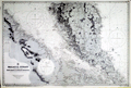 | Details | British Admiralty Hydrographical Office | 1956 |
| Original Chart Malay Peninsula Malaysia and Singapore |
|
British Admiralty Hydrographical Office |
|
| 1956 |
| LOC:59 |
| $0.00 | British-Admiralty-Hydrographical-Office | Original-Chart-Malay-Peninsula-Malaysia-and-Singapore | SOLD <br><br>
British Admiralty (United Kingdom Hydrographic Office) chart of the Strait of Malacca with portions of coastal Sumatra and Malaysia (corrected state). Published May 21, 1954 but this sheet with corrections to 1956. This chart is on a slightly larger scale (1 / 500,000) than chart 1388 'Pandang and One Fathom Bank to Singapore' (1 / 885,000).
<br></br>
<b>Singapore</b> at bottom right. Covers portions of the east coast of Malaysia as well as the west coast. Fine topographic detail of the interior of Malaysia.
<br></br>
Engraved in 1898 and published on June 30, 1898 by the Admiralty. Last corrections in 1956. Chart # 1355. |
| 4868 | 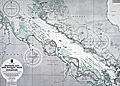 | Details | British Admiralty Hydrographical Office | 1957 |
| Chart Malacca Strait Pandang One Fathom Bank to Singapore. |
|
British Admiralty Hydrographical Office |
|
| 1957 |
| LOC:59 |
| $500.00 | British-Admiralty-Hydrographical-Office | Chart-Malacca-Strait-Pandang-One-Fathom-Bank-to-Singapore- | British Admiralty (United Kingdom Hydrographic Office) chart of the Strait of Malacca with portions of coastal Sumatra and Malaysia. Published May 21, 1954 but this sheet with corrections to 1957. Verso with a green ink stamp and the 1957 correction date by the seller: Iver C. Weilbach and Co. Copenhagen.
<br></br>
Singapore at bottom right. This presumed second state of the 1954 edition of 'Pandang and One Fathom Bank to Singapore' is distinguished by an expertly executed 2" x 3" pasted correction to coastal details at 103 degrees longitude in the vicinity of Senggarang. Includes the Johore Strait.
<br></br>
Scale 1/885,000. Chart number 1358. |
| 5028 | 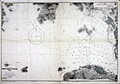 | Details | British Admiralty Hydrographical Office | 1963 |
| Chart of Hong Kong Waters West China South Coast |
|
British Admiralty Hydrographical Office |
|
| 1963 |
| LOC:59 |
| $1,000.00 | British-Admiralty-Hydrographical-Office | Chart-of-Hong-Kong-Waters-West-China-South-Coast | Twentieth-century British Admiralty nautical chart of western Hong Kong Harbor, Hong Kong Island, Victoria Harbor, and Belcher Harbor. Extends as far west as Lantau Island in the vicinity of Hong Kong Disneyland.
<br></br>
Engraved and first published by the Admiralty in 1903, this edition contains minor corrections to 1963. Chart number 3280. Numerous updates to aids to navigation shown in red ink. |
| 3606 | 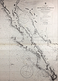 | Details | British Admiralty Hydrographical Office | 1965 |
| Chart of Baja California and Sea of Cortez |
|
British Admiralty Hydrographical Office |
|
| 1965 |
| LOC:0 |
| $0.00 | British-Admiralty-Hydrographical-Office | Chart-of-Baja-California-and-Sea-of-Cortez | SOLD
<br></br>
Later 1965 edition of a British Admiralty chart first engraved and published from London in 1879, and updated numerous times after that. Coverage includes the entire Baja Peninsula and Gulf of California (Sea of Cortez) from San Diego, California to Cabo San Lucas, Mexico.
<br></br>
Bold dark lithographed print retains the cartographic look and style of the late 19th century. Logo of the British Hydrographical Office at top of the title block. Published from London on April 9, 1879, but 1965. Number 2324 |
| 781 | 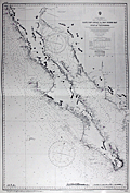 | Details | British Admiralty Hydrographical Office | 1971 |
| Chart of Baja California and the Sea of Cortez |
|
British Admiralty Hydrographical Office |
|
| 1971 |
| LOC:0 |
| $0.00 | British-Admiralty-Hydrographical-Office | Chart-of-Baja-California-and-the-Sea-of-Cortez | SOLD but… we have been able to acquire
<a href="https://www.rarecharts.com/ShowDetail/Creator/British-Admiralty-Hydrographical-Office/Title/Antique-Chart-of-Baja-California-and-Sea-of-Cortez/5150" target="_blank"> an earlier edition of the same chart from 1925 now in stock.
</a>
<br></br>
<hr>
<br></br>
British Admiralty chart first engraved and published from London in 1879, and updated numerous times after that. Coverage includes the entire Baja Peninsula and Gulf of California (Sea of Cortez) from San Diego, California to Cabo San Lucas, Mexico. |
| 697 |  | Details | British Admiralty Hydrographical Office | 1972 |
| Acapulco Harbor |
|
British Admiralty Hydrographical Office |
|
| 1972 |
| LOC:0 |
| $125.00 | British-Admiralty-Hydrographical-Office | Acapulco-Harbor | Neat, attractive, authentic 20th century nautical chart of Acapulco, Mexico by the British Admiralty after an 1881 U.S. chart. This chart has character. Though published by the Admiralty in 1972, this chart retains much of the style and appearance of earlier copper-plate engraved charts but on modern paper in fine condition. Features shown on the map include Fort San Diego, Isla Roqueta or Isla Grifo, Puerto Marques, Punta Rodrigo, Punta Diamante (Diamond Point), Punta Bruja, Bahia St. Lucia, Punta Lorenz, Farallon de Obispo, the Fiscal Wharf and las Dos Piedras. The town of Acapulco is shown as it must have looked when the chart was first published… very small in extent.
<br></br>
This chart was originally published in August 1849 but updated and corrected numerous times, as documented at bottom left of the chart,- including 1882 (re-engraved) and 1945, and this copy dates to 1972. Numerous soundings and aids to navigation are noted.
<br></br>
With two profile view insets: 1) "Acapulco from the Westward, Isla Roqueta, 093° distant 9 or 10 miles" Boca Chica and Puerto Marques and 2) "Acapulco from the S.W., I Roqueta 042° distant 9 or 10 miles" with Punta Diamante. Modern compass rose with half fleur-de-lis indicating North.
Verso is stamped "Printed [19]72 1944 Acapulco Harbor. Folio 25. Consecutive number 11." Chart no. 1944. |
| 5079 |  | Details | British Admiralty Hydrographical Office | 1973 |
| Plans in the Islas Baleares from Spanish Government Charts |
|
British Admiralty Hydrographical Office |
|
| 1973 |
| LOC:58 |
| $175.00 | British-Admiralty-Hydrographical-Office | Plans-in-the-Islas-Baleares-from-Spanish-Government-Charts | Plans of the islands Ibiza and Formentera in Spain's Mediterranean Balearic Islands. Engraved in 1902 and published from London in July 8, 1902 by the British Admiralty under the superintendence of Captain W. J. L. Wharton, Hydrographer. Charts are after the Spanish Government Charts, 1898 - 1900. This sheet with corrections to 1973.
<br></br>
Includes the Balearic Islands of Ibiza and Formentera at a scale of 1 / 195,000 and the channel between Ibiza and Espalmador at a scale of 1 / 36,420
<br></br>
Chart number 3276. Crown Copyright Reserved. |
| 6803 |  | Details | British Admiralty Hydrographical Office | 1974 |
| Original Admiralty Nautical Chart of Providence Island, Bahamas |
|
British Admiralty Hydrographical Office |
|
| 1974 |
| LOC: |
| $255.00 | British-Admiralty-Hydrographical-Office | Original-Admiralty-Nautical-Chart-of-Providence-Island--Bahamas | A fine British Admiralty nautical chart of the Bahamas Island of New Providence, first published in August, 1843. Retains the look of a mid-19th century copper-engraved sea chart. Admiralty chart # 1489.
<br><br>
At top of chart is a coastal elevation view of the Town of Nassau, on the Island of New Providence, from a distance offshore.
<br><br>
This item is the sixth edition of 1914 with corrections to 1974. |
| 702 | 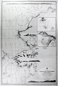 | Details | British Admiralty Hydrographical Office | 1977 |
| Yukon River to Point Barrow Alaska |
|
British Admiralty Hydrographical Office |
|
| 1977 |
| LOC:65 |
| $175.00 | British-Admiralty-Hydrographical-Office | Yukon-River-to-Point-Barrow-Alaska | Very decorative 20th century British nautical chart of the Alaskan West Coast that expresses much of the fine character of the older copper-plate engraved navigation charts. Detailed soundings in the Bering Sea from Alaska westward 51 miles to Asia with Cape Dezhnev ( Dezhneva ) in Russia. This large attractive specimen is graced with four splendid inset profile views that show the rugged, snow-capped terrain of the Alaskan coast: At top- a broad view stretching from Cape Thompson to Cape Seppings and Mulgrave Hills fills the width of the chart; lower are profile views of Cape Prince of Wales and Cape York; the Diomede Islands; and Cape Lisburne.
<br></br>
Key features include Kotzebue and Nome, Alaska, the Chuckchi Sea, Bering Sea, Diomede Islands, St. Lawrence Island, mouths of the Yukon River, Norton Bay, Cape Nome, and Cape Prince of Wales. Numerous soundings, navigation hazards, and aids to navigation are noted. Originally published from London in 1907, the chart underwent numerous updates and corrections over the following 70 years as noted in several locations on the chart.
<br></br>
The chart is based on the exploration of the Pacific Coast and Alaska led by Frederick William Beechy aboard the refitted survey ship "Blossom" which had recently been converted from an 24 gun sloop-of-war. During the course of their three-year voyage Beechy's orders were to explore the Bering Strait and to attempt to rendezvous with Parry and Franklin aboard HMS Fury and Hecla, who were searching for a Northwest Passage from the East coast. Beechy is credited with the discovery of Port Clarence, one of the featured insets in this chart.<br></br>
With inset detailed plans: <ul>
<li>"Plan of the Anchorage of Chamisso in Kotzebue Sound"</li>
<li> "Plan of Port Clarence and Grantley Harbor" </li>
<li> the cut between Port Clarence and Grantley Harbor. </li>
</ul>
Number 563. Title cartouche contains the oval logo of the British Hydrographic Office. |
| 6552 |  | Details | British Admiralty Hydrographical Office | 1978 |
| Admiralty Chart Baja California Sea of Cortez with Cabo San Lucas |
|
British Admiralty Hydrographical Office |
|
| 1978 |
| LOC:0 |
| $500.00 | British-Admiralty-Hydrographical-Office | Admiralty-Chart-Baja-California-Sea-of-Cortez-with-Cabo-San-Lucas | Original later issue of a British Admiralty nautical chart first engraved and published in London at the Admiralty on April 9, 1879, under the superintendence of Royal Navy Hydrographer Captain F.J. Evans and updated with corrections. Last corrected in 1978.
<br></br>
Coverage on this fine Admiralty nautical chart includes the entire Baja Peninsula and Gulf of California (Sea of Cortez) from San Diego, California to Cabo San Lucas, Mexico.
<br></br>
Numerous well-known fishing spots are noted including: San Jaime Bank, Golden Gate Bank, Outer Gorda Bank, Finger Bank, and Morgan Bank. Two inset profiles of Cabo San Lucas.
<br></br>
Bold, dark, lithographed print retains the cartographic look and style of the late 19th century. Original engraving was executed by Davies and Company. Logo of the British Hydrographical Office at top of the title block. Chart Number 2324. Crown copyright reserved. |
| 3679 |  | Details | British Admiralty Hydrographical Office | 1986 |
| Chart of Eastern North America and Caribbean |
|
British Admiralty Hydrographical Office |
|
| 1986 |
| LOC:65 |
| $180.00 | British-Admiralty-Hydrographical-Office | Chart-of-Eastern-North-America-and-Caribbean | An authentic 20th-century British nautical chart of the east coasts of the U.S. and Canada. Includes Mexico, Central America, the Caribbean Islands, and northern South America.
<br></br>
Bold dark print retains the cartographic look and style of the late 19th century. Logo of the British Hydrographical Office at top of the title block. Published from London on April 9, 1870 (later edition). Last corrections from 1986. Number 2060b. |