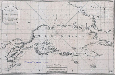
DESCRIPTION: Very scarce and wonderfully-engraved French sea chart of the Sea of Marmara, the Dardenelles, Istanbul (Constantinople), the Bosporus, and southern Black Sea from 1826. Depth soundings on this large antique navigational chart extend from the island of Tenedos in the Aegean Sea through the Dardenelles and the Sea of Marmara, up the Bosporus to Istanbul and then into the Black Sea (Mer Noire).
Dedicated to Christophe de Chabrol de Crouzol, Minister of the French Navy from 1824-1829. This supports our date of 1826 though the middle two characters in the date have been effaced leaving only (1--6).
With a large inset chart by Kauffer of the walled city of Constantinople, Turkey and the entire Bosporus and a second inset chart with the Hellespont and Dardenelles by le Comte de Truguet.
 No copy of this chart is found online, nor in the AMPR, while 11 sales are recorded of Bellin's earlier "Carte de la Mer de Marmara" at left. No copy of this chart is found online, nor in the AMPR, while 11 sales are recorded of Bellin's earlier "Carte de la Mer de Marmara" at left.
A brief biography in French explains that Etienne Collin, engraver of this work, was the nephew of the renowned Beautemps-Beaupre, considered to be the father of French hydrography. Beautemps-Beaupre practiced an "enlightened nepotism". The biography notes during Beaupre's tenure as Hydrographer "that the functions (geographers, hydrographers, engravers, Cimetiere, ....) within the Depot were largely occupied by members of the Buache-Beautemps-Collin family."
"Etienne Collin (1770, 1841) né à la Neuville-au-Pont. Cousin de Beautemps-Beaupré, il est recruté par le célèbre hydrographe qui pratique un certain népotisme éclairé" ... (Source: http://cartes-martinique.pagesperso-orange.fr/Graveurs_HydroFran.htm)
The Depot de la Marine was established in 1720 under the French Ministry of the Navy to collect, preserve, and publish nautical charts, sailing directions, and maritime intelligence for the French naval service. Its purpose was both archival and practical: to centralize geographic knowledge gathered from voyages, surveys, and colonial administration, and to convert that information into standardized charts for navigation. Over the eighteenth century the Depot became the principal hydrographic authority of France, issuing engraved sea charts that incorporated data from naval expeditions, colonial outposts, and scientific voyages.
Following the French Revolution, the institution was reorganized and its chart production expanded, particularly during the late eighteenth and early nineteenth centuries as global maritime competition intensified. The Depot de la Marine supervised official surveys, revised earlier charts, and maintained copperplates for continued reissue as coastal knowledge improved. In 1886 it was formally reorganized as the Service hydrographique de la Marine, the predecessor of today’s French hydrographic office. Charts bearing the Depot imprint remain important records of French naval activity, colonial expansion, and the technical development of European hydrography.
PUBLICATION DATE: 1826
GEOGRAPHIC AREA: Turkey
BODY OF WATER: Sea of Marmara
CONDITION: Very Good.
Well maintained. Slightly, evenly browned. No condition issues save one pinhole somewhere in nowhere. Ample margins. Solid. Date is effaced.
COLORING: None
ENGRAVER: E. Collin
SIZE: 37
" x
23 "
ITEM PHYSICAL LOCATION: 66
PRICE: $2500
ADD TO CART

|