| | Thumbnail | | Creator | Date | Title / Author / Date / Location | Price | | | Description |
| 869 | 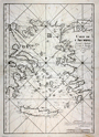 | Details | Depot de la Marine | 1745 |
| Antique Chart of the Aegean Sea, Turkey and Greek Archipelago |
|
Depot de la Marine |
|
| 1745 |
| LOC:58 |
| $1,400.00 | Depot-de-la-Marine | Antique-Chart-of-the-Aegean-Sea--Turkey-and-Greek-Archipelago | Scarce antique chart of the Greek Archipelago including parts of mainland Greece and Turkey. This large copperplate-engraved nautical chart of the Aegean Sea is based on surveys by French naval pilot Arnaud Grognard (1681-1751) and published by the Depot de la Marine.
<br></br>
Dedicated to Jean-Frédéric Phélypeaux comet de Maurepas (1701-1781). Interesting signed approval by Jacques Bellin, of the French Depot de la Marine" which translates roughly to: 'I examined the chart of the archipelago presented by Sieur Grognard, a pilote of the department from Toulon, under orders of the Count de Maurepas, and I find it is acceptable for navigation…". Bellin published many charts under his own name and it is unusual to find this type of signed attribution of a chart published by the Depot. |
| 683 | 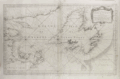 | Details | Depot de la Marine | 1754 |
| Gulf of St. Lawrence |
|
Depot de la Marine |
|
| 1754 |
| LOC:0 |
| $0.00 | Depot-de-la-Marine | Gulf-of-St--Lawrence | SOLD<br></br>
Large antique mid 18th century French nautical chart of the entire Gulf of St. Lawrence. Published by the French Depot des Cartes, Plans et Journaux de la Marine in 1754, this variant example of the chart does not contain an attribution to J.N. Bellin, uncovering Pinquin ( Penguin ) Island in the space previously occupied by the cartouche.
<br></br>
Includes the Island of Newfoundland ( Isle de Terre-Neuve ) with the town of St. John ( St. Jean ), Anticosti Island, the Grand Banks, and Isle Royale. Very interesting is the addition of several very small manuscript? annotations to the chart very near to the Islands of Miquelon and St. Pierre- the only two French possessions in the area. The annotations include the addition of a name to a very small island "Isle Verte" (Green Island) and the overwriting / obscuring of the name for one of the headlands- "le Chapeau Rouge'.
<br></br> |
| 1128 | 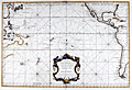 | Details | Depot de la Marine | 1756 |
| Antique French Sea Chart of the Pacific Ocean with Australia |
|
Depot de la Marine |
|
| 1756 |
| LOC:62 |
| $2,200.00 | Depot-de-la-Marine | Antique-French-Sea-Chart-of-the-Pacific-Ocean-with-Australia | Antique sea chart of the Pacific Ocean with a very decorative rococo cartouche. This old French nautical chart contains incomplete representations of Australia and New Zealand coastal regions, reflecting the lack of knowledge that still existed at that time. 2nd. Ed. By J.N. Bellin. A later edition of this chart includes the Depot de la Marine engraved stamp at bottom left.
<br></br>
Coverage spans the Pacific from east Asia to the east coast of the United States. The chart will display beautifully when framed. |
| 753 | 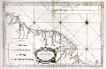 | Details | Depot de la Marine | 1760 |
| Antique French sea chart of South America south of the Orinoco River |
|
Depot de la Marine |
|
| 1760 |
| LOC:67 |
| $475.00 | Depot-de-la-Marine | Antique-French-sea-chart-of-South-America-south-of-the-Orinoco-River | Original, 254 year-old antique working nautical chart of the east coast of South America including parts of Venezuela, Guyana, Suriname, French Guiana and Brazil. Coverage on this large French sea-chart includes a large area between the Orinoco (Grande Embouchure de l'Orenoque) and Amazon rivers that was once collectively known as "Guyane", a term derived from an indigenous word meaning "land of many waters". Named geographical features include Nouvelle Middelbourg, Fort de Nouvelle Zeeland, Cap de Nassau, Essequibo River, a settlement along the Essequibo labeled simply "le Bourg", Demerary River, Berbiche River, Port Nassau, Corentin River, Suriname River, Paramaribo and Nouvelle Amsterdam, Maurany River, Devils' Islands (Isles au Diable), Oyapoque River, Counany River, Cayenne, St. Paul Mission, Cap d'Orange, and Cap de Nord.
<br></br>
Numerous depth soundings, anchorages, hazards, and offshore details are noted. Some interior detail including rudimentary roads, missions, and guard posts are shown in French Guiana.
<br></br>
As denoted on the chart coverage area extends southward from Venezuela (Guyane Espagnole), Guyana and Suriname (Guyane Hollandoise) to French Guiana (Guyane Francoise) and Brazil (Guyane Portugaise). Inset at top right contains a elevation plan of the coast in the vicinity of Cayenne, the capital of French Guiana. Inset at bottom left contains profiles of headlands seen when approaching Cayenne and Cap d'Orange from the sea.
<br></br>
By Nicolas Bellin in 1760, working for France's Depot des Cartes et Plans de la Marine. At this later stage of his career Bellin's extensive experience as a cartographer is evidenced by the attribution within the large decorative cartouche: "Par le S, Bellin Ingenieur de la Marine, Censeur Royal de l'Academie de Marine, et de la Societe Royal de Londres."
<br></br>
With the circular anchor logo of the Depot de la Marine. |
| 3650 | 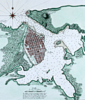 | Details | Depot de la Marine | 1762 |
| Antique French harbor chart of Havana, Cuba |
|
Depot de la Marine |
|
| 1762 |
| LOC:51 |
| $1,350.00 | Depot-de-la-Marine | Antique-French-harbor-chart-of-Havana--Cuba | Striking, original harbor chart and plan of the bay, town and forts of Havana, Cuba as they existed before 1762. Bellin identifies forty-five important locations in and around Havana and denotes their location on the plan alphabetically. Created by order of the Duc du Choiseul, French Minister of War.
<br></br>
With three inset plans "Le Fort du Maure" (Morro Castle, or more correctly- Castillo de los Tres Reyes del Morro), Fort de la Pointe (Castillo de San Salvador de la Punta), and Le Vieux Chateau (Castillo de la Real Fuerza) with 22 pieces of cannon. In 1762, after the Siege of Havana, the British captured all of Havana including the forts. All were returned to Spain a year later under terms of the Treaty of Paris.
<br></br>
This fine antique chart is from Nicolas Bellin, 1762, working for France's Depot des Cartes et Plans de la Marine.
<br></br>
With the circular anchor logo of the Depot de la Marine. Price when issued dix huit (18) Sols. No. 69. |
| 502 |  | Details | Depot de la Marine | 1763 |
| Plan de l'ile de Saint Pierre au Sud De Terre-Neuve |
|
Depot de la Marine |
|
| 1763 |
| LOC:65 |
| $550.00 | Depot-de-la-Marine | Plan-de-l-ile-de-Saint-Pierre-au-Sud-De-Terre-Neuve | Antique French sea chart of the island of Saint Pierre about 25 miles south of Newfoundland, in the northwestern Atlantic Ocean.. Lying just offshore of Saint Pierre are numerous smaller islands including Le Grand Colombier; Isle aux Chiens, Isle aux Pigeons, and the gruesomely named "Isle Massacre". The small village is referred to as "le Bourg".
<BR> </BR>
Several features on this chart suggest it was rushed into production. These features include numerous small rectangular areas where the engraving had been smoothed and then re-engraved with place names or descriptors, and at least one area where the chart was smoothed but then left blank. These new additions include "Teste de Galantry"; "Broussailles" ( Fr. Brush wood); and "Bois de Chaufage" (Fr. Heating wood).
<BR> </BR>
In the year this chart was published, 1763, under the terms of the Treaty of Paris, France ceded all its North American possessions, but Saint-Pierre and Miquelon were returned to France. Saint Pierre and Miquelon is today a self-governing overseas territory of France.
<BR> </BR>
Large decorative title cartouche at bottom left is adorned with garlands. Rhumb lines extend from a simple compass rose at right. At bottom right the anchor stamp of the Depot de la Marine and a later red hand-stamp of the "Military Depot" containing the royal coat of arms of the United Kingdom: a shield and crown flanked by a lion and unicorn. |
| 1049 |  | Details | Depot de la Marine | 1774 |
| Large antique French sea chart of the Caribbean and Gulf of Mexico |
|
Depot de la Marine |
|
| 1774 |
| LOC:61 |
| $1,750.00 | Depot-de-la-Marine | Large-antique-French-sea-chart-of-the-Caribbean-and-Gulf-of-Mexico | Beautiful second edition (1774) of Bellin's important map of the Caribbean, Central America, and Gulf Coast, which is substantially revised and updated from the first edition issued by Bellin in 1749. Most notable feature on this stunning 18th century survivor is that south Florida is depicted as a mass of islands. The concept of the Florida archipelago derives from the work of Father Francois Le Maire, a missionary who arrived in Louisiana in June 1706.
<br></br>
In the title block the date has been partially erased from the original plate, causing some confusion that this chart might date to the 17th year of the French Revolution (1806). This is not the case. The attribution to the Duc du Paslin, the lack of R.F. in the circular Depot logo, and the depiction of Florida as an archipelago are all consistent with the Library of Congress' date for this map of 1774. (Library of Congress Map Diivision. "A List of Maps of America in the Library of Congress". 1901. p. 423. Retrieved online 3/2016) |
| 754 |  | Details | Depot de la Marine | 1775 |
| Antique French nautical chart of the eastern Bahamas and the Antilles |
|
Depot de la Marine |
|
| 1775 |
| LOC:0 |
| $0.00 | Depot-de-la-Marine | Antique-French-nautical-chart-of-the-eastern-Bahamas-and-the-Antilles | SOLD
<br></br>
Two antique French nautical charts of the Bahamas and Antilles islands. Dated to 1775 within both title cartouches and attributed to French Naval Captain Jean Rene-Antoine Verdun De La Crenne (1741-1805), Alexandre Guy Pingre, and Jean-Charles de Borda.
<br></br>
Both copper-plate engraved charts printed in a single impression on one large sheet of heavy wove paper. Soundings and navigational hazards noted on the charts attest to their expected use aboard ships of the French Navy.
<br></br>
Lower chart includes eastern Cuba (including Baracoa); the eastern Bahama islands; the Turks (les iles Turques) and Caicos Islands (Gran de Cayque de Nord); and the northwest portion of the island of Hispaniola (partie de l'Ile de St. Dominque). Within the Bahamas coverage includes part of Long Island, Rum Cay, (Wattelin) San Salvador Island, Crooked Island, Mayaguana, Little Inagua Island, and Inagua Island.
<br></br>
Upper chart of the Lesser Antilles extends from eastern Puerto Rico through the Leeward and Windward Islands. Coverage includes the Virgin Islands with Saint Croix, Saint John, and Saint Thomas; and the islands of St. Kitts, Nevis, Anguilla, St. Martin, St. Barts, Barbuda, Antigua, Montserrat, Guadeloupe, Marie-Galante, la Desirade, Dominica, Martinique, St. Lucia, Barbados, and St. Vincent. |
| 748 | 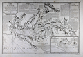 | Details | Depot de la Marine | 1778 |
| 1778 Chesapeake Bay Sea Chart after Anthony Smith |
|
Depot de la Marine |
|
| 1778 |
| LOC:53 |
| $3,900.00 | Depot-de-la-Marine | 1778-Chesapeake-Bay-Sea-Chart-after-Anthony-Smith | Large antique nautical chart from the Revolutionary War period of Chesapeake Bay and associated waterways in Maryland and Virginia. The first state of two in the French edition of Anthony Smith's influential and detailed chart of the Chesapeake Bay, Delmarva Peninsula, and surrounding waterways. Coverage includes the towns of Baltimore, Annapolis, Alexandria, Colchester, and James Town. Noted waterways include the Choptank River, Rappahannock River, Pocomoke ( "Pokomack" ) River, Potomac ( "Pawtomack" ) River, and Patapsco River.
<br></br>
Published by the French Depot de la Marine under the auspices of Antoine de Sartine during a period in which he served King Louis XVI as Secretary of the Navy. Text and notes are in French- for example below the town of Norfolk, Virginia is the note <b>"brule en 1776" </b>. That refers to the bombardment of Norfolk with red-hot shot by British naval forces, led by Lord Dunmore. Due to the shelling, British landing parties, and local British patriot forces, Norfolk was totally destroyed between January 1 - 3, 1776.
<br></br>
This first state is differentiated from the second state by the lack of added scrollwork around many of the text blocks and much less stippling of the land masses than in the second state. These decorative flourishes could have easily been added at a later date.
<br></br>
This chart was likely offered for sale individually but was also available as one of 13 full sheets and 5 half sheets published by the Depot de la Marine in the atlas "Neptune Americo-Septentrional contenant les côtes, les et bancs, iles baies, ports, et mouillages, et les sondes des mers de cette-partie du monde, depuis le Groenland inclusivement, jusques et compris le golfe du Mexique." Contains an inset plan of Herring Bay Maryland. |
| 45 |  | Details | Depot de la Marine | 1790 |
| Carte Reduite de Golfe de Gascogne |
|
Depot de la Marine |
|
| 1790 |
| LOC:0 |
| $0.00 | Depot-de-la-Marine | Carte-Reduite-de-Golfe-de-Gascogne | SOLD
<br></br>
Large, no-nonsense antique copperplate engraved navigational chart on wove paper. Coverage is of the Gulf of Gascogne from Isle d'Ouessant to Cape Finisterre.
<br></br>
Published by the French Depot de la Marine in 1790. |
| 1011 |  | Details | Depot de la Marine | 1791 |
| French Chart of the Azores Island, Portugal |
|
Depot de la Marine |
|
| 1791 |
| LOC:54 |
| $750.00 | Depot-de-la-Marine | French-Chart-of-the-Azores-Island--Portugal | Antique chart from 1791 of the Azores Islands, off the coast of Portugal. This chart "Carte réduite des Isles Açores" is a 1791 French sea chart based on the earlier observations of Tofino de San Miguel, of the Spanish Admiralty. Contains numerous elevation profile views of the Azores coastline as seen from sea. Coverage inccludes the islands of Corvo, Flores, Graciosa ("Gracieuse"), Terceira, São Jorge, Pico, Faial, São Miguel, and Santa Maria. |
| 636 |  | Details | Depot de la Marine | 1793 |
| Cote Meridionale d'Espagne depuis Cadiz jusqu'au Cap de Palos |
|
Depot de la Marine |
|
| 1793 |
| LOC:0 |
| $900.00 | Depot-de-la-Marine | Cote-Meridionale-d-Espagne-depuis-Cadiz-jusqu-au-Cap-de-Palos | Exceptional antique French nautical chart of the Western Mediterranean Sea, including the southern coasts of Spain and France and the northern coast of Africa. Nearly perfect condition. Coverage on this handsome folding sea chart extends from Cadiz, Spain eastward past Cape Trafalgar, Gibraltar, Malaga, Cartagena, to Cape Palos. Hundreds of named towns, villages, and geographic features ring the coastline with depth soundings, but virtually no interior details. Latitude and longitude scales.
<br><br/>
With the circular stamp of the French Depot de la Marine. Price when issued: Three Francs. No. 93.
<br><br/>
Exterior of the original linen cover contains a decorative octagonal seller's label: "Ch. Piquet, Geographe ordinaire DU ROI et de S.A.R. Monseig(neur) le Duc d'Orleans. A Paris Quai de Conti No. 17, entre l'Hotel des Monnaies et le Pont des Arts." |
| 1263 |  | Details | Depot de la Marine | 1798 |
| Antique French chart of the mouth of the Humber River in England |
|
Depot de la Marine |
|
| 1798 |
| LOC:0 |
| $465.00 | Depot-de-la-Marine | Antique-French-chart-of-the-mouth-of-the-Humber-River-in-England | Antique nautical chart includes some of the west coast of England with portions of Norfolk and Lincolnshire counties. Points charted on this old nautical artifact extend from Lowestoff in the south past Yarmouth, Lynn Regis, Wainfleet and Saltfleet; terminating in the north past Grimsby.
<br></br>
With the circular logo of France's Depot de la Marine with "R.F." used during the period immdiately after of the French Revolution . |
| 855 | 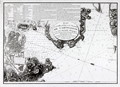 | Details | Depot de la Marine | 1799 |
| Old nautical chart of the harbor and town of Cartagena, Spain |
|
Depot de la Marine |
|
| 1799 |
| LOC:8 |
| $600.00 | Depot-de-la-Marine | Old-nautical-chart-of-the-harbor-and-town-of-Cartagena--Spain | Attractive antique harbor chart of Cartagena ( Carthagene ), Spain derived from the surveys of Admiral Don Vincente Tofiño de San Miguel. Noted geographical features of this plan of the port city of Cartagena on Spain's Mediterranean coast include Escombrera Bay ( Ensenada de Escombreras ) and Escombrera Island, Cartagena Harbor, "Montagne des Maures" ( Cerro de los Moros ) , "Petit Algameque" ( Algameca Chica ) , Plage des Chaloupes, and Cap Negrete.
<br></br>
Based on Tofino de San Miguel's chart which was originally published from Spain in the Atlas Maritimo de España in 1789. This later French edition was published by the French Depot General des Cartes et Plans in year 8 of the French revolution which dates it to roughly 1799 - 1800.
<br></br>
The chart contains much detail of both the terrain, local fortifications, and hydrographical features. A legend at top left contains several dozen entries keyed to military, religious, and secular locations of importance. Among these are "le Catedrale"- the cathedral; "Le Bagne"- the prison; "Depot de bois dans l'eau"- a series of connected pond-like pools near the shipyard where planking, spars and other lumber used in shipbuilding could be seasoned in water; "Pompe a Feu" - the fire pump; and numerous other entries. Sailing directions at top right. All text is in French. |
| 1119 | 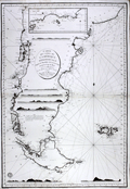 | Details | Depot de la Marine | 1800 |
| Antique French Sea Chart of Patagonia in South America |
|
Depot de la Marine |
|
| 1800 |
| LOC:51 |
| $1,450.00 | Depot-de-la-Marine | Antique-French-Sea-Chart-of-Patagonia-in-South-America | An attractive large antique French sea chart of Patagonia in lower South America published by France's Depot de la Marine in 1800. This spectacular chart encompasses the southern half of South America. With part or all of what is today Argentina, and Chile and includes the Falkland Islands. The map, as noted in the cartouche, is based on charts or surveys published in 1789, 1790, etc. by officers of the Spanish Navy.
<br></br>
In a few areas where information about the coast was scarce or completely lacking, the coastline is drawn using a very light line with no shading. For example, the "Canal de St. Sebastien" shown on the chart in the upper part of Tierra del Fuego (Fr. "Terre de Feu") near the Bay of St. Sebastien was completely without basis in fact and its questionable existence is communicated by the use of thin lines on both the north and south limits of that feature.
<br></br>
At top is an inset map of the north part of Golfe de St. George showing Isla Tova. This spectacular chart also contains seven very attractive coastal elevation views that would aid navigators as they approached shore:
<div class="indenttextblock">
<ul>
<span style= style="list-style-type: circle;">
<li>Vue de l'IIe de la Mocha</li>
<li>Vue du Cap Blanc</li>
<li>Vue de 'Entrée du Port Desire</li>
<li>Vue du Cap de 3 Pointes</li>
<li>Vue des Iles Salvages</li>
<li>Vue des Iles de Diego Ramirez</li>
<li>Vue du Cap de Horn</li>
</span>
</ul>
</div>
"Prix Trois Francs" at bottom right. Logo of the Depot de la Marine in the lower left of the map. |
| 3602 |  | Details | Depot de la Marine | 1801 |
| Antique French sea chart of northern Cuba and the Bahamas |
|
Depot de la Marine |
|
| 1801 |
| LOC:51 |
| $700.00 | Depot-de-la-Marine | Antique-French-sea-chart-of-northern-Cuba-and-the-Bahamas | Authentic, old French nautical chart, an attractive antique engraving with hand coloring ca. 1801.
Inset plans include:
<div class="indenttextblock">"Plan du Mouillage que forment les Cayesde Piedra, Mono, Monillo et autres ajacentes."</div>
<div class="indenttextblock">"Plan du Mouillage que forment les Cayes Verde et Confites."
<br></br>
French antique navigation chart of the "Vieux Canal" or old canal of the Bahamas. Other features (in French) include Canal de Santarem and Banc de Los Rocques. Inset chart of the anchorage near Cayo Blanco ("les Cayes de Piedras, Monillo, et autres ajacentes") and of the anchorage at Cayo Verde and Cayo Confites. Circular logo of the Depot de la Marine.
<br></br>
"Carte Reduite d'Une Partie du Vieux Canal de Bahama st des Bancs Adjacents". Dated "l'An X" (10th year of the Revolutionary calendar). Published in Paris. |
| 1470 |  | Details | Depot de la Marine | 1801 |
| French antique chart of the Bahamas old channel and northern Cuba |
|
Depot de la Marine |
|
| 1801 |
| LOC:67 |
| $489.00 | Depot-de-la-Marine | French-antique-chart-of-the-Bahamas-old-channel-and-northern-Cuba | French antique navigation chart of the "Vieux Canal" or old canal of the Bahamas. Other features (in French) include Canal de Santarem and Banc de Los Rocques. Inset chart of the anchorage near Cayo Blanco ("les Cayes de Piedras, Monillo, et autres ajacentes") and of the anchorage at Cayo Verde and Cayo Confites. Circular logo of the Depot de la Marine. |
| 1084 | 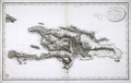 | Details | Depot de la Marine | 1803 |
| Antique French Chart of the Dominican Republic and Haiti |
|
Depot de la Marine |
|
| 1803 |
| LOC:51 |
| $750.00 | Depot-de-la-Marine | Antique-French-Chart-of-the-Dominican-Republic-and-Haiti | Old French map of Saint Dominque- the island of Hispaniola not yet divided into political entities of Haiti and the Dominican Republic. Topography is shown in relief with extensive shading and hachuring. There is extensive depiction of the roads, rivers, and towns that populate the interior of the island. While the map does provide the user with visual geographic details, the is no information either of elevation of the terrain, nor are there any depth soundings.
<br</br>
The map was published by the Depot de la Marine in "An XI" - the 11th year after the French Revolution of 1803. Two changes on the map from an earlier edition of the same map published before the revolution are that the Depot de la Marine logo incorporates the letters "R.F." (Republique francaise) and the town previously denoted as "Port au Prince" is called "Port Republicain" in the post-revolutionary edition. |
| 897 | 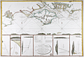 | Details | Depot de la Marine | 1803 |
| Attractive antique chart of the Isle of Wight and Portsmouth, England |
|
Depot de la Marine |
|
| 1803 |
| LOC:64 |
| $720.00 | Depot-de-la-Marine | Attractive-antique-chart-of-the-Isle-of-Wight-and-Portsmouth--England | Attractive French copperplate engraved sea chart of the <b>Isle of Wight</b> and Hampshire coast of England after a chart of 1800 by Captain William Price. This spectacular antique chart is packed with interesting observations that are now over 200 years old. On the main, upper chart numerous soundings, buoys, current indicators, and sandbanks are displayed along with seven inset coastal recognition elevation views to include the Needles, Ash Down Beacon, and Dunnose.
<br></br>
Towns, villages, and other noted features include: St. Aldan's Head, Poole, Christ-church, Lymington, Portsmouth, Portchester, Brackelsome Bay, Chelsea Bill, Brading, Blackgang Chin, Wacht House, Spithead, Sandown Bay, Chichester, and Cowes.
<br></br>
Central inset contains an oval title cartouche and a description of local buoys with the water depths at each. These named buoys include <b>Royal George</b> (a first-rate British ship-of-the-line lost off Portsmouth while at anchor in August 1782) , Edgar, Normansland, Bembridge Ledge, Knab Rock and the Horse and Dean Sands. Flanking the central inset are five attractive detailed elevation views with bearings <b>triangulating buoys to on-shore features</b>, usually prominent houses, beacons, or hills. These bearings are often accompanied with sailing directions in French such as this one indicating an anchorage with a 3-masted sailing ship at anchor. It triangulates a compass heading with a white marker on the Isle of Wight to a windmill on Portsea Island. <div class="indenttextblock"> "La Chapelle dans Portsmouth Common et le Moulin dans l'est du Chateau de South Sea l'un par l'autre N 14 NE".</div>
</br>
Published by order of Contre-Amiral (Rear Admiral) Decres in An XII (year 12) of the French Revolution which is equivalent to 1803. With the circular logo of an anchor surrounded by "R.F." (REPUBLIQUE FRANÇAISE) used by the Depot during the revolution. Price when published was two Francs. |
| 593 |  | Details | Depot de la Marine | 1804 |
| Plan du Port de Plymouth |
|
Depot de la Marine |
|
| 1804 |
| LOC:64 |
| $860.00 | Depot-de-la-Marine | Plan-du-Port-de-Plymouth | Neat chart of the harbor and town of Plymouth, England published in the 12th year of the French Revolution (1804). With shaded topographical details, numerous soundings, defensive structures, and navigational aids. Single profile view of the entrance to Plymouth Sound at top right.
<br></br>
Named features include Ram Head, Redden Point, Point Penlee, Saltash, Tamer River, Line River, East Anthony, Stoke Damerel, Plymouth, Sutton Pool, Mount Batten, Catwater, Causand Bay, Shagstone, Mewstone, Yealme River, Mill Bay, Drakes Island, and many more.
<br></br> Black and white copperplate-engraved chart was published by France's Depot de la Marine. With the circular anchor stamp of the Depot. Original price was one and one-half francs. |
| 524 | 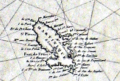 | Details | Depot de la Marine | 1806 |
| Carte Generale des Isles Antilles |
|
Depot de la Marine |
|
| 1806 |
| LOC:51 |
| $775.00 | Depot-de-la-Marine | Carte-Generale-des-Isles-Antilles | Large, rolled, copperplate engraved antique 'brown-back' working sea chart of the Caribbean (Antilles) issued by the French Depot de la Marine in 1806. Coverage includes from eastern Puerto Rico and its islands of Culebra and Vieques, the British Virgin Islands, Anguilla, St. Kitts, Nevis, Montserrat, Antigua, Barbuda, Guadeloupe, Dominica, Martinique, St. Lucia, St. Vincent, Grenada, Barbados, Trinidad and Tobago to the Venezuelan coast. The lower portion of the map covers the northern coast of Venezuela including the cities of Cumana and Barcelona. Numerous French place names, soundings and navigation hazards are noted.
<BR> </BR>
Chart is covered with brown linen; probably contemporary to its issue based on the wear pattern. Blueback charts, covered in blue linen, or heavy paper are much more common, These brown back charts are not often found. The linen has done a good job of protecting the map and maintaining it's fine condition over the last 200+ years.
<BR> </BR>
With the circular stamp of the French Depot de la Marine. No 187. Price 3 Francs. |
| 622 | 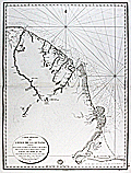 | Details | Depot de la Marine | 1817 |
| Mouth of the Amazon River with Coastal French Guiana and Suriname |
|
Depot de la Marine |
|
| 1817 |
| LOC:67 |
| $1,300.00 | Depot-de-la-Marine | Mouth-of-the-Amazon-River-with-Coastal-French-Guiana-and-Suriname |
Original 1817 French nautical chart titled Carte reduite des cotes de la Guyane comprises entre les bouches de la riviere des Amazones et celles du Maroni, issued by the Depot de la Marine. The chart depicts the mouth of the Amazon River from Rio Araguari southward and extends north along the coasts of Brazil into French Guiana and Suriname as far as the Maroni River. Engraved on thick chain-laid paper, the sheet bears the circular stamp of the French hydrographic service and reflects official early nineteenth century maritime survey work.<br><br>
The map records numerous coastal and riverine features, native villages, missionary sites, and geographic landmarks as known at the time. Place names include Cayenne, Kourou, St. Paul, Cape Orange, and Mt. Tripoupou, with interior village references near the Tumuk Humac mountains. Notation on the chart reflects the limited European penetration of the interior during this period, consistent with contemporary exploration accounts such as those of Alexander von Humboldt. Soundings, offshore islands, and coastal configuration are shown throughout, emphasizing navigational utility.<br><br>
Charts issued by the Depot de la Marine formed the core of French naval hydrography during the early nineteenth century and remain important records of Atlantic coastal surveying. Early examples in original state are increasingly scarce. This sheet offers documentary value for collectors focused on South American exploration, colonial maritime networks, and the technical development of European hydrographic mapping.<br><br> |
| 525 | 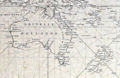 | Details | Depot de la Marine | 1818 |
| Carte Reduite du Grand Ocean comprise L'Asie et L'Amerique |
|
Depot de la Marine |
|
| 1818 |
| LOC:0 |
| $0.00 | Depot-de-la-Marine | Carte-Reduite-du-Grand-Ocean-comprise-L-Asie-et-L-Amerique | SOLD
<br><br/>
Antique rare 'brown-back' navigation chart issued by the French Depot de la Marine in 1818. Coverage extends from Sumatra in the far west to the Antilles and Gulf of Mexico. Includes: Vietnam, Korea, Philippines, Japan, Australia (Nouvelle Hollande), New Zealand, the "Sandwich Islands" [Hawaii (Owhywi) , Mowi, Oahu (Woahua)...], Easter Island (Isle de Paques), Port St Francois (San Francisco), California and most of the Pacific Islands. <br><br/>
With the circular stamp of the Depot General de la Marine at bottom left. Chart is covered with brown linen; probably contemporary to its issue based on the wear pattern. No. 420. Price 2 Francs. |
| 624 | 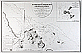 | Details | Depot de la Marine | 1822 |
| Mouth of Cayenne River, French Guiana and Anchorages |
|
Depot de la Marine |
|
| 1822 |
| LOC:0 |
| $0.00 | Depot-de-la-Marine | Mouth-of-Cayenne-River--French-Guiana-and-Anchorages | SOLD <br></br>
Large antique nautical chart of the mouth of the Cayenne River, the town of Cayenne, French Guiana and the surrounding coastline and offshore environs. Coverage centers on the island and town of Cayenne with numerous soundings and some hachured topographical relief. This excellent original copper-plate engraved sea chart includes the mouths of the Mahury and Cayenne Rivers, Mt. Cabasson, Mt. des Tigres, Mt. Dupont, Mt. de Mahury, Rentontabo, Pointe du Diamant ( Diamond Point ), and the islands of Malingre, Le Pere, La Mere, and Les Mamelles, and alone about 5 miles offshore, L'Enfant Perdue (Lost Child ). <br></br>
Issued by the French Depot de la Marine and containing the circular mark of that body at lower left within an "Avertissement" containing sailing directions. Engraved by Ambroise Tardieu.<br></br>
Inset at upper right of the "Plan des Isles du Salut", a French penal colony in the mid 19th century. Features Ile du Diable, Ile St. Joseph, and Ile Royale. Of these Ile du Diable is the infamous Devil's Island, designated for political prisoners and featured in the 20th century film 'Papillion', starring Steve McQueen and Dustin Hoffman. No 199 with a later stamp "29" in red. Dated within oval cartouche to 1822. |
| 661 |  | Details | Depot de la Marine | 1822 |
| Plan of Saint George's Bay Newfoundland |
|
Depot de la Marine |
|
| 1822 |
| LOC:65 |
| $375.00 | Depot-de-la-Marine | Plan-of-Saint-George-s-Bay-Newfoundland | Beautiful copperplate-engraved chart of the interior of St. George's Bay near the present-day towns of Stephenville and Saint George's on the Southwest coast of Newfoundland. Early 19th century working sea chart of area near the Gulf of St. Lawrence produced by the French Depot de la Marine after the work of two French Naval officers: Saulnier de Vauhello and Begon de la Rouziere. Noted points of interest include Cap Sauvage, Flat Island ( Point de Sable ), and Riviere Saint George. Numerous soundings and hydrographical features.
<br></br>
With the circular logo of France's Depot General de la Marine. Price Two Francs. No. 148. |
| 4787 | 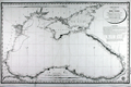 | Details | Depot de la Marine | 1823 |
| Antique Nautical Chart of the Black Sea Azof Sea Crimea |
|
Depot de la Marine |
|
| 1823 |
| LOC:62 |
| $2,200.00 | Depot-de-la-Marine | Antique-Nautical-Chart-of-the-Black-Sea-Azof-Sea-Crimea | A foundational sea chart for collectors of the Black Sea and Azoff Sea with the track of the French survey vessel "Chevrette" during their survey cruise in 1820.
<br><br/>
A fine, scarce copper-plate engraved hydrographic chart of the Black Sea and Sea of Azov (Azof). This ~200 year-old artifact documents the hydrographic survey of Captain Pierre-Henry Gauttier with Benoist and others during their cruise aboard the gabare "Chevrette" in 1820 to the Sea of Marmara and the Black Sea.
<br></br>
Before the Black Sea survey, in 1818/1819 Gauttier conducted a survey to Greece with Jules Sébastien César Dumont d'Urville (1790-1842), where d'Urville played a role in bringing the statue of Venus from the island of Milos to the Louvre. Long story short, though d'Urville's importance in the affair appears to have been secondary, skillful PR hyped d'Urville's importance and the "discovery" of the Venus de Milo launched his young career as a botanist and hydrographer.
<br></br>
Pierre-Henry Gauttier du Parc (1772 - 1850) was a French naval officer and hydrographer.
<br></br>
Engraved by Etienne Collin (1770, 1841). A brief biography explains that Etienne Collin was the nephew of the renowned Beautemps-Beaupre, considered to be the <b>father of French hydrography</b>. The biographer noted Beautemps-Beaupre practiced an "enlightened nepotism" and that during Beaupre's tenure as Hydrographer "that the functions (geographers, hydrographers, engravers, draughtsmen, ....) within the Depot were largely occupied by members of the Buache-Beautemps-Collin family." (Source: http://cartes-martinique.pagesperso-orange.fr/Graveurs_HydroFran.htm)
<br></br>
With the circular logo of the Depot General de la Marine. Price when issued 4 Francs. |
| 605 | 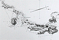 | Details | Depot de la Marine | 1823 |
| Plan du Golfe de Santa Manza |
|
Depot de la Marine |
|
| 1823 |
| LOC:66 |
| $500.00 | Depot-de-la-Marine | Plan-du-Golfe-de--Santa-Manza | Lovely antique chart of the Gulf of Santa Manza, on the southeast coast of Corsica ( Corse ), France near the town of Bonifacio with numerous soundings and coastal topographic details. Beautifully executed and finely detailed engraving in near-perfect condition. Noted features include: Port de Santa Manza, Iles de Porraja, Cap Capicciolo, Cap Blanc, Cap Rondinara, Port de la Rondinara, Calanque de Carlo Anto, Tour de Sponsaglia, Mt. Carpice, amd Porto Nuovo. At top, and extending the full width is a beautifully engraved view of the coastline that includes all the points above and many more.<br></br>
This large, original copperplate nautical chart was issued by the French Depot de la Marine in 1823 and bears the circular stamp of that agency. Engraved by Ambroise Tardieu. With the circular stamp of three fleur-de-lis surrounding an anchor, from the Depot General de la Marine. |
| 884 | 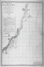 | Details | Depot de la Marine | 1824 |
| Antique chart of Brazilian east coast north of Cabo Frio |
|
Depot de la Marine |
|
| 1824 |
| LOC:67 |
| $500.00 | Depot-de-la-Marine | Antique-chart-of-Brazilian-east-coast-north-of-Cabo-Frio | Antique French sea chart issued in 1824 extends over approximately 800 miles of the east coast of Brazil and incudes portions of the State of Rio de Janeiro and the State of Espirito Santo. Coverage on this old chart starts about 80 miles to the east of Rio de Janeiro near Cabo Frio and trends generally north-northeast past Cabo de São Tomé, Vitoria, Rio Doce and Porto Seguro, ending north of Santo Andre. Little interior details are shown but the chart does identify several mountainous features that may have been visible from sea including the Pic ou Frade de Maccahe, Mt. de Campos, Mt. Mestre Alvaro, and Mont Pascoal.
<br></br>
Tracks are recorded for the two French vessels that conducted explorations and soundings of the area on this chart: the Corvette "la Bayadere" and the Brick "le Favori". Contains an avertissment below the title block with notes, warnings, and observations useful to mariners.
<br></br>
With the circular logo of the Depot Generale de la Marine. All text in French. No. 408. |
| 4780 | 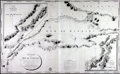 | Details | Depot de la Marine | 1826 |
| Antique Chart Marmara, Dardanelles, Istanbul |
|
Depot de la Marine |
|
| 1826 |
| LOC:66 |
| $2,500.00 | Depot-de-la-Marine | Antique-Chart-Marmara--Dardanelles--Istanbul | Very scarce and wonderfully-engraved French sea chart of the Sea of Marmara, the Dardenelles, Istanbul (Constantinople), the Bosporus, and southern Black Sea from 1826. Depth soundings on this large antique navigational chart extend from the island of Tenedos in the Aegean Sea through the Dardenelles and the Sea of Marmara, up the Bosporus to Istanbul and then into the Black Sea (Mer Noire).
<br></br>
Dedicated to Christophe de Chabrol de Crouzol, Minister of the French Navy from 1824-1829. This supports our date of 1826 though the middle two characters in the date have been effaced leaving only (1--6).
<br></br>
With a large inset chart by Kauffer of the walled city of Constantinople, Turkey and the entire Bosporus and a second inset chart with the Hellespont and Dardenelles by le Comte de Truguet.
<br></br>
<img src="/PageImages/Marmara_Bellin_1772.jpg" alt="Bellin 1772 chart of the Sea of Marmara." width="140" align="left" style="margin: 0px 10px"> No copy of this chart is found online, nor in the AMPR, while 11 sales are recorded of Bellin's earlier "Carte de la Mer de Marmara" at left.
<br></br>
A brief biography in French explains that Etienne Collin, engraver of this work, was the nephew of the renowned Beautemps-Beaupre, considered to be the father of French hydrography. Beautemps-Beaupre practiced an "enlightened nepotism". The biography notes during Beaupre's tenure as Hydrographer "that the functions (geographers, hydrographers, engravers, Cimetiere, ....) within the Depot were largely occupied by members of the Buache-Beautemps-Collin family."
<div class="indenttextblock">
"Etienne Collin (1770, 1841) né à la Neuville-au-Pont. Cousin de Beautemps-Beaupré, il est recruté par le célèbre hydrographe qui pratique un certain népotisme éclairé" ... (Source: http://cartes-martinique.pagesperso-orange.fr/Graveurs_HydroFran.htm)
</div> |
| 620 | 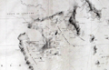 | Details | Depot de la Marine | 1827 |
| Southern Aegean Archipelago |
|
Depot de la Marine |
|
| 1827 |
| LOC:0 |
| | Depot-de-la-Marine | Southern-Aegean-Archipelago | SOLD
<BR></BR>
Antique French nautical chart of the coast and the islands of the Southern Aegean Sea from 1827. Geographic features covered by this antique chart include these locations in Greece and Turkey: Athens, Corinth, Izmir ( Smyrna ), Kusadasi ( Scala-Nova ), Bodrum, the Cesme and Datca peninsulas, and the islands of: Chios, Delos, Mykonos, Santorini, Milos, Naxos, Rhodes, Kos, and Crete ( Candia ). This scarce 'brownback' chart was issued by the French Depot de la Marine and was lined with brown linen when sold to provide additional protection from the elements onboard ship.<br></br>
Very interesting intact sellers label on the verso ( displayed bottom left corner ) reads : "MAISTRE. Ancien oeuvre d' Antoine Roux. Hydrographe. A l'honneur de Prevenir Mssrs. Les Armateurs et capitanes Marins qu'il confectionne et remet a neuf lous le Instrumens de marine. Quai Rive l'avenue. MARSEILLE. Pres le Pharmacien."<br></br>
Attractive old engraved chart documenting the tracks of the exploration of that area by Gauttier in 1818 and 1819. Extensive fine hachuring of coastal mountains, some soundings, and no interior details. Dated to 1827 at bottom of the oval cartouche. With the circular stamp of the Depot General de la Marine. Attribution reads: "Publiée par Ordre du Roi sous le Ministère de Son Excellence M. le Comte Chabrol de Crousol. Dépôt Générale de la Marine." |
| 599 | 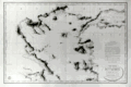 | Details | Depot de la Marine | 1827 |
| Northern Aegean Archipelago |
|
Depot de la Marine |
|
| 1827 |
| LOC:1403 |
| $1,750.00 | Depot-de-la-Marine | Northern-Aegean-Archipelago | Antique nautical chart of the coast and the islands of the northern Aegean Sea and the Sea of Marmara, including Constantinople, Turkey (modern Istanbul). Attractive old engraved chart documenting tracks of the exploration of that area. Extensive fine hachuring of coastal mountains, some soundings, and no interior details. At bottom of the inset 'avertissment' is found a legend dating each of the map's tracks to the year in which that exploration was conducted and identifying the abbreviations used by the authors for representing the composition of the sea bottom.
<br></br>
Geographical features covered by this antique chart include these locations in Greece and Turkey: Gulf of Corinth, Negroponte, Euboea ( the second largest Greek Island after Crete ), Skyros, Skiatos, Gulf of Salonica, the Dardanelles, Istanbul, Tenedos ( Bozcada ), Lemnos, Gulf of Smryne, Smyrne ( Smyrna ), Samos and much more.
<br></br>
An advertisement at right states that the chart is the result of hydrographic and geodesic work on land and aboard the gabare 'la Chevrette' during the years 1818 and 1819. <a href="https://fr.wikipedia.org/wiki/Gabare" target="_blank">A 'gabare'</a> is a French term for a three masted vessel of between 100 and 450 tons, typically used as a cargo carrier. Their heavy construction and capacity made them especially suitable for exploration and survey work.
<br></br>
Dated to 1827 at bottom of the oval cartouche. With the circular stamp of the Depot General de la Marine. Attribution reads: "Publiée par Ordre du Roi sous le Ministère de Son Excellence M. le Comte Chabrol de Crousol. Dépôt Générale de la Marine" Price when issued: two Francs. |
| 829 | 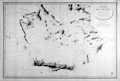 | Details | Depot de la Marine | 1827 |
| Southern Aegean Archipelago, Cyclades |
|
Depot de la Marine |
|
| 1827 |
| LOC:0 |
| $0.00 | Depot-de-la-Marine | Southern-Aegean-Archipelago--Cyclades | SOLD<br></br>
Antique French nautical chart of the coast and the islands of the Southern Aegean Sea from 1827 centered on the Cyclades islands with Crete, Greece ( Candie ) at bottom. Geographic features covered by this antique chart include these locations in Greece and Turkey: Athens, Corinth, Izmir ( "Smyrna" ), Kusadasi ( "Scala-Nova" ), Bodrum, the Cesme and Datca peninsulas, and the islands of: Chios, Delos, Kythira ( "Cerigo" ), also spelled Cythera, Kythera and Kithira ; Antikythira ( "Cerigotte" ), Mykonos, Santorini, Milos, Naxos, Rhodes, Kos, and Crete (and all the other islands surrounding).
<br></br>
This scarce chart was issued by the French Depot de la Marine. Attractive old engraved copperplate engraved chart documenting the tracks of the exploration of that area by Gauttier in 1818 and 1819. Extensive fine hachuring of coastal mountains, some soundings, and no interior details. Dated to 1827 at bottom of the oval cartouche. With the circular stamp of the Depot General de la Marine. Attribution reads: "Publiée par Ordre du Roi sous le Ministère de Son Excellence M. le Comte Chabrol de Crousol. Dépôt Générale de la Marine." |
| 319 |  | Details | Depot de la Marine | 1836 |
| Plan du port de Barfleur et de ses environs |
|
Depot de la Marine |
|
| 1836 |
| LOC:0 |
| $355.00 | Depot-de-la-Marine | Plan-du-port-de-Barfleur-et-de-ses-environs | Highly detailed antique nautical chart of the harbor and town of Barfleur, France and the surrounding coastline extending about 1.5 French mille marine to the north and south. Roads, fields, and very rocky offshore topography near the coast are depicted with great detail and relief. This graphic treasure captures the state of that stretch of coastline as it was in 1832 from the Pointe de Barfleur with its lighthouse to the north, past Anse Crabet and dozens of small islets, beyond the Plateau de Antiqueires and Plateau de Moulard to Anse de Landemer south of Barfleur. Nearby villages depicted include Monfarville, Quenanville, and Gatteville.<BR> </BR>
Manuscript notation of a cannon battery at the far east end of Barfleur harbor includes four red lines extending into the sea presumably marking the prospective firing angle and range of those cannon protecting the navigational channel. Circular stamp of Depot General de la Marine. Number 848. Price 2 francs. |
| 4753 | 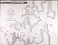 | Details | Depot de la Marine | 1837 |
| Early French-surveyed Chart of Sydney, Australia |
|
Depot de la Marine |
|
| 1837 |
| LOC:0 |
| $0.00 | Depot-de-la-Marine | Early-French-surveyed-Chart-of-Sydney--Australia | SOLD<br></br>
Fine first edition French Chart of the Harbor at <b>Sydney, Australia</b> (Port Jackson) based on surveys carried out by French Captain Bougainville . Baron Hyacinthe de Bougainville was the son of the famous French Pacific navigator Louis-Antoine de Bougainville. An officer of the French navy, in 1825 he commanded an expedition that took the ships Thetis and Esperance to Macau, Manila and New South Wales.
<br></br>
This French survey, by Baron de Bougainville, was the fourth state-sponsored delineation of the topography and hydrography of Port Jackson. Oval seller's stamp "Cercle Maritime. Brest".
<br></br>
The first depiction was after a compass survey conducted over just nine days by John Hunter and William Bradley, published by George Raper in 1791. During an expedition to the south-west coast of Australia, de Freycinet (1802) updated Hunter's chart with additional soundings from his own survey of Port Jackson. John Septimus Roe led the third survey in 1822 followed with this chart published in 1828 by French explorer Hyacinthe de Bougainville.
<br></br>
An original, treasured gift for anyone with interests in boating or sailing near Sydney. At top, a fine, engraved vue or "View of the Entrance to the Harbor at Port Jackson." Dated 1828 but 1837 with its publication as Plate 52 from:
<div class="indenttextblock">Journal de la navigation autour du globe de la fregate la Thetis et de la corvette l'Esperance pendant les annees 1824, 1825 et 1826 /Publie par ... M. le Baron de Bougainville. Paris : Arthus Bertrand, 1837. Grave par Ambroise Tardieu d'apres les dessins de M.E.B. de la Touanne, Lieutenant de Vaisseau. Ecrit par Besancon. Prix un franc.
</div></BR>
(Fr. Rare et grande carte marine de Port Jackson (Sydney, Australie) publiée par le Depot de la Marine de France.) Port Jackson, aussi appele Sydney Harbour, est le port naturel de Sydney en Australie.
<br></br>
Top left-hand corner: Voyage de la Thetis et de l'Esperance. |
| 316 |  | Details | Depot de la Marine | 1839 |
| Plan de l'embouchure de la Seine (environs du Harve) |
|
Depot de la Marine |
|
| 1839 |
| LOC:0 |
| $225.00 | Depot-de-la-Marine | Plan-de-l-embouchure-de-la-Seine--(environs-du-Harve) | Large antique chart covering the mouth of the Seine river with Villerville on the South bank and Le Havre and St. Adresse on the North bank. Le Havre fortress shown completely encircled with Vauban-type defensive walls. Locations of cannon batteries added in manuscript. This antique nautical chart has been profusely annotated in manuscript apparently by a member of the military or a military engineer. Numerous pencil notations in left and right margins with bearings. Red pen used to draw lines radiating from cannon batteries to delineate the expected range and line of fire. Numerous soundings. Circular stamp of Depot General de la Marine. No. 892. Price 2 francs. |
| 317 | 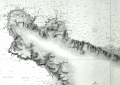 | Details | Depot de la Marine | 1839 |
| Carte Particuliere des Cotes de France (Cherbourg) |
|
Depot de la Marine |
|
| 1839 |
| LOC:0 |
| $210.00 | Depot-de-la-Marine | Carte-Particuliere-des-Cotes-de-France-(Cherbourg) | Attractive antique nautical chart (1839 ) of the environs around Cherbourg, France including Cape Hague and Cape Levi. Includes villages of Biville, Vauville, Auderville, Tonneville, Omonville, Greeville, Flottemanville, Querqueville, Henneville, Equerdeville, Toulaville, and Bretteville, and Cherbourg. The locations of several forts are noted and the cannon batteries and forts are named via script annotations in black ink. <BR> </BR>
This antique chart has been profusely annotated in manuscript apparently by a member of the military or a military engineer. Numerous pencil notations in left margin and top with bearings. Red pen used to draw lines radiating from cannon batteries to delineate the expected range and line of fire. Numerous soundings. Circular stamp of Depot General de la Marine. Price 2 francs. |
| 318 |  | Details | Depot de la Marine | 1841 |
| Carte Particuliere des Cotes de France (Cours de la Seine) |
|
Depot de la Marine |
|
| 1841 |
| LOC:0 |
| $375.00 | Depot-de-la-Marine | Carte-Particuliere-des-Cotes-de-France-(Cours-de-la-Seine) | Antique nautical chart of the Seine River with numerous soundings for the navigational channel. Villages include Guerbaville, Bliquetuit, Caudebec, Villequier, Aizier, Vieux Port, St. Aubin, Berville sur-mer, St. Opportune, Bouquelon, Conteville, St. Nicolas de-la-Taille, La Cerlangue, St. Vigor, Fiquetfleur, Tancarville, Rogerville, Gonfreville, St. Sauveire, Fatouville, and Honfleur. <BR> </BR>
Lower quarter of the nautical chart is dedicated to extensive remarks and a tide table. Numerous soundings and windmills are noted (moulin). Circular stamp of Depot General de la Marine. Number 949. Price 2 francs. |
| 1009 | 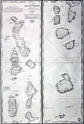 | Details | Depot de la Marine | 1841 |
| Antique French chart of the Maldive Islands |
|
Depot de la Marine |
|
| 1841 |
| LOC:0 |
| $0.00 | Depot-de-la-Marine | Antique-French-chart-of-the-Maldive-Islands | SOLD
<br></br>
Fine antique nautical chart of the Maldive islands, a island country and archipelago located in the Indian Ocean. This large old chart "Carte des Isles Maldives" was published by the French Depot de la Marine in 1841 (dated within) based on hydrographical data from Moresby and Powell, both officers in the British East India Company.
<br></br>
With a blue ink octagonal overstamp from the seller Antoine Roux, fils. (probably Mathieu-Antoine Roux 1799-1872) from Marseille, France. Roux was a hydrographer and painter with premises at "Quai Rive l'avenue Pres le Pharmacien in Marseille. " The Roux family was active in Marseille as hydrograpers and marine painters over at least three generations beginning with Joesph Roux. Number 942. |
| 326 |  | Details | Depot de la Marine | 1842 |
| Plan du port de Boulogne |
|
Depot de la Marine |
|
| 1842 |
| LOC:0 |
| $225.00 | Depot-de-la-Marine | Plan-du-port-de-Boulogne | Antique nautical chart published in 1842 covering the French port of Boulogne and nearby coastline. Circular stamp of Depot General de la Marine. |
| 885 | 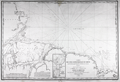 | Details | Depot de la Marine | 1842 |
| Antique chart of Brazilian coast and mouth of the Amazon River |
|
Depot de la Marine |
|
| 1842 |
| LOC:67 |
| $575.00 | Depot-de-la-Marine | Antique-chart-of-Brazilian-coast-and-mouth-of-the-Amazon-River | Antique French sea chart from 1842 covers the mouth of the <b>Amazon River</b> in Brazil. This fine large copper-plate engraved nautical chart begins north of the Amazon River near Isla Maraca and trends south then east to include Rio Araguari ( Araouari ) , Rio Amazonas, Ilha de Marajo, Para River, and the Ile de Maranham. Includes the towns of <b>Belem</b> (Para) , Sao Luis (San Luiz) , Macapa, Chaves, and numerous smaller villages. Includes an inset chart/plan of the Para River with Belem.
<br></br>
Dozens of smaller rivers and tributaries of the Amazon are identified by name along with hundreds of depth soundings in meters. After a lapse of 25 years France had recently re-adopted the metric system in 1837. At bottom left the authors provided a useful depth conversion table from meters to feet (pieds), and to the old measure of depth- brasses (about five feet).
<br></br>
With the circular logo of the <b>Depot Generale de la Marine</b>. All text in French. No. 408. |
| 1098 | 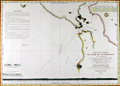 | Details | Depot de la Marine | 1843 |
| Scarce early French sea chart of San Francisco Bay |
|
Depot de la Marine |
|
| 1843 |
| LOC:63 |
| $1,450.00 | Depot-de-la-Marine | Scarce-early-French-sea-chart-of-San-Francisco-Bay | Scarce French sea chart of <b>San Francisco Bay</b> made during a voyage to the Pacific from 1836-39 by Captain Abel Aubert Du Petit-Thouars in command of the French Frigate <b>Venus</b>. The bay is well delineated with soundings and profile views. Shows the route taken in October 1837 by the Hawaiian ship "Kamamalou" (Captain William Sturgis Hinckley) as it ferried a crew from Petit-Thoaurs' Venus, who remained aboard the Venus in Monterrey Bay, to gather water and vegetables. The crew used that trip to reconnoiter the port of San Francisco.
<br ></br>
With several small and one large elevation profile view of the entrance to San Francisco Bay as seen from sea. The largest elevation view, at bottom, shows the coastline as seen from 25 miles offshore. That beautifully engraved profile extends from the <b>Farralon Islands</b> to well past "Cap Blanc" (Point San Pedro). The key feature of Alcatraz Island is labeled "I. aux Oiseaux" (Bird Island).
<br ></br>
A circled "+" between Alcatraz Island and Yerba Buena Island labeled "Basse du Seringapatnam" suggests that this is the site of a wreck of a vessel by that name. Going through the records we find a 398 ton whaling ship "Seragapatam" that sailed from Sydney and arrived in San Francisco on March 18, 1850.
<br ></br>
The motivation behind Petit-Thouars' exploration was France's interest in obtaining territory from the Mexican government in exchange for the millions of dollars worth of loans that the French government had given to Mexico, and which the Mexican government had defaulted on. France sent Captain Du Petit-Thouars to survey the region and see what it offered, as well as to project a French presence to bolster any claims they had in the Pacific.
<br></br>
Circular logo with an anchor from the Depot de la Marine. Plate 6. Number. 1002. |
| 179 |  | Details | Depot de la Marine | 1851 |
| Carte des Canaux de la Providence et de Bahama |
|
Depot de la Marine |
|
| 1851 |
| LOC:0 |
| $0.00 | Depot-de-la-Marine | Carte-des-Canaux-de-la-Providence-et-de-Bahama | <BR> </BR>
SOLD
<BR> </BR>
Fine antique nautical chart from 1851 of Southern Florida and the Keys to Cuba including the Bahamas to Eleuthera. This scare old chart after a work by Edmund Blunt in 1847 was produced by the French Depot-General de la Marine and includes the circular imprint of that organization. Points of interest include "Havane" (Havana, Cuba) and Fort Dallas (est. 1836), at the mouth of the Miami River. Notably absent is any mention of the towns of Miami, Palm Beach or any other population center in that area. Insets at upper right and upper left contain profiles of topographic features. <BR> </BR> <BR> </BR>
Old maps of Florida by the Depot de la Marine are uncommon and should be prized both by the collector and by those interested in their use as nautical décor. |
| 4957 | 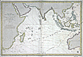 | Details | Depot de la Marine | 1862 |
| Fine French chart of the East Indies |
|
Depot de la Marine |
|
| 1862 |
| LOC:59 |
| $1,075.00 | Depot-de-la-Marine | Fine-French-chart-of-the-East-Indies | 1862 edition of a French nautical chart of the Indian Ocean and East Indies first published by the French Depot General de la Marine in 1837. French nautical charts of the Indian Ocean are scarce. No record of a sale of this chart is found in the AMPR.
<br></br>
This chart of the Indian Ocean to western Australia is based on exploration led by Daussy (Chief Hydrographer) and Wissocq. Engraved by Chassant. With contemporary manuscript ink annotations of a ship's daily course plotted east bound past the Cape of Good Hope and again west bound on the home trip. The positions extend far to the east, past the Philippine islands, another 4 days cruise past the neatline, and terminate at "Pelew" or the island of Palau.
<br></br>
Coverage includes a wide swath of ocean extending from Africa and Madagascar to Australia, Borneo, and Eastern China.
<br></br>
Published by order of the King. Seller's paste-on label at bottom right: "SAUVAT Libraire Rue Saint-Remy 3, a Bordeaux." |
| 59 | 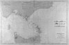 | Details | Depot de la Marine | 1864 |
| Detroit du Bass (Australie) |
|
Depot de la Marine |
|
| 1864 |
| LOC:59 |
| $1,400.00 | Depot-de-la-Marine | Detroit-du-Bass-(Australie) | Interesting antique nautical chart of South Australia, the Bass Straight and upper coast of Tasmania published by the Depot des Cartes et Plans de la Marine ( France ). Numerous lighthouses marked as red dots with yellow highlights and red circles indicating scope of lighthouse visibility. Includes Port Phillip and the city of Melbourne. Right center includes inset profile views. <BR> </BR>
With a black over-stamp for Cartes de la Marine Impériale. Debrie Libraire au Harve, Seul Depositaire. Price: Deux Francs. |
| 982 |  | Details | Depot de la Marine | 1867 |
| Plan of the Entrance to Valdivia Bay |
|
Depot de la Marine |
|
| 1867 |
| LOC:51 |
| $550.00 | Depot-de-la-Marine | Plan-of-the-Entrance-to-Valdivia-Bay | Antique French sea chart of the entrance to <b>Corral Bay</b> and the Valdivia estuary, situated to the southwest of the city of <b>Valdivia, Chile</b>. Clearly shows Mancera Island ("Ile Mansera") , Fort Niebla, Fort St. Carlos, Fort d"Amargos, and St Jean Bay. Two attractive elevation views of the coastline at the entrance to Valdivia River.
<br></br>
This edition of the old nautical chart was published in 1867 and contains changes made by French Naval officers Lartigue and Flury to an earlier survey by Ange René Armand, Baron de Mackau, Captain of the French 58-gun Frigate, the Clorinde (1822). The <b>Baron de Mackau</b> had been given command of the Clorinde which he sailed to the Pacific in order to conduct negotiations with the nascent states of Chile and Peru, in South America.
<br></br>
Inset plan of Corral Bay at bottom right: "Plan Particulier de l'Anse du Corral" with a small walled encampment, the "Chateau du Corral".
<br></br>
With an oval-shaped black ink overstamp from the seller in Harve, France. |
| 1262 | 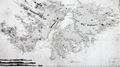 | Details | Depot de la Marine | 1868 |
| Antique sea chart of the Falkland Islands or Islas Malvinas |
|
Depot de la Marine |
|
| 1868 |
| LOC:0 |
| $0.00 | Depot-de-la-Marine | Antique-sea-chart-of-the-Falkland-Islands-or-Islas-Malvinas | SOLD<br></br>
Fine and scarce antique French nautical chart of the <b>Falkland Islands</b> after earlier surveys by Fitz-Roy, Robinson, and Sullivan of the British Admiralty. This large mid nineteenth-century navigation chart makes a very attractive presentation with its clean and bright appearance.
<br></br>
Originally published in 1850, this edition contains corrections to 1868. Contains inset elevation views of the Falklands coast. |
| 1322 | 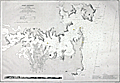 | Details | Depot de la Marine | 1869 |
| Rare Antique Nautical Chart of Port Jackson, Australia (Sydney) |
|
Depot de la Marine |
|
| 1869 |
| LOC:0 |
| $0.00 | Depot-de-la-Marine | Rare-Antique-Nautical-Chart-of-Port-Jackson--Australia-(Sydney) | SOLD <br></br>Rare and early large Gold-Rush era nautical chart of Port Jackson (Sydney, Australia) published by France's Depot de la Marine in 1861 (last corrections in 1869) based on the 1857 British Admiralty survey made under the command of Captain Denham. Large early nautical charts of Sydney / Port Jackson are very scarce. No record of a sale of this large chart (British or French) is found in the Antique Map Price Record. Includes a elevation view of Port Jackson as seen from offshore.
<br></br>
In his analysis of the accuracy of early charts of Sydney Harbor, Mulhearn noted:
<div class="indenttextblock">"The 1857 British Admiralty survey was carried out by Hutchison under the direction of a Captain Henry Mangles Denham F.R.S. who had been tasked with surveying parts of the south-west Pacific in HMS Herald. The chart of this survey, engraved in 1859, had the high soundings density one would expect with a modern hydrographic survey and it clearly marks a significant departure from earlier mapping efforts of Sydney Harbour. The area covered was from 1.5 miles (2.4 km) seawards of the harbour entrance west to Five Dock Bay. However sounding densities were relatively sparse west of Cockatoo Island, where a new dry dock, Fitzroy Dry Dock, was opened in late 1857. The survey and initial chart production took approximately two months." <a href="http://www.e-perimetron.org/Vol_9_2/Mulhearn.pdf " target="_blank">Online.</a></div>
<br></br>
The total population of Sydney and its suburbs in 1861 is estimated at 95,000 persons. |
| 5161 | 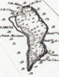 | Details | Depot de la Marine | 1870 |
| Antique French Chart of the Chagos Islands with Diego Garcia |
|
Depot de la Marine |
|
| 1870 |
| LOC:59 |
| $1,300.00 | Depot-de-la-Marine | Antique-French-Chart-of-the-Chagos-Islands-with-Diego-Garcia | Engraved antique nautical chart of the Chagos Island Archipelago, in the Indian Ocean, based on surveys of Moresby and Powell of the British East India Company. Published by the French Admiralty (Depot de la Marine) in 1841 with essential corrections in 1870.
<br></br>
The Chagos Island lie in the Indian Ocean about 300 miles south of the Maldive Islands. Diego Garcia, a United States military base, is located in the southeastern portion of the Chagos Archipelago.
<br></br>
Contains the circular anchor stamp of the Depot General de la Marine. With a black over-stamp, partially illegible but believed for "Cartes de la Marine Impériale. Debrie Libraire au Harve, Seul Depositaire."
<br></br>
Price: two Francs. Engraved by Chassant. Chart number 943. |
| 910 | 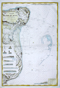 | Details | Depot de la Marine | 1871 |
| Antique nautical chart of coastal Kent, England from Dover to Margate |
|
Depot de la Marine |
|
| 1871 |
| LOC:64 |
| $875.00 | Depot-de-la-Marine | Antique-nautical-chart-of-coastal-Kent--England-from-Dover-to-Margate | Very attractive 1871 edition of an antique nautical chart of the coast of <b>Kent, England</b> including the towns of Dover, Deal, Sandwich, Ramsgate, Broadstairs, and Margate; originally issued in 1866.
Carefully hand-colored, this fine French Sea chart is a fabulous example of the value and appeal that coloring can add to a chart. This chart would make a fine gift for any sailor or fisherman who travels those waters.
<br></br>
Numerous attractive inset elevation views of the coast and drawings of navigational aids. These inset views include the Balise du Godwin Safety (a balise was an elevated signal fire); three lighthouses: "Feu de North Foreland", "Feu de Ramsgate", "Feu Superieur de South Foreland"; and seven extremely decorative profile views of the coast with homes, mills, churches and towers as they existed in 1866. These fine coastal elevation views include: Pugin's Tower; Broadstairs North Cliff with the Ramsgate jetty below; the Deal wharf with Old Parker's Cap in the background; a single view with Kingsdown Church in alignment with Ripple Mill and Walmer Castle aligned to the Upper Deal Mill; Old Stairs Bay; the Admiral's wharf with Shakespeare Cliff; and finally at the upper right, a long profile that includes Saint Lawrence Church, Ramsgate Church, the North Down monument and Redding Street balise.
<br></br>
Includes the dangerous North Goodwin Sands offshore the coast protected by these lightships: "Feu FixeSouth Sand Head", "Feu Floyttant de la Pt. N. du Goodwin" and "Gulf Stream Feu tournant de 20 s and 20 s"
<br></br>
Published by France's Depot des Cartes et Plans de la Marine with corrections in 1871 based on an earlier work from 1866 by the British Admiralty. Number 2410. Contains a blue ink over-stamp from the seller "Au Semaphore" in Havre. |
| 911 | 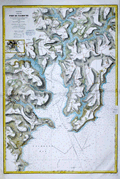 | Details | Depot de la Marine | 1871 |
| Antique nautical chart of the Bay and Port of Falmouth, England |
|
Depot de la Marine |
|
| 1871 |
| LOC:64 |
| $825.00 | Depot-de-la-Marine | Antique-nautical-chart-of-the-Bay-and-Port-of-Falmouth--England | Very attractive 1870 antique nautical chart of the <b>Port of Falmouth, England</b> on the south coast of Cornwall. The chart includes the towns of Penryn, Flushing, and Falmouth with an 3" x 4" inset map of Truro at left. Carefully hand-colored after issue, this fine French Sea chart is a fabulous example of the value and appeal that coloring can add to a chart. The blue wash coloring along the coastal margins and light brown highlights of the carefully hachured topographic detail heighten the allure of this decorative navigational lithograph. This chart would make a fine gift for any sailor or boat-man who travels the waters near Falmouth Bay.
<br></br>
Filled with the expected hundreds of depth soundings, isobaths (countour lines of equal depth below the surface), navigational hazards and aids to navigation. Also includes copious detail of the creeks, roads, villages, and topography in the surrounding area. A sample of those details include: <b>Pendennis Castle</b>; St. Mawes Harbor; Swan Pool; St. Gluvias Church; Beacon Hill; Conreeth Moor; the Truro branch of the West Cornwall Railway; St. Michael Penkevit Church; Saint Anthony Church; and Lamorran Church
<br></br>
Contains a blue ink over-stamp from the seller "Au Semaphore" in Havre, France.
<br></br>
Originally issued by France's Depot des Cartes et Plans de la Marine in 1867, this edition contains corrections up to 1870. Chart is based on an earlier work from 1853 by the British Admiralty. Number 2445. |
| 345 |  | Details | Depot de la Marine | 1872 |
| Carte Particuliere de la Cote Sud-Ouest d'Amerique |
|
Depot de la Marine |
|
| 1872 |
| LOC:67 |
| $355.00 | Depot-de-la-Marine | Carte-Particuliere-de-la-Cote-Sud-Ouest-d-Amerique | Large mid-nineteenth century antique nautical chart from the French Depot de la Marine. This antique chart is made more interesting by the display of extensive topographical relief details of the coastal margins. Detailed coverage of the Southwest coast of Patagonia (Chile) from the Western approach to the Strait of Magellan (near the Evangelistas group of islands) north to the Gulf of Penas. An inside route is shown that would have permitted 19th century navigators to bypass at least some of the lower Pacific. Features include Mont Burney, insets of Hevre de l"isle and Anse Colombine; numerous islands, archipelagos, and straits. <BR> </BR>
Corrected version from 1872 of a chart first published in 1851. No. 1307. With circular stamp of Depot General de la Marine. |
| 896 | 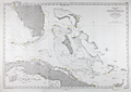 | Details | Depot de la Marine | 1873 |
| Antique French Chart of the Straits of Florida and Bahamas |
|
Depot de la Marine |
|
| 1873 |
| LOC:1111 |
| $900.00 | Depot-de-la-Marine | Antique-French-Chart-of-the-Straits-of-Florida-and-Bahamas | Attractive antique French navigation chart covers the <b>Strait of Florida</b>, Grand Bahama Bank, Little Bahama Bank, and much of Cuba. Originally released in 1865 this edition was printed with updates in 1873 by France's Depot de la Marine. Includes the Florida Keys, the Tortugas, Great Abaco Island, Grand Bahama Island, Andros Island, and the Bahamian island chain as far south as Great Inagua Island. Named habitations include Tampa, Florida, and Havana, Cuba.
<br></br>
Perhaps the most significant feature of the map is the lack of settlements along Florida's east coast. Hydrographic features on the lower east coast include the Indian River, Jupiter Inlet, Biscayne Bay, and Hillsboro Inlet ("Entre de Hillsboro") but the sole settlement is <b>Fort Dallas</b>, established on Key Biscayne by the U.S. Navy in 1836 to prevent trade between the indigenous Seminole Indians and traders from Cuba and the West Indies.
<br></br> Chart is a lithograph, based on U.S. and Spanish precursor charts, produced in 1873 by France's Depot de Cartes et Plans de la Marine, their official hydrographic agency. |
| 1464 | 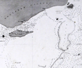 | Details | Depot de la Marine | 1874 |
| Detroit de Torres. Second sheet. |
|
Depot de la Marine |
|
| 1874 |
| LOC:59 |
| $200.00 | Depot-de-la-Marine | Detroit-de-Torres---Second-sheet- | Fine antique small-scale nautical chart (Sheet 2 of 3) of northern Torres Strait, the body of water separating the continent of Australia (Nouvelle Hollande) from New Guinea. Last corrections in 1874. One of 4 charts of the Torres Strait area produced by the Depot de la Marine, this being the second detail sheet encompassing the north end of the strait near New Guinea. |
| 1465 | 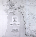 | Details | Depot de la Marine | 1875 |
| Detroit de Torres. Third sheet with Raine Island |
|
Depot de la Marine |
|
| 1875 |
| LOC:59 |
| $600.00 | Depot-de-la-Marine | Detroit-de-Torres---Third-sheet-with-Raine-Island | Fine antique small-scale nautical chart (Sheet 3 of 3) of southern Torres Strait, the body of water separating the continent of Australia (Nouvelle Hollande) from New Guinea. Last corrections in 1874. One of 4 charts of the Torres Strait area produced by the Depot de la Marine, this being the third detail sheet encompassing the south end of the strait and the tip of the Cape York Peninsula in north Australia.
<br></br>
<b>Inset drawings of Raine Island and the tower on Raine Island</b>, on the outer edges of the Great Barrier Reef, about 120 km east-northeast of Cape Grenville, Cape York Peninsula. Raine Island, a small vegetated coral cay, is the site of the oldest European structure in tropical Australia, a stone beacon built in 1844. An important environmental icon, Raine island got its name from Captain Thomas Raine (1793-1860), the English mariner who discovered it. |
| 1466 | 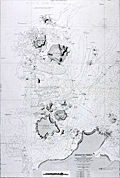 | Details | Depot de la Marine | 1875 |
| Detroit de Torres First sheet with York Island |
|
Depot de la Marine |
|
| 1875 |
| LOC:59 |
| $600.00 | Depot-de-la-Marine | Detroit-de-Torres-First-sheet-with-York-Island | Fine antique small-scale nautical chart (Sheet 1 of 3) of southern Torres Strait, the body of water separating the continent of Australia (Nouvelle Hollande) from New Guinea. First published in 1860 with last corrections made in 1875.
<br></br>
One of 4 charts of the Torres Strait area produced by the Depot de la Marine, this being the first detail sheet encompassing the Cape York Peninsula, York Island "Ile du Prince de Galles", Eborac Island, and numerous other cays and islands in the Torres Strait Archipelago. |
| 1330 | 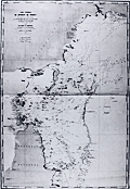 | Details | Depot de la Marine | 1875 |
| Antique Chart of Cape York Peninsula, Australia and Torres Strait |
|
Depot de la Marine |
|
| 1875 |
| LOC:59 |
| $800.00 | Depot-de-la-Marine | Antique-Chart-of-Cape-York-Peninsula--Australia-and-Torres-Strait | Fine antique small-scale nautical chart of the Torres Strait, the body of water and passage separating the continent of Australia (Nouvelle Hollande) from New Guinea. Last corrections in 1875. Prominently shows the Cape York Peninsula, the northern-most portion of the Australian state of Queensland, surrounded by the Sea of Carpenteria to the west and the Coral Sea to the east. New Guinea lies to the north. (One of 4 charts of the Torres Strait area, this being the general chart of the entire area).
<br></br>
Published by the French Depot des Cartes and Plans de la Marine in 1860, this edition with corrections to 1875. Number 1861. |
| 950 | 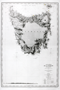 | Details | Depot de la Marine | 1876 |
| Antique Nautical Chart of Tasmania, Australia |
|
Depot de la Marine |
|
| 1876 |
| LOC:59 |
| $3,275.00 | Depot-de-la-Marine | Antique-Nautical-Chart-of-Tasmania--Australia | A bold, large, antique French hydrographic chart of the island of <b>Tasmania</b>, a part of the Commonwealth of Australia, after an English chart by F.J. Evans, master of the British Royal Navy (1860). Beautifully engraved, this old nautical chart on laid paper was first published by France's Depot de la Marine in 1867 and last updated with corrections in 1876. Coverage to the north includes portions of the Bass Strait and Banks Strait; Cape Barren Island and Clarke Island; and the Hunter Islands. Key features noted in Tasmania are largely within a few hundred miles of the coast; the interior is devoid of detail. Includes <b>Port Dalrymple</b>, George Town, Port Maquarie, Port Davey, Hobart ("Hobarttown"), the Derwent River and Fleurieu Bay.
<br></br>
Near bottom of the chart is found a elevation view of the southern approaches to the island extending from Maatsuyker Island to Cape Tasman. Elevation detail is shown by meticulous hachuring and shading and includes numeous peaks on that mountainous island. Mount Wellington, Cradle Mountain, Frenchman's Cap, Mount Victoria, and Eldon Peak are a few of the numerous peaks noted even though many of the highest peaks on the island had yet to be discovered as late as the mid 19th century.
<br></br>
Tasmania was first discovered in 1642 by an expedition led by Dutch explorer Abel Tasman aboard ships of the Dutch East India Company. During the first part of the 19th century the island served as the main penal colony for Australia and as many as 75,000 convicts were transported there. The island was originally known as <b>Van Diemen's Land</b>, a practice that continued until 1856 when it was renamed Tasmania . Number 2536.
<br></br> |
| 871 | 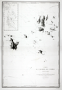 | Details | Depot de la Marine | 1878 |
| Chart of the Anambas Archipelago of Indonesia in the South China Sea |
|
Depot de la Marine |
|
| 1878 |
| LOC:0 |
| $0.00 | Depot-de-la-Marine | Chart-of-the-Anambas-Archipelago-of-Indonesia-in-the-South-China-Sea | SOLD
<br></br>
Scarce chart of the Anambas Islands of Indonesia found in the South China Sea between the Malaysian mainland to the west and the island of Borneo to the east. This antique French nautical chart published in 1878 is based on the exploration conducted aboard the French Frigate 'la Favorite' during March and April 1831 by Captain Cyrille Pierre Théodore Laplace. Major islands shown on the chart include Pulau Jemaja, Pulau Telaga, Pulau Siantan, Pulau Siantan, Pulau Bajau, Pulau Mubur, and Pulau Matak.
<br></br>
Contains a detailed inset at upper right of the tracks of earlier exploration in 1825 by Du Camper aboard the l'Esperance and Bougainville on la Thetis. |
| 762 | 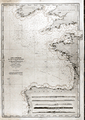 | Details | Depot de la Marine | 1878 |
| Antique French Nautical Chart of Spain, Ireland and England |
|
Depot de la Marine |
|
| 1878 |
| LOC:0 |
| $0.00 | Depot-de-la-Marine | Antique-French-Nautical-Chart-of-Spain--Ireland-and-England | SOLD
<br></br>
Antique navigation chart covering the approaches along the south and west coasts of Spain, Cornwall England and Southern Ireland. Includes the Gulf of Gascogne; the English Channel northeast to Chichester and le Harve; and the Irish Sea. This large chart is unusual in that it shows all the numerous lighthouses along those coastlines and through red overprinting shows for each light the expected range over which that light should be visible from sea. Lighthouses are shown as red dots with yellow highlights.
<br></br>
Inset at bottom shows five profile coastal views. Chart is the edition of 1867, first published in 1828 and 1829. This edition was updated last in 1878. Number 447. Published by France's Depot de la Marine. |
| 764 |  | Details | Depot de la Marine | 1878 |
| Antique Nautical Chart of the North Sea and British Isles |
|
Depot de la Marine |
|
| 1878 |
| LOC:0 |
| $250.00 | Depot-de-la-Marine | Antique-Nautical-Chart-of-the-North-Sea-and-British-Isles | Large French antique nautical chart of the North Sea and the British Isles published in 1867 and updated with corrections to 1878. Detailed coverage includes the coasts of France, Belgium, Holland, Denmark, and Norway from Bordeaux, France at the south all the way to Averoy, Norway at the north. Includes the Faroe, Orkney, and Shetland islands, the Skaggerak, English Channel ( la Manche ) , Irish Sea, and North Sea.
<br></br>
Several hundred coastal lighthouses and lighted navigational aids are highlighted with a red dot and a yellow highlight. Three pasted on paper corrections at bottom when issued by the Depot de la Marine. Number 2367. |
| 1277 | 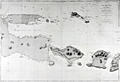 | Details | Depot de la Marine | 1880 |
| Antique chart of East Java and the Madura Strait |
|
Depot de la Marine |
|
| 1880 |
| LOC:0 |
| $450.00 | Depot-de-la-Marine | Antique-chart-of-East-Java-and-the-Madura-Strait | Antique French sea chart of east Java, Indonesia with the Strait of Madura, Lombok, <b>Bali</b> (Baly), and the <b>Kangean Archipelago</B>. A very attractive, large and clean antique nautical chart with finely-engraved detailed togography.
<br></br>
This chart was first issued by France's Depot de la Marine in 1862 and re-issued here with corrections in 1880. After an earler chart by Lt. Swann of the Royal Maraine Hollandaise. |
| 877 | 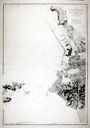 | Details | Depot de la Marine | 1881 |
| Antique Port Plan of Marseille, France in Provence |
|
Depot de la Marine |
|
| 1881 |
| LOC:58 |
| $875.00 | Depot-de-la-Marine | Antique-Port-Plan-of-Marseille--France-in-Provence | Old French large-scale chart of the port and harbor of Marseilles, France in the Provence region. The geographical extent of this antique chart extends from Cap Janet trending southward past the Iles d'Endoume ending at the beach area of Plage de Mont-Redon. Coverage includes the small island of Chateau d'If and eastern portions of Ile Ratonneau and Iles du Frioul .
<br></br>
Key features that are noted by name include: Chateau Talabot, tour St. Michel, the Nouvelle Cathedrale, Anse des Catalans, les Accoules, Hotel des Villes, and the Bassin de Carenage. Shows two lighthouses marking the entrance to the old harbor which is protected by Fort St. Jean and Fort St. Nicolas.
<br></br>
Published by France's Official Hydrographical Agency the <b> Depot des Cartes et Plans de la Marine</b>. Date of last correction: 1881. |
| 1361 | 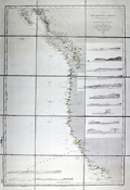 | Details | Depot de la Marine | 1886 |
| Antique chart of the United States West Coast |
|
Depot de la Marine |
|
| 1886 |
| LOC:2001 |
| $550.00 | Depot-de-la-Marine | Antique-chart-of-the-United-States-West-Coast | Large folding nautical chart of the West Coast of the United States from past San Diego, California in the South to Queen Charlotte Sound and Moresby Island in British Columbia, Canada. Published by France's Depot de la Marine in 1862 but this edition with essential corrections dates to 1886.
<br></br>
With owners overstamps from the Library of Canadian Energy, Mines, and Resources Department in 1969 and 1976. Chart Number 1979. |
| 873 | 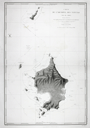 | Details | Depot de la Marine | 1888 |
| Chart of the Natuna Archipelago of Indonesia in the South China Sea |
|
Depot de la Marine |
|
| 1888 |
| LOC:0 |
| $0.00 | Depot-de-la-Marine | Chart-of-the-Natuna-Archipelago-of-Indonesia-in-the-South-China-Sea | SOLD<BR></BR>
Large antique French sea chart of the Natuna Island Archipelago located in the South China Sea about 300 miles northeast of Singapore. The Natuna Islands, off the northwest coast of Borneo are technically part of Indonesia although China has included them inside its nine-dash line, an area of the South China Sea within which it claims sovereignty to all the islands, atolls, and reefs. The claims of China are disputed by Indonesia, Vietnam, the Philippines and other countries.
<br></br>
With the route of the French corvette La Favorite during their exploration of the area in 1831. This edition of the chart dates to August 1888. Published by the Depot de la Marine, France's official Hydrographic Agency. |
| 288 |  | Details | Depot de la Marine | 1895 |
| Cote est D'Irlande de la Baie de Dublin de la Baie de Belfast |
|
Depot de la Marine |
|
| 1895 |
| LOC:0 |
| $275.00 | Depot-de-la-Marine | Cote-est-D-Irlande-de-la-Baie-de-Dublin-de-la-Baie-de-Belfast | Interesting and uncommon folding 1895 edition (bottom of chart) of an antique nautical chart first printed in 1875. This intact linen-backed large folding chart of the Irish sea was published by the French Admiralty (Depot des Cartes et Plans de la Marine). Covers a wide area of Ireland and western portions of Britain including Belfast and Dublin , Isle of Man, and Holyhead Island. Lighthouses highlighted in yellow.<BR> </BR>
The antique chart folds to 5" x 9 1/2". Folds into 3 sections horizontally and 8 sections vertically. With a printed seller's sticker on front: " Maison Andriveau Goujon. Henry Barrere, Editeur-Geographe. 21 Rue du Bac, Paris". On the sticker below the seller's attribution is a script annotation of the chart title and a date of 1906.<BR> </BR>
Insets of the Port of Killough, Port of Ardglass, and a small view of the entrance to the Bay of Dundalk. Platemark is apparent but the chart is probably lithographic due to late 19th century provenance. Number 3460. Price: two francs. |
| 1362 | 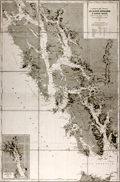 | Details | Depot de la Marine | 1902 |
| Antique nautical chart of southern Alaska, Prince of Wales Island, Juneau |
|
Depot de la Marine |
|
| 1902 |
| LOC:2001 |
| $1,200.00 | Depot-de-la-Marine | Antique-nautical-chart-of-southern-Alaska--Prince-of-Wales-Island--Juneau | Fine nineteeth-century folding Gold-Rush era nautical chart of southwest Alaska from Graham Island/Dixon Entrance past Prince of Wales Island, and terminating with Glacier Bay. Large, separately issued French chart of the Alaska Panhandle and the inside passage. Includes part of the route used by modern cruise ships visiting Juneau or Haines or Skagway, Alaska. Inset of "Extremite nord du Canal Lynn".
<br></br>
Published first in 1893, this edition contains corrections to 1902. Early charts of Alaska are scarce. No copies of this antique chart are listed in OCLC/WorldCat or in the Antique Map Price Record.
<br></br>
Some of the many named features on this fine chart include Admiralty Island, Cross Sound, Baranoff Island, Dall Island, and Wrangell Island, Chatham Canal, Port Protection (of TV fame), Haines, and the Skagway River. Numerous mountains with elevation details as well as many glaciers are identified and named.
<br></br>
With owners overstamps from the Library of Canadian Energy, Mines, and Resources Department in 1969 and 1976. Number 4553. |
| 756 | 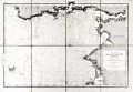 | Details | Depot de la Marine | 1907 |
| Antique nautical chart of Brittany Coast near the Vilaine River |
|
Depot de la Marine |
|
| 1907 |
| LOC:0 |
| $425.00 | Depot-de-la-Marine | Antique-nautical-chart-of-Brittany-Coast-near-the-Vilaine-River | Antique chart of the west coast of France from the Anse de Cornaud and Pointe du Grand Mont southward to le Croisic. First published in 1826, this chart of Brittany includes part of the Department of Morbihan, and the mouths of the Penerf and Vilaine rivers. The chart is updated as of 1907. Settlements and habitations covered include Cornaud, Saint-Gildas-de-Rhuys, Chateau de Suscino (en ruins), Damgan, Port de Billiers, Penestin (Pennetin), Mesquer, Piriac-sur-Mer, la Turballe, Guerande, Clie, and Saille. The chart extends westward to include the Ile d'Hoedic and many surrounding smaller islets of the greater and lesser Cardinaux Islands.
<br></br>
Very extensive and minute detail of the shoreline and near shore areas with elevation denoted by fine hachuring. Hundreds of individual structures are placed accurately. Thousands of soundings with isobath contour lines and navigational hazards would have aided the coastal navigator in the area.
<br></br>
This is a early 20th century linen-mounted folding chart, an updated edition of a chart first published by France's Depot de la Marine in 1826. This sea chart is based on the original surveys conducted in 1820 and 1821 under the supervision of Charles-François Beautemps-Beaupré (1766-1854), considered to be the father of modern French hydrography. Linen verso is printed via letterpress with "De La Pointe du Grand-Mont AU CROISIC. Entrée de la Vilaine." |
| 758 | 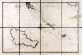 | Details | Depot de la Marine | 1908 |
| Antique nautical chart of Quiberon Bay with islands of Belle-Ile, Hoedic, and Houat |
|
Depot de la Marine |
|
| 1908 |
| LOC:66 |
| $425.00 | Depot-de-la-Marine | Antique-nautical-chart-of-Quiberon-Bay-with-islands-of-Belle-Ile--Hoedic--and-Houat | Antique lithographed chart of waters offshore of the west coast of France from southwest of the village of Saint Gildas and the Pointe du Grand-Mont. First published in 1826, this chart near the Brittany coast in western France includes the peninsula of Presqu'ile Quiberon and is the edition of January 1903 published with the latest updates in 1908.
<br></br>
Very extensive and minute detail of the shorelines and near shore areas with elevation denoted by fine hachuring. Thousands of soundings with isobath contour lines and navigational hazards would have aided the coastal navigator in the area. At the far right a particularly dangerous area for navigators, the "Plateau de la Recherche" is highlighted in brown
<br></br>
This is a early 20th century linen-mounted folding chart, an updated edition of a chart first published by France's Depot de la Marine in 1827. This lithographed nautical chart is based on the original surveys conducted during 1820 and 1821 under supervision of Charles-François Beautemps-Beaupré (1766-1854), considered to be the father of modern French hydrography. Beautemps-Beaupre was one of the earliest hydrographers to use isobaths to represent water depth.
<br></br>
Linen verso is printed via letterpress with "BELLE-ILE Entrée de la Baie de Quiberon. Iles Houat et Haedik". Number 135. |
| 771 | 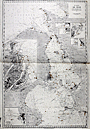 | Details | Depot de la Marine | 1922 |
| Chart of the Oresund from Baltic Sea to Kattegat |
|
Depot de la Marine |
|
| 1922 |
| LOC:0 |
| $0.00 | Depot-de-la-Marine | Chart-of-the-Oresund-from-Baltic-Sea-to-Kattegat | SOLD
<br></br>
Large 90+ year old nautical chart of the Oresund or sound connecting the Baltic Sea to the Kattegat and separating Sweden from Denmark. This plate is a 1922 edition of a French navigational chart first published in 1892. Large inset at left of the Port de Copenhague ( Copenhagen ) Denmark; small insets of Landskrona, Port d'Hoganas, Port de Raa, Port d'Elseneur, Port de Skanor, and Port d'Helsingborg.
<br></br>
Published by the French Naval Hydrographic Service which was the successor to the Dépôt des cartes et plans de la Marine, founded in 1720. In 1971 it became known as the Naval Hydrographic and Oceanographic Service (service hydrographique et océanographique de la marine or SHOM).
<br></br>
Aids to navigation are highlighted in orange. Lower left corner contains two stamps: One inked stamp from the Service Hydrographique and the other a purple sticker from the map seller: "V. Weizsaeker, Opticien de la Marine. 13 Rue du Quai, Dunkerque" |