DESCRIPTION: SOLD
A recently uncovered landmark in early American conservation history, this 1882 map is the earliest known unified depiction of the Middlesex Fells and a nationally significant artifact from the birth of forest and open-space preservation in the United States. Created in the same year that Massachusetts enacted the first public-domain conservation law, the map captures the moment when advocates began to view the Fells as a single landscape worthy of protection. It also appears to be the earliest known use of the then cutting-edge blueprinting process for a conservation map, underscoring its pioneering role in both environmental advocacy and cartographic technology.
Compiled in November 1882—three years after Sylvester Baxter introduced the name “Middlesex Fells,” two years after Elizur Wright and Wilson Flagg founded the Middlesex Fells Association, and only six months after passage of the Public Domain Act (Chapter 255, Acts of 1882)—the map’s title closely mirrors the statutory language authorizing preservation of forests and water supply. Fuller & Whitney describe land “designed to be set apart as a Public Domain for the preservation and production of Forest Trees and the Water Supply of many Cities & Towns,” echoing the Act almost verbatim. Issued in immediate response to this new legal authority, the 1882 sheet stands as a deliberate visual expression of the law’s intent and a foundational document in America’s earliest forest-preservation movement.
Manuscript master surveyor's ink trace map on tracing cloth. MS pencil index notation bottom right: “973 – 974.
Possibly unpublished. The map predates the Appalachian Mountain Club map by four years and the Topographical Map of Middlesex Fells Reservation by thirteen.
Fuller and Whitney
Back Bay Engineers (1872- 1888)
From 1872 to 1888, Fuller & Whitney Civil Engineers thrived as a partnership between J. Franklin Fuller and William H. Whitney. In 1888, Whitney assumed sole proprietorship, boldly renaming the firm "William H. Whitney" to reflect his visionary leadership.
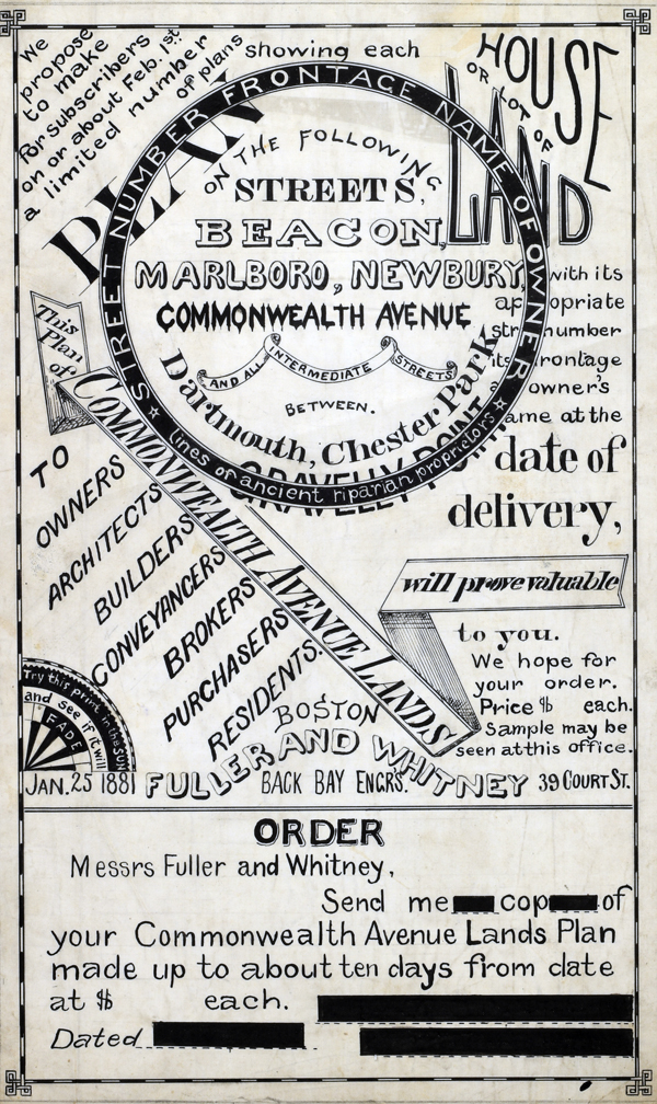 1881 MS Trace Fuller and Whitney Ad and Order Form 1881 MS Trace Fuller and Whitney Ad and Order Form
(not included)
In his autobiography Whitney refers to his work with the latest cutting-edge reprographic technology- blueprinting: “In September 1881 I received a bronze medal at the Massachusetts Charitable Mechanic Association Exhibit for sun or blue prints. I developed a process from the French and used it in illustrating the growth of Back Bay lands. I issued to subscribers monthly schedules and maps showing the changes of ownership, increase in value, improvement by filling and public works.” (The New England Historical and Genealogical Register. Vol 64, January 1910. Number 253. p. lix)
PUBLICATION DATE: 1882
GEOGRAPHIC AREA: United States
BODY OF WATER: Spot Pond
CONDITION: Good.
Clean with no holes or tears. Light stains.
COLORING: N/A
ENGRAVER:
SIZE: 15
" x
16 "
ITEM PHYSICAL LOCATION:
PRICE: $
ADD TO CART

|