DESCRIPTION: This fine single leaf with printing on two sides is a rare early example of the adoption and adaptation of a new printing technology (blueprinting). William Whitney's use of blueprinting enabled his firm to publish works contemporaneously with the ongoing land making in Boston's Back Bay, thus reducing cycle time and gaining greater control over his firm's publication of cadastral data. Using blueprints Fuller and Whitney could research, design, create artwork, and print their own works.
Original blueprint of Boylston Street in Boston, Massachusetts east of Massachusetts Avenue (Ex. West Chester Park) to Dartmouth Street. During the Back Bay Land making Project of the mid-19th century fill averaging 20 feet in depth was added to 450 acres of mud flats that lay to the west of Boston's Public Garden. Proceeding from east to west, by 1870 the land was filled as far as Exeter Street and land making was completed to West Chester Park by 1882.
Blueprint on the recto consist of a plan of Boylston Street from Fuller and Whitney's 1882 issue of "Schedule of Sales Commonwealth Avenue Lands, 1882. With Plan." On the verso a table of data as above. No. 7.
Fuller and Whitney
Back Bay Engineers (1872- 1888)
From 1872 to 1888, Fuller & Whitney Civil Engineers thrived as a partnership between J. Franklin Fuller and William H. Whitney. In 1888, Whitney assumed sole proprietorship, boldly renaming the firm "William H. Whitney" to reflect his visionary leadership.
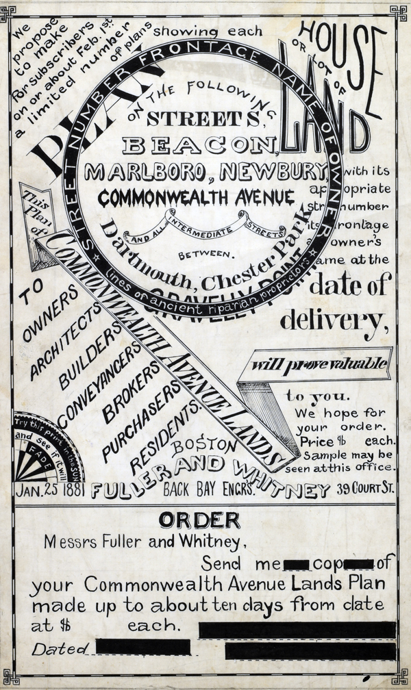 1881 MS Trace Fuller and Whitney Ad and Order Form 1881 MS Trace Fuller and Whitney Ad and Order Form
(not included)
In his autobiography Whitney refers to his work with the latest cutting-edge reprographic technology- blueprinting: “In September 1881 I received a bronze medal at the Massachusetts Charitable Mechanic Association Exhibit for sun or blue prints. I developed a process from the French and used it in illustrating the growth of Back Bay lands. I issued to subscribers monthly schedules and maps showing the changes of ownership, increase in value, improvement by filling and public works.” (The New England Historical and Genealogical Register. Vol 64, January 1910. Number 253. p. lix)
PUBLICATION DATE: 1882
GEOGRAPHIC AREA: United States
BODY OF WATER: N/A
CONDITION: Very good.
No condition issues. Clean. Ample margins.
COLORING: N/A
ENGRAVER:
SIZE: 13
" x
15 "
ITEM PHYSICAL LOCATION: 0
PRICE: $650
ADD TO CART

|