DESCRIPTION: SOLD
Fine pictorial map of Baxter State Park, Maine by Augustus D. Phillips & Son - Northeast Harbor Maine, dated within to 1965 and presumed first edition. As a dedication below the title Phillips wrote:
For the heritage of this Mighty, Mountained, Wilderness Park the People of this State of Maine and their Children's Children will Forever be Grateful to the Honorable Percival P. Baxter, Governor of Maine ~ 1921 - 1924 ~ Who Conceived it and Gave the 201,018 Acres of Land for it."
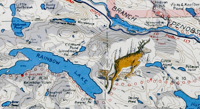 Baxter State Park map detail.. Baxter State Park map detail..
Scarce, only 3 holdings are recorded in WorldCat but the map was apparently issued three times, in 1965, 1970, and 1972.
Augustus "Gus" Dewey Phillips
(1898 - 1975)
Augustus' brother, Luther started the map business and Augustus stepped in to take over when Luther passed away in 1960.
Luther Phillips, who was known for his talent in pictorial cartography and photography, began his mapmaking and postcard businesses in the early 1900s. He created maps and postcards featuring scenic views of Maine, including images of lighthouses, lakes, mountains, and beaches. His maps were detailed and included information about roads, landmarks, and other important features of the state.
After Luther's death in 1960, his younger brother, Augustus "Gus" Phillips, took over the businesses and continued to produce maps and postcards. Gus had learned all aspects of the businesses from Luther and had a passion for landscape painting, which influenced the evolution of his own map style. Gus expanded the Phillips Maps of Maine and updated several of Luther's maps, as well as creating new ones. He also continued to travel the state photographing views for postcards and other publications.
The Phillips Collection at the Penobscott Maritime Museum consists of more than 30 original maps of regions of Maine and some 600 original postcards created by brothers, Augustus "Gus" and Luther Phillips and were the basis of a business, State O’Maine Post Cards and The Phillips Maps of Maine.
PUBLICATION DATE: 1965
GEOGRAPHIC AREA: United States
BODY OF WATER: Numerous.
CONDITION: Good.
Small tear at lower right repaired archivally from the verso,
COLORING:
ENGRAVER:
SIZE: 15
" x
23 "
ITEM PHYSICAL LOCATION: 53
PRICE: $
ADD TO CART

|