| | Thumbnail | | Creator | Date | Title / Author / Date / Location | Price | | | Description |
| 8000 | 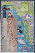 | Details | Exploration Cruise Lines | 1985 |
| Cool pictorial cruise poster of Alaska |
|
Exploration Cruise Lines |
|
| 1985 |
| LOC:130 |
| $365.00 | Exploration-Cruise-Lines | Cool-pictorial-cruise-poster-of-Alaska | Rare possibly unrecorded large format travel poster for Exploration Cruise Lines ca. 1985.
<br><br>
This promotional poster for Exploration Cruise Lines presents a stylized map of Alaska and the Pacific Northwest, built around the slogan “Nobody Gets You Closer to Alaska.” The map combines illustrated geographic features—such as Glacier Bay, Frederick Sound, the Gulf of Alaska, Yakutat Bay, and the Inside Passage—with small icons marking wildlife including bears, eagles, whales, seals, and mountain goats. Port calls and route segments are clearly labeled: Sitka, Juneau, Ketchikan, Wrangell, Petersburg, Seward, Prince Rupert, and other locations appear along color-coded itineraries for the Great Rivers Explorer and Pacific-Northwest Explorer. Insets summarize key regions (“Outside, the Inside Passage,” “Yakutat Bay,” “The Inside Passage and Beyond,” and “Alaska for the Independent Traveler”), highlighting landmarks such as Columbia Glacier, Hubbard Glacier, the Kenai Peninsula, Denali National Park, and the Misty Fiords National Monument.
<br><br>
The lower section features a large depiction of an Exploration Cruise Lines vessel entering Alaskan waters, together with the company’s name and sunburst logo. Text blocks emphasize the line’s focus on remote scenery, wildlife viewing, and smaller-ship access to narrow channels and glacial bays. A sidebar provides a simplified Inside Passage index and distances between ports, reinforcing the company’s claim of operating close-in routes not accessible to larger cruise ships. As a surviving piece of cruise-line ephemera from a short-lived 1980s operator, the poster documents how Exploration Cruise Lines marketed its Alaskan itineraries and presents a period design that blends infographic mapping with illustrative regional imagery. |
| 5209 | 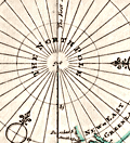 | Details | Moll, Herman | 1744 |
| Map of the North Pole by Herman Moll 1744 |
|
Moll, Herman |
|
| 1744 |
| LOC:13 |
| $325.00 | Moll--Herman | Map-of-the-North-Pole-by-Herman-Moll-1744 | Fine original antique 18th-century polar map of the North Pole by Herman Moll. This scarce map is annotated with observations and facts regarding early exploration of the north polar region. Perhaps this is an unrecorded fifth state of the map as the "Vol 1. p. 714" found at upper left in the fourth state has been largely effaced and only a faint hint of the graved lines remain visible. The number " 2 " at upper right is clearly visible.
<br></br>
This striking polar projection shows Iceland, Greenland, Spitsbergen, Nova Zembla, portions of North America and Northern Europe. Text blocks at right and left detail the sun's movement at high latitudes and the explorations of the polar region by Frobisher, Davis and others
<br></br>
Published in London in "Thomas Salmon's Modern History: or the Present State of All Nations." Printed for Tho: Bowles next the Chapter House in St. Pauls Church Yard, & John Bowles at the Black Horse in Cornhill, London. |
| 4825 | 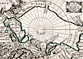 | Details | Picart, Jean | 1657 |
| Scarce original engraving of the North Polar Region |
|
Picart, Jean |
|
| 1657 |
| LOC:13 |
| $480.00 | Picart--Jean | Scarce-original-engraving-of-the-North-Polar-Region | Picart's map of the North Pole (second state) based on Jansson's Septentrionalium Terrarum Descript from the Atlas Minor. An early map of the Arctic region seldom found in this fine condition. |
| 1427 | 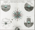 | Details | Brion, Louis, de la Tour | 1766 |
| 18th-century astronomical engraving of spherical orientations |
|
Brion, Louis, de la Tour |
|
| 1766 |
| LOC:9 |
| $250.00 | Brion--Louis--de-la-Tour | 18th-century-astronomical-engraving--of-spherical-orientations | Attractive antique engraving ca. 1766 related to astronomy and in particular to the viewer's perception of various two-dimensional orientations of the earth including the oblique and parallel projections.
<br></br>
Brion's diagrams are organized around a large, attractive, and very decorative compass rose. Additionally, a large and decorative border surrounds the entire print. Two plates were used in the production of this print, one plate for the border, evidenced by the nesting platemarks plainly visible to the viewer. Number 4.
<br></br>
From the "Atlas général civil et ecclésiastique" by Louis Brion de la Tour, Ingénieur-géographe du Roi. |
| 1413 | 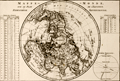 | Details | Bonne, Rigobert | 1787 |
| Antique Northern Polar Projection or Hemisphere Septentrional |
|
Bonne, Rigobert |
|
| 1787 |
| LOC:9 |
| $180.00 | Bonne--Rigobert | Antique-Northern-Polar-Projection-or-Hemisphere-Septentrional | Attractive North polar projection covering the Northern Hemisphere or "Hemisphere Septentrional" from the North Pole to the Equator. Early French copper-plate engraved map produced by Rigobert Bonne and crisply and finely engraved by Andre' to include mountain ranges and numerous place names. Surrounded by two tables of climatological data and a view of the "Sphere Parallele." Published in Paris in 1787. Plate 22.
<br></br>
Rigobert Bonne (1727-1794) was the successor to Jacques Nicolas Bellin as Royal Cartographer to France in the office of the Hydrographer at the Depôt de la Marine. Bonne first came to prominence when he published a number of charts in the Atlas Maritime in 1762, but Bonne is better known for later publications, including the Atlas Encyclopedique, which he collaborated on with Nicholas Desmarest, as well as the maps he produced for Raynal's Atlas de Toutes Les Parties Connues du Globe Terrestre. |
| 1424 | 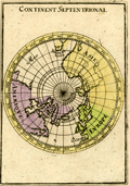 | Details | Mallet, Allain Manesson | 1685 |
| Antique Northern Hemisphere Polar Map |
|
Mallet, Allain Manesson |
|
| 1685 |
| LOC:41 |
| $90.00 | Mallet--Allain-Manesson | Antique-Northern-Hemisphere-Polar-Map | Small, hand-colored antique view of the northern hemisphere from a north polar perspective. Shows the so-called "Arctic Lands" with Greenland connected to northern Canada. Shows Iceland, Spitsbergen, and the "Terre de Iesso" or the Japanese island of Hokkaido . Fig 16.
<br></br>
By Allain Mallet, Paris, 1683 in a German edition of "Description de l'Univers" . Allain Mallet (1630-1706) was a French engineer, soldier, and cartographer. He served in the court of King Louis XIV as a techer of mathematics. In addition to "Description de l'Univers" Mallet also published "Les Travaux de Mars ou l'Art de la Guerre". |
| 1366 | 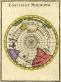 | Details | Mallet, Allain Manesson | 1683 |
| Antique Southern Polar Map of the World |
|
Mallet, Allain Manesson |
|
| 1683 |
| LOC:41 |
| $90.00 | Mallet--Allain-Manesson | Antique-Southern-Polar-Map-of-the-World | Small, hand-colored antique view of the globe from a south polar perspective. Shows the lower portions of Africa and South America. Incomplete and naïve representation of Australia, Tasmania, and New Zealand reflect that in the late 17th century knowledge of the geography of those areas was still incomplete. By Allain Mallet, Paris, 1683.
<br></br>
Published by Mallet in "Description de l'Univers" . Allain Mallet (1630-1706) was a French engineer, soldier, and cartographer. He served in the court of King Louis XIV as a teacher of mathematics. In addition to "Description de l'Univers" Mallet also published "Les Travaux de Mars ou l'Art de la Guerre". |
| 1353 | 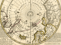 | Details | Moll, Herman | 1736 |
| Original Antique Polar Map of the North Pole |
|
Moll, Herman |
|
| 1736 |
| LOC:1 |
| $425.00 | Moll--Herman | Original-Antique-Polar-Map-of-the-North-Pole | Fine original antique 18th-century polar map of the <b>North Pole</b> annotated with observations and facts regarding early exploration of the north polar region. This striking polar projection shows Iceland, Greenland, Spitsbergen, Nova Zembla, portions of North America and Northern Europe. Text blocks at right and left detail the sun's movement at high latitudes and the explorations of the polar region by Frobisher, Davis and others
<br></br>
Printed for Tho: Bowles next ye Chapter House in St. Pauls Church Yard, & John Bowles at the Black Horse in Cornhill, London. |
| 1336 | 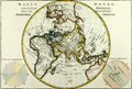 | Details | Bonne, Rigobert | 1787 |
| Eastern Hemisphere - Antique 45 Degree Northern Oblique Projection |
|
Bonne, Rigobert |
|
| 1787 |
| LOC:9 |
| $245.00 | Bonne--Rigobert | Eastern-Hemisphere---Antique-45-Degree-Northern-Oblique-Projection | Early antique projection covering the Eastern Hemisphere taken from 45 degrees north latitude. Includes the North Pole, northern North America with Alaska; Africa, Madagascar, Europe, Japan, western Australia (Nouvelle Hollande"), and New Zealand. A very fine copper-plate engraved map produced by Rigobert Bonne and crisply and finely engraved by Andre to include mountain ranges and numerous place names. Includes two related views on the plate including one colorful view of the "Sphere Oblique" and another obtuse drawing labeled "Effet de Pesanteur".
<br></br>
Rigobert Bonne (1727-1794) was the successor to Jacques Nicolas Bellin as Royal Cartographer to France in the office of the Hydrographer at the Depôt de la Marine. Bonne first came to prominence when he published a number of charts in the Atlas Maritime in 1762, but Bonne is better known for later publications, including the Atlas Encyclopedique, which he collaborated on with Nicholas Desmarest, as well as the maps he produced for Raynal's Atlas de Toutes Les Parties Connues du Globe Terrestre. Published in Paris in 1787. Plate 24. |
| 1306 | 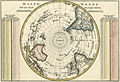 | Details | Bonne, Rigobert | 1787 |
| Antique Pre-Antarctica Southern Polar Projection |
|
Bonne, Rigobert |
|
| 1787 |
| LOC:9 |
| $325.00 | Bonne--Rigobert | Antique-Pre-Antarctica-Southern-Polar-Projection | Early antique South polar projection covering from the South Pole to the Equator. Produced by Bonne before the dimensions of continental Antarctica were known. This colorful antique map includes Australia (Nouvelle Hollande) and New Guinea.
<br></br>
Crisply and finely engraved to include mountain ranges and numerous place names with islands given extra coverage. Surrounded by two tables showing the distance corresponding to one degree at different latitudes. Published in Paris in 1787. Plate 23. |
| 1275 | 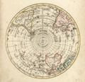 | Details | Walch, Johann | 1803 |
| Antique Southern Hemisphere polar view. |
|
Walch, Johann |
|
| 1803 |
| LOC:1 |
| $135.00 | Walch--Johann | Antique-Southern-Hemisphere-polar-view- | Attractive antique hand-colored <b>polar view</b> of the Southern Hemisphere. Perhaps most surprising about this copper-plate engraved polar map to modern eyes is the lack of an Antarctic Continent with its ice, which was not discovered by Europeans until much later. Published by Johann Walch, in his rare "Allgemeiner Atlas Nach den bewährsten Hülfsmitteln…", Augsburg, Germany, 1803.
<br></br>
Land details of this old map of the Southern Hemisphere include Van Dieman's Land (Tasmania), attached to Australia; Magellan's Land (Patagonia); Cook Strait in New Zealand; and Sandwich Land (not the Hawaiian Islands), discovered by Cook in 1775 and now the South Sandwich Islands. Notes the Amazon River, Congo, Madagascar, Paraguay, New Guinea, Java, and Borneo. |