| | Thumbnail | | Creator | Date | Title / Author / Date / Location | Price | | | Description |
| 2533 | 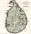 | Details | Bellin, Jacques Nicolas | 1753 |
| Antique Map of Sri Lanka |
|
Bellin, Jacques Nicolas |
|
| 1753 |
| LOC:6 |
| $350.00 | Bellin--Jacques-Nicolas | Antique-Map-of-Sri-Lanka | A fine antique map Sri Lanka (Ceylon or Ceylan), an island country in South Asia, located to the southwest of the Bay of Bengal and to the southeast of the Arabian Sea. Sri Lanka is separated from the Indian subcontinent by the Gulf of Mannar and the Palk Strait. Historically, Sri Lanka's geographic location and deep harbours made it of great strategic importance from the time of the ancient Silk Road through to the modern Maritime Silk Road.
<br></br>
Published in a French edition of L'Abbe Prevost's "Histoire Générale des Voyages", less than twenty years before Captain Cook's famous voyage. |
| 799 |  | Details | Robiquet, Aime | 1863 |
| Antique nautical chart of Sri Lanka or Ceylon |
|
Robiquet, Aime |
|
| 1863 |
| LOC:0 |
| $0.00 | Robiquet--Aime | Antique-nautical-chart-of-Sri-Lanka-or-Ceylon | SOLD
<br></br>
Antique French sea chart of the island of Sri Lanka, or as it was known before 1972- Ceylon. A large separately published steel plate navigational chart by French hydrographer and publisher Aime Robiquet. Includes the Southeast coast of India from Puducherry ("Pondicherry") extending south-westward, past Tuticorin ("Tutacorin") to Tiruchendur ("Trichindore"). Large French nautical chart encompasses the full extent of Sri Lanka and its offshore waters with numerous soundings, hazards, and coastal geographic features noted and named.
<br></br>
Includes two large inset harbor plans: of Colombo (1838), and Pointe de Galle (1858). Single horizontal fold as issued. Sparse interior detail is as common for many sea charts. |
| 5158 |  | Details | British Admiralty Hydrographical Office | 1864 |
| Antique Chart of the Bay and Harbor at Trincomalee Trincomalie Ceylon Sri Lanka |
|
British Admiralty Hydrographical Office |
|
| 1864 |
| LOC:59 |
| $400.00 | British-Admiralty-Hydrographical-Office | Antique-Chart-of-the-Bay-and-Harbor-at-Trincomalee-Trincomalie-Ceylon-Sri-Lanka | Chart of the Bay and Harbor of Trincomalee, an important port in Sri Lanka, which has been called the finest in the Indian Ocean. Published by the Hydrographical Office of the British Admiralty on July 3rd, 1834. Last corrected 1864.
<br></br>
The numerous key features on the map include Flagstaff Point, Fort Frederick, Lake Tamblegam, Great Bay, Norway Point, Elephant Ridge, Round Island, and Great Saber Island. Numerous soundings and marked anchorages.
<br></br>
In 1834 the Nautical Magazine described the chart:
<div class="indenttextblocksingle">
"Double-elephant. Includes the whole of Back Bay on the north and Great Bay on the south with Foul Point. It gives a complete view of the whole of the indented coast by which the harbour of Trincomalee is surrounded."
</div>
(Vol. 3, p. 690)
<br></br>
The same issue noted a similar sized but larger scale chart only of the "Harbour of Trincomalee" by Owen, Cannon, and Loring. |
| 5153 | 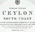 | Details | British Admiralty Hydrographical Office | 1875 |
| Antique Admiralty Chart of South Ceylon (Sri Lanka) |
|
British Admiralty Hydrographical Office |
|
| 1875 |
| LOC:59 |
| $1,150.00 | British-Admiralty-Hydrographical-Office | Antique-Admiralty-Chart-of-South-Ceylon-(Sri-Lanka) | Large nautical chart of south Sri Lanka (Ceylon) published in 1858 with last corrections in 1875. This scarce antique navigation chart was based on surveys by T.H. Twynam in 1833. The chart includes three finely engraved coastal elevation views- Colombo from the Outer Anchorage, Galle Light House, and Lion Peak.
side of Gan Island.
<br></br>
Five inset large-scale harbor charts include:
<div class="indenttextblocksingle">
<ul style="list-style-type: circle;">
<li>Colombo</li>
<li>Dodandowe Bay</li>
<li>Kirinde Road</li>
<li>Belligam Bay</li>
<li>Point de Galle Harbour</li>
</ul>
</div>
The sailing directions on this old chart make for interesting reading. For Belligam Bay the Admiralty recommended: "Keep the Cocoanut Trees on the point inside Woody Island well open until you bring Ruane Rock on with the east side of Gan Island."
<br></br>
The chart is titled: "Indian Ocean. Ceylon, South Coast. Surveyed by Mr. T.H. Twynam, Master Attendant at Point de Galle, 1833, with additions by Mr. James Steuart, Master, R.N., and E.I. Company's Officers."
<br></br>
Published by the Hydrographic Office of the Admiralty January 1858 by Captain Washington. Engraved by J and C. Walker. Sold by J.D. Potter, London. |