| | Thumbnail | | Creator | Date | Title / Author / Date / Location | Price | | | Description |
| 8038 | 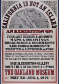 | Details | Anonymous | 1971 |
| Rare California Is Not an Island Oakland Museum Poster |
|
Anonymous |
|
| 1971 |
| LOC:130 |
| $400.00 | Anonymous | Rare-California-Is-Not-an-Island-Oakland-Museum-Poster | An original 1971 exhibition poster “California Is Not an Island,” produced for a special show at the Oakland Museum (Cowell Hall of California History), held May 30 to August 1, 1971. Designed in a bold nineteenth century broadside style with heavy slab-serif lettering in red and black, the sheet advertises an exhibition centered on early documentary materials relating to California’s exploration, overland migration, and Gold Rush-era development. <br><br>At the top is a halftone reproduction of a later embellished edition of Nicolas de Fer's map of California "La Californie ou Nouvelle Caroline", preserving the insular outline and early eighteenth century geographical nomenclature. The reference to Father Eusebio Kino acknowledges the Jesuit explorer whose overland expeditions proved that California was a peninsula, a conclusion directly contradicted by the island form shown here and central to the exhibition’s theme.<br><br>
The body of the poster lists the exhibit’s scope: overland diaries and accounts, maps and drawings, broadsides and documents, rare books, manuscripts, prints, and lithographs. The emphasis on primary sources underscores the museum’s intent to demonstrate how early travelers, scientists, and explorers recorded the region and how these records shaped the narrative of westward movement and the building of the transcontinental railroad. Only two publicly recorded sales of this poster are known.<br><br>
Only two sales of this poster are recorded on the Internet.
<br><br>
The Oakland Museum of California opened during 1969, created from the merger of three older institutions devoted to art, history, and natural science. Housed in a landmark terraced concrete complex by architects Kevin Roche and John Dinkeloo, it was conceived as a new kind of interdisciplinary museum dedicated to the story of California. |
| 8034 | 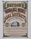 | Details | Mayson, Thomas | 1875 |
| Victorian exhibition advertisement for Mayson’s Relief Ordnance Model |
|
Mayson, Thomas |
|
| 1875 |
| LOC:89 |
| $200.00 | Mayson--Thomas | Victorian-exhibition-advertisement-for-Mayson’s-Relief-Ordnance-Model | Original Victorian exhibition advertisement for Mayson’s 3D Ordnance relief model of the Lake District, Cumbria, North West England, created in 1875 as a major visitor attraction in Keswick. The broadside announces the enormous 210 square foot model exhibited daily at the Lake District Repository on Lake Road, a sculpted landscape built to a scale of six inches to the mile and rendered with exactness from Ordnance Survey data. Bold Victorian lettering, fern motifs, and a vignette of the Repository building frame the promotional text, which highlights mountains, lakes, rivers, waterfalls, villages, and roads shown in full relief and hand colored to nature.
<br><br>
The model was commissioned by Keswick photographer Henry Mayson and his brother Thomas and built by the Italian sculptor Raffaelle Monti and his team using Ordnance Survey sheets as the mathematical basis for every contour. The advertisement stresses its practical value for travelers, noting that the model was an essential tool for planning excursions and understanding the correct topography of the Lake District at a time when tourism was rapidly increasing. Daily opening hours, illumination during summer months, and a one shilling admission charge appear prominently in the lower text block.
<br><br>
As an example of nineteenth century exhibition ephemera, this poster documents one of the most ambitious public relief models ever constructed in Britain and preserves the original marketing for a landmark Lake District attraction. Surviving advertisements for Mayson’s Ordnance Model are scarce, and this sheet stands as a desirable item for collectors of British posters, Lake District history, and early Ordnance Survey derived cartography. |
| 7927 |  | Details | Rambo, Ralph | 1971 |
| Santa Clara Valley sample map letter price list of Ralph Rambo |
|
Rambo, Ralph |
|
| 1971 |
| LOC:41 |
| $325.00 | Rambo--Ralph | Santa-Clara-Valley-sample-map-letter-price-list-of-Ralph-Rambo | A group of three artifacts that capture the spirit of California’s “Valley of Heart’s Delight” as seen through the eyes of Ralph Rambo (1894–1990)—the artist, humorist, and historian who chronicled old Santa Clara before it became Silicon Valley. Included is an autograph letter signed “Ralph Rambo” on his personal printed letterhead, dated circa 1971, in which the 76-year-old Rambo discusses his experience designing and selling maps as a “retirement pastime.” Written in his distinctive hand, the letter reflects his entrepreneurial wit and warm tone as he advises a fellow enthusiast on the economics of map publishing: “You are getting the very last of these maps... a handsome profit in map selling IF you have something GOOD with a wide appeal.”
<br><br>
Accompanying the letter are a salesman's' sample of Rambo’s pictorial map, -- Cartoon Pen and Inklings of the Old Santa Clara Valley — and Rambo's original price list for his illustrated works, all housed together in their original mailing envelope bearing Rambo’s Santa Clara return address. Together these three pieces form an evocative snapshot of a regional artist at work, combining correspondence, cartographic art, and period ephemera. An appealing and uncommon ensemble for collectors of California history, pictorial maps, or mid-century American illustration, they provide a glimpse into Rambo the entrepreneur. |
| 7920 |  | Details | Motion Picture Industry Guide Service | 1945 |
| Star Home Map Beverly Hills |
|
Motion Picture Industry Guide Service |
|
| 1945 |
| LOC:131 |
| $170.00 | Motion-Picture-Industry-Guide-Service | Star-Home-Map-Beverly-Hills | Printed “Star Home Map” issued by the Motion Picture Industry Guide Service of Beverly Hills, identifying more than one hundred homes of motion-picture stars in Beverly Hills and the western Hollywood Hills. Numbered locations correspond to an index naming Clark Gable, Gary Cooper, Judy Garland, Tyrone Power, Loretta Young, and a young Elizabeth Taylor. Taylor’s inclusion—following her 1944 breakthrough in National Velvet—places this edition around 1944–45.
<br><br>
Printed in blue on yellow stock with whimsical patriotic artwork, the map reflects the early days of Hollywood tourism when visitors sought celebrity homes using printed street guides. An appealing survivor of mid-1940s film-era ephemera that captures the glamour and geography of the movie colony at its wartime peak.
<br><br>
Published by Motion Picture Industry Guide Service, Beverly Hills, California.
Ted Ambrose, Acting Director, Santa Monica Mountains Estate.
Issued under the auspices of I.S.O.M.P.A. (International Screen and Motion Picture Association). |
| 7877 | 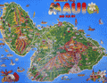 | Details | Island Funnies | 1990 |
| Cute Pictorial Map Poster of Maui, Hawaii |
|
Island Funnies |
|
| 1990 |
| LOC:130 |
| $195.00 | Island-Funnies | Cute-Pictorial-Map-Poster-of-Maui--Hawaii | <br><br>
Cute pictorial map poster of Maui, Hawaii by Island Funnies (1990) - licensee of Fiesta Cartoon Maps. The map highlights local parks and recreational activities including scuba diving, golf, fishing, sailing, and surfing.
<br><br>
Maui, the second-largest island in Hawaii, has a rich history dating back to ancient Polynesian settlers. The island was first settled by Polynesians who navigated the Pacific Ocean using the stars, arriving in Hawaii around 400-800 AD. These early settlers developed a complex society with a strict social hierarchy and a subsistence economy based on fishing and agriculture.
<br><br>
In the late 18th century, European explorers arrived in Hawaii, with Captain James Cook being the first recorded European to visit Maui in 1778. The island later became a center for the whaling industry and a popular port for ships traveling between North America and Asia.
<br><br>
Lahaina, located on the west coast of Maui, was once the capital of the Hawaiian Kingdom in the early 19th century. It was also a major whaling port and a center of commerce. Today, Lahaina is a popular tourist destination known for its historic buildings, art galleries, and restaurants.
<br><br>
Kapalua, situated on the northwest coast of Maui, was once a plantation growing pineapples and coffee. In the 1970s, the area was transformed into a resort destination featuring world-class golf courses, luxurious accommodations, and pristine beaches.
<br><br>
Haleakala, a massive shield volcano that forms the eastern portion of Maui, is a significant feature of the island. The volcano's crater is a popular destination for hiking, stargazing, and watching the sunrise. In 1916, Haleakala National Park was established to protect the unique volcanic landscape and the endemic species that inhabit the area.
<br><br> |
| 7875 | 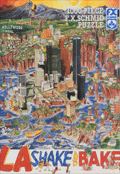 | Details | Holladay, John | 1992 |
| Rare Apocalyptic Los Angeles After Earthquake Puzzle |
|
Holladay, John |
|
| 1992 |
| LOC: |
| $385.00 | Holladay--John | Rare-Apocalyptic-Los-Angeles-After-Earthquake-Puzzle | Scarce and fun 1000 piece pictorial puzzle titled LA Shake and Bake, created in 1992 by illustrator John Holladay and published by F. X. Schmid. Puzzle is unopened in original shrink wrap as issued. <br><br>The puzzle presents a satirical pictorial view of Los Angeles shattered by a massive quake, with districts sliding toward the Pacific Ocean in a dense and humorous cartoon style. The image plays on long standing California earthquake lore. It was also issued by Schmid as an uncut poster. When assembled, the puzzle measures 26.5 by 17.25 inches.<br><br>
Holladay's theme draws on the popular misconception that California might someday break off along the San Andreas Fault, an idea that traces back to public misunderstanding of Andrew Lawson's 1906 report describing lateral motion after the San Francisco earthquake. His phrasing that the Pacific side moved northward relative to the American side echoed for decades, inspiring exaggerated public fears and giving artists like Holladay fertile ground for satirical disaster scenes. The puzzle captures that cultural myth with vivid color and a chaotic, engaging layout.<br><br>
LA Shake and Bake also reflects the long publishing history of F. X. Schmid, founded in Munich in 1860 and best known for toys, cards, and later board games and puzzles. By the 1970s and 1980s the company had expanded internationally, including a U.S. division that produced widely distributed puzzles like this one. Financial pressures in the mid 1990s led to a 1997 merger with Ravensburger, marking the end of Schmid as an independent maker. This puzzle stands as one of the imaginative late period Schmid releases, combining contemporary humor, geological lore, and striking packaging design.
<br><br>
Box size roughly 15.5" x10". |
| 7864 | 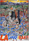 | Details | Holladay, John | 1992 |
| Pictorial Poster View of Los Angeles Submerged After Earthquake |
|
Holladay, John |
|
| 1992 |
| LOC:89 |
| $800.00 | Holladay--John | Pictorial-Poster-View-of-Los-Angeles-Submerged-After-Earthquake | Fine medium-format satirical poster of Los Angeles titled LA Shake and Bake, created in 1992 by illustrator John Holladay. Very rare, with no institutional holdings found in WorldCat and no recorded sales of the poster on the Internet. <br><br>The artwork presents a dramatic cartoon vision of the city shattered by a massive quake, with hills cleaving open, and whole neighborhoods transformed into islands in a rising blue sea. Holladay fills the sheet with humorous detail, from boats navigating through canyon walls to crowds celebrating on newly formed shorelines. The Hollywood Hills, downtown high rises, and coastal districts are all reimagined as fragments of a fractured landscape, creating a lively blend of regional caricature and disaster fantasy that reflects long standing popular myths about California earthquakes.<br><br>
Issued by Holladay Prints independent of the moderately rare F. X. Schmid puzzle edition (in stock 12/25), this poster allows the viewer to appreciate the full composition without the grid of puzzle cuts. The image captures the playful anxiety of early 1990s Los Angeles culture, shaped by real seismic events like the 1992 Landers sequence and by public misconceptions that California might one day fall into the Pacific. With its bright palette, dense pen work, and packed narrative scenes, LA Shake and Bake stands as a memorable example of late twentieth century pictorial satire devoted to one of America’s most iconic urban landscapes. |
| 6869 | 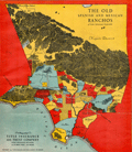 | Details | Title Insurance and Trust Company Los Angeles | 1929 |
| Rare Map Old Spanish and Mexican Ranchos of Los Angeles County |
|
Title Insurance and Trust Company Los Angeles |
|
| 1929 |
| LOC:78 |
| $1,350.00 | Title-Insurance-and-Trust-Company-Los-Angeles | Rare-Map-Old-Spanish-and-Mexican-Ranchos-of-Los-Angeles-County | "The Old Spanish and Mexican Ranchos of Los Angeles County" is apparently the first advertising map of that title published by the Title Insurance and Trust Company of Los Angeles, just one year after the firm was incorporated in 1928. Compared to later editions this earliest 1929 edition appears as though it was produced more quickly, fitting for a company that was just beginning to take advertising seriously. The 1929 edition is smaller, more colorful, and much less elaborately executed than two later maps by the same name that the firm published in 1930 and 1937.
<br><br>
Rare. Not found in Rumsey or WorldCat.
<br><br>
Compared to the 1930 edition the 1929 edition lacks the elaborate compass rose and distance scale, the Spanish missions are drawn more simply and they lack the founding dates found in the 1930 edition. In the 1930 edition the artist has labeled public lands as such, and has filled the Pacific Ocean with a sailing ship, flying fish, and sea monsters, familiar scenes that cartographers have used for hundreds of years.
<br><br>
Title Insurance Building. 433 So. Spring Street. Los Angeles. Copyright 1929.
<br><br> |
| 6868 |  | Details | Anonymous | 1940 |
| Pictorial Map Metropolitan Oakland California Pre-war |
|
Anonymous |
|
| 1940 |
| LOC:89 |
| $300.00 | Anonymous | Pictorial-Map-Metropolitan-Oakland-California-Pre-war | Scarce unattributed pictorial map of the metropolitan Oakland, California. Likely dates to circa 1940 based on the aircraft style in one of the photographic vignettes and the fact that the Oakland Bay Bridge, built 1936, appears on the map. Unsigned and undated. |
| 6862 | 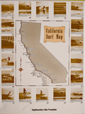 | Details | Anonymous | 1970 |
| California Surf Map |
|
Anonymous |
|
| 1970 |
| LOC:130 |
| $2,000.00 | Anonymous | California-Surf-Map | <br><br>
<div class="indenttextblock" style="text-align: center; font-size: 1.2em;"><b>
Let's go surfin' now<br>
Everybody's learnin' how<br>
Come on and safari with me<br></b>
</div>
<br>
Very rare California Surf Map circa late 1960's to early 1970's. Apparently produced to support a sales promotion. The map at center is surrounded by photo illustrations of popular California surfing locations. Each location contains a brief description of when to expect the best surfing conditions. For example: <div class="indenttextblock">"MISSION BEACH Typical beach surf winter and summer. Less crowded than Pacific Beach. Takes all swells with south and west swells preferred. 2 - 6 feet ht."</div>
<br>
Surfing locations identified on the map include, from bottom right moving clockwise:
<div class="indenttextblocksingle">
<ul style="list-style-type: circle;">
<li>Mission Beach</li>
<li>Pacific Beach</li>
<li>Leucadia</li>
<li>Oceanside</li>
<li>San Clemente</li>
. . .
<li>Manhattan Beach</li>
<li>Malibu</li>
<li>Ventura</li>
<li>Staley's</li>
<li>Rincon</li>
</ul>
</div>
Only one copy was found online, at the archive for surfingheritage.org (1).
<br><br>
(1) http://archive.surfingheritage.org/2015/02/vintage-map-of-california-surf-spots.html |
| 6845 |  | Details | Fairchild Aerial Surveys Inc. | 1930 |
| Scarce view of Hollywood Stars Homes Beverly Hills |
|
Fairchild Aerial Surveys Inc. |
|
| 1930 |
| LOC:89 |
| $400.00 | Fairchild-Aerial-Surveys-Inc- | Scarce-view-of-Hollywood-Stars-Homes-Beverly-Hills | Scarce, early photographic oblique "airplane" birds-eye view of Beverly Hills, California annotated with numerals keyed to homes of Hollywood stars. These movie stars include Buster Keaton, Tom Mix, Mary Pickford, Douglass Fairbanks, Charles Chaplin, Marlene Dietrich, and Will Rogers. The view probably dates between 1926 and 1933 based on the marriage duration of King Vidor and Eleanor Boardman (Home # 22) . By Fairchild Aerial Surveys, N.Y.C. Published in an unknown magazine. Verso with glamour photographs of period stars.
<br><br>
The view looks roughly north with the Beverly Hills Hotel, established 1912, slightly to the left of the center. This item may be the earliest published aerial photograph of Photomap of Beverly Hills to locate the homes of movie stars and likely predates Landacre's "Newe Mappe of the Heavens."
<br><br><div class="indenttextblocksingle">
"When Wallace Beery flies back from his island camp, or when Ben Lyon volplanes down home to see Bebe and the baby, this is where the magic carpet of Hollywood looks to the returning wanderers of the sky."
</div><br> |
| 6800 |  | Details | Dagelet, Joseph Lepaute | 1797 |
| Original antique French nautical chart of the west coast of North America |
|
Dagelet, Joseph Lepaute |
|
| 1797 |
| LOC: |
| $800.00 | Dagelet--Joseph-Lepaute | Original-antique-French-nautical-chart-of-the-west-coast-of-North-America | Original antique nautical chart of the west coast of North America from Mt. St. Elias (1) to Monterey Bay. Shows route of la Perouse. Includes the west coasts of California, Washington, and Oregon. From the atlas of the voyage by Lapérouse. Plate 16.
<br><br>
Jean-François de Galaup, Comte de Lapérouse was a French Naval officer and explorer whose journey started in 1785 under the commission of King Louis XVI. The expedition comprised two ships, the Astrolabe and the Boussole, and a crew of 225. The crew included scientists and artists who were tasked with documenting various aspects of the journey, including geography, wildlife, and indigenous cultures. This expedition aimed to complete the Pacific explorations undertaken by Captain Cook and others. The journey is noted for its tragic disappearance of Laperouse near the end.
<br><br>
The disappearance of Lapérouse's expedition sparked much interest and concern, leading to numerous rescue and search missions. The wreckage of the two ships was finally discovered in 1826 near Vanikoro, an island in the Solomon Islands, but the exact circumstances of the expedition's end remain a mystery.
<br><br>
(1) Mount St. Elias, located on the border between Alaska in the United States and Yukon in Canada, is one of the highest peaks in North America, at an elevation of 18,008 feet. It forms part of the St. Elias Mountain Range, which hosts some of the most extensive ice fields in the world. |
| 6795 |  | Details | Delkin, James Ladd | 1944 |
| WWII-era Map of San Francisco, California |
|
Delkin, James Ladd |
|
| 1944 |
| LOC:89 |
| $195.00 | Delkin--James-Ladd | WWII-era-Map-of-San-Francisco--California | Original WWII-era street map of San Francisco, California with sketches of local life including a cable car, a machine-gun emplacement near the Golden Gate Bridge, and a sailor carrying a duffel bag. War housing projects scattered across the city are outlined in red. The map was originally attached within a small brochure published ca. 1944 by James Ladd Delkin: "All About San Francisco, Illustrated Map and Guide."
<br><br>
Verso with a map of Golden Gate Park and Panhandle by the San Francisco Board of Park Commissioners Division of Engineering and Landscape Design.
<br><br>
During World War II, San Francisco experienced significant changes in its housing landscape to accommodate the needs of the military. The city experienced a surge in population due to the influx of military personnel and defense workers, leading to a severe housing shortage. To address the housing shortage, the federal government, in collaboration with local authorities, initiated several public war housing projects. Projects highlighted in red on this map include:
<div class="indenttextblocksingle">
<ul style="list-style-type: circle;">
<li>Hunters Point Annex: The Hunters Point Annex, located in the southeastern part of San Francisco near the Hunters Point Naval Shipyard, was a housing development constructed for defense workers. It provided temporary housing during the war years.</li>
<li>Sunnydale Housing Development: Situated in the Visitacion Valley neighborhood of San Francisco.</li>
<li>Potrero Terrace and Annex: Built in the Potrero Hill neighborhood of San Francisco. </li>
<li>Oakdale</li>
<li>Candlestick Cove</li>
</ul>
</div> |
| 6787 | 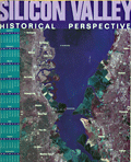 | Details | The Original Silicon Valley Map and Calendar | 1998 |
| Silicon Valley Historical Perspective Calendar Labeled Map |
|
The Original Silicon Valley Map and Calendar |
|
| 1998 |
| LOC: |
| $295.00 | The-Original-Silicon-Valley-Map-and-Calendar | Silicon-Valley-Historical-Perspective-Calendar-Labeled-Map | A sponsored calendar listing notable events for the 100 sponsoring firms in the Santa Clara Valley, Silicon Valley, California. Events range over a period from 1891 when Leland Stanford Jr. University opened near Palo Alto, through 1998 when Hexcel Corporation celebrated its 50th anniversary. Satellite photomap of Silicon Valley labeled with a numerical index sourced from the event table at right.
<br><br>
With large advertisement for the map's primary sponsor, Computer Literacy, that offered "computer and electronics books and related services to its customers through its retail stores and online."
<br><br>
Copyright 1997 by The Original Silicon Valley Map and Calendar a division of Amen International, San Jose California. Designed by OnTarget and printed by Benjamin Litho.
<br><br>
Other key events include:
<div class="indenttextblocksingle">
<ul style="list-style-type: circle;">
<li>1970 | Xerox Palo Alto Research Center is founded.</li>
<li>1976 | Wozniak and Jobs found Apple Computer.</li>
<li>1981 | IBM introduces the first IBM PC.</li>
<li>1987 | Microsoft PowerPoint introduced.</li>
<li>1995 | Sun Microsystems introduces Java.</li>
<li>1997 | Apple acquires Next with Steve Jobs.</li>
</ul>
</div> |
| 6784 |  | Details | Silicon Maps Inc. and Trestria Inc. | 2008 |
| 2008 Pictorial Calendar Map of Silicon Valley California |
|
Silicon Maps Inc. and Trestria Inc. |
|
| 2008 |
| LOC:11111 |
| $600.00 | Silicon-Maps-Inc--and-Trestria-Inc- | 2008-Pictorial-Calendar-Map-of-Silicon-Valley-California | Scarce "Classic Edition" Silicon Valley map and calendar copyrighted 2008 by Silicon Maps Inc. and Testria, Inc. Sponsored by Citrix, 4988 Great America Parkway, Santa Clara, California. Glossy finish as issued. |
| 6782 |  | Details | City Design | 1991 |
| Pictorial Advertising Map of San Jose, California |
|
City Design |
|
| 1991 |
| LOC:111111 |
| $1,600.00 | City-Design | Pictorial-Advertising-Map-of-San-Jose--California | Scarce pictorial advertising map of San Jose, California at the heart of Silicon Valley. A late 20th-century map produced and copyrighted by City Design of Pleasanton, California, in 1991. Names and phone numbers of sponsoring businesses appear in banners in the general vicinity of the business' address.
<br><br>
<div id="6782" align="center">
<a title=""></a>
<img id="6782" src="/ZoomifyImages/SC_6782/SC_6782_detail_1.jpg" alt="Detail from City Design map of San Jose, California. 1991." width="340"/> <br><br> <font size="-2">Detail from 1991 City Design map of San Jose, CA.</font>
</div><br> |
| 6775 |  | Details | Mikkelsen and Associates | 1991 |
| Silicon Valley Pictorial Advertising Map Spirit of Innovation |
|
Mikkelsen and Associates |
|
| 1991 |
| LOC:150 |
| $4,400.00 | Mikkelsen-and-Associates | Silicon-Valley-Pictorial-Advertising-Map-Spirit-of-Innovation | Pictorial map poster for Silicon Valley, California by Mikkelsen and Associates, 1991. The creator identifies San Jose as the "Capital of Silicon Valley." Very scarce in this version, lacking a calendar.
<br><br>
<div id="0" align="center">
<a title=""></a>
<img id="6775" src="/ZoomifyImages/SC_6775/SC_6775_detail_1.jpg" alt="Pictorial map poster for Silicon Valley, California by Mikkelsen and Associates, 1991" width="340"/> <br><br> <font size="-2"> Capital of Silicon Valley, San Jose, CA.</font>
</div><br>
The poster was commissioned and copyrighted by Access Global Inc. 1992 (1). With the San Francisco skyline visible at upper left, the poster map shows elevation views of local tech firm buildings and other businesses, each identified with the firm's name and logo. These include:
<br><br>
<div class="indenttextblocksingle">
<ul style="list-style-type: circle;">
<li>Mylex</li>
<li>Phase Two Industries</li>
<li>Synoptics</li>
<li>Hitachi Data Systems</li>
<li>Zilog</li>
<li>Sierra Semiconductor</li>
<li>Jabil Circuit</li>
<li>Photronics</li>
</ul>
</div>
(1) Access Global, Inc. Milpitas, California. Access Global, Inc. was incorporated in 1991. That firm's trademark was "Spirit of Innovation. |
| 6750 | 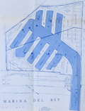 | Details | Nicholson, George F. | 1956 |
| Unrecorded Marina del Rey Economic Study |
|
Nicholson, George F. |
|
| 1956 |
| LOC:2001 |
| $950.00 | Nicholson--George-F- | Unrecorded-Marina-del-Rey-Economic-Study | Unrecorded, detailed analytical economic report "Marina del Rey Economic Study" produced March 5, 1956 by George F. Nicholson, C.E. Consulting Engineer.
<br><br>
A detailed report by Nicholson bound with transmittal letter and six-page summary from Nicholson to J.A. Lambie, Los Angeles County Engineer. Hard cover. 79 pages text. Table of Contents. Three maps. One site photograph. Four tables. Manuscript signature inside cover for Walt Petty.
<br><br>
Rare. No copy of this report is found anywhere online. |
| 6735 | 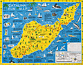 | Details | Ramsey, George | 1947 |
| Scarce pictorial fun map of Santa Catalina Island |
|
Ramsey, George |
|
| 1947 |
| LOC:89 |
| $295.00 | Ramsey--George | Scarce-pictorial-fun-map-of-Santa-Catalina-Island | <br><div class="indenttextblocksingle"><b>For a lasting remembrance of a grand vacation!</b> Keep this souvenir fun-map and mark the points you visit and the dates. Trace the routes of your travels on Catalina. Send copies to friends</div>
<br><br>
Where to go - What to see Santa Catalina Island fun map. A post-WWII pictorial map of Catalina Island, California. Copyright by George Ramsey. Published 1947 by Recreation Publishing Company, Los Angeles, CA. Price when issued 25 cents. Features include: Location of Ling-Ho Chinese junk movie set; Seal Rocks; submarine gardens; Chicago Cubs Ball Park and training grounds; the Catalina Visitors Country Club and much more.
<br><br>
Verso with map for Avalon Town |
| 6714 | 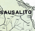 | Details | Northwestern Pacific Railroad | 1931 |
| Hiking Map Marin County California |
|
Northwestern Pacific Railroad |
|
| 1931 |
| LOC:68 |
| $375.00 | Northwestern-Pacific-Railroad | Hiking-Map-Marin-County-California | Original Hiking Map of Marin County California copyrighted and first issued by the Northwestern Pacific Railroad Company (NWPRR) in 1925 [1931]. Shows both hiking trails and fire trails with the greatest concentration around the area of Mt. Tamalpais, Muir Woods, Lagunitas Lake, and Alpine Lake. Scarce on the market. Only 5 institutional holdings of the map are listed in WorldCat.
<br><br>
Includes an inset detail map of Mill Valley with an approx. 1/2 mile walking route from the NWPRR station to the trailhead of the Pipeline Trail. No contour lines but the map does show the elevation at many points. The map shows many identified hiking trails including:
<br>
<div class="indenttextblocksingle">
<ul style="list-style-type: circle;"></li>
<li>Boot Jack Trail</li>
<li>Rock Spring Trail</li>
<li>Hidden Lake Fire Trail</li>
<li>Cataract Trail</li>
<li>Bolinas Ridge Trail</li>
<li>Woodacre Fire Trail</li>
<li>Lagunitas Fire Trail</li>
<li>Indian Fire Trail</li>
</ul>
</div>
This a revised edition from 1931. Edward Denny & Co. Publishers, San Francisco. Manuscript marginal note: "1939."
<br><br> |
| 6712 |  | Details | Red Mountain Tribe | 1970 |
| Terrorism 1970's style |
|
Red Mountain Tribe |
|
| 1970 |
| LOC:86 |
| $200.00 | Red-Mountain-Tribe | Terrorism-1970-s-style | This is a title page to a 1970 issue of the Berkely Tribe newspaper- an anthropomorphized earth scowling with locations noted across his face that were the scene of left-inspired bombings, fire bombings, pipeline attacks, the odd embassy siege, and riots. Published in 1970, during the Vietnam war by the Red Mountain Tribe (1) with parallels to the tensions experienced today by the other side of the aisle.
<br><br>
The use of symbols as propaganda was a common tactic among activists during this time, and the Earth was a particularly powerful symbol of the counterculture's environmentalism and concern for the planet. By depicting the Earth as an old man with a scowl, the artist was likely attempting to convey a sense of anger and frustration at the destruction caused by the war and other government policies. The Earth's face being marked with locations that were the scene of attacks further reinforced the counterculture's proposition that the US government was engaging in destructive and unjust actions.
<br><br>
<div id="0" align="center">
<a title="Berkeley Tribe 1970"></a>
<img id="3" src="/ZoomifyImages/SC_6712/SC_6712_detail.jpg" alt="Anthropomorphized view of earth scowling with locations noted across his face that were the scene of left-inspired terror attacks." width="340"/> <br><small>... What's the world coming to?</small>
</div><br>
Berkely Tribe. 1970. Vol. 2 No. 8 Issue 34. Feb. 27 - Mar.6, 1970.
<br><br> |
| 6702 |  | Details | Mathis, George | 1947 |
| Scarce pictorial map of the Feather River Basin |
|
Mathis, George |
|
| 1947 |
| LOC:87 |
| $325.00 | Mathis--George | Scarce-pictorial-map-of-the-Feather-River-Basin | A boomer-era 'cartogravure' of the Feather River Basin by George Mathis on the verso of a folding brochure for Gray Eagle Lodge in Blairsden, Plumas County, California. Dated within at 1955 in a hand-stamp on the recto. Coverage includes the Feather River, Long Lake, Gold Lake, Mud Lake, Smith Lake, Mt. Elwell, Frazier Falls, Mohawk Creek, Mills Peak and more.
<br><br>
The Feather River is a major river in Northern California, USA, with a length of about 71 miles. It is a tributary of the Sacramento River and is known for its scenic beauty, recreational opportunities, and historic significance.
<br><br>
During the California Gold Rush of the mid-19th century, the Feather River became an important source of gold. Miners used hydraulic mining techniques to extract gold from the riverbed, which caused significant environmental damage and siltation of the river. The discovery of gold in the Feather River contributed to the growth of several nearby towns, including Oroville and Marysville.
<br><br>
In the early 20th century, the Feather River became a focal point of water development projects aimed at supplying water to the growing population and agricultural needs of California. The Oroville Dam, completed in 1968, is the tallest dam in the United States and forms Lake Oroville, a major reservoir that stores water from the Feather River. |
| 6696 | 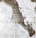 | Details | U. S. Navy Oceanographic Office | 1964 |
| United States Navy Chart of Baja California. |
|
U. S. Navy Oceanographic Office |
|
| 1964 |
| LOC:68 |
| $225.00 | U--S--Navy-Oceanographic-Office | United-States-Navy-Chart-of-Baja-California- | Very large original U. S. Navy chart of the Baja Peninsula and the Gulf of California. U.S. and British Admiralty charts of Baja California are among the most requested items on RareCharts.
<br><br>
Dark shading on land areas enhances the contrast between land and sea. Manuscript traces of faded writing.
<br><br>
<div id="0" align="center">
<a title=""></a>
<img id="6648" src="/ZoomifyImages/SC_6696/SC_6696_detail.jpg" alt="Very large original U. S. Navy chart of the Baja Peninsula and the Gulf of California, 1964" width="340"/> <br><br> <font size="-2">Baja- La Paz Bay and Isla Espiritu Santo</font>
</div><br>
"Mexico - West Coast Cabo San Lazaro to Cabo San Lucas and Southern Part of Golfo de California. From U. S. Navy Surveys between 1873 and 1901 with additions in 1962". 1st edition was in 1876 but this 68th edition last revised in June, 1964. Mercator projection. Catalog region 2. Chart # 621. |
| 6682 | 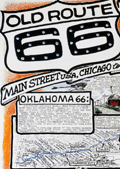 | Details | Waldmire, Robert | 1999 |
| Old Route 66 Pictorial Map Poster Chicago to L.A. 4th Final edition |
|
Waldmire, Robert |
|
| 1999 |
| LOC:300 |
| $140.00 | Waldmire--Robert | Old-Route-66-Pictorial-Map-Poster-Chicago-to-L-A--4th-Final-edition | The "Old Route 66 Main Street U.S.A. Chicago to L.A." poster created by Robert Wildmire is a highly detailed and intricate compilation of maps, historical facts, and drawings related to the famous Route 66 highway that stretches across the U.S. from Chicago to Los Angeles. Includes numerous inset illustrations and larger scale detailed road map fragments. A few of the more unusual locations on the poster, along Route 66 are:<br><br>
<div class="indenttextblocksingle">
<ul style="list-style-type: circle;"></li>
<li>The U-Drop Inn in Shamrock, Texas.</li>
<li>The Blue Swallow Motel in Tucumcari, New Mexico</li>
<li>The Cadillac Ranch, "just West of Amarillo".</li>
</ul>
</div>
First printing 5000 copies, of what Wildmire considered to be the "fourth and final incarnation" of the Route 66 map. According to a note on the poster,
<br><br>
<div class="indenttextblocksingle">"this color map originally appeared in National Parks Magazine (Mar. - Apr. '91). It was subsequently reprinted (in 2 editions, both out-of-print collectibles by now) by Dan Harlow of Rt. 66 Clothing & Goods, by arrangement with the artist."
</div>
<br>
Wildmire explains how this map differs from the three previous editions:<br><br>
<div class="indenttextblocksingle">
"I have added new color drawings & included my set of 8 "66 state postcard strip maps," showing each state's alignment in detail. I have added color to indicate the drivable through stretches (shown in blue) and those stretches on unavoidable Interstate (shown in red). "
</div>
<br>
<div id="0" align="center">
<a title="Baxter Springs"></a>
<img id="3" src="/ZoomifyImages/SC_6682/SC_6682_detail.jpg" alt="Baxter Springs, Kansas. Home of Ruth-anne and Lynn's Biker Bar." width="320"/> <br><small>Drill down view near Baxter Springs, Kansas.</small>
</div><br>
Printed by Frye-Williamson Press Springfield, Illinois Copyright 1999 |
| 6658 |  | Details | Mount Tamalpais and Muir Woods Railroad | 1923 |
| Birds eye view Map of the Pacific Coast in the vicinity of San Francisco |
|
Mount Tamalpais and Muir Woods Railroad |
|
| 1923 |
| LOC:3 |
| $295.00 | Mount-Tamalpais-and-Muir-Woods-Railroad | Birds-eye-view-Map-of-the-Pacific-Coast-in-the-vicinity-of-San-Francisco | An attractive original antique four-panel bird's eye view / map of the California Pacific coast in the vicinity of San Francisco Bay and San Pablo Bay from 1923.
<br><br>
Elevation is shown in relief. The view stretches from Mount Shasta at top left to the Farallon Islands at the bottom right and extends from Lake Lagunitas at bottom left to Mount Hamilton. Includes towns ranging around San Pablo Bay and San Francisco Bay: San Jose, San Francisco, Palo Alto, Oakland, Sausalito, Napa, Sonoma, and Walnut Creek. At bottom left is a table of air line distances from the summit of Mt. Tamalpais. Sacramento is 73 miles distant and Mt. Shasta a long 237 mile crow-flight from Mt. Tamalpais.
<br><br>
The map comprises four of eight panels of a brochure issued by the Mount Tamalpais and Muir Woods Railroad. Printed by Leighton Press, San Francisco, California. Dated in the plate at 1923. Verso includes photos and text. |
| 6638 | 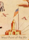 | Details | G.M. Hopkins Co. | 1941 |
| Pictorial Map of the Southwest United States |
|
G.M. Hopkins Co. |
|
| 1941 |
| LOC:89 |
| $75.00 | G-M--Hopkins-Co- | Pictorial-Map-of-the-Southwest-United-States | A fine decorative pictorial map of the United States Southwest that plays to many of the stereotypes of the era for that region. One interesting feature near the center of Texas is a depiction of an airplane taking off from "West Point of The Air". West Point of The Air was the name of a 1935 American movie about pilot training at Randolph Field, about 15 miles northeast of San Antonio, Texas. Between October 1931 and March 1935, more than 2,000 candidates reported for pilot training at Randolph Field.
<br><br>
At upper right an inset "Transportation Map of the Picturesque Southwest. With legend showing routes used by aircraft, railroads, and automobile.
<br><br>
Anonymous author, but signed illegibly in the plate at bottom right.
<br><br>
Published in Picturesque Southwest by Picturesque Publications, November, 1941. |
| 6614 |  | Details | San Francisco Harbor Commission Board | 1940 |
| Detailed Map of San Francisco Waterfront 1940 |
|
San Francisco Harbor Commission Board |
|
| 1940 |
| LOC:1403 |
| $650.00 | San-Francisco-Harbor-Commission-Board | Detailed-Map-of-San-Francisco-Waterfront-1940 | A 55 inch long detailed planning map of the Harbor of San Francisco, California dated 1940. Produced by the Board of State Harbor Commissioners for San Francisco Harbor, Frank White, Chief Engineer. Rare.
<div><img src="/ZoomifyImages/SC_6614/SC_6614_title_detail.jpg" alt="Close-up detail from the title of the Map of the Waterfront of San Francisco 1940 by SF Harbor Commissioners" width="300" align="center" style="margin: 20px 0px 20px 20px"/>
</div>
Documents harbor development in 1940 in minute detail. Coverage sweeps along San Francisco Bay from the South Basin westward and then northward past the Aquatic Park and Fort Mason. Delineates the extent of both the pier head line and the waterfront line. Details each wharf and shows measurements of every space along the waterfront with pier lengths and pier slip widths as well as the very extensive railroad yards and rail lines connected to each dock. Most of these railroad tracks do not exist today.<div><img src="/ZoomifyImages/SC_6614/SC_6614_wharf_detail.jpg" alt="Close-up detail of the waterfront piers near Fisherman's Wharf in San Francisco, California in 1940." width="300" align="center" style="margin: 20px 0px 20px 20px"/>
</div>
Photo-lithograph on a 55" long rolled sheet of thin translucent paper. |
| 6592 | 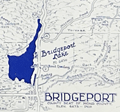 | Details | Hayden, Walter Emmet | 1952 |
| West Walker River Topaz Lake Directory Fishing Hunting Map 1952 |
|
Hayden, Walter Emmet |
|
| 1952 |
| LOC:89 |
| $350.00 | Hayden--Walter-Emmet | West-Walker-River-Topaz-Lake-Directory-Fishing-Hunting-Map-1952 | 1959 revised edition of the Hayden Map Company's Hunter's and Fisherman's map for the Topaz Lake / West Walker River area of Mono County, California. Map # 598141. Copyright 1952. Verso blank.
<br><br>
Very fine detail, printed in blue, ink based on surveys from 1923 to 1952.
<br><br>
Scarce today. Price was 50 cents when issued.
<br></br> |
| 6593 | 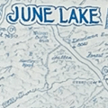 | Details | Hayden, Walter Emmet | 1960 |
| June Lake Lee Vining Directory Map Fishing Hunting Map |
|
Hayden, Walter Emmet |
|
| 1960 |
| LOC:89 |
| $160.00 | Hayden--Walter-Emmet | June-Lake-Lee-Vining-Directory-Map-Fishing-Hunting-Map | 1960 revised edition of the Hayden Map Company's Hunter's and Fisherman's map for the June Lake / Lee Vining area of Mono and Inyo Counties, California. Map # 61912. Copyright 1952. Verso blank.
<br><br>
Price was 50 cents when issued. Printed in bright blue ink.
<br><br>
Inset small-scale context map of California. |
| 6594 | 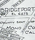 | Details | Hayden, Walter Emmet | 1954 |
| Northern Mono County Bridgeport Fishing Hunting Map |
|
Hayden, Walter Emmet |
|
| 1954 |
| LOC:89 |
| $350.00 | Hayden--Walter-Emmet | Northern-Mono-County-Bridgeport-Fishing-Hunting-Map | 1954 edition of the Hayden Map Company's Hunter's and Fisherman's Map and Resort Directory of Northern Mono County with Bridgeport, California. Map # 1162954. Copyright 1954. Verso blank. No price.
<br><br>
Inset small-scale context map of California. North oriented to bottom. |
| 6595 |  | Details | Hayden, Walter Emmet | 1939 |
| Olancha to Sierraville tourists driving map Bullocks advertisement |
|
Hayden, Walter Emmet |
|
| 1939 |
| LOC:89 |
| $275.00 | Hayden--Walter-Emmet | Olancha-to-Sierraville-tourists-driving-map-Bullocks-advertisement | 1939 Two-sided black and white edition of the Hayden Map Company's Olancha to Sierraville tourist's auto map sponsored in part by Bullock's Sporting Goods. Interesting inset large-scale detailed maps of the Reno, Nevada Business District, Bridgeport Business District, Leevining Business District, and a very unusual inset circular 360 degree mileage chart of points south and east of Tahoe City. Includes Lake Tahoe, Truckee, Reno.
<br><br>
Map # 825419. Copyright 1939. No price.
<br><br>
Inset small-scale context map of California.
<br><br> |
| 6586 |  | Details | Anonymous | 1924 |
| Map of City of Palo Alto Santa Clara County California |
|
Anonymous |
|
| 1924 |
| LOC:59 |
| $150.00 | Anonymous | Map-of-City-of-Palo-Alto-Santa-Clara-County-California | Map of Palo Alto, California in Santa Clara County dated within to November, 1924. At map bottom, below Alma Street, is Stanford Park, the Palo Alto Stock Farm, Palo Alto Union High School, and Stanford University and stadium.
<br><br>
The map of Palo Alto shows tract numbers, and the location of numerous tracts, subdivisions and developments including Clara Vista, Alba Park Addition, the Alcorn tract, and Ravenswood.
<br><br>
Palo Alto city limits in 1924 are shown with a dotted line. |
| 6567 | 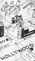 | Details | Anonymous | 1949 |
| Castles Inc. map of Hollywood and Los Angeles |
|
Anonymous |
|
| 1949 |
| LOC:3 |
| $750.00 | Anonymous | Castles-Inc--map-of-Hollywood-and-Los-Angeles | Clean, single-sided pictorial advertising map of Hollywood and the surrounding area circa 1948 published by Castle's Camera Store, 1529 Vine Street, Hollywood 28, California. Scarce. Price when issued 5 cents.
<br></br>
Castle's Camera Store operated from a small storefront across from the streamline-moderne style NBC Radio City office and studios at the corner of Sunset and Vine streets. <br></br>
<div>
<img src="/ZoomifyImages/SC_6567/Castles Camera Shop.jpg" alt="Castle's Camera Store Hollywood Storefront" width="300" align="left" style="margin: 0px 20px"/>
Karl Breneman was brother to radio personality Tom Breneman who operated Tom Breneman's restaurant from a location at 1525 North Vine Street, a few doors from brother Karl's Castle's Camera Shop.
<br></br>
Key landmarks on the map include:
<div class="indenttextblocksingle">
<ul style="list-style-type: circle;">
<li>Don Lee Mutual Broadcasting Studios (1313 North Vine Street opened August 1948)</li>
<li>Beverly Hills</li>
<li>Republic Studios</li>
<li>Grauman's Egyptian Theater</li>
<li>Hollywood Ball Park</li>
<li>a television studio</li>
<li>Earl Carrol's</li>
<li>Santa Monica, Ocean Park, and Venice piers</li>
<li>American Legion Stadium</li>
</ul>
</div> |
| 6564 | 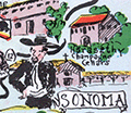 | Details | McCarty, Lea | 1955 |
| Scarce pictorial map of Sonoma County |
|
McCarty, Lea |
|
| 1955 |
| LOC:89 |
| $350.00 | McCarty--Lea | Scarce-pictorial-map-of-Sonoma-County | Fun, activity-oriented cartograph or pictorial map of Sonoma County, California by artist Lea McCarty. From a folding brochure "Fascinating Sonoma County in California's Redwood Empire Wonderland" issued in 1955 by the Sonoma County Board of Supervisors and Associated Chambers of Commerce of Sonoma Valley Inset context map withing a colorful compass rose shows Sonoma County in relationship to San Francisco and other nearby counties in California.
<br></br>
Coverage on this amusing map of Sonoma County includes portions of the surrounding counties: Napa County, Mendocino County and Marin County as well as numerous Sonoma County highlights to include:
<div class="indenttextblocksingle">
<ul style="list-style-type: circle;"></li>
<li>Bodega Bay</li>
<li>Bohemian Grove</li>
<li>Stewarts Point</li>
<li>Healdsburg</li>
<li>Digger Indian Reservation</li>
<li>Petrified Forest</li>
<li>Burbank Gardens, and</li>
<li>Petaluma</li>
</ul>
</div> |
| 6552 |  | Details | British Admiralty Hydrographical Office | 1978 |
| Admiralty Chart Baja California Sea of Cortez with Cabo San Lucas |
|
British Admiralty Hydrographical Office |
|
| 1978 |
| LOC:0 |
| $500.00 | British-Admiralty-Hydrographical-Office | Admiralty-Chart-Baja-California-Sea-of-Cortez-with-Cabo-San-Lucas | Original later issue of a British Admiralty nautical chart first engraved and published in London at the Admiralty on April 9, 1879, under the superintendence of Royal Navy Hydrographer Captain F.J. Evans and updated with corrections. Last corrected in 1978.
<br></br>
Coverage on this fine Admiralty nautical chart includes the entire Baja Peninsula and Gulf of California (Sea of Cortez) from San Diego, California to Cabo San Lucas, Mexico.
<br></br>
Numerous well-known fishing spots are noted including: San Jaime Bank, Golden Gate Bank, Outer Gorda Bank, Finger Bank, and Morgan Bank. Two inset profiles of Cabo San Lucas.
<br></br>
Bold, dark, lithographed print retains the cartographic look and style of the late 19th century. Original engraving was executed by Davies and Company. Logo of the British Hydrographical Office at top of the title block. Chart Number 2324. Crown copyright reserved. |
| 6547 |  | Details | Gist, Gilman Jr. | 1943 |
| A Soldier's Guide to Palo Alto Pictorial WWII Era Map |
|
Gist, Gilman Jr. |
|
| 1943 |
| LOC:300 |
| $1,250.00 | Gist--Gilman-Jr- | A-Soldier-s-Guide-to-Palo-Alto-Pictorial-WWII-Era-Map | <br><br>
<div class="indenttextblocksingle">
"This cartoon guide makes it as easy as "Squads Right" to find that <b>place</b> you're looking for and right here within reach of all. If you want to splurge or just "gold-brick" away an evening this will show you just what you want and how to get there."
</div>
<br><br>
Rare pictorial map of Palo Alto, California by Gilman A. Gist Jr. (d. 1960) published in a 1943 issue of the Stanford Chaparral. The Stanford Chaparral or <i>Chappie</i> is a humor magazine published by students of Stanford University since 1899, the third oldest continually published humor magazine in the world.
<br><br>
Inset maps of Menlo Park, El Camino Real, and a stretch of Bayshore Highway. Includes light-hearted images of area restaurants, clubs, theaters and other businesses that a WWII G.I. might want to visit while on leave, as well as transportation. These fine establishments include:
<div class="indenttextblocksingle">
<ul style="list-style-type: circle;"></li>
<li>Bill and Walt Collins Club</li>
<li>Fat Boy Barbecue</li>
<li>O'Neil's Stanford Bowl</li>
<li>Dinah's Shack - real suthen chicken!</li>
<li>Varsity Theater</li>
<li>Stanford Theater</li>
<li>Clarence's Smoke Shop</li>
<li>Grab-a-bite</li>
</ul>
</div> |
| 6483 |  | Details | Sandefur, John Courtney | 1954 |
| Scarce pictorial cartograph or map Monterey Bay Hotel Jeffery |
|
Sandefur, John Courtney |
|
| 1954 |
| LOC:87 |
| $150.00 | Sandefur--John-Courtney | Scarce-pictorial-cartograph-or-map-Monterey-Bay-Hotel-Jeffery | Rare folding pictorial map of the Monterey Bay Region in California by John Courtney Sandefur. Sandefur's pictograms show the obvious influence of an earlier cartograph of the Monterey Region by Ruth Taylor White.
<br><br>
The map was published by Hotel Jeffery ca. early 1950s, then conducting business in Salinas, California for over 90 years. Colorful compass rose bearing a dog's image and the motto of the Hotel Jeffery- "Friendly."
<br><br>
Verso with text about the recreational activities and resources available in the Monterey Bay Area and the Salinas Valley including Pacific Grove, Carmel, Fort Ord, Santa Cruz, and Watsonville.
<br><br>
The Jeffery Hotel in Salinas, California was opened in 1888 at the corner of Alisal and Main Streets by William "Bill" Jeffery. In the 1970’s the original three-story Jeffery Hotel was demolished.<br><br>
<div id="0" align="center">
<a title="Hotel Jeffery, Salinas, California."></a>
<img id="3" src="/ZoomifyImages/SC_6483/SC_6483_HotelJeffery.jpg" alt="Photo of Hotel Jeffery, Salinas, California circa 1960" width="300"/> <br><small>Hotel Jeffery. <i>Courtesy U. California: https://calisphere.org/</i></small>
</div><br> |
| 6480 |  | Details | Anonymous | 1986 |
| Decorative serigraph poster San Francisco Bay Golden Gate Bridge |
|
Anonymous |
|
| 1986 |
| LOC:1404 |
| $875.00 | Anonymous | Decorative-serigraph-poster-San-Francisco-Bay-Golden-Gate-Bridge | Fine decorative nautical-themed limited-edition silk-screen poster of San Francisco Bay, California and the Golden Gate Bridge from the seventh-annual users conference held by Data Design Associates in 1986. Deep rich colors. Signed within (illegible, maybe Bob Williams ?). Number 127 of 600 copies.
<br><br>
Data Design Associates, Inc., was a Sunnyvale, Calif-based developer of mainframe financial software. |
| 6481 | 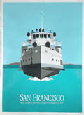 | Details | Anonymous | 1986 |
| Decorative serigraph poster City of San Francisco Ferry |
|
Anonymous |
|
| 1986 |
| LOC:1404 |
| $475.00 | Anonymous | Decorative-serigraph-poster-City-of-San-Francisco-Ferry | Fine decorative nautical-themed limited-edition silk-screen poster of San Francisco Bay, California and the ferry "City of San Francisco" from the eighth-annual users conference held by Data Design Associates in 1987. Deep rich colors. Signed within (illegible). Number 579 of 700 copies.
<br><br>
Data Design Associates, Inc., was a Sunnyvale, Calif-based developer of mainframe financial software. |
| 6482 |  | Details | Anonymous | 1986 |
| Decorative serigraph poster San Francisco Bay and Coit Tower |
|
Anonymous |
|
| 1986 |
| LOC:1404 |
| $375.00 | Anonymous | Decorative-serigraph-poster-San-Francisco-Bay-and-Coit-Tower | Fine decorative nautical-themed limited-edition silk-screen poster of San Francisco Bay, California and Coit Tower from the fifth-annual users conference held by Data Design Associates in 1984. Deep rich colors. Signed within (illegible). Number 472 of 500.
<br><br>
Data Design Associates, Inc., was a Sunnyvale, Calif-based developer of mainframe financial software. |
| 6455 |  | Details | White, Ruth Taylor | 1929 |
| Six early pictorial airline route maps by Ruth Taylor White |
|
White, Ruth Taylor |
|
| 1929 |
| LOC:14 |
| $1,200.00 | White--Ruth-Taylor | Six-early-pictorial-airline-route-maps-by-Ruth-Taylor-White | Rare and fine eleven-page brochure for Western Air Express published in 1929, just three and one-half years after the airline was founded. Includes six pictorial airline route maps or cartographs by famed illustrator Ruth Taylor White. </b> Maps with inset half-tone images of aircraft and flight operations.
<br><br>
The Western Air Express Corporation, later Western Airlines, began its first passenger service in 1926 touting speed, comfort, and dependability. By 1928, employing Fokker Super Tri-motor passenger aircraft capable of transporting twelve passengers at a blistering 125 MPH, the airline "carried about eighteen percent of all inter-city passengers in the United States." In 1928 the company initiated a seaplane route from Catalina Island, California to Los Angeles, California. Maps include:
<div class="indenttextblocksingle">
<ul style="list-style-type: circle;"></li>
<li><b>San Francisco - Los Angeles.</b> 365 miles, 3 hours. "The Worlds Model Air Line." Two facing sheets, each 7.5" x 8"</li>
<li><b>Los Angeles - Kansas City.</b> 1,417 miles - 12 hours. First and fastest all Daylight Passenger Airway." Two facing sheets each 7.5" x 8".</li>
<li><b>Los Angeles to Catalina.</b> 45 miles - 30 minutes. "Over land and sea. The first air passenger service in the United States. Single center-fold sheet 15" x 8".<br>
<b> Los Angeles to Tia Juana or Agua Caliente".</b> 116 miles - 1 hour. With above. </li>
<li><b>Los Angeles - Salt Lake City.</b> 600 miles - 6 hours. "Over the Old Mormon Trail". Two facing sheets each 7.5" x 8".</li>
<li>Map of the USA showing expected travel-time zones, indicated by color legend. No title. One half sheet.</li>
<li>B&W inset map showing location of the Western Air Express Terminal south of San Gabriel. No title.</li>
<li>Cover 8" x 9" showing all included passenger routes for Western Air Express.</li>
</ul>
</div>
Publication date noted within as October, 1929. Folds down to 4" x 9". |
| 6540 |  | Details | White, Ruth Taylor | 1929 |
| Pictorial Western Air Express route map by Ruth Taylor White |
|
White, Ruth Taylor |
|
| 1929 |
| LOC:78 |
| $135.00 | White--Ruth-Taylor | Pictorial-Western-Air-Express-route-map-by-Ruth-Taylor-White | Pictorial airline route map or cartograph by famed illustrator Ruth Taylor White for Western Air Express published in 1929, just three and one-half years after the airline was founded. Inset half-tone images of an early seaplane and of Avalon Harbor on Catalina. <br><br>
<div id="1" align="center">
<a title="Western Air Express 1929 Seaplane"></a>
<img id="1" src="/ZoomifyImages/SC_6540/SC_6540_Seaplane.jpg" alt="Western Air Express 1929 Seaplane" width="300"/> <br><small>Western Air Express 1929 Seaplane, LA to Catalina</small>
</div><br>
This map include two routes flown from Los Angeles by Western Air Express:
<div class="indenttextblocksingle">
<ul style="list-style-type: circle;"></li>
<li><b>Los Angeles to Catalina.</b> 45 miles - 30 minutes. "Over land and sea. The first air passenger service in the United States.<br>
<b> Los Angeles to Tia Juana or Agua Caliente".</b> 116 miles - 1 hour.</li>
</div>
<div id="2" align="center">
<a title="Ruth Taylor White LA to Catalina route map details"></a>
<img id="2" src="/ZoomifyImages/SC_6540/SC_6540_Detail.jpg" alt="Ruth White map details" width="300"/> <br><small>Ruth Taylor White LA to Catalina route map detail</small>
</div><br>
The Western Air Express Corporation, later Western Airlines, began its first passenger service in 1926 touting speed, comfort, and dependability. By 1928, employing Fokker Super Tri-motor passenger aircraft capable of transporting twelve passengers at a blistering 125 MPH, the airline "carried about eighteen percent of all inter-city passengers in the United States." In 1928 the company initiated a seaplane route from Catalina Island, California to Los Angeles, California. Publication date: October, 1929. |
| 6436 |  | Details | Monterey California Planning Commission | 1939 |
| 1939 Master Plan with 4 maps City of Monterey California |
|
Monterey California Planning Commission |
|
| 1939 |
| LOC:300 |
| $2,400.00 | Monterey-California-Planning-Commission | 1939-Master-Plan-with-4-maps-City-of-Monterey-California | A landmark in planning for the city of Monterey, California, an early master plan to conserve local historic buildings and landscape features. A significant feature of those conservation efforts was Emerson Knight's establishment of a Ring Route (Map D.) that “links together most of the historic houses and makes broad suggestions for street tree and vacant lot planting." [1]
<br><br>
Rare <b>Master Plan for the City of Monterey, California</b> published May 24, 1939 by the Monterey California Planning Commission. 31 pages and acknowledgements, five maps, (4 detached), more. 8 1/2" x 11". Leather-like embossed card cover, string binding.
<br><br>
Contents include text, 15 photographic images (high quality; one color), small format master plan for the City of Monterey regional sketch map. 8" x 5".
<br><br>
Back section with sleeve containing four separate detached folding maps by Emerson Knight, City Planning Advisor, in top unused condition on fine thin paper. Maps printed by Modern Printing Company, Monterey, CA:
<div class="indenttextblocksingle">
<ul style="list-style-type: circle;"></li>
<li>Map A. Conservation including protection of bay and beach frontage with proposed promenade. Emerson Knight. March 1939. 21" x 13". </li>
<li>Map B. Parks parkways and recreation showing publicly owned lands, all lands to be publicly acquired for parks, parkways, public buildings & streets also proposed promenade, bath house, and pedestrian ways. Emerson Knight. March 1939. 8" x 21". </li>
<li>Map C. Streets and highways existing traffic volumes proposed increase in traffic facilities. Emerson Knight. March 1939. 21" x 13". </li>
<li>Map D. Preservation of historic values including historic buildings and sites also showing historic ring route and proposed planting along course. Emerson Knight. March 1939. 21" x 13". </li>
</ul>
</div> |
| 6412 |  | Details | Uren, Edward Clement | 1940 |
| Mining claim map Grover Murphy Nevada City California |
|
Uren, Edward Clement |
|
| 1940 |
| LOC:10 |
| $250.00 | Uren--Edward-Clement | Mining-claim-map-Grover-Murphy-Nevada-City-California | Plat map of the Grover Murphy Claims Nevada City, California from 1940 by Edward Clement Uren M.E. (1873 - 1861). The gold claim was near Indian Flat Road about 1.8 km WNW of Nevada City.
<br><br>
At upper left the circular professional stamp of Edw. C. Uren, Registered Civil Engineer.
<br><br>
Little is known about the life of E. C. Uren. In 1912 Uren quit his job as superintendent of the Champion mine in Nevada City, CA to start a practice as a civil and mining engineer. |
| 6393 | 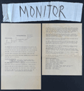 | Details | Anonymous | 1967 |
| San Francisco Protest March map, route instructions and monitors armband. |
|
Anonymous |
|
| 1967 |
| LOC:78 |
| $275.00 | Anonymous | San-Francisco-Protest-March-map--route-instructions-and-monitors-armband- | April 15, 1967 San Francisco, California protest march map, monitor instructions, and a crude cloth armband for a march monitor. Rare.
<br><br>
On April 15, 1967 amidst growing opposition to the U.S. war in Vietnam, large-scale anti-war protests were held in New York, San Francisco, and many other cities.
<br><br>
Numerous "monitor's notes" including:
<br><br>
"So far we have had good relations with the police and we would like to keep it that way".
"Above all -keep cool; <b>the armband as a symbol of authority will handle most situations by itself</b>". |
| 6428 |  | Details | Anonymous | 1949 |
| Cartoon map of UC Berkeley engineering underground radiation nuclear laboratory |
|
Anonymous |
|
| 1949 |
| LOC:300 |
| $850.00 | Anonymous | Cartoon-map-of-UC-Berkeley-engineering-underground-radiation-nuclear-laboratory | Original centerspread 1949 cartoon pictorial map, "Underground Campus", the campus of the University of California Berkeley, specifically the engineering underground tunnels and facilities including the Radiation Lab. Scientists at the UC Radiation Laboratory, now the Lawrence Berkeley National Laboratory, discovered berkelium (atomic number 97) in 1949 using a 60-inch cyclotron.
<br></br>
<div id="3" align="center">
<a title="California Engineer smoking weed?"></a>
<img id="3" src="/ZoomifyImages/SC_6428/SC_6428_SmokingWhat.jpg" alt="Early depiction of a Berkeley Engineer with roach clip." width="240"/>
</div><br>
The California Engineer began in 1903 as the California Journal of Technology. It was the first college magazine in the west to specialize in the area of science and technology. In January, 1923, after a hiatus of ten years, the magazine was revived and renamed "California Engineer" by the Student Engineers Council (1).
<br></br>
The comical map is centered around Sather Tower with a cutaway view of the subterranean network below the halls at the University of California at Berkeley. Includes Sather tunnel, Leconte Hall, Gilman Hall, Wheeler Auditorium, The Radiation Laboratory housed the research at UC Berkeley during WWII under the Manhattan Project. Note the IBM punch card machine gag at bottom left.
<br></br>
The comical map is from the January 1949 issue of <b>California Engineer</b>, the annual "Mad Issue". 36 pages. Price when issued 25 cents. Published at the University of California, Berkeley, California by the Associated Students of the University of California. |
| 6450 |  | Details | Gluck, Jay | 1948 |
| Cartoon cutaway view of UC Berkeley dormitory life |
|
Gluck, Jay |
|
| 1948 |
| LOC:1 |
| $1,000.00 | Gluck--Jay | Cartoon-cutaway-view-of-UC-Berkeley-dormitory-life | With the premiere of the IMAX biopic "Oppenheimer" (1) less than one week away (7/18/2023) we offer "Oppy's Flop House", a rare and culturally insightful 1948 cartoon cutaway elevation view of a dormitory at the University of California at Berkeley, where Oppenheimer taught physics from 1929 to 1943.
<br><br>
<div id="0" align="center">
<a title=""></a>
<img id="6450" src="/ZoomifyImages/SC_6450/SC_6450_detail_1.jpg" alt=" Rare, culturally insightful 1948 cartoon cutaway elevation view of a dormitory at the University of California at Berkeley, where Oppenheimer taught physics from 1929 to 1943." width="300"/> <br><br> <font size="-2">Oppy's Flop House- Oppenheimer Caricature Detail</font>
</div><br>
Oppy's Flop House was published in the 1948 annual "Mad Engineer" issue of "California Engineer", a student publication of the University of California at Berkeley.
<br><br>
The title "Oppy's Flop House" refers to Robert Oppenheimer [2], one of the key researchers on the Atomic Bomb that had been dropped on Japan less than three years earlier. Cartoons and sight gags include a slide rule used as a fishing device and as a guitar, chem lab equipment used to brew coffee, students using radar to peer into the room of a bathing coed, a robot, a device based on compressed air to raise the skirts of coeds, and many scenes that include engineering book gags.
<br><br>
[1] https://www.oppenheimermovie.com/<br>
[2] Physicist <strong>Robert Oppenheimer</strong> (1904-1967) was Project Director for the <strong>Manhattan Project</strong>. Oppenheimer taught at UC Berkeley from 1929 - 1943. "With the rise of the Nazi party in Germany, the University quickly became a hub for atomic weapons development. By the outbreak of World War II, Oppenheimer, his students, and several notable physicists probed atomic theory on the top floor of Le Conte Hall." |
| 5376 | 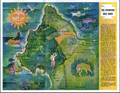 | Details | Runyan and Whitman | 1966 |
| Mid-century map of the Seventeen Mile Drive Carmel, Monterey golf |
|
Runyan and Whitman |
|
| 1966 |
| LOC:13 |
| $135.00 | Runyan-and-Whitman | Mid-century-map-of-the-Seventeen-Mile-Drive-Carmel--Monterey-golf | A perfect gift for the golfer! Fine pictorial map of the Seventeen Mile Drive snaking along Monterey Peninsula in California. Features found on this colorful map include Carmel, the Navy school in Monterey, Del Monte Shopping Center, Coast Highway No. 1, and the Pebble Beach Gun Club.
<br></br>
Verso contains descriptions of twenty-two numbered locations identified on the map including The Monterey Peninsula Country Club, Spanish Bay, Cypress Point, Crocker Grove, and the Pebble Beach Golf Links.
<br></br>
Date of the artifact is based on the fact that the brochure refers to the Spyglass Hill Golf Course as "A new 18 hole course". The Spyglass Hill course, designed by Robert Trent Jones Sr., opened in Pebble Beach during March 1966. |
| 5373 |  | Details | Board of Park Commissioners San Francisco | 1938 |
| Blueprint plan of the San Francisco Aquatic Park |
|
Board of Park Commissioners San Francisco |
|
| 1938 |
| LOC:53 |
| $1,200.00 | Board-of-Park-Commissioners-San-Francisco | Blueprint-plan-of-the-San-Francisco-Aquatic-Park | Very rare design blueprint for the San Francisco Aquatic Park. The Park lies on the north west shore of San Francisco due south of the island of Alcatraz.
<br></br>
Original blueprint (cyanotype) plan of the San Francisco Aquatic Park ca. 1938 issued by the Board of Park Commissioners for San Francisco, California. The plan features the Bath Pavilion addition, built in 1939 by the Works Projects Administration (WPA).
<br></br>
Today the Aquatic Park Historic District is a National Historic Landmark- the San Francisco Maritime National Historic Park. The Bath Pavilion is home to the San Francisco Maritime Museum.
<br></br>
WPA project no. 2175. Sheet A-0. |
| 5291 | 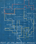 | Details | Parsons, A.F. | 1921 |
| Unrecorded cyanotype plat Beasley Ranch San Luis Obispo, California |
|
Parsons, A.F. |
|
| 1921 |
| LOC:3 |
| $475.00 | Parsons--A-F- | Unrecorded-cyanotype-plat-Beasley-Ranch-San-Luis-Obispo--California | Unrecorded cyanotype (blueprint) cadastral map of the Beasley Ranch in San Luis Obispo County, California. In 1921 the Beasley Ranch was owned by R.K. Smith. Manuscript outline coloring to differentiate the Beasley Ranch in yellow, from property owned by Eckstine in red.
<br></br>
The Beasley Ranch, at the junction of the Nacimiento River and Burnett Creek, was named for William F. Beasley, a native Californian from Mariposa County, CA. Neighboring property is recorded for Joshua Wood, Alice Lynch, Luther Hester, Sands, Harris, Wheeler, Knox, Eckstine, and others.
<br></br>
Survey of the Beasley Ranch was conducted by Austin F. Parsons in October, 1921. Parsons (b. 1853), was San Luis Obispo County Surveyor from 1902 to 1930. Parsons was the Civil Engineer for numerous area bridges including the California Canyon Bridge and San Juan Bridge.
<br></br>
Scale 1" = 40 chains ( 1/2 mile). T.25S R.8E. |
| 5260 | 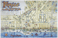 | Details | Stanton, Jeffrey | 1979 |
| Large pictorial map of Venice, California |
|
Stanton, Jeffrey |
|
| 1979 |
| LOC:53 |
| $375.00 | Stanton--Jeffrey | Large-pictorial-map-of-Venice--California | Large and amusing pictorial map of Venice, California by Jeffrey Stanton, businessman and artist. First edition.
<br></br>
Copyright 1979. Artwork by C. June Barton and R. Greenway Frager. |
| 5239 |  | Details | U.S. Army Engineers | 1878 |
| Early U.S. Flow Map Tonnage Chart of Coastwise Commerce |
|
U.S. Army Engineers |
|
| 1878 |
| LOC:3 |
| $320.00 | U-S--Army-Engineers | Early-U-S--Flow-Map-Tonnage-Chart-of-Coastwise-Commerce | Scarce thematic <b>flow map</b> of the United States west coast: California, Oregon, and Washington. An early institutional example of a "flow map" used for the U. S. Government. The flow map was first used less than 40 years earlier by Charles-Joseph Minard after his earlier formative use line width to display the attrition of French troops during Napoleon's Russian campaign of 1812.
<br></br>
<div class="indenttextblocksingle">
The chart shows the volume (tonnage) of maritime trade from all points south of San Francisco to ports along the U.S. West Coast. The use for the chart was to support the decision-making process for selecting a new harbor of refuge and breakwater on the Pacific Ocean between the Strait of Juan de Fuca and San Francisco.
<br></br>
Tonnage Chart of Coastwise Commerce North of San Francisco -California
<br></br>
From "Harbor of Refuge on the Pacific Coast Appendix PP of the Annual report to the Chief of Engineers for 1881. Washington: Government Printing Office. 1881. |
| 5039 | 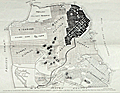 | Details | Southern Pacific Company | 1906 |
| San Francisco The Imperishable map 1906 earthquake fire |
|
Southern Pacific Company |
|
| 1906 |
| LOC:63 |
| $450.00 | Southern-Pacific-Company | San-Francisco-The-Imperishable-map-1906-earthquake-fire | Single page folding booklet about the Great San Francisco Fire and Earthquake of 1906. Scarce. With a map of the burned area by Allan Dunn and two panoramic photographs on the verso. Map size is 10" x 15". Published by Southern Pacific Company, Passenger Department.
<br></br>
One source states that the booklet was an instance of disinformation.
<div class="indenttextblock">
"Southern Pacific Railroad Co. was aggressive in its attempt to rewrite the history of the San Francisco earthquake and fire. As part of that campaign, the publicity department of the railroad churned out hundreds of articles like this to highlight the damage from fire, and minimize the effects of the earthquake; to "set the record straight," as one piece of SP literature put it."
<br></br>
"Note how his article casually dismisses the earthquake in San Francisco and surrounding communities, and stresses that the worst results from the tremor were outside the city. " (Source: Virtual Museum of the City of San Francisco. http://www.sfmuseum.org/conflag/imperish.html)
</div> |
| 5024 | 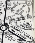 | Details | Borrego Springs Land and Development Company | 1953 |
| Scarce Borrego Springs California Sales Map |
|
Borrego Springs Land and Development Company |
|
| 1953 |
| LOC:400 |
| $550.00 | Borrego-Springs-Land-and-Development-Company | Scarce-Borrego-Springs-California-Sales-Map | Scarce tract map of lots for sale in Borrego Springs, California ca. 1953 before construction was completed on the Catholic Church. With an inset smaller-scale humorous pictorial map of the region around Borrego Springs, in San Diego County.
<br></br>
Today Borrego Springs is designated as a Dark Sky Community, the only community in California with that designation and one of only 22 locations in the world to have the designation. Not dated, not attributed. |
| 4934 | 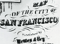 | Details | Britton and Rey | 1858 |
| Map of the City of San Francisco |
|
Britton and Rey |
|
| 1858 |
| LOC:0 |
| $2,200.00 | Britton-and-Rey | Map-of-the-City-of-San-Francisco | Fine lithographed map of San Francisco, California with red overprinted circles at 1/4 mile intervals bound into the annual report described below. Stated by another dealer as "rare" and "one of the earliest maps of San Francisco published in the city."
<br/><br/>
Only 2 sales of these rare antebellum Britton & Rey lithographed maps are recorded in AMPR, only one previous sale of the red-overprinted edition. 2nd. ed. Originally issued in 1846, but not dated within; comparison to the first edition shows no differences except for red over-printing. Neither sale included the bound report. Britton & Rey were located on Montgomery Street at the corner with Commercial Street between 1854 and 1858 (Peters, California on Stone, p. 162).
<br/><br/>
Frontispiece shows a plan, "Diagram of the Chamber of the Board of Supervisors, 1863. H.P. Coon, President
<br/><br/>
The gilt-edged report into which the map is bound: " San Francisco Municipal Reports for the Fiscal Year 1862-'63" published at the orders of the Board of Supervisors. San Francisco: Printed at Charles F. Robbins & Company. No 417 Clay Street, between Sansome and Battery. 1863. Contains reports from City Auditors, City Surveyor and other department heads and city officials. 6" W x 9" H. Binding tight. Original covers with binders identification inside the front cover at top left: Bartling & Kimball, Binders, 505 Clay Street, San Francisco.
<br/><br/>
Spine (poor with 1" missing) reads: Municipal Reports, San Francisco 1862-663. Cover (good) reads: "Presented by the City of San Francisco." |
| 4925 | 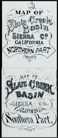 | Details | U.S. Geological Survey | 1873 |
| Pair of mining maps for Slate Creek Basin, California |
|
U.S. Geological Survey |
|
| 1873 |
| LOC:13 |
| $270.00 | U-S--Geological-Survey | Pair-of-mining-maps-for-Slate-Creek-Basin--California | Two rare original antique mining maps of the northern and southern part of Slate Creek Basin in Sierra County California. Both maps show placer mine (stream-bed mining) locations with company names, Chinese mining camps, tunnel locations, hydraulic mines, dwelling houses, waterways and proposed tunnels.
<br /><br />
Shows many ditches and labeled wagon roads including the "wagon road from La Port to Queen City."
<br /><br />
Mining companies include Yankee Hill Placer Mines, Maria Hartman Company, Alturas Gold Mining Company, Indian Queen Company, and Poverty Point Placer Mines. |
| 4927 |  | Details | U.S. Coast and Geodetic Survey | 1880 |
| Scarce antique Chart of Monterey Harbor California |
|
U.S. Coast and Geodetic Survey |
|
| 1880 |
| LOC:63 |
| $750.00 | U-S--Coast-and-Geodetic-Survey | Scarce-antique-Chart-of-Monterey-Harbor-California | Electrotype copy of the chart of Monterey Harbor with a fine engraved coastal elevation view of Point Pinos from 5 miles seaward. Includes sailing directions. Chart number 5491. First issued 1852 but ca. 1880.
<br></br>
This is a scarce, separately issued, rolled hydrographic chart of the California coast, first published in 1852, not one of the common folded versions on thin paper that were issued with other charts in an annual report to Congress from the Coast Survey.
<br></br>
This antique chart was printed from an electrotype copy of the original hand-engraved copper plate, a process the U.S. Coast Survey adopted around 1850. As a soft medium, copper plates could only withstand print runs of perhaps 200 copies before the plates wore down. To enable larger print runs, a mold of the original plate was created in wax or another soft medium. Then, using an electro-chemical process ( electrotyping ), the mold was coated with a metal layer, typically copper. Printers were then able to produce output from the new electrotype copper copy, while preserving the original.
<br></br>
Electrotype copy no. 3. Sheet size 27"x24". Logo of the Coast Survey Office. Price when issued 15 cents. |
| 4902 |  | Details | Monticello Steamship Company | 1907 |
| Antique Birdseye View of San Francisco and Napa Valley Monticello Steamship Company |
|
Monticello Steamship Company |
|
| 1907 |
| LOC:41 |
| $350.00 | Monticello-Steamship-Company | Antique-Birdseye-View-of-San-Francisco-and-Napa-Valley-Monticello-Steamship-Company | A shaded relief promotional map illustrating the Bay of San Francisco and Napa Valley, emphasizing overland routes and steamship connections operated by the Monticello Steamship Co., linking San Francisco with Vallejo and the Napa River corridor. Scarce with this view.
<br></br>
Copyright 1907 by Monticello Steamship Company.
<br></br>
With steamship routes and electric railroad routes to and through:
Vallejo
The U.S. Navy Yard
Mare Island
Napa Valley Route
<br></br>
Card cover and four inner pages. With Information on fares, steamship and electric Railroad Routes
Size closed: 4" x 9 1/2". By Sierra Art and Engineering Co. S.E. |
| 4861 |  | Details | Edwards, Ham | 1929 |
| Antique Map Catalina Island, California Depression-era |
|
Edwards, Ham |
|
| 1929 |
| LOC:13 |
| $150.00 | Edwards--Ham | Antique-Map-Catalina-Island--California-Depression-era | Fine pre-depression-era brochure with a bright pictorial map of Catalina Island in the Pacific Ocean, off the coast of Long Beach, California. Published by Wilmington Transportation Company who offered steamer services from the Catalina Steamer Terminal to Catalina Island from Los Angeles, Long Beach, and Pasadena.
<br></br>
Included in a six-page brochure with things to do, rates for trips and ferry service, photographs, and advertisements for local hotels including the "Largest one floor hotel in the world with 1250 rooms." Map predates the Great Crash of October 1929 by three months.
<br></br>
Drawn by "Ham" Edwards - Art Services. |
| 4819 |  | Details | Market Street Railway Company | 1925 |
| San Francisco Streetcar Blueprint |
|
Market Street Railway Company |
|
| 1925 |
| LOC:62 |
| $375.00 | Market-Street-Railway-Company | San-Francisco-Streetcar-Blueprint | An original, authentic blueprint diagram from 1925 for a <b>Market Street Railway Company</b> "double-truck" (2 sets of wheels) streetcar. San Francisco, California. Scarce. The blueprint still carries the manuscript engineering index number, 907, in red crayon, that would have been used to uniquely identify the blueprint and to tie it to a set of specifications.
<br></br>
Title reads: "Market Street Railway Company. M.M. Department. Body Design & Seating Arrangement of Cars 266-285, 286-305, 779-808. Drawing number M.M. 3005. 8/24/25." Overall length including bumpers was 47'.
<br></br>
<figure>
<img src="/ZoomifyImages/SC_4819/Market_Street_Railway_Co_car_285.jpg" alt="Market Street Railway Company 47' streetcar number 285)" width="300" align="left" style="margin: 0px 20px">
<figcaption>
<div style="text-align:center;font-size: 80%">Streetcar number 285.</div>
</figcaption>
</figure>
<br></br>
The Market Street Railway Company began operating on July 4, 1860 with a steam railway. After a series of mergers and sales, the company was acquired by Standard Gas & Power Company in late 1925.
<br></br>
Source: Vielbaum, Hoffman, Ute, Townley. San Francisco's Market Street Railway. Charleston. Arcadia Pub. 2004. |
| 4818 | 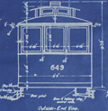 | Details | Market Street Railway Company | 1925 |
| Fillmore Hill "Dinky" Streetcar Blueprint |
|
Market Street Railway Company |
|
| 1925 |
| LOC:62 |
| $600.00 | Market-Street-Railway-Company | Fillmore-Hill-"Dinky"-Streetcar-Blueprint | Rare find! An original, authentic blueprint diagram from 1925 for a <b>Market Street Railway Company streetcar</b>. That is a San Francisco, Ca. streetcar, number 649!
<br></br>
The blueprint still carries the MS index number, 755, in red crayon, that would have been used to uniquely identify the blueprint and to tie it to a set of specifications. This type of streetcar was known to have a rough ride because unlike larger cars, "single-truck" streetcars had only one set of four wheels.
<br></br>
Rectangular purple ink stamp on verso for "Market Street Railway Company | Aug 29, 1925 | Blue Print Room". Number M.M. 3013.
<br></br>
Title reads: "Market Street Railway Company. M.M. Department. Body Dimensions of Fillmore Hill Cars after Reconstruction. Overall length 26' 3.5". <br> Overall Width 8' 0" ". 8/24/25.
<br></br>
<img src="/ZoomifyImages/SC_4818/MarketStreetCar621.jpg" alt="Market Street Railway Co. "Dinky" Fillmore Hill streetcar.")" width="300" align="left" style="margin: 0px 20px"> </img>
<br />
<br />
Some of the literature refers to this 26 foot long diminutively-sized street-car as a "Dinky". In its general dimensions and rolling equipment, our blueprint is very similar to car 578, built in 1896, one of the first generation of San Francisco's electric streetcars. Today, number 578 is stated to be the, "world’s oldest streetcar still on the active roster of an urban transit agency."
<br></br>
The Market Street Railway Company began on July 4, 1860 with a steam railway. After a series of mergers and sales, the company was acquired by Standard Gas & Power Company in late 1925.
<br></br>
Sources:
https://www.kalw.org/post/how-muni-s-oldest-streetcar-survived-122-years-become-san-francisco-s-sweetheart#stream/0
<BR/>
Vielbaum, Hoffman, Ute, Townley. San Francisco's Market Street Railway. Charleston. Arcadia Pub. 2004. |
| 4799 |  | Details | Glantz, Dale A. | 1985 |
| Bathymetry and landmarks La Jolla, San Diego, California |
|
Glantz, Dale A. |
|
| 1985 |
| LOC:63 |
| $375.00 | Glantz--Dale-A- | Bathymetry-and-landmarks-La-Jolla--San-Diego--California | Original privately-published chart of the La Jolla coast. The most easily attainable chart of La Jolla, California from 1985 to combine bathymetry data from the U.S. Coast and Geodetic Survey with pictorial images of the landmarks and data regarding coverage of the kelp beds offshore. Designed, printed, and copyrighted 1985 by Dale A. Glanz d.b.a. Daleʾs Ink. Detailed countour intervals of one fathom (six feet). No copies in AMPR or online; limited institutional holding.
<br></br>
From 1978 to 2005 Dale Glanz is reported to have been employed by Kelco (now ISP Alginates) as Operations Manager/Senior Marine Biologist. Kelco began near San Diego in the late 1920s, harvesting brown seaweed, or kelp, and extracting the algin that is used in countless pharmaceutical, household and food products.
<br></br>
Shows notable landmarks that could be used to relate one's position to the bathymetry on the chart. Landmarks include a "copper roof mansion", the La Jolla Shores Lifeguard Station, the Summer House Inn, Seville Condominium, Sea World Tower, and Islandia House. Beaches shown include Ocean Beach, Mission Beach, Pacific Beach, Casa Beach, Windandsea Beach. Other noted features include Seal Rock, The Cove, Kellogg Park, Whale View Point, La Jolla Hermosa Park, and the Crystal Pier.
<br></br>
Shows the La Jolla Canyon and the Scripps Canyon that terminate just offshore of the Scripps Institute of Oceanography. Shading denotes areas with an overlaying canopy of kelp. |
| 4790 | 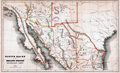 | Details | Bancroft, Hubert Howe | 1883 |
| Native races of the Pacific states New Mexican group |
|
Bancroft, Hubert Howe |
|
| 1883 |
| LOC:77 |
| $70.00 | Bancroft--Hubert-Howe | Native-races-of-the-Pacific-states-New-Mexican-group | Shows the names and lands of the Native American Indians. Covers the full extent of the Baja California peninsula, the Sea of Cortez, parts of Texas, Mexico, Arizona and New Mexico. Places Cape (Cabo) San Lucas at the tip of the Baja peninsula. Native tribes placed in their geographical context include the Guanicuris, Cochimis, Yuma, Papago, Comanche, Zuni, Navajo and many more.
<br></br>
From Bancroft's "The Native Races of the Pacific States of North America." Includes land formations, political boundaries, and rivers. |
| 3693 |  | Details | Hunter, T.B. | 1909 |
| Large antique blueprinted map of Pebble Beach, California |
|
Hunter, T.B. |
|
| 1909 |
| LOC:1408 |
| $1,800.00 | Hunter--T-B- | Large-antique-blueprinted-map-of-Pebble-Beach--California | Fine large rolled 5' original antique cyanotype (blueprint) map (20 sq. ft.) of Pebble Beach, CA made in 1909, almost ten years before the opening of the famed Pebble Beach golf course. The earliest reasonably obtainable and the largest cyanotype cadastral map of Pebble Beach, CA.
<br></br>
Ironically, on this map the area now partly occupied by the golf course is marked "Reserved for Public Use". Pebble Beach Lodge is shown centered within Lot 123, a parcel of 9.487 acres. Locations that are shown but not named include Arrowhead Point, Pescadero Canyon, and Stillwater Cove.
<br></br>
Data for each lot include the lot number, metes and bounds (bearing and length of all lines bisecting each physical property marker stake), and acreage.
<br></br>
Includes Seventeen-Mile Drive and Carmel Bay. Monterey County. Shows topography with contour intervals of 10 feet.
<br></br>
Surveyed by T.B. Hunter, C.E. and drawn by T.F. Rogers.
<br></br>
North is oriented to upper right.
<br></br>
(Note: Yellow straight-edge rules shown are 48" long.) |
| 3680 | 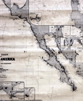 | Details | James Imray and Son | 1876 |
| West Coast of North America from San Blas to San Francisco |
|
James Imray and Son |
|
| 1876 |
| LOC:0 |
| $2,400.00 | James-Imray-and-Son | West-Coast-of-North-America-from-San-Blas-to-San-Francisco | Spectacular and large blueback nautical chart from <b>California's post Gold-Rush era</b> . Published five years before the establishment of the San Francisco Stock Exchange at 312 California Street, this antique sea-faring chart documents all the ports, harbors, and towns along the west coast of North America from Mendocino City, CA. to past Cabo Corrientes, Mexico and includes the Baja Peninsula with full coverage of all the areas surrounding <b>Cabo San Lucas</b> and <b>Mazatlan</b>, MX.
<br></br>
This blueback chart contains numerous inset charts including: San Francisco Bay; Santa Barbara; Bodega Bay; San Diego Bay; Ballena Bay; Mangles Road; San Jose del Cabo Bay; Tamales Bay; Magdalena Bay; San Lucas Bay; Mazatlan.
<br></br>
Verso consists of the original blue-paper backing as issued to strengthen the chart for its expected hard life at sea. Also on the verso is the original yellow publisher's label from the Imray firm that reads "COAST OF CALIFORNIA. James Imray and Son. London. Chart 135."
<br></br>
Due to changing conditions charts could become outdated quickly and it was important for mariners to understand the accuracy of their navigational charts. The British Admiralty and later the U.S. Coast Survey responded by recording the dates of each update on the map, in some cases maintaining a historical record of updates spanning many decades. Private publishers of sea charts fulfilled the same need by providing the date of the last update with an inked over stamp. |
| 3667 | 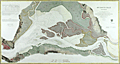 | Details | U.S. Coast and Geodetic Survey | 1867 |
| Fine antique chart of Suisun Bay, California |
|
U.S. Coast and Geodetic Survey |
|
| 1867 |
| LOC:63 |
| $800.00 | U-S--Coast-and-Geodetic-Survey | Fine-antique-chart-of-Suisun-Bay--California | Very attractive scarce antique engraved chart of Suisun Bay, California northwest of San Francisco Bay. Key features include Grizzly Island, Van Sickle's Island, Chipp's Island, Sherman Island, the Carquines Straits, and the towns of Antioch, Benicia and Martinez.
<br></br>
Rare U.S. Coast Survey separately published chart of Suisun Bay, California. For the collector of California cartography, a very special chart of Suisun Bay which lies at the confluence of the Sacramento and San Joaquin Rivers, forming the entrance to the Sacramento–San Joaquin River Delta. Dated within to 1867. With fine detail of interior topography. Assumed to be the first edition.
<br></br>
The map covers from Benicia and the Karquines Strait in the west as far as Sherman Island in the east and from Grizzly Island south to the San Joaquin River. Includes countless depth soundings in feet, detailed notes on tides. Several towns and cities are identified, including Martinez, Benicia, and Collinsville.
<br></br>
This plate is not from the common 1867 Report of the Superintendent of the United States Coast Survey. The chart is an original copper-plate engraved chart 32" x 17" on a huge sheet of crisp surveyor's paper 30" x 40". Not an electrotype copy. This engraving was printed from the original hand-engraved copper plate. Evidence of a wide platemark. Price 75 cents when issued.
<br></br>
This chart of Suisun Bay is unlike most Coast Survey charts we have handled. It is on crisp oversize paper and has not been folded into a Coast Survey atlas (nor was it printed for that purpose). The chart does not carry the caveat at upper right "Electrotype Copy No. X". Based on that as well as by the markings on this chart and other items purchased in the same sales lot we feel there is a high probability that the chart was a surplus proof and or reference file copy of the U.S.G.S. |
| 3668 | 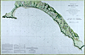 | Details | U.S. Coast and Geodetic Survey | 1860 |
| Fine antique chart of Drake's Bay, California |
|
U.S. Coast and Geodetic Survey |
|
| 1860 |
| LOC:63 |
| $650.00 | U-S--Coast-and-Geodetic-Survey | Fine-antique-chart-of-Drake-s--Bay--California | Very attractive scarce antique engraved chart of Drake's Bay, California on the Pacific Ocean just northwest of San Francisco. Coverage extends southward as far as Duxbury Reef. Includes sailing directions, notes on dangers, soundings and abbreviations, and tide table.
<br><br/>
A surviving survey file copy from the U.S. Geological Survey Library. With an oval faded ink stamp from that agency. Map number in MS at bottom corners as typical for surveyor's file copies.
<br><br/>
Now a part of Point Reyes National Seashore, the area covered by this old chart includes detailed topographical information and is generally devoid of named features. "Breakers" are noted in numerous areas all along the beaches. Numerous depth soundings.
<br><br/>
This antique chart should not be confused with those similar copies that were issued with dozens of others as part of a Report to Congress, most on thin paper with folds that often show condition issues. This original mid 19th century survivor is a large, separately issued example on crisp, strong paper that has been stored rolled with a NO FOLDS. Price 20 cents. NO logo of the Coast Survey Office. Number 629. |
| 3663 | 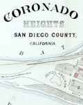 | Details | Anonymous | 1891 |
| Antique lot plan of Coronado Heights in San Diego County |
|
Anonymous |
|
| 1891 |
| LOC:88 |
| $210.00 | Anonymous | Antique-lot-plan-of-Coronado-Heights-in-San-Diego-County | Plat map of Coronado Heights Subdivision in San Diego County, California produced a year after Coronado residents voted to incorporate. Shows the grounds for the Hotel de Coronado, completed in 1888, at that time the largest resort hotel in the world.
<br></br>
Includes a boulevard to Coronado Beach as well as the tracks for the Coronado Railway, a street railway system to carry a 50-seat excursion car and steam locomotive. With notes indicating the size of blocks and street width. |
| 3651 | 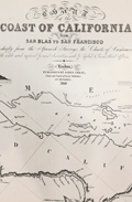 | Details | Imray, James | 1849 |
| Fine gold-rush era blueback chart of California |
|
Imray, James |
|
| 1849 |
| LOC:1409 |
| $3,900.00 | Imray--James | Fine-gold-rush-era-blueback-chart-of-California | California gold-rush era blueback chart of the West Coast from the harbor of San Blas in Mexico heading north past San Francisco Bay. Coverage includes the Gulf of California and the Baja Peninsula. A wide nautical chart in landscape orientation.
<br></br>
Includes six insets and eight stunning coastal views. The insets include: "Entrance of San Francisco Harbour"; "Harbour of San Francisco By Capn. F.W. Beechey R.N. F.R.S."; and "Bay of Monterey By M. de Tessan of the French Navy." Also, Magdalen Bay, Mazatlan, and Guaymas.
<br></br>
Published by James Imray, Chart and Nautical Book Publisher 102, Minories. 1849.
<br></br>
During the 1800's there was a trend toward publication of very large small-scale charts with large-scale insets of key passages and harbors. The practice was driven as much by economics as any other reason. One chart could replace a dozen smaller charts. James Imray and Son was one of a handful of British publishers who specialized in these charts which were often backed with canvas or linen cloth or heavy blue paper in order to help them withstand the frequent use and abuse aboard ship, hence the term "blueback chart". |
| 3627 | 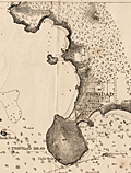 | Details | U.S. Coast and Geodetic Survey | 1873 |
| Antique Chart of Trinidad Harbor, California Humboldt County |
|
U.S. Coast and Geodetic Survey |
|
| 1873 |
| LOC:10 |
| $200.00 | U-S--Coast-and-Geodetic-Survey | Antique-Chart-of-Trinidad-Harbor--California-Humboldt-County | Rare harbor chart of Trinidad Harbor, in Humboldt County, California. With an attractive coastal elevation view of Trinidad Head, Prisoner's Rock and the entrance to the harbor as seen from offshore. Contains sailing directions, tide tables, notes and more. We are unable to find this item online or on AMPR!
<br></br>
Manuscript notations and ink stamp by the U.S. Geological Survey are unusual and point to the authenticity and age of this chart. |
| 3623 |  | Details | Ringgold, Cadwalader | 1850 |
| Antique Chart of the Entrance to San Francisco Bay |
|
Ringgold, Cadwalader |
|
| 1850 |
| LOC:63 |
| $1,100.00 | Ringgold--Cadwalader | Antique-Chart-of-the-Entrance-to-San-Francisco-Bay | Cadwalader Ringgold's detailed, chart of the approach and entrance at San Francisco Bay, California from 1850. Includes Yerba Buena island, Alcatraces (Alcatraz Island), Sausalito Bay, Aspinwall Bay, and much more. Attractive elevation profile view of a square rigged sailing vessel set against a backdrop of the coastline at San Francisco. Constructed, projected and drawn by Fred D. Stuart.
<br ></br>
Ringgold (1802-1867) was a officer in the U.S. Navy who had served aboard the brig Porpoise with the U.S. Exploring Expedition during Wilkes' surveys of the area in 1841 . Ringgold was promoted to Commander in July, 1849 and began his groundbreaking survey of the San Francisco Bay region, suddenly important because of the discovery of gold in the area. The survey began in August 1849, with Ringgold commanding the chartered brig Col. Fremont. Peter Guthorn notes Ringgold's use of Beechy's earlier survey in his charts:
<div class="indenttextblock">"Ringgold's charts and sailing directions employed material extracted from the account by Fredrick William Beechy, the British explorer and naval officer whose narrative of the voyage to the Pacific and Behring Sea was published in 1831." (Guthorn, Peter. "U.S. Coastal Charts 1783-1861." Schiffer Publishing. 1984. p. 195)</div> |
| 3619 | 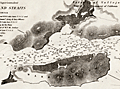 | Details | U.S. Coast and Geodetic Survey | 1851 |
| Early U.S. Coast Survey Chart of Mare Island Vallejo California |
|
U.S. Coast and Geodetic Survey |
|
| 1851 |
| LOC:3 |
| $85.00 | U-S--Coast-and-Geodetic-Survey | Early-U-S--Coast-Survey-Chart-of-Mare-Island-Vallejo-California | Antique U.S. Coast Survey chart of the Mare Island Strait. Includes Mare Island and Vallejo, California. Topographic detail is rendered through elegant and informative hachuring. Scale 1 / 30,000. |
| 3616 | 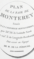 | Details | La Perouse, Jean François Galaup | 1797 |
| Earliest obtainable map of the Monterey and Carmel, California region. |
|
La Perouse, Jean François Galaup |
|
| 1797 |
| LOC:10 |
| $550.00 | La-Perouse--Jean-François-Galaup | Earliest-obtainable-map-of-the-Monterey-and-Carmel--California-region- | The first French edition of the antique early plan of Monterey Bay, Carmel, and Carmel Bay in California is an uncolored and historically significant chart. It is the only chart of La Pérouse's based on his own exploration, making it a foundational map for collectors of 18th-century California cartography. This chart represents the earliest obtainable map of the Monterey and Carmel region.
<br><br>
The hand-colored chart accurately portrays the small town of Carmel, featuring the Mission de St. Charles and the Presidio at a distance. The map provides insight into how the area's geography impacted the development of local transportation routes. It locates an anchorage (mouillage), Pointe du Nouvel-an (New Year Point near Santa Cruz), and the Montagnes de St. Lucie. The bay's rhumb lines are oriented with north to the left, adding to the rarity of the map.
<br><br>
This map is part of the French edition of the "Atlas du voyage de La Perouse," with L. Aubert as the engraver. It appears as Plate 34 within the atlas. Collectors and historians alike treasure this map as a crucial piece of 18th-century California cartography and a testament to La Pérouse's exploration of the Pacific. |
| 3583 | 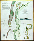 | Details | U.S. Coast and Geodetic Survey | 1867 |
| Humboldt Bay, California |
|
U.S. Coast and Geodetic Survey |
|
| 1867 |
| LOC:63 |
| $475.00 | U-S--Coast-and-Geodetic-Survey | Humboldt-Bay--California | Rare and extremely attractive U.S. Coast Survey separately-published chart of Humboldt Bay, California. For the collector of California cartography, a very special chart of Humboldt Bay which lies on the Pacific Coast of California just below the town of Eureka, CA. With a elevation profile view of Red Bluff Entrance to Humboldt Bay as it then appeared from 2 1/2 miles offshore and a small-scale chart of the entire Humboldt Bay environs. Second edition. Dated 1852 but probably printed around 1867. MS chart number in margin "632".
<br></br>
Towns shown include Humboldt, Eureka and Bucksport. Other features include the site of a proposed lighthouse and a beacon, Elk River, Indian Island, and Howard House in Humboldt.
<br></br>
This plate is not from the common 1867 Report of the Superintendent of the United States Coast Survey. The chart is an original copper-plate engraved chart 14" x 17" on a huge sheet of crisp surveyor's paper 20" x 26". Not an electrotype copy. This engraving was printed from the original hand-engraved copper plate. Evidence of a wide platemark. Price when issued 15 cents.
<br></br>
This chart of Humboldt Bay is unlike most Coast Survey charts we have handled. It is on crisp oversize paper and has not been folded into a Coast Survey atlas (nor was it printed for that purpose). The chart does not carry the caveat at upper right "Electrotype Copy No. X". Based on that as well as by the markings on this chart and other items purchased in the same sales lot we feel there is a high probability that the chart was a surplus proof and or reference file copy of the U.S.G.S. |
| 3578 | 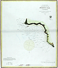 | Details | U.S. Coast and Geodetic Survey | 1867 |
| Point Sal, California |
|
U.S. Coast and Geodetic Survey |
|
| 1867 |
| LOC:63 |
| $375.00 | U-S--Coast-and-Geodetic-Survey | Point-Sal--California | Rare U.S. Coast Survey chart of Point Sal, California. For the collector of California cartography, a special chart of Point Sal which lies on California's Pacific Coast somewhat midway between Santa Barbara and San Luis Obispo. Original copper-plate engraved chart 14" x 17" on a huge sheet of crisp surveyor's paper in total 20" x 26". Assumed to be the first edition.
<br></br>
Not an electrotype copy. This engraving was printed from the original hand-engraved copper plate. Evidence of a wide platemark. Price 15 cents when issued.
<br></br>
This chart of Point Sal is unlike most Coast Survey charts we have handled. It is on quality oversize paper and has not been folded into a Coast Survey atlas (nor was it printed for that purpose). The chart does not carrry the caveat at upper right "Electrotype Copy No. X". Based on that as well as by the markings on other items purchased in the same sales lot we feel there is a high probability that the chart was a surplus proof and or reference file copy of the U.S.G.S. The date appears at bottom left along with the map number "660", both to facilitate searching a the files. Chart no. 660. |
| 2521 | 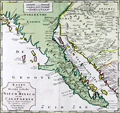 | Details | Tirion, Isaac | 1765 |
| Fine 18th century map of Lower California, Arizona and Mexico |
|
Tirion, Isaac |
|
| 1765 |
| LOC:10 |
| $750.00 | Tirion--Isaac | Fine-18th-century-map-of-Lower-California--Arizona-and-Mexico | Isaac Tirions's map of the American Southwest reflects the recent explorations of the Jesuit Fathers and others. Named locations include Casa Grande and San Xavier de Bac in the Southwest. Along the Pacific Ocean are noted San Diego, Ensenada and Cabo San Lucas. Numerous, oversized islands are shown along both coasts of the Baja California Peninsula.
<br></br>
Missions are pictorially identified throughout the map and there are two fortifications in Baja at San Jose del Cabo and Loretto.
<br></br>
Isaak Tirion, (1705 - 1765) was a Dutch publisher who produced several atlases and Dutch town plans from the Kalverstraat, in Amsterdam. Tirion produced a total of eight atlases in multiple editions |
| 2499 | 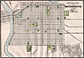 | Details | Cram, George F. | 1898 |
| Antique Sacramento, California steet map |
|
Cram, George F. |
|
| 1898 |
| LOC:3 |
| $60.00 | Cram--George-F- | Antique-Sacramento--California-steet-map | An interesting and detailed late 19th-century map of Sacramento, California. This map of Sacramento shows the major streets, rivers, parks, cemeteries, railroads and more. Named points of interest include Lake Sutter, the Old Channel, Agriculture Park, Capitol Park, East Park, City Cemetery, Catholic Cemetery, Helvetia Cemetery, and Snowflake Park. Most of the city east of 32nd street and north of Y Avenue was undeveloped at that time.
<br></br>
From Cram's 1898 Universal Atlas - Geographical, Astronomical and Historical. |
| 1418 | 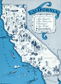 | Details | Johst, Paul Spener | 1931 |
| California Pictorial Map |
|
Johst, Paul Spener |
|
| 1931 |
| LOC:20 |
| $85.00 | Johst--Paul-Spener | California-Pictorial-Map | Pictorial map of the State of California in a cartoon-like style. Depicts transportation, chief industries (film-making, asparagus farming), nature, and recreations for the state in an exaggerated, stereotyped manner. Legend identifies 5 locations within California: Yosemite National Park, San Francissco, Oakland, Los Angeles, and San Diego. Catalina Island is identified by name. Page 181.
<br></br>
Verso with text extolling the virtues of California's natural wonders and its agriculture.
<br></br>
From "Picture Map Geography of the United States" by Vernon Quinn. With Picture Maps by Paul Spener Johst. Publisher: Frederick A. Stokes Company. New York. 1931. Some picture maps in the book contain depictions that today might be considered politically incorrect or even racist. |
| 1361 | 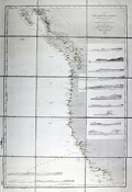 | Details | Depot de la Marine | 1886 |
| Antique chart of the United States West Coast |
|
Depot de la Marine |
|
| 1886 |
| LOC:2001 |
| $550.00 | Depot-de-la-Marine | Antique-chart-of-the-United-States-West-Coast | Large folding nautical chart of the West Coast of the United States from past San Diego, California in the South to Queen Charlotte Sound and Moresby Island in British Columbia, Canada. Published by France's Depot de la Marine in 1862 but this edition with essential corrections dates to 1886.
<br></br>
With owners overstamps from the Library of Canadian Energy, Mines, and Resources Department in 1969 and 1976. Chart Number 1979. |
| 1338 | 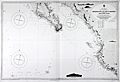 | Details | British Admiralty Hydrographical Office | 1926 |
| Chart of Lower Baja California, Cabo San Lucas, to Manzanilla Bay |
|
British Admiralty Hydrographical Office |
|
| 1926 |
| LOC:0 |
| $525.00 | British-Admiralty-Hydrographical-Office | Chart-of-Lower-Baja-California--Cabo-San-Lucas--to-Manzanilla-Bay | Amazing, clean, authentic British nautical chart of lower Baja Peninsula and west coastal Mexico with Sinaloa, Jalisco and the Sea of Cortez. Heading southward this popular and highly attractive chart covers from San Ignaciao Bay to Manzanillo Bay. This large chart will make a very attractive, unusual, and affordable gift for anyone with an interest in fishing or boating in the vicinity of Baja California. Thousands of depth soundings and numerous well-known fishing spots are noted including: San Jaime Bank, Golden Gate Bank, Outer Gorda Bank, Finger Bank, and Morgan Bank. Two inset profile views at top of the Baja Californa coast as seen from offshore near Las Animas.
<br></br>
Later edition of a British Admiralty chart first engraved and published from London in 1879; this edition to 1916 and the last corrections made in 1926. Coverage includes the lower Baja California Peninsula and Gulf of California (Sea of Cortez) from Las Animas to Cabo San Lucas, Mexico, Mazatlan, Cape Corrientes, and on to Manzanillo Bay. Contains detailed names of the numerous rivers, lights, capes, and bays surrounding the Baja Peninsula. Includes the Revillagigedo Archipelago.
<br></br>
Bold dark lithographed print retains the cartographic look and style of the late 19th century. More recent charts do not display the character of this beauty. Logo of the British Hydrographical Office at top of the title block. Originally published from London on April 9, 1879 but the edition of 1916 with corrections to 1926. Number 2323. |
| 1120 | 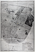 | Details | Bull, W.H. | 1911 |
| Antique Birdseye View Map of San Francisco |
|
Bull, W.H. |
|
| 1911 |
| LOC:41 |
| $675.00 | Bull--W-H- | Antique-Birdseye-View-Map-of-San-Francisco | Scarce large antique map or bird's-eye view of San Francisco, California showing the street layout as it existed in 1911. A search of the Internet finds no map with by Bulland title. Suggest you verify.
<br></br>
Key at bottom lists 31 points of interest including the Union Ferry Depot, the Southern Pacific Depot, St. Francis Hotel, Mission Dolores and locations of nine churches. Other labeled features include the Presidio, Fort Miley Park, Golden Gate Park, Buena Vista Park, Twin Peaks, Cliff House, and Telegraph Hill. Ferry routes are shown from the Union Ferry Depot to numerous points including Sacramento, Alameda, Oakland, and Berkeley, California.
<br></br>
Published after the great earthquake and subsequent fire of 1906 the map was issued by the California General Committee of the 13th International Sunday School Convention (June 20-27, 1911) to registrants at the convention. Verso contains photos and descriptions of regional points of interest.
<br></br>
San Francisco commercial artist William Howell Bull (1861-1940) was a Bull’s colorful illustrations graced the pages of books and magazines of the early 1900s. His work can also be found in the pages of the University of California yearbook, the Blue and Gold via Anthony Bruce and Facebook.
<br></br>
Bull moved to California from New York in the late 1800s. In 1893, Bull organized a trip with three other men to explore and sketch the south fork of Kings River. In 1901, Bull became a resident of San Mateo where he lived for the rest of his life and a year later co-founded the California Society of Artists as an alternative to the earlier established San Francisco Art Association. Around 1915, he worked as a commercial artist for the Southern Pacific Railroad, and also provided illustrations to Pacific Electric, Sunset magazine, and Stanford University. Bull’s rare landscape paintings typically feature scenic areas in Northern California. |
| 1090 | 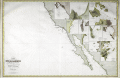 | Details | Robiquet, Aime | 1856 |
| Rare Antique French Chart of the California Coast and Baja Peninsula |
|
Robiquet, Aime |
|
| 1856 |
| LOC:68 |
| $3,000.00 | Robiquet--Aime | Rare-Antique-French-Chart-of-the-California-Coast-and-Baja-Peninsula | Very rare engraved chart of the California coast from Shelter Cove south to Mazatlan, Mexico: "Carte des Côtes de Californie de Mazatlan à San Francisco d'Après les derniers Travaux Amércains Par Robiquet, Hydrographe Rue Pavée Saint Andre No.2. Paris 1856". This large chart is particularly interesting for its collection of numerous inset plans of North American West Coast ports and bays during the late California Gold Rush.
<br></br>
Coverage includes the <b>Baja Peninsula</b> or "Vieille Californie" with Cabo San Lucas ("Cap St. Lucas") at the end. Contains inset plans of the bays and ports at Guaymas, Ballena, St. Bartholomé, Pulpito, San Quentin, San Diego, San Pedro, Monterey, San Francisco, and Bodega Bay.
<br></br>
Scarce and detailed map of California's coastline, with much detail for navigation and a few inland landmarks. Printed in Paris by French hydrographer and publisher Louis Antoine Robiquet. Presumably from Robiquet's "Atlas Hydrographique" of 1856, but this printing with separate price (4 francs) and publisher's blind stamp in bottom right margin. Only one institutional copy is recorded in WorldCat.
<br></br>
Inset plans include: (1): Baie Bodega Levé en 1839 par Ed. Belcher. (2): Plan de la Baie de Monterey Levé en 1837 par Mr. De Tessan, Ingr. Geographe. (3): Entrée du Port de San Francisco par Cadwalader Ringgold. (4): San Pedro par James Alden 1852. (5): Entrée de San Diego par R.D. Cutts et G. Davidson. (6): Port San Quentin Levé in 1839 par Ed. Belcher. (7): Port St. Bartholomé Levé par le Cape. H. Kellet en 1847. (8): Mouillage Pulpito par le Cape. H. Kellet. (9): Port Balleno par le Cape. H. Kellet. (10): Guaymas Levé par Mr. Fisquet en 1840.
<br></br>
No. 61. Paris - Imp. Louis |
| 1097 |  | Details | Ringgold, Cadwalader | 1851 |
| Antique U.S. Navy Chart of the Entrance to San Francisco Bay |
|
Ringgold, Cadwalader |
|
| 1851 |
| LOC:63 |
| $1,250.00 | Ringgold--Cadwalader | Antique-U-S--Navy-Chart-of-the-Entrance-to-San-Francisco-Bay | Cadwalader Ringgold's detailed, hand-colored chart of San Francisco Bay from 1851, extending up the Sacramento river at top right to Sacramento, Sutterville, and Boston, CA and to Stockton, Stanislaus City and San Joaquin at bottom right. Along Napa Creek Ringgold drew the plan of the small town of Vallejo which he refers to as "Capitol of the State". Other town plans include Suisun City, Martinez, New York, and Benicia. The map carries a dedication to William H. Aspinwall, Esq. of New York City, a merchant and ship owner.
<br ></br>
Published two years after the beginning of the 49'er gold rush, this most interesting lithographed chart is notable for the fine detail shown along California's rivers, which include names for a number of islands and regions which had never before appeared on commercial maps. The Webster or Russian Embarcadero is shown, as is Presidio, Washington, Indian Villages, Doaks Ferry, Martins, Table Hill, Petaluma Creek, Mount Diablo and many smaller islands, creeks, points and other features. Alcatraz island is labeled simply "Alcatraces".
<br ></br>
Ringgold (1802-1867) was a officer in the U.S. Navy who had served aboard the brig Porpoise with the U.S. Exploring Expedition during Wilkes' surveys of the area in 1841 . Ringgold was promoted to Commander in July, 1849 and began his groundbreaking survey of the San Francisco Bay region, suddenly important because of the discovery of gold in the area. The survey began in August 1849, with Ringgold commanding the chartered brig Col. Fremont. Of the sources used to compile the map Guthorn notes:
<div class="indenttextblock">"Ringgold's charts and sailing directions employed material extracted from the account by Fredrick William Beechy, the British explorer and naval officer whose narrative of the voyage to the Pacific and Behring Sea was published in 1831." (Guthorn, Peter. "U.S. Coastal Charts 1783-1861." Schiffer Publishing. 1984. p. 195)</div> |
| 1098 |  | Details | Depot de la Marine | 1843 |
| Scarce early French sea chart of San Francisco Bay |
|
Depot de la Marine |
|
| 1843 |
| LOC:63 |
| $1,450.00 | Depot-de-la-Marine | Scarce-early-French-sea-chart-of-San-Francisco-Bay | Scarce French sea chart of <b>San Francisco Bay</b> made during a voyage to the Pacific from 1836-39 by Captain Abel Aubert Du Petit-Thouars in command of the French Frigate <b>Venus</b>. The bay is well delineated with soundings and profile views. Shows the route taken in October 1837 by the Hawaiian ship "Kamamalou" (Captain William Sturgis Hinckley) as it ferried a crew from Petit-Thoaurs' Venus, who remained aboard the Venus in Monterrey Bay, to gather water and vegetables. The crew used that trip to reconnoiter the port of San Francisco.
<br ></br>
With several small and one large elevation profile view of the entrance to San Francisco Bay as seen from sea. The largest elevation view, at bottom, shows the coastline as seen from 25 miles offshore. That beautifully engraved profile extends from the <b>Farralon Islands</b> to well past "Cap Blanc" (Point San Pedro). The key feature of Alcatraz Island is labeled "I. aux Oiseaux" (Bird Island).
<br ></br>
A circled "+" between Alcatraz Island and Yerba Buena Island labeled "Basse du Seringapatnam" suggests that this is the site of a wreck of a vessel by that name. Going through the records we find a 398 ton whaling ship "Seragapatam" that sailed from Sydney and arrived in San Francisco on March 18, 1850.
<br ></br>
The motivation behind Petit-Thouars' exploration was France's interest in obtaining territory from the Mexican government in exchange for the millions of dollars worth of loans that the French government had given to Mexico, and which the Mexican government had defaulted on. France sent Captain Du Petit-Thouars to survey the region and see what it offered, as well as to project a French presence to bolster any claims they had in the Pacific.
<br></br>
Circular logo with an anchor from the Depot de la Marine. Plate 6. Number. 1002. |
| 1099 |  | Details | U.S. Coast and Geodetic Survey | 1859 |
| Entrance to San Francisco Bay California 1859 |
|
U.S. Coast and Geodetic Survey |
|
| 1859 |
| LOC:0 |
| $2,500.00 | U-S--Coast-and-Geodetic-Survey | Entrance-to-San-Francisco-Bay-California-1859 | Superb, large, antique U.S. Coast Survey chart of <b>San Francisco Bay</b>, the city of San Francisco, California, and lower Marin County, California on heavy paper with no folds. Laid down nicely to board. Produced just 10 years after the beginning of the California Gold Rush it shows numerous soundings and aids to navigation including Fort Point Light, Point Bonita Light, Yerba Buena Light, and Alcatraz Light.
<BR> </BR>
Coverage includes San Francisco and Sausalito and the surrounding areas and is the original 1859 electrotype edition not a later corrected version. Like later editions, the bottom of the chart contains two views of the bay- both inbound and outbound the port showing both steam and sail-powered vessels underway and at anchor. This 1859 edition contains a third engraved view not found in later editions- <b>"View of the Entrance to San Pablo Bay from near Angel Island"</b>. In later editions that view was removed to make room for notes and tables.
<BR> </BR>
Named points of interest include the Presidio, Oakland, Cliff House, Ocean House, Sausalito, Alcatraz Island, Mission Bay, San Leandro, Yerba Buena Island, Mission de Delores, Table Mountain, Brooklyn, Alameda, and of course the Golden Gate (with no bridge).
<BR> </BR>
This chart was printed in 1859 from an electrotype copy of the original hand-engraved copper plate, a process the U.S. Coast Survey adopted around 1850. As a soft medium, copper plates could only withstand print runs of perhaps 200 copies before the plates wore down. To enable larger print runs, a mold of the original plate was created in wax or another soft medium. Then, using an electro-chemical processs ( electrotyping ), the mold was coated with a metal layer, typically copper. Printers were then able to produce output from the new electrotype copper copy, while preserving the original. Electrotype copy no. 2. With the circular stamp of the U.S. Coast Survey. |
| 872 | 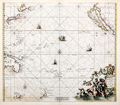 | Details | de Wit, Frederick | 1675 |
| Magnum Mare del Zur cum Insula California |
|
de Wit, Frederick |
|
| 1675 |
| LOC:0 |
| $3,100.00 | de-Wit--Frederick | Magnum-Mare-del-Zur-cum-Insula-California | This beautiful antique sea chart of the Pacific Ocean from 1675 is one of the earliest obtainable nautical charts of Oceana. The chart extends eastward from Japan, Korea and New Guinea to the newly explored west coast of North America with California shown as an island. The incomplete outline of landforms in Australasia reflect the limited exploration of that area.
<br></br>
This chart is the first and most desirable state, engraved by Frederick de Wit, with the imprint: "Gedruckt't Amsterdam by Frederick de Wit inde Calverstraet. " Published in de <b>Wit's Orbis Maritimus ofte Zee Atlas</b>, comprised of twenty-seven nautical charts of the world's oceans.
<br></br>
The concept that <b>Baja California was an island</b> rather than a peninsula dates back to the early 1500's. In 1701 Jesuit priest and cartographer Eusebio Francisco Kino published a map based on his explorations of the area showing Baja California to be a peninsula, but despite that work the question was not finally accepted by all cartographers until the mid-eighteenth century.
<br></br>
<b>Hollandia Nova</b>, or New Holland was the name given to the vast continent of Australia. On this early chart only the north coast of Australia and the Gulf of Carpentaria are depicted, with an incomplete outline of western New Guinea drawn above. Below, the outline of the southern half of Tasmania ( " Anthoni van Diemens Landt" ) and a portion of the east coast of New Zealand with the Cook Strait shown as a bay.
<br></br>
A very attractive decorative cartouche at bottom right features a portrait of Ferdinand Magellan gazing over a tableau of Poseidon and his consort Amphitrite riding a chariot through the sea while putti drape garland over the scene. Empty areas in the chart are filled with depictions of square-rigged warships under sail and firing cannon. Title is in Latin and Dutch. |
| 840 | 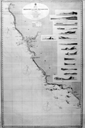 | Details | British Admiralty Hydrographical Office | 1868 |
| Antique Admiralty Nautical Chart of San Diego Bay to Cape Mendocino California |
|
British Admiralty Hydrographical Office |
|
| 1868 |
| LOC:63 |
| $3,000.00 | British-Admiralty-Hydrographical-Office | Antique-Admiralty-Nautical-Chart-of-San-Diego-Bay-to-Cape-Mendocino-California | Large antique British Admiralty sea chart of the California coast extending from Humboldt Bay and Cape Mendocino in the North, trending southeast past San Francisco Bay and Monterey Bay to San Diego, California. Lighthouses are picked out with red dots highlighted in yellow.
<br></br>
Contains fifteen coastal elevation views with some of the most stunning coastal scenery in the world including the Big Sur area. These carefully engraved coastal elevations include: Cape Mendocino, Point Arena, Pt. Reyes, Entrance to San Francisco Bay, Point Piedras, Point Ano Nuevo, South Farallon Lighthouse, Point Sur, Moro Rock, Point Arguilla, Pt. Conception, Point Loma, Catalina Harbor, and the Point of Boundary between the United States and Mexico.
<br></br>
First published by the Admiralty from London in April 1858 under the superintendence of Royal Navy Hydrographer Captain Washington. This edition of the scarce nautical chart was printed with corrections to July 1868.
<br></br>
Sold by J.D. Potter Agent for The Admiralty, 31 Poultry and 11 King Street Tower Hill. |
| 834 | 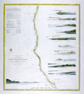 | Details | U.S. Coast and Geodetic Survey | 1869 |
| Western Coast of U.S. from San Francisco to Umpquah (Umpqua) River |
|
U.S. Coast and Geodetic Survey |
|
| 1869 |
| LOC:63 |
| $675.00 | U-S--Coast-and-Geodetic-Survey | Western-Coast-of-U-S--from-San-Francisco-to-Umpquah-(Umpqua)-River | Very attractive antique nautical chart of the <b>western coast of California</b> focused on the Pacific coastline between <b>San Francisco, California</b> and the Umpqua River, Oregon. This scarce, rolled, separately issued chart, corrected to 1869, was first published in 1854 by the U.S. Coast Survey. Noted habitations and geographical features include Empire City, Koos Bay, and Port Orford or Ewing Harbor, Oregon; Crescent City, Reddings Rock, Eureka, Mendocino City, Haven's Anchorage, Bodega Bay, Pt. Reyes, Alcatraz Island, Oakland, Alameda, Union City and San Francisco Bay, California. Numerous soundings, navigational hazards, and aids to navigation are identified.
<br></br>
This antique sea chart is enlivened with twelve attractive hand-colored <b>inset coastal elevation views</b> including: the Entrance to San Francisco Bay, Point Arena, Mendocino City Cove, Trinidad Head and City, Cape Mendocino, Red Bluff Entrance to Humboldt Bay, Point St. George, Mack's Arch and Reef, Rogues River, Cape Blanco, and Cape Gregory.
<br></br>
This is a scarce, separately issued, rolled nautical chart of the U.S. West Coast, not the more common folded version on thin paper that was issued with other charts in an annual report to Congress from the Coast Survey.
<br></br>
This chart was printed in 1869 from an electrotype-printed copy of the original hand-engraved copper plate. Electrotype printing is a process the U.S. Coast Survey adopted around 1850. As a soft medium, copper plates could only withstand print runs of perhaps 200 copies before the plates wore down. To enable larger print runs, a mold of the original plate was created in wax or another soft medium. Then, using an electro-chemical process ( electrotyping ), the mold was coated with a metal layer, typically copper. Printers were then able to produce output from the new electrotype copper copy, while preserving the original. Electrotype copy no. 6 by Mathiot. |
| 6693 |  | Details | U.S. Coast and Geodetic Survey | 1869 |
| Western Coast of U.S. San Francisco to Umpquah Umpqua River |
|
U.S. Coast and Geodetic Survey |
|
| 1869 |
| LOC:68 |
| $350.00 | U-S--Coast-and-Geodetic-Survey | Western-Coast-of-U-S--San-Francisco-to-Umpquah-Umpqua-River | This is an finely detailed antique coastal nautical chart of the <b>western coast of California</b>, which focuses on the Pacific coastline between <b>San Francisco, California</b> and the Umpqua River, Oregon. It is a scarce, rolled, separately issued chart, corrected to 1869, and was first published by the U.S. Coast Survey in 1854. Notable habitations and geographical features on the chart include Empire City, Koos Bay, and Port Orford or Ewing Harbor, Oregon, as well as Crescent City, Reddings Rock, Eureka, Mendocino City, Haven's Anchorage, Bodega Bay, Pt. Reyes, Alcatraz Island, Oakland, Alameda, Union City, and San Francisco Bay, California. The chart identifies numerous soundings, navigational hazards, and aids to navigation.
<br></br>
This antique sea chart features twelve detailed <b>inset coastal elevation views</b>, including the Entrance to San Francisco Bay, Point Arena, Mendocino City Cove, Trinidad Head and City, Cape Mendocino, Red Bluff Entrance to Humboldt Bay, Point St. George, Mack's Arch and Reef, Rogues River, Cape Blanco, Cape Gregory, and Point Reyes. It is a scarce, separately issued, rolled nautical chart of the U.S. West Coast, not the more common folded version on thin paper that was issued with other charts in an annual report to Congress from the Coast Survey.
<br></br>
The chart was printed in 1869 from an electrotype-printed copy of the original hand-engraved copper plate. The U.S. Coast Survey adopted electrotype printing around 1850 because copper plates, being a soft medium, could only withstand print runs of about 200 copies before the plates wore down. To allow for larger print runs, a mold of the original plate was created in wax or another soft medium. Then, using an electro-chemical process (electrotyping), the mold was coated with a metal layer, usually copper. Printers were then able to produce output from the new electrotype copper copy while preserving the original. Electrotype copy no. 6 was done by Mathiot. |
| 726 | 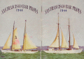 | Details | San Francisco Bar Pilots | 1944 |
| San Francisco Bar Pilots Tide Tables 1944 |
|
San Francisco Bar Pilots |
|
| 1944 |
| LOC:41 |
| $90.00 | San-Francisco-Bar-Pilots | San-Francisco-Bar-Pilots-Tide-Tables-1944 | Very cool pocket reference book issued by the San Francisco Bar Pilots in 1944, while the U.S.A. was still deeply involved in WWII. Card stock cover with photos of two of three pilot vessels working that port, both with sails: California #7, and the well-known schooner Gracie-S. #3. The Gracie-S was built by Union Iron Works of San Francisco and delivered to her original owners in December 1893 . She was 86 gross tons and 83 ft in length at the waterline, a rather large vessel for a pilot boat, but strong and comfortable with a total of twelve berths. This booklet shows she was still in service more than 50 years later. (Source: Pilots: Pilot Schooners of North America and Great Britain. Tom Cunliffe Ed. Wooden Boat publications. Brooklin, Maine. 2001. pp. 225-229.)
<br></br>
Contents include information on: sunrise and sunset times, pier locations in San Francisco, bridge heights, distances between ports, whistle calls and telephone numbers for harbor tug, tow boat, customs office, etc., names, addresses and home telephone numbers for all the bar pilots, tide tables, and a map at the center showing the channel back into San Pablo Bay and Suisun Bay.
<br></br>
The <a href="http://sfbarpilots.com/">San Francisco Bar Pilots web site</a> notes that the pilots of that organization have performed a demanding job guiding vessels in that challenging environment for more than 1.5 centuries:
<div class="indenttextblock">For more than 160 years, the San Francisco Bar Pilots have been guiding the world’s largest ships through some of North America’s most difficult waterways. Every day, the state-licensed Bar Pilots navigate commercial ships to and from the nine ports within San Francisco Bay and the Port of Monterey… With extreme care, the Bar Pilots deliver passengers, agricultural products, manufactured goods and hazardous materials throughout the Bay as far south as Redwood City, and as far inland as the Ports of Stockton and Sacramento.</div> |
| 721 |  | Details | La Perouse, Jean François Galaup | 1797 |
| Antique 1782 Plan of San Diego, California |
|
La Perouse, Jean François Galaup |
|
| 1797 |
| LOC:63 |
| $800.00 | La-Perouse--Jean-François-Galaup | Antique-1782-Plan-of-San-Diego--California | Two very attractive engraved antique nautical charts on one page of the harbors of <b>San Diego</b>, California (upper half) and San Blas, Mexico in Nayarit State. Locations around San Diego, California that are noted on the chart include: the Presidio de St. Diego, the 'faux port', Pointe des Morts, Rancherie de las Choyas, Pointe St. Augustin, Rancherie ou Village d'Indiens nomme de la Pointe, Pointe St. Joseph, Pointe St. Michel, Petite Port de St Jean, Pointe Guizarros, and Pointe de la Colline. Numerous soundings are included with descriptions of the composition of the sea floor on the approaches to and bottom of the San Diego Bay.
<br></br>
These two charts by Jean-Francois de la Perouse are based on surveys by Juan Pantoja, a captain of the Manila trade for Spain. Derived from Pantoja's manuscript, the charts were published posthumously in the "Atlas du Voyage de la Perouse 1785-1788". Plate 35.
<br></br>
San Blas was used by Spain's Navy as a naval base beginning in 1768 and it served for several decades as a base of operations for Spanish expeditions to the Pacific Northwest. For about twenty years in the late 18th century, San Blas was one of the busiest ports on the Pacific coast of the Americas, rivaling Acapulco. L. Aubert, scripsit.
<br></br>
As a French explorer and naval officer la Perouse (1741-1788?) was tasked by King Louis XVI of France with completing the Pacific exploration begun by British Captain James Cook. Aboard the ships Astrolabe and Boussole, la Perouse and his crew mapped the west coast of North America and Alaska in 1786 and visited Easter Island and the Sandwich Islands ( Hawaii ). After reaching Australia's Botany Bay in 1788 his ships were lost at sea while searching for the Solomon Islands. |
| 664 |  | Details | U.S. Coast and Geodetic Survey | 1853 |
| City of San Francisco, California |
|
U.S. Coast and Geodetic Survey |
|
| 1853 |
| LOC:63 |
| $1,400.00 | U-S--Coast-and-Geodetic-Survey | City-of-San-Francisco--California | Antique electrotype engraved plan of the booming town of San Francisco, California made in 1853 during the California gold rush. On a 25" x 33" sheet of heavy paper, never folded. Key named features include: Tonquin Shoal, Wreck of the Tonquin, Blossom Rock, Mission Rock, Point San Quentin, Mission de Dolores, Rincon Point, Mission Bay, Steamboat Point, Cunningham's Wharf, Law's Wharf, Broadway Wharf, Pacific Wharf, and Portsmouth Square.
<br></br>
The town is shown laid out into blocks with individual buildings. Numerous streets are identified including Market Street, Pine Street, Lombard Street and Broad Way. Includes numerous soundings and contour lines.
<br><br/>
This antique chart should not be confused with those similar copies that were issued with dozens of others as part of a Report to Congress, most on thin paper with folds that often show condition issues. This original mid 19th century survivor is a large, separately issued example on thick wove paper that has been stored either rolled of flat with no folds. Price 50 Cents. Verified I.I. Stevens . Outlines and Topography engraved by Max. F.O. Strobel; Lettering by E.F. Woodward. With the circular logo of the Coast Survey Depot. Number 627. |
| 607 |  | Details | U.S. Coast and Geodetic Survey | 1864 |
| Western Coast of U.S. from Umpqua River to the Boundary Uncolored |
|
U.S. Coast and Geodetic Survey |
|
| 1864 |
| LOC:63 |
| $475.00 | U-S--Coast-and-Geodetic-Survey | Western-Coast-of-U-S--from-Umpqua-River-to-the-Boundary-Uncolored | Rare, rolled, separately issued antique nautical chart ( 1864 ed. ) of the western coast of California focused on the Pacific coastline between the Umpquah River, Oregon north to the Canadian border. Noted with several habitations including Seattle, Astoria, and Olympia, Washington; Victoria, British Columbia; and Fort Langley. Many of the San Juan Islands are identified by name including Vancouver Island, San Juan, Lopez, Fidalgo, and <b> Guemes Island</b>.
<br></br>
This antique sea chart is enlivened with eight attractive engraved inset coastal profile views including: the Entrance to Columbia River / Cape Disappointment, Tatoosh Island, Flattery Rocks, Destruction Island, Tillamook Head, Cape Perpetua, and Cape Lookout.
<br></br>
The chart was first produced by the U.S. Coast Survey in 1855, a point in time when A.D. Bache was Superintendent.
<br></br>
This is a scarce, separately issued, rolled nautical chart of the area, not the more common folded version on thin paper that was issued with other charts in an annual report to Congress from the Coast Survey.
<br></br>
This chart was printed in 1864 from an electrotype copy of the original hand-engraved copper plate, a process the U.S. Coast Survey adopted around 1850. As a soft medium, copper plates could only withstand print runs of perhaps 200 copies before the plates wore down. To enable larger print runs, a mold of the original plate was created in wax or another soft medium. Then, using an electro-chemical process ( electrotyping ), the mold was coated with a metal layer, typically copper. Printers were then able to produce output from the new electrotype copper copy, while preserving the original. Electrotype copy no. 6, corrected to 1864." Scale 1 / 1,200,000. |
| 586 |  | Details | Belcher Abstract and Title Company | 1922 |
| Belcher's Pocket Map of Humboldt County, California |
|
Belcher Abstract and Title Company |
|
| 1922 |
| LOC:0 |
| $275.00 | Belcher-Abstract-and-Title-Company | Belcher-s-Pocket-Map-of-Humboldt-County--California | Compact folding topographic map of <strong>Humboldt County, California</strong> from 1922. Self-described as "The only accurate map of the County ever made". Contains a detailed record of drainage, railroads, settlements, roads, trails, section and township lines. Copyright 1922. (Note top of map image is in shadow.)
<br></br>
With an attached intact folding greenish-brown card-stock cover. Size when folded is approx. 4 1/2" W x 5 1/2" H. Price when sold $1.00. Compiled by the Belcher Abstract and Title Company of Eureka California. |
| 339 |  | Details | U.S. Geological Survey | 1892 |
| Entrance to San Francisco Bay |
|
U.S. Geological Survey |
|
| 1892 |
| LOC:3 |
| $140.00 | U-S--Geological-Survey | Entrance-to-San-Francisco-Bay | Small antique lithographed chart of the Entrance to San Francisco Bay. The chart, from the U.S. Geological Survey, is derived from a U.S. Coast Survey chart and overlaid with hachured topographic details. Lighthouses, soundings, life saving stations and navigational aids are shown. Water shown in blue. Some of the features include the Golden Gate (entrance to the bay), Ballenas Bay, Alcatraz Island, San Bruno, Point Lobos, and Pt. San Pedro. <BR> </BR>
Produced for the U.S. Geological Survey Thirteenth Annual Report. Produced by George S. Harris Lithographers, Philadelphia. Plate 45. |
| 30 |  | Details | Blondeau, Alexandre | 1820 |
| Carte de la partie de la Cote Nord-Ouest de L'Amerique |
|
Blondeau, Alexandre |
|
| 1820 |
| LOC:63 |
| $400.00 | Blondeau--Alexandre | Carte-de-la-partie-de-la-Cote-Nord-Ouest-de-L-Amerique | French copy of Vancouver's nautical chart of West North American coast from Alaska to Mexico. By Blondeau. Elsewhere attributed to Depot de la Marine but that is doubtful. Tracks of Vancouver's vessels, mountain ranges, missions, anchorages and a few soundings are clearly delineated.<BR> </BR>
Highly detailed (get a magnifier and enjoy) antique chart coverage extends down the coast from Kodiak Island, Alaska though Prince William sound, Port San Francisco and St. Diego California, into Mexico- Baie do Todos Santos, Baie de las Virgines, and ends near a marked anchorage near a mission 'St. Domingo'. California is described as "Nouvelle Albion".<BR> </BR> <BR> </BR>
Engraved and lettered by Blondeau: "Ecrit par M. Blondeau. Grave par Blondeau Rue et Porte St Jacques No 85." |