| | Thumbnail | | Creator | Date | Title / Author / Date / Location | Price | | | Description |
| 923 | 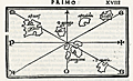 | Details | Bordone, Benedetto | 1534 |
| Very early map of Cadiz, Spain and the Azores, Portugal |
|
Bordone, Benedetto |
|
| 1534 |
| LOC:4 |
| $575.00 | Bordone--Benedetto | Very-early-map-of-Cadiz--Spain-and-the-Azores--Portugal | One of the earliest printed Azore Island maps (and another map of Cadiz, Spain) on a single sheet. Published from Venice in 1534 in the second edition of <b>Benedetto di Bordone's</b> nautical "Isolario", or Island Book.
<br></br>
The Isolario provided nautical-chart inspired maps of islands alongside information for travellers on their culture, myths, climate, and history.
<br></br>
A fine and original early nautical map of the <b>Azores islands</b>, in the Atlantic Ocean about 850 miles west of Portugal. Three islands on Bordonne's Azores map can be traced to their present-day equivalents: "S. Maria" (Santa Maria), "S. Georgio" (Sao Jorge), and "Samguimi" (Sao Miguel). Also shows the <b>mythical islands</b> of "Asmaida" and "Brasil" or Hy-Brazil as is is called in modern cartographic literature. Brasil island was long imagined to be located somewhere in the Atlantic Ocean to the west of Ireland. Brasil appears on several manuscript Portolani from the 14th and 15th century by Angelino Dulcert (1325), Andrea Bianco (1436) and others. Over almost 200 years several expeditions to find the Brasil were conducted by John Cabot, John Jay and others but as it was only an imaginary island the explorations failed.
<br></br>
Bordone's map of <b>Cadiz, Spain</b> (verso) is very interesting for its early place in the evolution of the cartography of that region. This map is almost cartoon-like in its simplicity. With the "Stretto de Gibilterra" defining the right limit of the map, and the "Regno de Castiglia" above, Cadiz is shown as a simple crescent shape slightly separated from the mainland. Towns that Bordone noted include "Gades" (Cadiz) , Turs, Tola, and S. Maria.
<br></br>
Bordone (1460-1531) was a Paduan cartographer, and an illustrator of manuscripts, best known for his 'Isolario' or book of islands. Bordone's work was only the second isolario ever printed, the first being that of Bartolommeo Dalli Sonneti published in 1485. Text in Italian. |
| 928 |  | Details | Bordone, Benedetto | 1534 |
| Early maps of Madeira and Ptolemaic Canary Islands |
|
Bordone, Benedetto |
|
| 1534 |
| LOC:7 |
| $950.00 | Bordone--Benedetto | Early-maps-of-Madeira-and-Ptolemaic-Canary-Islands | Two antique maps, one of Madeira, an island of Portugal in the Atlantic Ocean, and a curious map of the Atlantic islands on Africa's west coast based on the names and locations used by the Greeks and Romans. On the recto is the first printed map of the Portugese island of Madeira, by Benedetto Bordonne. Bordonne depicts the island as mountainous with numerous trees, and names four villages: "Camera de Lioni" (Câmara de Lobos); Fonzal" (Funchal); "Santa" (Sao Vincente); "Monerico" (Machico).
<br></br>
In his "Geography", Claudius Ptolemy, the Greco-Egyptian geographer lists a number of islands and their geographic coordinates. The verso contains one of the first printed maps showing the location of the Atlantic islands with Ptolemy's place names or that of the of the Roman geographer Pliny including: "Autolala" (Madeira), "Ninguaria" (Tenerife), "Canaria" (Gran Canaria), "Iunone" (Lanzarote or Fuerteventura), "Ombrio" (Ferro), and "Cisperia" (La Gomera). (Smith, William. <B>Dictionary of Greek and Roman Geography</b>. London. 1869. <a href="https://books.google.com/books?id=xgtAAQAAMAAJ&pg=PA906&lpg=PA906&dq=roman+names+for+canary+islands&source=bl&ots=2tZo3281lY&sig=rABlSnYBibeSpYSIR0SmvJp67Ms&hl=en&sa=X&ved=0CEMQ6AEwCDgKahUKEwjR28e1zerIAhXBJCYKHQ7VClc#v=onepage&q=906&f=false" target="_blank">Internet.)</a>
<br></br>
From the second Zoppino edition of Benedetto di Bordone's "<b>Isolario di Benedetto Bordone</b>" . This scarce antique map was published from Venice in 1534, just 42 years after Christopher Columbus first landed in the New World. The Isolario provided maps of islands alongside information for travellers on their culture, myths, climate, and history.
<br></br>
Bordone (1460-1531) was a Paduan cartographer, and an illustrator of manuscripts, best known for his 'Isolario' or book of islands. Bordone's work was only the second isolario ever printed, the first being that of Bartolommeo Dalli Sonneti published in 1485. |
| 929 |  | Details | Bordone, Benedetto | 1534 |
| Early map of Porto Santo Island in the Madeira archipelago |
|
Bordone, Benedetto |
|
| 1534 |
| LOC:7 |
| $350.00 | Bordone--Benedetto | Early-map-of-Porto-Santo-Island-in-the-Madeira-archipelago | Antique woodcut printed map of Porto Santo off the west coast of Africa in the Atlantic ocean. One of the earliest printed maps solely devoted to Porto Santo island, in the Portugese Madeira island group. By Benedetto Bordonne, who shows Porto Santo, Portugal in its geographical context with Madeira to the south and the west coast of Africa or "Getulia" to the east. Show several villages scattered around the island.
<br></br>
On a full sheet of Italian text. From the second Zoppino edition of Benedetto di Bordone's "<b>Isolario di Benedetto Bordone</b>" . This scarce antique map was published from Venice in 1534, just 42 years after Christopher Columbus first landed in the New World. The Isolario provided maps of islands alongside information for travellers on their culture, myths, climate, and history.
<br></br>
Bordone (1460-1531) was a Paduan cartographer, and an illustrator of manuscripts, best known for his 'Isolario' or book of islands. Bordone's work was only the second isolario ever printed, the first being that of Bartolommeo Dalli Sonneti published in 1485. |
| 987 | 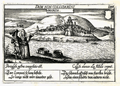 | Details | Meisner, Daniel | 1637 |
| Antique birds-eye view of Buarcos, Portugal |
|
Meisner, Daniel |
|
| 1637 |
| LOC:7 |
| $120.00 | Meisner--Daniel | Antique-birds-eye-view-of-Buarcos--Portugal | Small birds-eye view of Buarcos, Portugal by Daniel Meisner from 1637. Buarcos was a fishing village and is now a key beach resort, approximately 30 miles west of Coimbra, Portugal. From Meisner's famous emblematic atlas of the European (and a few foreign) cities. This view is a combination of two popular genres - the Emblem Book and the Book of Town Plans, e.g. the Civitates of Braun and Hogenberg.
<br></br>
Here Meisner's Latin and German verses echo the motto "Dum Non Collidamini" (So long as they don't collide) describing the usefulness of earthenware jars but the peril of breaking if they are banged together, thus the imagery of the two jars floating downstream. The metaphor is extended to interpersonal relations for the man and the woman seek to avoid "collisions" as well. |
| 1102 | 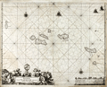 | Details | Loots, Johannes | 1700 |
| Pascaerte vande Vlaemsche Eylanden |
|
Loots, Johannes |
|
| 1700 |
| LOC:9 |
| $2,500.00 | Loots--Johannes | Pascaerte-vande-Vlaemsche-Eylanden | Singular rare nautical chart of the Azores Islands (Vlaemsche = Flemish) by Dutch cartographer Johannes Loots, ca 1700. Pascaerte vande Vlaemsche Eylanden is not recorded in Koeman's Atlantes Neerlandici. <B>No record of another copy of this chart is found online or in cartograhic reference sources.</b> Charts by Johannes Loots are very scarce; only eight charts by Loots are recorded in the Antique Map Price Record covering 210,000 map and chart sales in the last 35 years.
<br></br>
Scrollwork title cartouche with putto and horses led by robed young men and topped with an armillary sphere on a pedestal.
<br></br>
The topography of the Azores islands closely resembles that on an an earlier chart with the same title produced by Arnold Colom but differences in the rhumb lines, cartouches, lattitude marks, compass roses and decorations strongly suggest that this chart was printed from a new plate engraved for Loots.
<br></br>
From Koeman's biography of Johanne's Loots (1665[6] - 1726) we know Loots was born in Amsterdam and is not as is sometimes believed one of the two sons of Anthonie (Theunisz) Jacobsz who named themselves Lootsman to confuse cartographic researchers in future centuries. Loots served an apprenticeship under Hendrick Doncker as a maker of mathematical and nautical instruments including cross-staffs. Loots was accepted into the Guild of Booksellers in 1693 and settled into a shop in the Nieuebrugsteeg 'In de Jong Lootsman'. Two well-known competing catographers lived on the same street- Johannes van Keulen and Hendrick Doncker. |
| 785 | 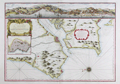 | Details | Bellin, Jacques Nicolas | 1756 |
| Antique chart of Lisbon and Setubal, Portugal with the Tagus River |
|
Bellin, Jacques Nicolas |
|
| 1756 |
| LOC:57 |
| $1,600.00 | Bellin--Jacques-Nicolas | Antique-chart-of-Lisbon-and-Setubal--Portugal-with-the-Tagus-River | Beautiful, antique plan and chart of the Tagus River, Lisbon, Portugal and surrounding area. At the top the entire width of this scarce nautical chart contains a detailed panoramic profile view of Lisbon ( Lisbonne ) westward past Belem as it existed in the mid-eighteenth century with the core city surrounded by walls. Would make a fine gift for anyone with an interest in boating or other maritime activities in the area of Lisbon, Portugal.
<br></br>
At that time the size of the city was much smaller than today- Belem ( Bourg de Belem ) and the Tower of Belém ( Tour de Belem ) are far outside the city walls. An inset plan below the decorative title cartouche shows detailed information about Lisbon and an explanatory legend. These important feature include : le Chateau; la Palais du Roy; the customs house- la Douane; and a major shipyard - Chantier pour la construction des Vaisseaux. Coverage includes several areas that are popular today with tourists including Sintra ( Cintra ), and Cascais, on the Atlantic coast near Cabo de la Roca.
<br></br>
Numerous geographical and topographical features including: Setubal, Colares, Fort St. Antoine, Fort de St. Julien, Village de Passe d'Arc', the convent of Notre Dame de Bon Voyages, Sacaven, Port Brandan, Fort de Bougie, Romeira, Cap Spichel, Sezimbre, and Fort St. Philippe.
<br></br>
With rhumb lines and an attractive compass rose with an adjustment for magnetic variation. As expected on a sea chart there are numerous soundings, anchorages, and hazards including several long reefs off the mouth of the Tagus River. Published by J.N. Bellin for France's Depot de La Marine. |
| 1011 |  | Details | Depot de la Marine | 1791 |
| French Chart of the Azores Island, Portugal |
|
Depot de la Marine |
|
| 1791 |
| LOC:54 |
| $750.00 | Depot-de-la-Marine | French-Chart-of-the-Azores-Island--Portugal | Antique chart from 1791 of the Azores Islands, off the coast of Portugal. This chart "Carte réduite des Isles Açores" is a 1791 French sea chart based on the earlier observations of Tofino de San Miguel, of the Spanish Admiralty. Contains numerous elevation profile views of the Azores coastline as seen from sea. Coverage inccludes the islands of Corvo, Flores, Graciosa ("Gracieuse"), Terceira, São Jorge, Pico, Faial, São Miguel, and Santa Maria. |
| 510 |  | Details | Malham, John | 1797 |
| A Correct Chart of the Coast of Portugal engraved for Malham's Naval Gazetteer |
|
Malham, John |
|
| 1797 |
| LOC:7 |
| $185.00 | Malham--John | A-Correct-Chart-of-the-Coast-of-Portugal-engraved-for-Malham-s-Naval-Gazetteer | Early U.S. printed sea chart of Portugal's Atlantic coast from 37 to 42 degrees North Latitude. From the rare first American edition of Malham's Naval Gazetteer, published by Spotswood and Nancrede in Boston. Vol 2.<BR> </BR>
This chart comes from an early nautical gazetteer produced first in England and after 1796 in Boston, Massachusetts. Coverage includes Seville, Cape St. Vincent, Sagres, Setuval, Lisbon, Coimbra, and Oporto. Just below the fleur-de-lis pointing North is a notation: "About this spot is supposed to exist a submarine volcano that occasioned the earthquake Nov 1, 1755." This earthquake, referred to as the "Great Lisbon Earthquake", killed over 10,000 people in Lisbon alone.
Rev. John Malham was a prolific Yorkshire-born author. Malham died near London in 1807. (Gentleman's Magazine, Vol 102, 1807, p. 568).<BR> </BR> |
| 258 | 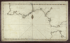 | Details | Randle, Charles | 1813 |
| Sold- Manuscript Chart - Portugal, Spain, Strait of Gibraltar |
|
Randle, Charles |
|
| 1813 |
| LOC:0 |
| $0.00 | Randle--Charles | Sold----Manuscript-Chart---Portugal--Spain--Strait-of-Gibraltar | This manuscript chart is sold.<br></br>
Small manuscript sea chart of Spain, Portugal and the Strait of Gibraltar. Signed and dated "C. Randle May 18, 1813". Despite the relatively small size of this manuscript chart, the author spent considerable time drawing fine detail of navigational hazards and features. The Guadalquivir River is shown past the bridge in Seville and the Guardiana River is shown to Alcoutin with some details that suggest the author was very familiar with its navigation. <br></br>
Charles Randle (fl. 1775 - 1813) served as an officer in the British Royal Navy during both the battle for American independence from Great Britain and
the war of 1812. Records show Randle held the rank of Lieutenant in 1783 and retired in 1820 with the rank of commander. <br></br>
Randle is best known for several watercolor drawings he produced during the time of the American Revolution. These include several drawings of the
battle of Valcour Island that show the British and American lines of battle . These and other drawings he made from that period are presumably based on his first-hand knowledge as a participant at those events. All are signed as C. Randle and are dated between 1775 and 1778.<br></br>
The Library of Congress records holding of 37 manuscript maps and 46 watercolor views signed C. Randle and dated to 1810 .<br></br> |
| 836 | 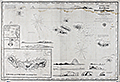 | Details | Purdy, Isaac | 1861 |
| Blueback sea chart of the Azores |
|
Purdy, Isaac |
|
| 1861 |
| LOC:0 |
| $2,700.00 | Purdy--Isaac | Blueback-sea-chart-of-the-Azores | Blueback sea chart by Isaac Purdy of the Azores Islands off the West coast of Portugal. 10 coastal elevation views include: Terceira and the Peak of Pico; Corvo and Flores. Inset port plans include: Channel between Fayal and Pico; the Road of Angra; and S. Miguel or St. Michael.
<br></br>
Published by R.H. Laurie. 53 Fleet Street, London in January 1861.
<br></br>
During the 1800's there was a trend toward publication of very large small-scale charts with large-scale insets of key passages and harbors. This made it possible for mariners to replace perhaps a half-dozen or more charts with just one. The practice was adopted as much for economics as any other reasoner. Laurie was one of a handful of British publishers who specialized in these charts which were often backed with canvas or linen cloth or heavy blue paper in order to help them withstand the frequent use and abuse aboard ship, hence the term "blueback chart". |
| 596 | 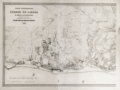 | Details | Direccao Geral dos Trabalhos Geodesicos | 1884 |
| Carta Topographica da Cidade de Lisboa |
|
Direccao Geral dos Trabalhos Geodesicos |
|
| 1884 |
| LOC:0 |
| $900.00 | Direccao-Geral-dos-Trabalhos-Geodesicos | Carta-Topographica-da-Cidade-de-Lisboa | Scarce extra-large (42" wide) antique, rolled map of Lisbon (Lisboa), Portugal. Lithograph. This large sheet is the left half of a two sheet map of Lisbon published in 1884. Finely engraved with minute topographical details visible.
<br></br>
Produced by Portugal's Direccao Geral dos Trabalhos Geodesicos. One vertical fold as issued. |
| 1129 | 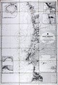 | Details | British Admiralty Hydrographical Office | 1924 |
| West Coast of Spain and Portugal |
|
British Admiralty Hydrographical Office |
|
| 1924 |
| LOC:0 |
| $0.00 | British-Admiralty-Hydrographical-Office | West-Coast-of-Spain-and-Portugal | <br></br>
SOLD
<br></br>
<br></br>
A fine folding British sea chart of the Atlantic coastline of Spain and Portugal from a chart originally published at the Admiralty in 1873, but this a later edition corrected to 1924.
<br></br>
This handsome chart provides numerous depth soundings, lighthouse locations, coastal details, and other hydrographic information from the Algarve coastline near Lagos, Portugal working northward past Lisbon and Oporto and ending near Cape Finisterre in Spain.
Six inset port plans including:
<div class="indenttextblock">
<ul style="list-style-type: circle;">
<li>Port Leixoes</li>
<li>Sines Bay</li>
<li>Cezimbra Bay</li>
<li>Peninsula of Peniche</li>
<li>Port Figueria</li>
<li>River Douro</li>
</ul>
</div>
Dissected and laid to fine linen. Early 20th century edition with last correction in 1924. Sellers label on the verso for Sifton, Praed, & Co. Ltd. The Map House. 67 St. James Street, London S.W. Owners ink stamp on cover "H.F. Cronin." Marbled board covers. |
| 4767 | 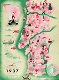 | Details | Botelho, Carlos | 1937 |
| Portugal 1937 Exposition Internationale de Paris |
|
Botelho, Carlos |
|
| 1937 |
| LOC:88 |
| $400.00 | Botelho--Carlos | Portugal-1937-Exposition-Internationale-de-Paris | Very fine map of Portugal in a simple, folksy, pictorial style. For a brochure "Portugal Gastronomique" to support the Portuguese exhibit at the 1937 International Exhibition of Arts and Techniques in Paris, France May 4 to November 27, 1937. There, pavilions of the participating countries were built along the Seine. These structures were projects by the outstanding architects of the time.
<br></br>
On the recto French text written by Albino Forjaz Sampaio and simple images related to traditional Portuguese food.
(Source: http://garfadasonline.blogspot.com/2013/04/portugal-gastronomico-na-exposicao-de.html
<br></br>
Signed within as "Botelho 37". Carlos Botelho (1899-1982) was a multi-faceted artist, illustrator, and caricaturist. Lito National - Porto. |