| | Thumbnail | | Creator | Date | Title / Author / Date / Location | Price | | | Description |
| 8034 |  | Details | Mayson, Thomas | 1875 |
| Victorian exhibition advertisement for Mayson’s Relief Ordnance Model |
|
Mayson, Thomas |
|
| 1875 |
| LOC:89 |
| $200.00 | Mayson--Thomas | Victorian-exhibition-advertisement-for-Mayson’s-Relief-Ordnance-Model | Original Victorian exhibition advertisement for Mayson’s 3D Ordnance relief model of the Lake District, Cumbria, North West England, created in 1875 as a major visitor attraction in Keswick. The broadside announces the enormous 210 square foot model exhibited daily at the Lake District Repository on Lake Road, a sculpted landscape built to a scale of six inches to the mile and rendered with exactness from Ordnance Survey data. Bold Victorian lettering, fern motifs, and a vignette of the Repository building frame the promotional text, which highlights mountains, lakes, rivers, waterfalls, villages, and roads shown in full relief and hand colored to nature.
<br><br>
The model was commissioned by Keswick photographer Henry Mayson and his brother Thomas and built by the Italian sculptor Raffaelle Monti and his team using Ordnance Survey sheets as the mathematical basis for every contour. The advertisement stresses its practical value for travelers, noting that the model was an essential tool for planning excursions and understanding the correct topography of the Lake District at a time when tourism was rapidly increasing. Daily opening hours, illumination during summer months, and a one shilling admission charge appear prominently in the lower text block.
<br><br>
As an example of nineteenth century exhibition ephemera, this poster documents one of the most ambitious public relief models ever constructed in Britain and preserves the original marketing for a landmark Lake District attraction. Surviving advertisements for Mayson’s Ordnance Model are scarce, and this sheet stands as a desirable item for collectors of British posters, Lake District history, and early Ordnance Survey derived cartography. |
| 7984 | 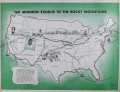 | Details | Howells, Rulon S. | 1961 |
| Map of The Mormon Exodus to the Rocky Mountains |
|
Howells, Rulon S. |
|
| 1961 |
| LOC: |
| $300.00 | Howells--Rulon-S- | Map-of-The-Mormon-Exodus-to-the-Rocky-Mountains | Scarce mid-20th-century educational wall poster depicts the westward migration of the Mormon pioneers from the eastern United States to the Great Salt Lake Valley. The map traces multiple overland and sea routes—from early settlements in New York, Ohio, and Illinois across Iowa, Nebraska, and Wyoming to Utah—with fine line work and green-toned shading that visually emphasizes the journey’s progression.
<br><br>
Illustrations along the route show covered wagons, handcarts, and pioneer figures, while smaller vignettes depict scenes such as the Mormon Battalion’s march and seaborne emigrant routes from Europe. At lower left, a narrative block summarizes the migration’s history, noting Brigham Young’s leadership and the founding of the Great Salt Lake settlement in 1847.
<br><br>
Printed in green and black on white stock, the map carries the imprint: “A Teaching Aid – The Mormon Story – Teaching Aids, Inc., Highland Park, Illinois.” This poster was likely used in classrooms and religious education settings during the 1960s, part of a broader trend toward illustrated historical maps as visual teaching tools. An attractive and informative example of mid-century American educational cartography.
<br><br>
Published by Bookcraft, Inc, 1961. |
| 6738 |  | Details | Soule, George | 1859 |
| Very Rare Antebellum New Orleans advertisement Soule Commercial College |
|
Soule, George |
|
| 1859 |
| LOC:150 |
| $6,500.00 | Soule--George | Very-Rare-Antebellum-New-Orleans-advertisement-Soule-Commercial-College | Very rare New Orleans imprint antebellum broadsheet advertisement or "Balance Sheet Circular" produced by George Soule to advertise Soule's Commercial College, established 1856 at the corner of Camp Street and Common Street, in New Orleans, Louisiana. A finely detailed lithograph featuring exquisite calligraphy, numerous inset views of commercial activities, and four example financial statements, including at bottom right, "Statement of Steamer Eclipse Trip No. 8 T.R. Winn Master."
<br><br>
An online search found only one copy of Soule's "Balance Sheet Circular", at the Historic New Orleans Collection.
<br><br>
<div id="6738" align="center">
<a title=""></a>
<img id="6738" src="/ZoomifyImages/SC_6738/SC_6738_400x300.jpg" alt=" Antebellum advertisement for Soule's Commercial College, established 1856 in New Orleans, LA." width="340"/> <br><br> <font size="-2">Soule's Commercial College Balance Sheet Circular</font>
</div><br>
Lithographed by J. Manouvrier. (2) This fine lithograph with beautiful calligraphy was printed in New Orleans in 1859, just after Soule opened the College at Camp and Common Streets. Between 1856 and 1860 Soule's Commercial College graduated a total of more than 275 students. By 1905 the school could boast 1000 students enrolled, 20 teachers, and over 19,000 former students. The school operated in New Orleans continuously, except for a few years during the Civil War, until 1983 when it finally closed.
<br><br>
<div id="6738_2" align="center">
<a title=""></a>
<img id="6738_2" src="/ZoomifyImages/SC_6738/SC_6738_Detail_2.jpg" alt=" Antebellum advertisement for Soule's Commercial College, a view of Jackson Square." width="340"/> <br><br> <font size="-2">Early View of Jackson Square, New Orleans</font>
</div> |
| 6696 | 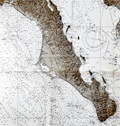 | Details | U. S. Navy Oceanographic Office | 1964 |
| United States Navy Chart of Baja California. |
|
U. S. Navy Oceanographic Office |
|
| 1964 |
| LOC:68 |
| $225.00 | U--S--Navy-Oceanographic-Office | United-States-Navy-Chart-of-Baja-California- | Very large original U. S. Navy chart of the Baja Peninsula and the Gulf of California. U.S. and British Admiralty charts of Baja California are among the most requested items on RareCharts.
<br><br>
Dark shading on land areas enhances the contrast between land and sea. Manuscript traces of faded writing.
<br><br>
<div id="0" align="center">
<a title=""></a>
<img id="6648" src="/ZoomifyImages/SC_6696/SC_6696_detail.jpg" alt="Very large original U. S. Navy chart of the Baja Peninsula and the Gulf of California, 1964" width="340"/> <br><br> <font size="-2">Baja- La Paz Bay and Isla Espiritu Santo</font>
</div><br>
"Mexico - West Coast Cabo San Lazaro to Cabo San Lucas and Southern Part of Golfo de California. From U. S. Navy Surveys between 1873 and 1901 with additions in 1962". 1st edition was in 1876 but this 68th edition last revised in June, 1964. Mercator projection. Catalog region 2. Chart # 621. |
| 6544 |  | Details | Thrall, Willis | 1831 |
| Map of the United States Compiled from the Most Authentic Sources |
|
Thrall, Willis |
|
| 1831 |
| LOC:1405 |
| $1,900.00 | Thrall--Willis | Map-of-the-United-States-Compiled-from-the-Most-Authentic-Sources | This scarce "Map of the United States Compiled from the Most Authentic Sources" is a historical map of the United States published in 1831 by Willis Thrall, a cartographer and publisher based in Hartford, Connecticut. Thrall's map includes detailed information about state and territorial boundaries at that time, major cities and towns, rivers, mountains, and other geographical features. The area now containing Texas, Arizona, New Mexico and California is labeled "Internal Provinces of Mexico."
<br><br>
One notable feature of the map is the inclusion of a combined distance table between major cities with population statistics for each in 1820 and 1830. Thrall's map of The United States contains inset maps for: <div class="indenttextblocksingle">
<ul style="list-style-type: circle;"></li>
<li>North America</li>
<li>City of New York and Vicinity</li>
<li>District of Columbia</li>
<li>Boston and its' Vicinity</li>
</ul>
</div>
Bottom of the map contains the statement "Copyright Secured." The United States passed its first copyright law on May 31, 1790, under the Copyright Act of 1790. This law established the legal framework in the United States for protecting the original works of authors, including books, maps, and charts, by granting them exclusive rights to their work for a period of 14 years.
<br><br>
As a native New Orleanian I found it interesting that the map locates a small town north of New Orleans- Madisonville, La. (today pop. < 900). I was unaware that in the 1830s, the area around Madisonville became a very important center for the timber industry. Large sawmills were built along the Tchefuncte River to take advantage of the abundant timber resources in the area, and the town became a hub for shipping timber and other goods to New Orleans. |
| 6492 | 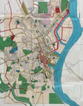 | Details | Dubuque City Planning Commision | 1951 |
| Master Plan for the City of Dubuque Iowa |
|
Dubuque City Planning Commision |
|
| 1951 |
| LOC:400 |
| $400.00 | Dubuque-City-Planning-Commision | Master-Plan-for-the-City-of-Dubuque-Iowa | Very large, scarce 1951 master plan map of the City of Dubuque, Iowa by the Dubuque City Planning and Zoning Commission, J.M. Wolfe, Chairman. Justin R. Hartzog, City Planner. A fine record of the city and its ambitions in the mid 20th-century.
<br><br>
Two matching legends at bottom right and left show symbols and coloration used for mapped features under existing conditions and for the Commission's planning proposals respectively. These details include streets, railroads, intersections, city boundaries, parks, playgrounds, schools and other land uses. North oriented to top. |
| 6493 |  | Details | Ohio Department of Highways | 1966 |
| Large pictorial map of the State of Ohio |
|
Ohio Department of Highways |
|
| 1966 |
| LOC:400 |
| $185.00 | Ohio-Department-of-Highways | Large-pictorial-map-of-the-State-of-Ohio | Large pictorial map of the State of Ohio. Copyrighted and published in 1966 by the Ohio Department of Highways.
<br><br>
<div id="3" align="center">
<a title="Detail from See the Wonderful World of Ohio map."></a>
<img id="3" src="/ZoomifyImages/SC_6493/SC_6493_Detail.jpg" alt="The Ohio River, 455 miles of water wonderland." width="360"/> <br><small>The Ohio River, 455 miles of water wonderland.</small>
</div><br>
Verso with additional road map, text, and photographs. |
| 6470 | 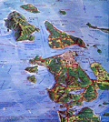 | Details | Pargeter, Richard Arnold | 1980 |
| Pictorial oblique topographic birds-eye view of the San Juan Islands |
|
Pargeter, Richard Arnold |
|
| 1980 |
| LOC:150 |
| $450.00 | Pargeter--Richard-Arnold | Pictorial-oblique-topographic-birds-eye-view-of-the-San-Juan-Islands | An original fine panoramic relief map of the San Juan Islands in Washington State on an oblique perspective. Copyright 1980 by Richard Pargeter. Printed by University Printing Company, Seattle. Pencil stock number in bottom right margin.
<br><br>
A self-taught cartographic illustrator, Pargeter's output includes similar panoramic relief maps of The Olympic Peaks, the Puget Sound Country, and Washington's Northwest Passages. In 1980, when this map was copyrighted, copies were available by mail-order from the Pargeter Company in Kent, Washington. Pargeter's maps were once available online but all available copies are reported as sold-out.
<br><br>
<div class="indenttextblocksingle">
"Tens of thousands of these maps have been sold over the years. All Pargeter's maps are true oblique projections. No planimetrics. All, but the pre-color-separated Olympic map have been full-color halftone shaded relief illustrations rendered in acrylics and a very fine brush, The renderings are based on U.S.G.S. topo quads with mountain "facial features" derived from aerial oblique angle photos taken by Pargeter". [1]
</div><br>
Source
<br><br>
[1] Online: Panorama maps. Pargeter. Online: http://www.panorama-map.com/pargeter/pargeter.html |
| 6451 | 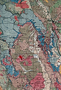 | Details | U.S. Geological Survey | 1935 |
| Fine large Geologic Map of Colorado |
|
U.S. Geological Survey |
|
| 1935 |
| LOC: |
| $500.00 | U-S--Geological-Survey | Fine-large-Geologic-Map-of-Colorado | Original large folding Geologic Survey Map of Colorado [1] from 1935, dissected and laid to linen. With an inset index map of Colorado. Includes an impressive table of the principal sources of geologic data that were used to compile the map of Colorado, USA. Published by the Department of the Interior, U.S. Geological Survey.
<br><br>
Scarce in this format. Type of rock (igneous, metamorphic, sedimentary) is indicated by color keyed to an extensive index scattered across the right side of the map.<br><br>
[1] Geologic Map of Colorado by the United States Geological Survey W. C. Mendenhall Director in cooperation with the Colorado State Geological Survey Board and Colorado Metal Mining Fund 1935. |
| 4862 | 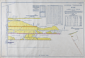 | Details | Foreman, D. H. | 1916 |
| Antique Plans Hidden Treasure Mine Lake City, Colorado |
|
Foreman, D. H. |
|
| 1916 |
| LOC:0 |
| $3,250.00 | Foreman--D--H- | Antique-Plans-Hidden-Treasure-Mine-Lake-City--Colorado | The most interesting set of gold mining plans I have seen!
<br><br>
A very absorbing pair of fine antique presentation plans for the Hidden Treasure Mine at Lake City, in Hinsdale County, Colorado between Crystal Creek and Ute Creek. The Hidden Treasure Mine (1897-1922) was a gold, silver, lead, and copper mine located at an elevation of 10,200 feet.
<br><br>
Both plans are hand-colored blue-line artifacts on architectural vellum.
<b>Plan 1 includes:</b>
<div class="indenttextblocksingle">
<ul style="list-style-type: circle;">
<li>Fig 1. Plan Map of the Hidden Treasure Property</li>
<li>Fig 2. Longitudinal Section of Slope of Vein Looking West.</li>
<li>Fig 3. Plan of Underground Workings.</li>
</ul>
</div>
<b>Plan 2 includes:</b>
<div class="indenttextblocksingle">
<ul style="list-style-type: circle;">
<li>Fig 4. Longitudinal Section Underground Workings. Looking West.</li>
<li>Fig 5. Cross-section Through "X-Y" (Plate 1) Looking S.W.</li>
<li>Sampling data and ore valuation table.</li>
</ul>
</div>
Dated within to 12/20/16. Drawn by D.H. Foreman, Denver, Colorado.
<br></br>
The old Hidden Treasure Dam on Henson Creek, built in the 1890's, made the news in late May, 2019. It was announced that the dam was to be demolished because of the concern for flash floods associated with the potential for sudden heavy snowmelt. (Source: https://www.cpr.org/news/story/historic-hidden-treasure-dam-is-coming-down-to-ease-the-flood-threat-to-lake-city)
<br></br>
On Fig 1. Plan Map of the Hidden Treasure Property two tunnels are shown leading to the Lower Terminal Mill. More than 100 years old, the Hard Tack Mine tunnel was built as an underground transport tunnel for the Hidden Treasure Mining Company's ore production one quarter mile up the mountain (shown here as "proposed"). The Hardtack Mine now (2024) houses a museum designed to preserve area mining history and offers tours June to September. |
| 3624 | 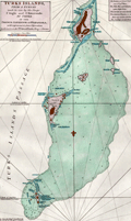 | Details | Jefferys, Thomas | 1775 |
| Antique Chart of the Turks Islands and Turks Islands Passage |
|
Jefferys, Thomas |
|
| 1775 |
| LOC:51 |
| $900.00 | Jefferys--Thomas | Antique-Chart-of-the-Turks-Islands-and-Turks-Islands-Passage | A fine original antique British chart of the <b>Turks Islands</b> in the Caribbean Sea engraved by Thomas Jefferys. Covers Grand Turk Island, Salt Key, Sand Key, Cotton Island, Pelicans Island, and others in the vicinity. A foundational map for collectors, it is the earliest obtainable sea chart to focus solely on the Turks Islands, today a British Overseas Territory. (Note: The Caicos Islands are not included on this chart.)
<br></br>
Shows rocks, banks, reefs, shoals, anchorages, "Salt Rakers Huts" on the 2 main islands, rhumb lines. Printing done from a hand-engraved copper plate by Jefferys.
<br></br>
At Sand Key at point "A", on the Southern Bluff, a note reveals <div class="indenttextblock"> " Upon this bluff (Sand Key) the French, after the late Peace, erected a Sea Mark which they were soon obliged to demolish."</div>
<BR/>
The chart is from the scarce <b>first edition of the West India Atlas" 1775 by Sayer</b>, the other issues being 1781, 1787, 1794, 1796, 1807, and 1818 published by Sayer and then Laurie and Whittle. <a href="https://www.davidrumsey.com/home" target="_blank">(Online).</a>
<br></br>
From: "The West-India Atlas: or, A Compendious Description of the West-Indies: illustrated with Forty Correct Charts and Maps, taken from Actual Surveys. Together with An Historical Account of the Several Countries and Islands which compose that part of the world. Their Discovery, Situation, Extent, Boundaries, Product, Trade, Inhabitants, Strength, Government, Religion, &c."
Author: Thomas Jefferys.
Publishers: Robert Sayer.
Jefferys died in 1771; Sayer acquired Jefferys' materials in preparation for this atlas, and published the atlas posthumously under his name. |
| 1397 | 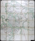 | Details | Norfolk City Planning Commission | 1924 |
| Large 1921 Planning Commission Map of Norfolk, Virginia and Vicinity |
|
Norfolk City Planning Commission |
|
| 1924 |
| LOC:2001 |
| $1,000.00 | Norfolk-City-Planning-Commission | Large-1921-Planning-Commission-Map-of-Norfolk--Virginia-and-Vicinity | Impressive huge lithographed folding map of Norfolk in the Commonwealth of Virginia. Boundary lines mark the city's boundary with Norfolk County and to its east Norfolk County's boundary with Princess Anne County. This 1924 edition is the first revision of the original 1921 Norfolk City Planning Commission map (other revisions were in 1928 and 1939). Compiled by Paul F. Mueller C.E., who worked for Sanborn Map Co. until 1906. (Norfolk Virginia: Evolution of a City in Maps. Berent, Irwin M. Norfolk History Publihers. 2013. pp. 23-25. <a href="https://books.google.com/books?id=sQsvAQAAQBAJ&pg=PA25&lpg=PA25&dq=Norfolk+and+Vicinity,+City+Planning+Commission+map+1921&source=bl&ots=BHr35I7PFg&sig=qOBa1pA-rTOpTKgYZ26zxMS-_3w&hl=en&sa=X&ved=0ahUKEwjE_L-p5oTYAhVR1IMKHSIWCXEQ6AEIRzAJ#v=onepage&q=Norfolk%20and%20Vicinity%2C%20City%20Planning%20Commission%20map%201921&f=false" target="_blank">Online.</a>)
<br></br>
Numerous printed notes of historical interest, for example: "Near this spot was the "Mother Church" of Elizabeth River Parish. See Book 4, Page 175, 3 January 1684." Key features on this map include Willoughby Bay, Boush Creek, Mason Creek, Little Creek, Elizabeth River, Lafayette River, Craney Island, and Port Norfolk.
<br></br>
Pencil annotation for Ward's Corner.
<br></br>
Norfolk is located at the heart of the Hampton Roads metro area. Named for the large natural harbor of the same name located at the mouth of Chesapeake Bay, Norfolk It is one of nine cities and seven counties that constitute the Hampton Roads metro area. The city has a long history as a military and transportation hub. The largest Navy base in the world, Naval Station Norfolk, is located in Norfolk, Va.
<br></br>
With label for C.S. Wertsner & Sons, Maps and Mounting, 50 North 13th Street, Philadelphia, Pa. Lithographed by A. Hoen and Co., Baltimore. |
| 1333 |  | Details | U.S. War Department | 1934 |
| Old War Department Map of New Orleans Area 1934 |
|
U.S. War Department |
|
| 1934 |
| LOC:1401 |
| $450.00 | U-S--War-Department | Old-War-Department-Map-of-New-Orleans-Area-1934 | Large, original War Department / U.S. Corps of Engineers blueprint index map from 1934 for south-eastern Louisiana including New Orleans, Donaldsonville, Baton Rouge, Mandeville, Slidell and Bay St. Louis. Names railways, numerous waterways and bodies of water, but does not show roads or highways. Includes the Bonnet Carre Floodway (completed 1931), the Harvey Locks, portions of the Intracoastal Canal (later called the Gulf Intracoastal Waterway or ICWW), Lake Borgne, Lake Ponchartrain, Barataria Bay, Atchafalaya Bay, and the Mississippi River as far south as Venice, Louisiana. Perfect for the man cave.
<br></br>
On this map the route shown for the Intracoastal Canal passes through Lockport, Louisiana and Bayou Terrebonne. The segment of the canal from Larose to Bourg, Louisiana to was not completed until 1949.
<br></br>
Dated within at bottom right to 1934. Drawn by L. Lecaze. |
| 1198 | 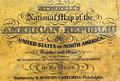 | Details | Mitchell, Samuel Augustus | 1843 |
| Mitchell's National Map of the American Republic first ed. |
|
Mitchell, Samuel Augustus |
|
| 1843 |
| LOC:0 |
| $1,400.00 | Mitchell--Samuel-Augustus | Mitchell-s-National-Map-of-the-American-Republic-first-ed- | Large 1st edition linen-backed hanging map of the eastern United States surrounded with insets of the vicinity of major towns, ports, and harbors. This scarce map features 32 colored insets of United States cites including New Orleans, St. Louis, Nashville, Natchez, Mobile, Savannah, Charleston, Raleigh and many more. Population tables for each county in the different states and territories in 1840. Eastern Kansas and Oklahoma are shown combined and is labeled "Indian Territory" with tribes identified including Omaha's, Kickapoos, Cherokee, and Shawnee. Large Iowa Territory. Minnesota is not yet named foreshadowing the Westward population expansion to follow in later decades.
<br></br>
With an inset map of the Treaty of 1842, also called Webster-Ashburton Treaty settling a border dispute between Maine and New Brunswick.
<br></br>
Samuel Augustus Mitchell Sr. (1792-1868) is one of the pioneers in American cartography of the 19th century and led the conversion of engraved map plates to more affordable lithographic plates. Drawn by James Henry Young (1817-1866) and engraved by J.H. Brightly, both collaborated with Mitchell on this series of maps. Published from 8 1/2 South Seventh Street, Philadelphia. Wall map on linen with wooden scrolls. |
| 1188 | 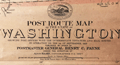 | Details | US Post Office Department | 1903 |
| Rare Post Route Map of the State of Washington |
|
US Post Office Department |
|
| 1903 |
| LOC:0 |
| $1,500.00 | US-Post-Office-Department | Rare-Post-Route-Map-of-the-State-of-Washington | Rare official U.S. Postal Service map of Washington State, complete with an oval vignette of a Pony Express rider and a steam locomotive with the motto of the US Post Office--"with Celerity, Certainty and Security". A rolled map with no folds. Should frame brilliantly.
<br></br>
Legend at bottoms shows "Explanation of Mail Service." keyed to colored lines on the map showing frequency of delivery. Also noted are railroads, beginning and end of delivery routes, mail messenger routes, Post Offices, discontinued Post Offices, and rural free delivery (RFD) routes.
<br></br>
Published September 1903 by order of Postmaster General Henry C. Payne, under the direction of A. von Haake, Topographer P.O. Department. |
| 1190 | 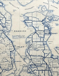 | Details | Davenport, Joseph B. | 1941 |
| Southern Districts of Vancouver Islands and Adjacent Gulf Islands |
|
Davenport, Joseph B. |
|
| 1941 |
| LOC:0 |
| $850.00 | Davenport--Joseph-B- | Southern-Districts-of-Vancouver-Islands-and-Adjacent-Gulf-Islands | Very large whiteprint or blue-line map of Southern Vancouver Island, British Columbia. First printed in 1932, this revised edition dates from 1941. Inset map of Saturna Island. Contains cadastral and road detail with a road index at center left. Laid to linen and on rollers; no folds.
<br></br>
Coverage includes Ladysmith, Duncan, Victoria, Sidney, portions of Juan de Fuca Strait, Strait of Georgia, Galiano Island, Mayne Island, North and South Pender Island, and numerous other islands and passages in that area.
<br></br>
Contains a red-stamped notation: "Pocket copies of this map may be obtained at the office--". Manuscript pencil course line and distances drawn from top of map near Kulleet Bay, through Stuart Channel and Haro Strait to Victoria Harbor.
<br></br>
Copyrighted in Canada 1932 by Joseph Davenport. Printed by the Island Blue Print and Map Company, Victoria, B.C. |
| 1060 |  | Details | Loots, Johannes | 1708 |
| Unrecorded Late Golden Age Dutch Sea Chart of the World |
|
Loots, Johannes |
|
| 1708 |
| LOC:0 |
| $95,000.00 | Loots--Johannes | Unrecorded-Late-Golden-Age-Dutch-Sea-Chart-of-the-World | Previously unrecorded nautical chart of the entire world by Dutch cartographer Johannes Loots. Not recorded in Koeman's Atlantes Neerlandici. Not found online. Not in AMPR.
<br></br>
Likely the only Dutch late Golden-Age unrecorded world nautical chart to surface in the 21st century. Differs from other sea charts of the period in that Loots places van Diemen's Land much farther east (13 degrees) than the others (Robijn, Roggeveen, Goos, Morden, Keulen, Wit, Doncker, Moxon, Halley) all of whom tend to place van Diemen's Land at the longitude of the west coast of the Cape York Peninsula (de Fer an exception). One possible explanation for the mis-alignment is that Hendrik Doncker never included van Diemen's Land on his charts, and as Doncker's apprentice, Loots was never required to deal with that area.
<br></br>
Covers the entire world. Loot's newly-discovered chart with title cartouche in four languages (1) Is the only known example of any world chart by Loots. (2) Is of a unique design found in no other world chart. (3) Includes tracks of explorers in the southern passage up to 1708, include le Maire, Schouten, Halley and "Vaisseau St. Louis, 1708" the last, just one year after Loots disolved a partnership with Antoni de Winter and Claas de Vries. (4) Is on Mercator's projection. (5) Shows the “Terre Austral du St. Espirit”.
<br></br>
From Koeman's biography of Johanne's Loots (1665[6]-1726) we know Loots was born in Amsterdam and is not as is sometimes believed one of the two sons of Anthonie (Theunisz) Jacobsz who named themselves Lootsman to confuse cartographic researchers in future centuries. Loots served an apprenticeship under Hendrick Doncker .
<br></br>
Contact for price. |