| | Thumbnail | | Creator | Date | Title / Author / Date / Location | Price | | | Description |
| 6803 | 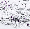 | Details | British Admiralty Hydrographical Office | 1974 |
| Original Admiralty Nautical Chart of Providence Island, Bahamas |
|
British Admiralty Hydrographical Office |
|
| 1974 |
| LOC: |
| $255.00 | British-Admiralty-Hydrographical-Office | Original-Admiralty-Nautical-Chart-of-Providence-Island--Bahamas | A fine British Admiralty nautical chart of the Bahamas Island of New Providence, first published in August, 1843. Retains the look of a mid-19th century copper-engraved sea chart. Admiralty chart # 1489.
<br><br>
At top of chart is a coastal elevation view of the Town of Nassau, on the Island of New Providence, from a distance offshore.
<br><br>
This item is the sixth edition of 1914 with corrections to 1974. |
| 6771 |  | Details | Touanne, Edmund Bigot de la | 1837 |
| Bougainville elevation views Port Jackson Rio de Janiero Da Nang Hainan Macao |
|
Touanne, Edmund Bigot de la |
|
| 1837 |
| LOC:130 |
| $800.00 | Touanne--Edmund-Bigot-de-la | Bougainville-elevation-views-Port-Jackson-Rio-de-Janiero-Da-Nang-Hainan-Macao | Sheet of coastal elevation views after drawings by Edmund Bigot de la Touanne (1796-1863) and engraved by Ambroise Tardieu (1) for "Journal de la navigation autour du globe de la Fregate la Thetis et de la corvette l 'Esperance." That journal documents the circumnavigation of Bougainville (2) during 1824 through 1826 aboard the Thetis and Esperance.
<br><br>
Plate 54. 1837.
<br><br>
The coasts depicted include the Philippine Island of Luzon; Guangzhou (Canton) China; Macao, China; Hainan, China; Da Nang, Vietnam; Lombok, Indonesia; Surabaya, Indonesia; Sydney, Australia; and Rio de Janeiro, Brazil. Descriptions of the views are translated here from the original text in French:
<div class="indenttextblocksingle">
<ul style="list-style-type: decimal;">
<li>Vue d'une partie de la cote Nord-Ouest de I'lle Lucon (Philippines) prise le 20 Decembre 1824</li>
<li>Vues de Piedra Branca a l'atterage du Golfe de Canton (Chine) prises le 24 December 1824</li>
<li>Vue du passage de Lantao a l'entree du Golfe de Canton (Chine) prises le 24 December 1824</li>
<li>Vue de la Ville de Macao (Chine) prises en Janvier 1825</li>
<li>Vue d'une partie de la cote est de I'lle d'Hainan (Chine) prises le 10 Janvier 1825</li>
<li>Vue de l'Entree de la Baie de Tourane (Cochinchine) prise le a Janvier 1825</li>
<li>Vue du Mouillage de Tourane (Cochinchine) prise en Fevrier 1825</li>
<li>Vue de I'lle Lombock (Archipel de al Sonde) prise le 10 Mai 1825</li>
<li>Vue de la Rade de Sourabaya a l'est de Java (Archipel de la Sonde) prise en Avril 1825</li>
<li>Vu de la Ville de Sidney au Port Jackson (Nouvelle Galles Meridionale) prise en Aout 1825</li>
<li>Vue de l'Entrée de la Baie de Rio Janeiro(Bresil) prise le Avril 1828.</li>
</ul>
</div> |
| 6698 | 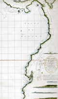 | Details | Direccion Hidrografia | 1800 |
| Rare Spanish chart of northwest South America exploration |
|
Direccion Hidrografia |
|
| 1800 |
| LOC:68 |
| $1,800.00 | Direccion-Hidrografia | Rare-Spanish-chart-of-northwest-South-America-exploration | A scarce, finely engraved original nautical chart of the northwest coast of South America from 1800. With the logo of the Deposito Hidrografico. Shows the tracks of Malaspina aboard the Descubierta and Atrevida (1). In the area of Ecuador the map is overlaid with the lines of the triangulation survey of La Condamine (2). Engraved by Fernando Selma. Dedicated to Don Antonio Cornel.
<br><br>
Shows the erupting volcano "Sangay" in Ecuador's eastern cordillera near to La Condamine's survey location.
<br><br>
(1) Malaspina Expedition - a voyage of scientific exploration sponsored by the Spanish government in the late 18th century. Led by Alejandro Malaspina the expedition set sail in 1789 with the aim of exploring and mapping the coasts of South America, Alaska, and the Philippines. The expedition included scientists, cartographers, and artists, and was one of the most extensive scientific expeditions of its time.
<br><br>
(2) Charles Marie de La Condamine was a French geographer, mathematician, and explorer who lived from 1701 to 1774. La Condamine conducted a triangulation survey near Quito, Ecuador and other locations during his expedition to South America. His goal was to measure the length of a degree of arc at the equator, which helped to confirm the shape of the Earth as an oblate spheroid. La Condamine also made important contributions to the study of Amazonian geography and culture, and he was one of the first Europeans to provide a detailed account of rubber. |
| 6552 |  | Details | British Admiralty Hydrographical Office | 1978 |
| Admiralty Chart Baja California Sea of Cortez with Cabo San Lucas |
|
British Admiralty Hydrographical Office |
|
| 1978 |
| LOC:0 |
| $500.00 | British-Admiralty-Hydrographical-Office | Admiralty-Chart-Baja-California-Sea-of-Cortez-with-Cabo-San-Lucas | Original later issue of a British Admiralty nautical chart first engraved and published in London at the Admiralty on April 9, 1879, under the superintendence of Royal Navy Hydrographer Captain F.J. Evans and updated with corrections. Last corrected in 1978.
<br></br>
Coverage on this fine Admiralty nautical chart includes the entire Baja Peninsula and Gulf of California (Sea of Cortez) from San Diego, California to Cabo San Lucas, Mexico.
<br></br>
Numerous well-known fishing spots are noted including: San Jaime Bank, Golden Gate Bank, Outer Gorda Bank, Finger Bank, and Morgan Bank. Two inset profiles of Cabo San Lucas.
<br></br>
Bold, dark, lithographed print retains the cartographic look and style of the late 19th century. Original engraving was executed by Davies and Company. Logo of the British Hydrographical Office at top of the title block. Chart Number 2324. Crown copyright reserved. |
| 6435 | 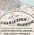 | Details | Weiss, Jacob | 1861 |
| Map of Charleston Harbor |
|
Weiss, Jacob |
|
| 1861 |
| LOC:10 |
| $2,150.00 | Weiss--Jacob | Map-of-Charleston-Harbor | Unrecorded edition of "Map of Charleston Harbor [South Carolina] showing the location of forts ..." printed by Jacob Weiss at 600 Chestnut Street, Philadelphia in 1861. Inset elevation or perspective view of Charleston at top.
<br><br>
My interpretation of the map suggests Weiss printed the map between December 27, 1860, when the Union surrendered Shutes Folly/Castle Pinckney to the S.C. militia but before April 12, 1861 when the Confederacy began bombardment of Union forces at Fort Sumter. During this period the public had an intense interest in the building conflict.
<br><br>
Shows the main channel from the Atlantic Ocean to Charleston docks. Circles represent the range of cannon fire from forts and batteries in vicinity of Charleston Harbor, Charleston, South Carolina. Key features include:
<div class="indenttextblocksingle">
<ul style="list-style-type: circle;"></li>
<li>Shutes Folly Island with Castle Pinckney</li>
<li>Rebellion Road [2]</li>
<li>US Arsenal</li>
<li>Customs House</li>
<li>Mount Pleasant</li>
<li>Sullivan's Island</li>
<li>Drunken Dick Breakers</li>
<li>Fort Johnson and Fort Sumter</li>
</ul>
</div>
WorldCat shows only two similar institutional holdings - Hagley Museum & Library, and University of Michigan Clements Library. This edition is similar to the edition at the U. Michigan Clements Library but lacks the price, and the Clements copy lacks both the decorative border, and the "Perspective View of the Harbor and City of Charleston" at top.
<br><br> |
| 5306 | 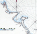 | Details | Mannevillette, d'Apres | 1775 |
| Rare French charts of Vietnam Coast including Da Nang |
|
Mannevillette, d'Apres |
|
| 1775 |
| LOC:9 |
| $475.00 | Mannevillette--d-Apres | Rare-French-charts-of-Vietnam-Coast-including-Da-Nang | Two original antique engraved charts on a single sheet: the Con Son Island Archipelago and Da Nang Bay including the Vietnam coast between the towns of Hue and Da Nang: "Plan de l'Isle Condor"; "Carte d'une Partie de la Cote de Cochinchine".
<br></br>
Includes three fine inset coastal elevation views:
<div class="indenttextblocksingle">
<ul style="list-style-type: circle;">
<li>Vue de l'Isle Champello ou Cham Collao.</li>
<li>Vue de l'entrée de la Baye de Touranne (Da Nang was known as Tourane during the French colonial period)</li>
<li>Vue de l'Isle Condor lorsque la Havre...</li>
</ul>
</div>
From J. B. d'Apres de Mannevillette's sea atlas "Le Neptune Oriental ou routier general des Cotes des Indes orientales et de la Chine." Jean-Baptiste d'Après de Mannevillette (1707 - 1780) was a French sailor, navigator, and hydrographer active in the mid-18th century. Mannevillette studied mathematics and navigation in Paris before winning a commission as an officer on a merchant vessel headed for the West Indies. Mannevillette collected and revised a number of regional nautical charts during numerous voyages around Africa to India and China.
The Compagnie des Indes (French East India Company) appointed D'Apres de Mannevillette as director of maps and plans at Lorient in 1752. |
| 5019 |  | Details | Canadian Pacific Railroad | 1941 |
| Map of Banff Lake Louise Columbia Icefield Highway Glaciers |
|
Canadian Pacific Railroad |
|
| 1941 |
| LOC:10 |
| $350.00 | Canadian-Pacific-Railroad | Map-of-Banff-Lake-Louise-Columbia-Icefield-Highway-Glaciers | Attractive and very scarce lithographed map of Banff, Lake Louise and the Columbia Icefield Highway with the Yoho Valley Emerald Lake Field, and Golden, Canada. Shows highways, glaciers, mountain ranges, trails, and the route of the Canadian Pacific Railway.
<br></br>
Map is on the recto of a folding six-part brochure with an inset elevation view of the "Altitudes of principal peaks from Golden to Banff in the Canadian Rockies." In that view the peaks with names underlined are on the South Side of the Canadian Pacific Railway main line from Banff to Golden.
<br></br>
Verso contains photographs, text and a map of the Columbia Icefield Highway (Sunwapta Pass to Lake Louise) and a cross section (elevation view) of the Canadian Rockies from the same Columbia Icefield Highway. Dated by reference to the Rumsey Collection. |
| 858 | 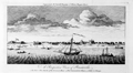 | Details | Universal Magazine | 1764 |
| Antique engraved elevation view of Pensacola, Florida |
|
Universal Magazine |
|
| 1764 |
| LOC:3 |
| $360.00 | Universal-Magazine | Antique-engraved-elevation-view-of-Pensacola--Florida | Antique elevation view of Pensacola, Florida and the very few structures that existed 250 years ago just after the end of Spanish rule over the city. A legend at bottom is keyed to six locations on the view including: 1. The Fort. 2. The Church. 3. The Governor's House. 4. The Commandant's House. 5. A Well. 6. A Bungo. (A bungo was a type of boat or canoe used in the southern United States made of a hollowed-out tree.)
<br></br>
This engraving is the earliest available printed view of Pensacola and comes from the January 1764 issue of the Universal Magazine. After Dominic Serres (1719-1793), a French-born painter primarily of nautical or maritime subjects. Serres was assigned to the British expedition to capture Havana, led by Admiral Sir George Pocock. It is possible that Serres visited Pensacola during that cruise. |
| 834 | 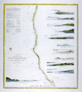 | Details | U.S. Coast and Geodetic Survey | 1869 |
| Western Coast of U.S. from San Francisco to Umpquah (Umpqua) River |
|
U.S. Coast and Geodetic Survey |
|
| 1869 |
| LOC:63 |
| $675.00 | U-S--Coast-and-Geodetic-Survey | Western-Coast-of-U-S--from-San-Francisco-to-Umpquah-(Umpqua)-River | Very attractive antique nautical chart of the <b>western coast of California</b> focused on the Pacific coastline between <b>San Francisco, California</b> and the Umpqua River, Oregon. This scarce, rolled, separately issued chart, corrected to 1869, was first published in 1854 by the U.S. Coast Survey. Noted habitations and geographical features include Empire City, Koos Bay, and Port Orford or Ewing Harbor, Oregon; Crescent City, Reddings Rock, Eureka, Mendocino City, Haven's Anchorage, Bodega Bay, Pt. Reyes, Alcatraz Island, Oakland, Alameda, Union City and San Francisco Bay, California. Numerous soundings, navigational hazards, and aids to navigation are identified.
<br></br>
This antique sea chart is enlivened with twelve attractive hand-colored <b>inset coastal elevation views</b> including: the Entrance to San Francisco Bay, Point Arena, Mendocino City Cove, Trinidad Head and City, Cape Mendocino, Red Bluff Entrance to Humboldt Bay, Point St. George, Mack's Arch and Reef, Rogues River, Cape Blanco, and Cape Gregory.
<br></br>
This is a scarce, separately issued, rolled nautical chart of the U.S. West Coast, not the more common folded version on thin paper that was issued with other charts in an annual report to Congress from the Coast Survey.
<br></br>
This chart was printed in 1869 from an electrotype-printed copy of the original hand-engraved copper plate. Electrotype printing is a process the U.S. Coast Survey adopted around 1850. As a soft medium, copper plates could only withstand print runs of perhaps 200 copies before the plates wore down. To enable larger print runs, a mold of the original plate was created in wax or another soft medium. Then, using an electro-chemical process ( electrotyping ), the mold was coated with a metal layer, typically copper. Printers were then able to produce output from the new electrotype copper copy, while preserving the original. Electrotype copy no. 6 by Mathiot. |
| 116 |  | Details | Collins, Greenvile | 1750 |
| How the Several Lands Show at Sea |
|
Collins, Greenvile |
|
| 1750 |
| LOC:0 |
| $135.00 | Collins--Greenvile | How-the-Several-Lands-Show-at-Sea | Antique nautical profile views of English coast including Beachy Head, Portland, Isle of Wight, Dartmouth, and Milford. This scarce nautical engraving accompanied other nautical charts from one of the many editions of Great Britain's Coasting Pilot by Greenville Collins. |