| | Thumbnail | | Creator | Date | Title / Author / Date / Location | Price | | | Description |
| 111 |  | Details | Morisot, C.B. | 1643 |
| Antiqua Triremis Nova Triremis |
|
Morisot, C.B. |
|
| 1643 |
| LOC:0 |
| $0.00 | Morisot--C-B- | Antiqua-Triremis-Nova-Triremis | <BR> </BR>
SOLD
<BR> </BR>
Single sheet of chain laid paper with two engraved illustrations from the first comprehensive work on maritime history by Charles Barthelemy Morisot- "Orbis Maritimi siue Rerum". First is titled "Antiqua Triremis" and shows a small galley in an ancient style (6 1/2" x 5 1/2"). On the obverse is an engraving of a 'modern' trireme "Nova Triremis quam dicimus, Galere" (6 1/2" x 6 1/2"). The depiction of this two masted 'nova' galley is noteworthy for its plan of the oarsmen's seating and 'alla scaloccio' rowing arrangement with four men to one oar. From "Orbis Maritimi siue Rerum in Mari et Littoribus Gestarum Generalis Historia". |
| 1177 | 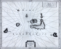 | Details | Aa, Pieter van der | 1719 |
| Antique map of the Banda Islands, Indonesia |
|
Aa, Pieter van der |
|
| 1719 |
| LOC:9 |
| $880.00 | Aa--Pieter-van-der | Antique-map-of-the-Banda-Islands--Indonesia | Rare Dutch map / chart of the Banda Islands, part of the Indonesian province of Maluku, comprising the important Spice Islands. The Banda Islands are part of the Moluccas archipelago to the west of New Guinea. Until the mid-19th century the Banda Islands were the world's only source of the spices nutmeg and mace, produced from the nutmeg tree.
<br></br>
Pieter van der Aa (1659 - 1733) was a Dutch publisher working in Leiden during the early eighteenth century. He is best known for publishing maps and atlases, though he also printed pirated editions of foreign bestsellers and illustrated volumes. From "Nouvel atlas...contenant les principales cartes géographiques dressées suivant les nouvelles observations de Mr. de l'Académie royale des sciences" published in 1714 from Leiden by Van der Aa. Plate number 27 (in manuscript).
<br></br>
Printed on a large sheet measuring 19" W x 15" H. |
| 1191 |  | Details | Aa, Pieter van der | 1719 |
| Antique City Plan of Batavia or Jakarta, Indonesia |
|
Aa, Pieter van der |
|
| 1719 |
| LOC:9 |
| $365.00 | Aa--Pieter-van-der | Antique-City-Plan-of-Batavia-or-Jakarta--Indonesia | Antique Dutch map of the village of "Batavia" or Jakarta, Indonesia. Jakarta was the de facto capital of the Dutch East Indies, formed from the nationalized colonies of the Dutch East India Company (VOC), which came under the administration of the Dutch government in 1800.
<br></br>
Forty-one notable locations are identified numerically on this fine copper-plate engraved plan and are explained in a large table at bottom right. These important locations include defensive positions, churches, and maritime related sites such as:
<div class="indenttextblock">
<ul style="list-style-type: circle;">
<li>le Fort</li>
<li>Redoute d' Amsterdam</li>
<li>Bastion le Saphir</li>
<li>Reduit de Nassau</li>
<li>le Werf Place aux Ancres</li>
<li>Grande Riviere</li>
<li>le Canal</li>
<li>l'Eglise des Portugais</li>
<li>Marche au poissons</li>
<li>le Hospital</li>
</ul>
</div>
On a much larger sheet of antique chain-laid paper measuring 19" W x 15" H.
<br></br>
Pieter van der Aa (1659 - 1733) was a Dutch publisher working in Leiden during the early eighteenth century. He is best known for publishing maps and atlases, though he also printed pirated editions of foreign bestsellers and illustrated volumes. From "Nouvel atlas...contenant les principales cartes géographiques dressées suivant les nouvelles observations de Mr. de l'Académie royale des sciences" published in 1714 from Leiden by Van der Aa. Plate number or notation in manuscript at bottom left. |
| 648 | 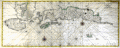 | Details | Valentijn, Francois | 1720 |
| Amboina, Seram, and Malaku Islands |
|
Valentijn, Francois |
|
| 1720 |
| LOC:0 |
| $880.00 | Valentijn--Francois | Amboina--Seram--and-Malaku-Islands | Scarce antique Dutch chart of part of the Maluku (Molucca) island chain in Indonesia (the Spice Islands). Includes Buru Island ( Boero ), Amboin, Seram (Ceram) , Banda, and many other smaller islands. The chart is comprised of two conjoined sheets making up the seldom available 29" wide chart of the region. On watermarked chain-laid paper.
<br></br>
From François Valentyn's Oud en Nieuw Oost Indien (Old and New East India), part V : Beschryving van Coromandel, Pegu, Arrakan, Bengale, Mocha, Persien, Malakka, Sumatra, Ceylon. François Valentijn (1666-1727) was a missionary who worked at Amboina from during the late 17th and early 18th centuries. With numerous rhumb lines and two compass roses topped with fleur-de-lis. Plate 1. |
| 1433 | 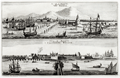 | Details | Aa, Pieter van der | 1725 |
| Scarce antique views of Batavia or Jakarta, Indonesia |
|
Aa, Pieter van der |
|
| 1725 |
| LOC:9 |
| $500.00 | Aa--Pieter-van-der | Scarce-antique-views-of-Batavia-or-Jakarta--Indonesia | Two fine antique copperplate-engraved views of Batavia (Jakarta, Indonesia), capital of the Dutch East Indies. One early view "La Ville de Batavie" with city structures in the background, shows the shallow channel to the inner harbor marked by pilings, with shallow-draft vessels plying the waters. Further off-shore deeper-draft, square-rigged sailing ships are drawn at anchor and tied to tall above-water structures we today would describe as pilings with cribbing. Excellent quality engravings.
<br></br>
The second view "Chateau de Batavia" presents a square-shaped fortress equipped with four protruding bastions made of solid earthen walls and coral with a strong wooden palisade. Batavia Castle was the administrative center of the Dutch East India Company (VOC) in Asia. Batavia Castle housed the administration buildings of the VOC, including the Governor-General's residence, residences for high officials, workshops, a treasury, a prison, storehouses and the meeting hall of the council of the Indies.
<br></br>
Batavia corresponds to the present city of Jakarta, Indonesia. Batavia was founded as the trade and administrative center of the Dutch East India Company and within Batavia's walls, the wealthy Dutch built tall houses and canals.
<br></br>
Published from Leiden by Pieter van der Aa.
<br></br>
Pieter van der Aa (1659 - 1733) was a Dutch publisher working in Leiden during the early eighteenth century. He is best known for publishing maps and atlases, though he also printed pirated editions of foreign bestsellers and illustrated volumes. From "La Galerie Agreable du Monde. Tome premier des Indes Orientales" published in 1725 from Leiden by Van der Aa. This plate was originally published in 'Gezandtschap der Nederlandtsche Oost-Indische Compagnie ...' by J. Nieuhof. |
| 506 | 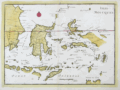 | Details | Le Rouge, George | 1767 |
| Isles Moluques |
|
Le Rouge, George |
|
| 1767 |
| LOC:6 |
| $185.00 | Le-Rouge--George | Isles-Moluques | Antique map of the Moluccas (Malaku Islands) in Asia, an archipelago within Indonesia. These islands were once referred to as the "Spice Islands". Plate 82. Coverage includes Bali, Borneo, Sulawesi (Celebes Isle) , East Java, Timor, Ambon, Ceram, and Western New Guinea. |
| 798 |  | Details | Mannevillette, d'Apres | 1775 |
| Antique chart of the Strait of Bali with Madura and Java |
|
Mannevillette, d'Apres |
|
| 1775 |
| LOC:9 |
| $550.00 | Mannevillette--d-Apres | Antique-chart-of-the-Strait-of-Bali-with-Madura-and-Java | Antique French nautical chart of the Bali Strait with Java to the left and Bali at right and the Island of Madura at top. This attractive 1775 sea chart contains an inset plan of Banyuwangi Bay ("Baye de Ballambouang") and three inset profile coastal views of the headlands surrounding the Bali Strait.
<br></br>
Key points of interest include Buleleng ("Bollilingh"), Bali; the Madura Strait; Sumenep, Madura; Palau Puteran; Palau Gili Iyang; Palau Sapudi ("Isle Galioen ou Respondi"); Palau Raas ("Isle de Entrepot").
<br></br>
The chart is based on exploration and observations aboard several vessels: France's "Elephant", and several British ships including the 29 gun East Indiaman "Winchelsea" commanded by Thomas Howe. Number 45.
<br></br>
By Jean-Baptiste d'Après de Mannevillette (1707 - 1780) a French sailor, navigator, and hydrographer active in the mid-18th century. Mannevillette studied mathematics and navigation in Paris before winning a commission as an officer on the merchant headed for the West Indies. Mannevillette collected and revised a number of regional nautical charts during numerous voyages around Africa to India and China. |
| 1206 | 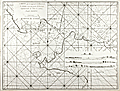 | Details | Mannevillette, d'Apres | 1775 |
| Chart of the Sunda Strait between Sumatra and Java |
|
Mannevillette, d'Apres |
|
| 1775 |
| LOC:59 |
| $0.00 | Mannevillette--d-Apres | Chart-of-the-Sunda-Strait-between-Sumatra-and-Java | SOLD
<br></br>
Fine original 18th century French nautical chart of the Sunda Strait ("Detroit de la Sonde") with Jakarta, Indonesia (Batavia) at extreme right. Very rare, no record of any sale of this chart is found in the AMPR, nor is any holding found online.
<br></br>
The Sunda Strait is a narrow waterway connecting the Java Sea to the Indian Ocean. Includes the Indonesian islands of Sumatra and Java. With four attractive inset elevation views of Sunda Strait and coast as seen from offshore. Numerous depth soundings and place names are provided. Engraved by Dheulland.
<br></br>
From J. B. d'Apres de Mannevillette's sea atlas "Le Neptune Oriental ou routier general des Cotes des Indes orientales et de la Chine." Jean-Baptiste d'Après de Mannevillette (1707 - 1780) was a French sailor, navigator, and hydrographer active in the mid-18th century. Mannevillette studied mathematics and navigation in Paris before winning a commission as an officer on a merchant vessel headed for the West Indies. Mannevillette collected and revised a number of regional nautical charts during numerous voyages around Africa to India and China.
<br></br>
Antique copper-engraving, published in Paris, ca. 1775. No folds. |
| 6491 | 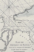 | Details | Mannevillette, d'Apres | 1775 |
| Antique nautical chart of the Bangka or Banca Strait |
|
Mannevillette, d'Apres |
|
| 1775 |
| LOC:90 |
| $250.00 | Mannevillette--d-Apres | Antique-nautical-chart-of-the-Bangka-or-Banca-Strait | Antique nautical chart of the Detroit du Banca or Bangka Strait from 1775 by Jean-Baptiste-Nicolas-Denis D’ Après de Mannevillette (1707 – 1780). Inset chart of a smaller strait between the Isle de Sel and part of Biliton Island or Belitung Island. That strait lies approximately 70 miles to the east of south Bangka Island.
<br><br>
The map is particularly interesting historically as it incorporates paste-over corrections to the eastern portion of the Isle de Banca with the previously charted coastline still faintly visible beneath the corrections. According to a pasted note at bottom left, the pasted corrections to the northeast of Bangka Island were based on the observations of M. Crozet. Julien Crozet was second in command during the French expedition of Marion De Fresne to Tasmania, New Zealand, and the South Pacific, sailing in 1771. Crozet assumed command of the expedition after the voyage's commander, Marion De Fresne, and 26 crew members were killed by the Maori Ngare Raumati tribe off the coast of New Zealand in June 1772.
<br><br>
Bangka Strait is the narrow body of water that separates the island of Sumatra from the Indonesian island of Bangka. Bangka is one of the world's most important tin-producing areas. |
| 4873 | 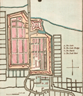 | Details | Luffman, John | 1802 |
| Antique map of Batavia |
|
Luffman, John |
|
| 1802 |
| LOC:77 |
| $280.00 | Luffman--John | Antique-map-of-Batavia | Antique map of Batavia (Jakarta, Indonesia) by John Luffman. |
| 800 | 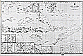 | Details | British Admiralty Hydrographical Office | 1864 |
| Chart of South Sulawesi and Lesser Sunda Islands from Bali to Timor |
|
British Admiralty Hydrographical Office |
|
| 1864 |
| LOC:59 |
| $1,075.00 | British-Admiralty-Hydrographical-Office | Chart-of-South-Sulawesi-and-Lesser-Sunda-Islands-from-Bali-to-Timor | Antique British Admiralty navigational chart of a major portion of the Lesser Sunda Islands. Coverage includes the Strait of Macassar, Gulf of Boni, Banda Sea, Arafura Sea, the lower portion of Sulawesi, Indonesia ( Celebes ) , and the islands of Bali ( Baly ), Lombok, Sombawa, Comodo, Flores, and Timor. <br></br>
This fine large chart Includes 9 inset detailed charts at bottom left: Anapanam Bay, Laboaen Tring Bay, Pampang Bay, Pidioe Bay, Taliwang Bay, Bima Bay, Sapie Bay, Nangamessie Bay, Koepang Bay.
<br></br>
Published at the Hydrographic Office of the Admiralty August 4, 1851 with last corrections in 1864. Originally sold by J.D. Potter, London. Bottom margin includes a small pasted seller's label from Australia: "Blundell & Ford, Admiralty Chart Agents. Melbourne". Number 2073. |
| 871 | 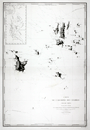 | Details | Depot de la Marine | 1878 |
| Chart of the Anambas Archipelago of Indonesia in the South China Sea |
|
Depot de la Marine |
|
| 1878 |
| LOC:0 |
| $0.00 | Depot-de-la-Marine | Chart-of-the-Anambas-Archipelago-of-Indonesia-in-the-South-China-Sea | SOLD
<br></br>
Scarce chart of the Anambas Islands of Indonesia found in the South China Sea between the Malaysian mainland to the west and the island of Borneo to the east. This antique French nautical chart published in 1878 is based on the exploration conducted aboard the French Frigate 'la Favorite' during March and April 1831 by Captain Cyrille Pierre Théodore Laplace. Major islands shown on the chart include Pulau Jemaja, Pulau Telaga, Pulau Siantan, Pulau Siantan, Pulau Bajau, Pulau Mubur, and Pulau Matak.
<br></br>
Contains a detailed inset at upper right of the tracks of earlier exploration in 1825 by Du Camper aboard the l'Esperance and Bougainville on la Thetis. |
| 1277 | 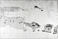 | Details | Depot de la Marine | 1880 |
| Antique chart of East Java and the Madura Strait |
|
Depot de la Marine |
|
| 1880 |
| LOC:0 |
| $450.00 | Depot-de-la-Marine | Antique-chart-of-East-Java-and-the-Madura-Strait | Antique French sea chart of east Java, Indonesia with the Strait of Madura, Lombok, <b>Bali</b> (Baly), and the <b>Kangean Archipelago</B>. A very attractive, large and clean antique nautical chart with finely-engraved detailed togography.
<br></br>
This chart was first issued by France's Depot de la Marine in 1862 and re-issued here with corrections in 1880. After an earler chart by Lt. Swann of the Royal Maraine Hollandaise. |
| 873 | 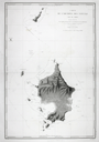 | Details | Depot de la Marine | 1888 |
| Chart of the Natuna Archipelago of Indonesia in the South China Sea |
|
Depot de la Marine |
|
| 1888 |
| LOC:0 |
| $0.00 | Depot-de-la-Marine | Chart-of-the-Natuna-Archipelago-of-Indonesia-in-the-South-China-Sea | SOLD<BR></BR>
Large antique French sea chart of the Natuna Island Archipelago located in the South China Sea about 300 miles northeast of Singapore. The Natuna Islands, off the northwest coast of Borneo are technically part of Indonesia although China has included them inside its nine-dash line, an area of the South China Sea within which it claims sovereignty to all the islands, atolls, and reefs. The claims of China are disputed by Indonesia, Vietnam, the Philippines and other countries.
<br></br>
With the route of the French corvette La Favorite during their exploration of the area in 1831. This edition of the chart dates to August 1888. Published by the Depot de la Marine, France's official Hydrographic Agency. |