| | Thumbnail | | Creator | Date | Title / Author / Date / Location | Price | | | Description |
| 1225 | 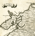 | Details | Popple, Henry | 1742 |
| Antique plan of the Harbor of Portobelo Panama |
|
Popple, Henry |
|
| 1742 |
| LOC:0 |
| $0.00 | Popple--Henry | Antique-plan-of-the-Harbor-of-Portobelo-Panama | SOLD
<br></br>
Scarce antique copper-plate engraved harbor plan of Portobelo, <b>Panama</b> (Portobello) after Henry Popple (1733). Popple's chart predates the later charts of Bellin and Bowen who based their geography on Durrell.
<br></br>
<b>Portobelo</b> was founded in March 1597 as "San Felipe de Portobelo". A military compound, Portobelo belonged to a larger defensive system, including Veracruz (Mexico), Cartagena (Colombia), and Havana (Cuba), to protect the route of commercial trade between the Americas and Spain. Portobelo, where the annual late summer trade fairs were held, was one of the principal Caribbean ports and played a leading role controlling Spain's imperial trade in the Americas. <a href="http://whc.unesco.org/en/list/135 " target="_blank"> Source. </a>
<br></br>
Key features named on the map include:
<div class="indenttextblock">
<ul style="list-style-type: circle;">
<li>Castilo de St. Goronimo ( San Geronimo Fort ) </li>
<li>Castilo de Fierro ( Actually the Castillo de Hierro or Iron Castle ) </li>
<li>Castilo de la Gloria ( Fort Santiago de Gloria )</li>
<li>Rio de Cascasal (Rio Cascaja)</li>
<li>Savanilla</li>
<li>Ferrelon de Duarte</li>
<li>Ferrelon Negro</li>
</ul>
</div>
This antique map was originally published by Covens and Mortier in 1742 in "Les Principales Forteresses Ports etc. de L'Amerique Septentrionale" a sheet containing harbor and island maps and plans of the Americas. This map is a fragment trimmed from the larger sheet.
<br></br>
That sheet of 18 maps and plans of islands and harbors was publihed by Covens and Mortier to replace Popple's original large map of 20 sheets with a more manageable six-sheet version. Popple's original map was titled: "A Map of the British Empire in America with the French, Spanish and the Dutch Settlements adjacent thereto". With depth soundings, anchorages, and navigation hazards. Notation by engraver at bottom right: I.K. f. |
| 3692 | 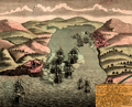 | Details | Homann Heirs | 1743 |
| Scarce antique view of Portobelo, Panama |
|
Homann Heirs |
|
| 1743 |
| LOC:77 |
| $225.00 | Homann-Heirs | Scarce-antique-view-of-Portobelo--Panama | Very scarce birds-eye view of Portobelo, Panama in Colon Province during its capture and destruction in 1739-1742 during the War of Jenkins' Ear. The map depicts the town of Portobelo, Fort Gloria, and the immediate vicinity, including the harbor and Fort Hierro (iron), constructed across the harbor from Portobelo. Several sailing ships depict a naval battle scene and notes in the title block identify and explain sixteen important locations and actions on the view.
<br></br>
Portobelo was founded in March 1597 as "San Felipe de Portobelo". A military compound, Portobelo belonged to a Spain's colonial defensive system, including Veracruz (Mexico), Cartagena (Colombia), and Havana (Cuba), to protect the route of commercial trade between the Americas and Spain. Portobelo, where the annual late summer trade fairs were held, was one of the principal Caribbean ports and played a leading role controlling Spain's imperial trade in the Americas.
<br></br>
Published by the firm Homann Heirs. Homann Heirs (also "Homannianis Heredibus" or "Homann Erben" or "Heritiers de Homann") was a company established after the death of German cartographer J.B. Homann to carry on the map publishing business of the firm he started in the early 1700's. The designation "Homann Heirs" appears on maps published by that successor firm from about 1730 to 1848. |
| 1088 | 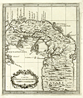 | Details | Coltellini, Marco | 1763 |
| Attractive antique map of the Isthmus of Panama |
|
Coltellini, Marco |
|
| 1763 |
| LOC:5 |
| $325.00 | Coltellini--Marco | Attractive-antique-map-of-the-Isthmus-of-Panama | Detailed and interesting antique (1763) engraved map of the Isthmus of Panama (Spanish: Istmo de Darien) showing interior detail and the Bay of Panama. Noted feautures include Portobelo ("Porto Bello"), Panama City, and Nuova Edinburg . New Edinburg was the site of the "Darien Scheme", a colony called "Caledonia" supported by the Kingdom of Scotland in the late 1690's. That unsuccessful colony was established by the Scottish Darien Company in an attempt to create a trading point between Europe and the Far East. The attempt was a disaster. When it failed the venture cost Scotland of an estimated quarter of its liquid assets and was an important factor in encouraging the country to the 1707 Act of Union which united the Kingdoms of Scotland and England.
<br></br>
The Gulf of Darién is the southernmost region of the Caribbean Sea, located north and east of the border between Panama and Colombia. Within the gulf is the Gulf of Urabá, a small lip of sea extending southward, between Caribana Point and Cape Tiburón, Colombia, on the southern shores of which is the port city of Turbo, Colombia.
<br></br>
Published from Livorno, Italy in 1763 in "Il Gazzettiere americano". |
| 1089 | 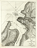 | Details | Coltellini, Marco | 1763 |
| Attractive antique plan of Chagres, Panama and Fort San Lorenzo |
|
Coltellini, Marco |
|
| 1763 |
| LOC:5 |
| $325.00 | Coltellini--Marco | Attractive-antique-plan-of-Chagres--Panama-and-Fort-San-Lorenzo | Finely engraved, antique (1763) port plan of Fort San Lorenzo and the town of Chagres, Panama on the north coast of Panama, now abandoned. Features include Chagres village, Castillo San Lorenzo, Forte della Punta, numerous depth soundings and a road labeled "Strado de Vento de Cruzes 56 miglia, e a Panama".
<br></br>
Spain's early trail to Panama City, the Las Cruces Trail, was reliant on the Chagres River for much of its route. Spain established Chagres at the mouth of the Chagres River, in the 16th century as a port for the purpose of loading its Peruvian plunder for trans-shipment to Nombre de Dios or Portobello where it would be consolidated and shipped onward to Spain. To protect the port, the Spanish established a fort, San Lorenzo, on a cliff overlooking the harbor.
<br></br>
Published from Livorno, Italy in 1763 in "Il Gazzettiere americano". |
| 5258 | 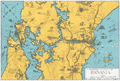 | Details | Goodrich, James J. | 1930 |
| Unrecorded Panoramic Pictorial Map of Panama |
|
Goodrich, James J. |
|
| 1930 |
| LOC:77 |
| $275.00 | Goodrich--James-J- | Unrecorded-Panoramic-Pictorial-Map-of-Panama | Unrecorded pictorial map of Panama by Corporal James J. Goodrich, 11th Engineers ca. 1930. Adorned with numerous idiosyncratic illustrations including at upper right a drawing of a panther labeled "Black Cats." Many illustrations of military aircraft and naval vessels. Dotted line north of the Panama Canal shows a "proposed highway across the isthmus" beginning at the Madden Dam, completed in 1935, and terminating at Colon on the Pacific Ocean.
<br></br>
The 11th Engineer battalion was activated on the 20th of November, 1920 in the Panama Canal Zone. The 11th engineers conducted numerous engineer missions over rugged terrain and through dense jungle. It was in Panama that the 11th adopted for its crest the Panama Black Panther and assumed the nickname "Jungle Cats." The 11th Engineers were relieved of their assignment to the Panama Canal Division in April, 1932. |