| | Thumbnail | | Creator | Date | Title / Author / Date / Location | Price | | | Description |
| 4829 | 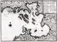 | Details | Laval, Antoine | 1728 |
| Rare early map of Fort Royal Bay, Martinique |
|
Laval, Antoine |
|
| 1728 |
| LOC:13 |
| $500.00 | Laval--Antoine | Rare-early-map-of-Fort-Royal-Bay--Martinique | Rare, earliest (1728) chart of the entirety of Fort de France Bay. By Father Antoine Laval. Laval's antique chart of Fort Royal, based on surveys of 1720, should be considered a foundational artifact for collectors of Caribbean Island cartography as it is the first detailed printed chart to cover the entire Baie de Fort de France on the island of Martinique. It was almost 35 years later when the next accurate harbors plans of the "Cul de Sac Royal" were printed by Bellin (1764) and by Caylus (1760).
<br></br>
This map was included in the report of French astronomer Father Antoine Laval: "Voyage de la Louisiane", an account of the 1720 expedition to the Florida and Louisiana coasts led by French officer Valette de Laudun. Laval is recorded as mathematician or astronomer on that voyage. Laval was a professor of hydrography and mathematics based in the city of Toulon, France. Page 48.
<br></br>
Vallette de Laudun led the French expedition to Dauphin Island in the Gulf of Mexico between March and November, 1720. The 262-member crew embarked from Toulon, France, on the ship Toulouse , encountering Madeira, Martinique, Saint-Domingue, and Cuba before entering the Gulf of Mexico. Following a month at Dauphin Island, the expedition returned to France. |
| 4811 |  | Details | Seutter, Albrecht Carl | 1730 |
| Fine antique map of Martinique in the Caribbean Sea |
|
Seutter, Albrecht Carl |
|
| 1730 |
| LOC:51 |
| $1,050.00 | Seutter--Albrecht-Carl | Fine-antique-map-of-Martinique-in-the-Caribbean-Sea | Beautiful original antique engraved map of the <b>Caribbean island of Martinique</b> ca. 1730. This is a map that has much to offer when viewed up close: wonderful topography with trees, mountains, roads, and rivers. Many important locations and structures are identified directly on the map, for example in the area around Fort de France Bay (Baye et Cul de Sac Royal): l'Hopital le Capucins, Morne Rouge, le Fort Royal St. Louis, le Cul de Sac a Vache, Notre Dame de Grace, and Café des Navires.
<br></br>
Discovered by Columbus in 1493, he landed there in 1502 and named the island Martinica. Martinique was a French colony from 1635-1946 when it became the French Overseas Department of Martinique.
<br></br>
Fine decorative cartouche with Mercury, god of Commerce, hovering above and Poseidon below while half-clothed Native Americans are shown trading with Europeans. Title reads: "Representation la plus nouvelle et exacte de l'Ile Martinique, la premiere des Iles del' Amerique Antilles nommees Barlovento, aux depens de Matthieu Seutter , graveur de cartes geograph de S.M.I. a Augsbourg."
<br></br>
Top of the map with an interesting Avertissement in French and German "Pour rendre cette Carte a l'usage des Navigateurs…des Marques" or an explantion of symbols used on the map that would be useful to navigators including water mills ("moulins a eau"), anchorages for small boats ("mouillage pour les petits batimens"), and sugar mills ("sucrerie"). Some of the more heavily traveled bays show depth soundings and below-water navigational hazards. |
| 1439 | 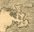 | Details | Popple, Henry | 1742 |
| Antique plan Fort-de-France Bay on Martinique, France Caribbean |
|
Popple, Henry |
|
| 1742 |
| LOC:41 |
| $85.00 | Popple--Henry | Antique-plan-Fort-de-France-Bay-on-Martinique--France-Caribbean | Antique chart fragment ca. 1742 of Baie de Fort-de-France or Fort-de-France Bay on the west side of the Island of Martinique, an overseas region of France. Includes Fort-de-France (Fort Royal). With soundings and sand banks delineated. Key locations named on the map include Flemish Bay, Grand and Petit Islets, Ramieres or Ramiers Ilet, and Cul de Sac au Hay.
<br></br>
This antique map was originally published by Covens and Mortier in 1742 in "Les Principales Forteresses Ports etc. de L'Amerique Septentrionale" a sheet containing harbor and island maps and plans of the Americas. This map is a fragment trimmed from the larger sheet.
<br></br>
That sheet of 18 maps and plans of islands and harbors was published by Covens and Mortier to replace Popple's original large map of 20 sheets with a more manageable six-sheet version. Popple's original map was titled: "A Map of the British Empire in America with the French, Spanish and the Dutch Settlements adjacent thereto". |
| 3594 | 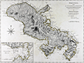 | Details | Jefferys, Thomas | 1775 |
| Antique nautical chart of Martinique West-India Atlas Jefferys Sayer |
|
Jefferys, Thomas |
|
| 1775 |
| LOC:0 |
| $900.00 | Jefferys--Thomas | Antique-nautical-chart-of-Martinique-West-India-Atlas-Jefferys-Sayer | Fine, very desirable chart of Martinique (Martinico) in the Caribbean Sea. A beautiful British-published chart based on hydrographic surveys by English engineers before 1775. Inset port plan of Cul de Sac Royal or Fort de France Bay.
<br></br>
The chart is from the scarce <b>first issue of 1775 by Sayer</b>, the other issues being 1781, 1787, 1794, 1796, 1807, and 1818 published by Sayer and then Laurie and Whittle. <a href="https://www.davidrumsey.com/home" target="_blank">(Online).</a>
Publishers attribution reads: "London. Printed for Rob.t Sayer, Map and Printseller. No 53 in Fleet Street as the Act directs 20th Feb.y 1775.
<br></br>
From: "The West-India Atlas: or, A Compendious Description of the West-Indies: illustrated with Forty Correct Charts and Maps, taken from Actual Surveys. Together with An Historical Account of the Several Countries and Islands which compose that part of the world. Their Discovery, Situation, Extent, Boundaries, Product, Trade, Inhabitants, Strength, Government, Religion, &c."
Authors: Gerard van Keulen, Thomas Jefferys.
Publishers: Robert Sayer.
Jefferys died in 1771; Sayer acquired Jefferys' materials in preparation for this atlas, and published the atlas posthumously under his name. |
| 260 | 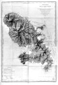 | Details | Monnier, Paul | 1893 |
| Carte Generale de la Martinique |
|
Monnier, Paul |
|
| 1893 |
| LOC:51 |
| $375.00 | Monnier--Paul | Carte-Generale-de-la-Martinique | Striking, antique sea chart / map of the island of Martinique, an overseas region of France, in the eastern Caribbean. This large chart is an 1877 edition of a chart first produced in 1831 by Monnier for France's Depot de la Marine, printed with corrections in 1893. . The chart is a fine example of the extensive use of hachuring to convey interior details of the island. <br></br>
Lighthouses dotted in yellow. Contains the circular seal for the Depot General de la Marine . |