| | Thumbnail | | Creator | Date | Title / Author / Date / Location | Price | | | Description |
| 1037 | 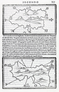 | Details | Bordone, Benedetto | 1534 |
| Early maps of the Greek Cycladic islands of Tinos and Andros |
|
Bordone, Benedetto |
|
| 1534 |
| LOC:2 |
| $0.00 | Bordone--Benedetto | Early-maps-of-the-Greek-Cycladic-islands-of-Tinos-and-Andros | SOLD<br><br>One of the earliest printed maps of the Greek islands of Tinos and Andros, both located in the northern Cyclades archipelago. Two maps on a single page. The map of Andros shows a fortified Andros town perched on a peninsula at the western side of the island.
<br></br>
Published from Venice in 1534 in the second edition of Benedetto di Bordone's 'Isolario', or "Island Book". The various editions of the Isolario were published using the same wood-block plates and each edition is differentiated from the other by the location of the page breaks within the text. The Isolario provided nautical-chart inspired maps of islands alongside information for travelers on their culture, myths, climate, and history.
<br></br>
Bordone (1460-1531) was a Paduan cartographer, and an illustrator of manuscripts, best known for his 'Isolario' or book of islands. Bordone's work was only the second isolario ever printed, the first being that of Bartolommeo Dalli Sonneti published in 1485. Text in Italian. |
| 977 |  | Details | Bordone, Benedetto | 1534 |
| Very old wood-cut map of the island of Santorini, Greece |
|
Bordone, Benedetto |
|
| 1534 |
| LOC:2 |
| $600.00 | Bordone--Benedetto | Very-old-wood-cut-map-of-the-island-of-Santorini--Greece | An early map of the Greek Aegean Island of Santorini ("S. Erini") in the Cycladic Island group. Opposite the caldera from Thira is the smaller island of Thirasia ("Tiresia"). Shows four villages: Oia ("San Salvadore"), Pyrgos ("Scaro"), Akrotiri ("Acortiri") and "Apanomerca".
<br></br>
Shows a jagged set of lines on the west coast of the island similar to the letter "M" set on its side. From the location it almost certainly represents the switchback road leading down the cliff face to the beach and ferry station; a feature most tourists to the island who arrive by boat will well remember.
<br></br>
Map is inset onto a full page of Italian text. Verso contains another similar-sized map of the Cycladic island of "Namphio" (present-day Anafi) which lies just a few miles to the east of Santorini.
<br></br>
This scarce antique map was published from Venice in 1534, just 42 years after Christopher Columbus first landed in the New World. From the second edition of Benedetto di Bordone's "Isolario" which provided nautical-chart inspired maps of islands alongside information for travellers on their culture, myths, climate, and history.
<br></br>
Bordone (1460-1531) was a Paduan cartographer, and an illustrator of manuscripts, best known for his 'Isolario' or book of islands. Bordone's work was only the second isolario ever printed, the first being that of Bartolommeo Dalli Sonneti published in 1485. Text on verso in Italian. |
| 922 |  | Details | Bordone, Benedetto | 1534 |
| Very early chart of Lesbos or Lesvos, Greece |
|
Bordone, Benedetto |
|
| 1534 |
| LOC:2 |
| $375.00 | Bordone--Benedetto | Very-early-chart-of-Lesbos-or-Lesvos--Greece | One of the earliest printed maps of <b>Lesbos / Lesvos</b>, a Greek island in the northeastern Aegean Sea on a full page of text. Oriented with the east at the top, coverage includes Lesbos, and across the Edremit Gulf ("Colpho Adramatino"), the Ayvacik district of the Çanakkale Province of Turkey.
<br></br>
Perhaps the most interesting feature is that Bordone's map may be the earliest printed map to locate and name the Homeric <b>Bronze-age city of Troy</b>, although Bordone places Troy a bit farther south than its true location. On the mainland, in Turkey, near "Capo S. Maria" or present-day Babakale, the map shows a site "troia" with broken columns indicating ruins. Sonetti published an earlier map of Lesbos which inspired Bordone's map but there is no indication of ruins in that location, nor are there place names.
<br></br>
Shows the capital of <b>Mitilini / Mytilene ("Metelini")</b> somewhat misplaced to the northeast of the island. A bit to the west (on Bordonne's map) of Mitilini "la tore in mare" denotes a lighthouse in the sea. Nearby Mitilini, Bordone locates a hilltop church "Saint Theodoro". Saint Theodore is the patron saint of Mytilini.
<br></br>
Published from Venice in 1534 in the second edition of Benedetto di Bordone's 'Isolario', or "Island Book". The various editions of the Isolario were published using the same wood-block plates and each edition is differentiated from the other by the location of the page breaks within the text. The Isolario provided nautical-chart inspired maps of islands alongside information for travellers on their culture, myths, climate, and history.
<br></br>
Bordone (1460-1531) was a Paduan cartographer, and an illustrator of manuscripts, best known for his 'Isolario' or book of islands. Bordone's work was only the second isolario ever printed, the first being that of Bartolommeo Dalli Sonneti published in 1485. Text in Italian. |
| 831 | 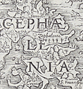 | Details | Munster, Sebastien | 1571 |
| Antique map of the island of Cephalonia, Greece |
|
Munster, Sebastien |
|
| 1571 |
| LOC:0 |
| $0.00 | Munster--Sebastien | Antique-map-of-the-island-of-Cephalonia--Greece | SOLD<br></br>Rare original 16th century wood cut map of Cephalonia ( Kefalonia ), Greece, the largest of the Ionian islands. In this decorative map from 1571 a half dozen towns are identified including Fiskardo ( "Viscardo" ), "Palis", Sami ( "Samos" ), "Cranis", and "S. Francifeus".
<br></br>
The Ionian islands are off the West coast of the Peloponnese peninsula in Southern Greece. The island of Lefkada ( "Levcas" ) is shown to the north.
<br></br>
From "Strabonis rerum geographicarum libri septemdecim" authored by Sebastien Munster and published by Heinrich Petri. Map is inset in a 8"x11"full page of text, both in Greek and Latin. Text on verso. |
| 832 | 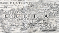 | Details | Munster, Sebastien | 1571 |
| Antique wood cut of the island of Crete, Greece |
|
Munster, Sebastien |
|
| 1571 |
| LOC:2 |
| $150.00 | Munster--Sebastien | Antique-wood-cut-of-the-island-of-Crete--Greece | Antique map of Crete ( "Creta" ), Greece in the southern Aegean Sea. In this decorative map from 1571 numerous towns are identified including Heraklion ( "Heraclea" ) , Chania ( "Candia" ), Rethymno ( "Rhithymna" ), and "Minoa". Crete was home to the Bronze age Minoan civilization. Today remains of the Minoan civilization are found across the island, particularly at the archaeological sites of Knossos, Phaistos, Malia, and Kato Zakros.
Several mountain chains and rivers are shown on this rare wood cut map of Crete. In the bottom right corner Munster has placed a large oared galley, with the Lion of St. Marks painted on its lateen sail, signifying Venice's rule over the island for more than four centuries.
<br></br>
From "Strabonis rerum geographicarum libri septemdecim" authored by Sebastien Munster and published by Heinrich Petri. Map is inset in a 8"x11"full page of text, both in Greek and Latin. Text on verso. |
| 851 | 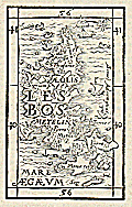 | Details | Munster, Sebastien | 1571 |
| Antique wood cut of the island of Lesbos, Greece |
|
Munster, Sebastien |
|
| 1571 |
| LOC:2 |
| $150.00 | Munster--Sebastien | Antique-wood-cut-of-the-island-of-Lesbos--Greece | Antique wood block printed map of the island of Lesbos ( Lesvos ), Greece in the northeastern Aegean Sea.
<br></br>
From "Strabonis rerum geographicarum libri septemdecim" authored by Sebastien Munster and published by Heinrich Petri. Map is inset in a 8"x11" full page of text, both in Greek and Latin. Text on verso. |
| 4727 | 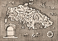 | Details | Porcacchi, Tomasso | 1572 |
| Very old antique map of Rhodes, Greece |
|
Porcacchi, Tomasso |
|
| 1572 |
| LOC:2 |
| $275.00 | Porcacchi--Tomasso | Very-old-antique-map-of-Rhodes--Greece | Authentic copperplate-engraved antique map (1572) of the Greek Dodecanese island of Rhodes (Rhodi) engraved by Girolamo Porro and drawn by Tomasso Porcacchi. Numerous fantastical sea serpents and monstrous fishes fill empty areas in the finely stippled seas. A few of the key features include smaller islands of Carchi, Limona, San Nicolo, and Tranquilla. Detail in the interior of Rhodes includes towns or villages of Villanova, Camira, Aganca, Zalfo, Sorini, Fiando, Rufarcangeli Farado, and more. The port of Rhodes or Rhodos is shown surrounded by fortified walls with several guard towers.
<br></br>
Printed in Tomasso Porcacchi's "Isolario" or island book "L'Isol Piu Famose Del Mondo". That work contains a number of finely engraved maps of islands and the continents at a reduced scale. Porcacchi (1530-1585) was born in Tuscany to a poor family and first settled in Florence. He wrote about history, geography, and archaeology and later published the Isolario from Venice, Italy in three editions beginning in 1572. |
| 916 | 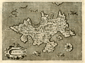 | Details | Porcacchi, Tomasso | 1572 |
| Greek Island of Zakynthos or Zante in the Ionian Sea |
|
Porcacchi, Tomasso |
|
| 1572 |
| LOC:2 |
| $175.00 | Porcacchi--Tomasso | Greek-Island-of-Zakynthos-or-Zante-in-the-Ionian-Sea | Copperplate-engraved antique map (1576), engraved by Girolamo Porro and drawn by Tomasso Porcacchi, of the Greek Ionian island of Zante or Zakynthos, the third largest of the Ionian Islands. A few of the key features Porcacchi notes on this old map of Zakynthos are: Plomati, Ambello, Zero Castelli, la Madonna, Santa Maria de Piscopo, and a large saline or salt marsh in a large bay to the north. Fantastical sea serpents fill empty areas in the finely stippled seas.
<br></br>
On a full page with text on recto and verso. Woodcut capital letter "I" at the beginning of the textual desription of Zante, in Italian, just below the map. Woodcut headpiece and a scrollwork title cartouche with simply "Zante".
<br></br>
Printed in Tomasso Porcacchi's "Isolario" or island book "L'Isol Piu Famose Del Mondo". That work contains a number of finely engraved maps of islands and the continents at a reduced scale. Porcacchi (1530-1585) was born in Tuscany to a poor family and first settled in Florence. He wrote about history, geography, and archaeology and later published the Isolario from Venice, Italy in three editions beginning in 1572. Page 98. |
| 915 | 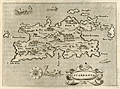 | Details | Porcacchi, Tomasso | 1576 |
| Greek Island of Karpathos or Scarpanto in the Aegean |
|
Porcacchi, Tomasso |
|
| 1576 |
| LOC:2 |
| $250.00 | Porcacchi--Tomasso | Greek-Island-of-Karpathos-or-Scarpanto-in-the-Aegean | Interesting antique map from 1576, by Tomasso Porcacchi, of the Greek Aegean island of Scarpanto or Kárpathos, about 30 miles southwest of Rhodes. Karpathos is part of the Dodecanese island group. A few of the key features Porcacchi notes on this old map are: Porto Grato, Porto Tristano, Capo Bonadrea, Castro Calamo, and Fianti. The walled village of Scarpanto is depicted on the East end of the island with three mountains directly to the west: M. St. Elya, M. Ores, and M. Anchinara.
<br></br>
On a full page with text. Wood-cut capital letter "P" at the beginning of the textual desription of Candia, in Italian, just below the map.
<br></br>
Printed in Tomasso Porcacchi's "Isolario" or island book "L'Isol Piu Famose Del Mondo". That work contains a number of finely engraved maps of islands and the continents at a reduced scale. Porcacchi (1530-1585) was born in Tuscany to a poor family and first settled in Florence. He wrote about history, geography, and archaeology and later published the Isolario from Venice, Italy in three editions beginning in 1572. Page 113. |
| 913 | 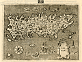 | Details | Porcacchi, Tomasso | 1576 |
| Island of Candia (Crete) in Greece |
|
Porcacchi, Tomasso |
|
| 1576 |
| LOC:2 |
| $275.00 | Porcacchi--Tomasso | Island-of-Candia-(Crete)-in-Greece | Very interesting early antique map of the Greek Mediterranean island of Candia (Crete or Kriti), the largest island in Greece. This late 16th century map, by Tomasso Porcacchi, shows some of the largest towns on the island at that time: Cania (Chania), Retimo (Rethimno), and Candia (Iraklio). Numeous small islands and islets are named offshore including Morena, Farioni, Paxmando, and Standia. In the stippled sea, empty space is filled with fanciful sea creatures, huge sea snails, crabs, and a three-masted galleon.
<br></br>
At the center of the map is a cicular design of a maze south of the town of Candia (Iraklio or Heraklion). That maze is a reference to the labyrinth of King Minos of Crete that was believed to be located at the palace at Knossos. Since classical times that site was believed to be the location where Daedalus built the labyrinth for King Minos to hold the mythical Minotaur.
<br></br>
The entrance to three caves is depicted near the southwest coast in the general vicinity of the well-known Samaria Gorge. At that spot Porcacchi has noted: "Habitation d' homini e bestiami nelle chuerne" or the dwelling of men and cattle in ?chuerne.
<br></br>
Printed in Tomasso Porcacchi's "Isolario" or island book "L'Isol Piu Famose Del Mondo". That work contains a number of finely engraved maps of islands and the continents at a reduced scale. Porcacchi (1530-1585) was born in Tuscany to a poor family and first settled in Florence. He wrote about history, geography, and archaeology and later published the Isolario from Venice, Italy in three editions beginning in 1572. Page 108. |
| 693 |  | Details | Munster, Sebastien | 1580 |
| Antique early map of Greece with Istanbul |
|
Munster, Sebastien |
|
| 1580 |
| LOC:2 |
| $0.00 | Munster--Sebastien | Antique-early-map-of-Greece-with-Istanbul | SOLD
<br><br>
Antique woodcut map of Greece published ca. 1578 by Sebastien Munster in a French edition of his Cosmographie. At extreme upper right Munster denotes the triple-walled city of Constantinople (modern Istanbul, Turkey) astride the Bosphorus Strait. In addition to Constantinople, small iconized dwellings represent the towns of Edirne ( Adrianople ), Modon, Corinth, and Salonica. Other geographical features include: Mount Olympus, Thrace, Albania, Macedonia, and the Greek Islands of Crete, Corfu, Lemnos, Lesbos, Samos, Melos, and Negroponte.
<br></br>
Woodcut is inset into French text. Verso contains French text and a small woodcut of a 16th century nobleman. Page 1052. |
| 947 | 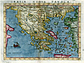 | Details | Ruscelli, Girolamo | 1598 |
| Scarce antique map of the Greek Archipelago |
|
Ruscelli, Girolamo |
|
| 1598 |
| LOC:0 |
| $0.00 | Ruscelli--Girolamo | Scarce-antique-map-of-the-Greek-Archipelago | SOLD
<br></br>
Antique map of <b>Greece</b> published in 1598. The third state of Ruscelli's map of Greece and one of the earliest obtainable maps of modern Greece, derived from Gastaldi's map of 1548. Coverage includes Istanbul ("Costantinopili"), Turkey; Izmir ("Smirne"), Turkey; Crete, Negroponte, Corfu, and the Cycladic Greek Islands; Otranto and Gallipoli, Italy; and part of the Gulf of Venice.
<br></br>
This colorful, scarce map is from the sixth edition of <b>Girolamo Ruscelli's</b> translation of Claudio Ptolemy's Geografia with 27 Ptolemaic maps and 42 other maps based on modern sources.
<br></br>
Girolamo Ruscelli (1504 - 1566) was an Italian cartographer and writer who, under the pseudonym <b>Alexius Pedemontanus</b>, published the popular book "<i>The Secrets of Alexis of Piedmont</i>". That book was an early contribution to the scientific revolution that arose during the Rennaisance. |
| 948 | 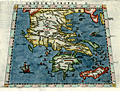 | Details | Ruscelli, Girolamo | 1598 |
| Scarce Ptolemaic map of Greece |
|
Ruscelli, Girolamo |
|
| 1598 |
| LOC:2 |
| $0.00 | Ruscelli--Girolamo | Scarce-Ptolemaic-map-of-Greece | SOLD
<br><br>Colorful engraved antique map of Greece on a trapezoidal projection published in 1598, based on the work of <b>Claudius Ptolemy</b>. Coverage includes mainland Greece, the <b>Peloponnese Peninsula</b>, Crete, Cyclades Archipelago, the Sporades and Ionian Islands, and the Gulf of Corinth.
<br></br>
This scarce map is from the sixth edition of Girolamo Ruscelli's translation of Claudio Ptolemy's <b>Geografia</b> with 27 Ptolemaic maps and 42 other maps based on modern sources. Ptolemy (ca. 100 AD - 170 AD) was a Greco-Egyptian cartographer who lived in Alexandria, Egypt. Ptolemy's Geografia was a a compilation of geographical coordinates of the world's locations and geographic features known to the Roman Empire in the second century AD.
<br></br>
Girolamo Ruscelli (1504 - 1566) was an Italian cartographer and writer who, under the pseudonym <b>Alexius Pedemontanus</b>, published the popular book "<i>The Secrets of Alexis of Piedmont</i>". That book was an early contribution to the scientific revolution that arose during the Rennaisance. |
| 891 | 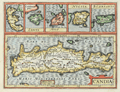 | Details | Jansson, Jan | 1630 |
| Antique map of Crete, Corfu, Zante, Milo, Naxos, Scarpanto |
|
Jansson, Jan |
|
| 1630 |
| LOC:2 |
| $315.00 | Jansson--Jan | Antique-map-of-Crete--Corfu--Zante--Milo--Naxos--Scarpanto | Antique map of several of the <b>Cycladic Greek islands</b> plus Corfu. A reduced-size copperplate engraving of Mercator's map of Crete ( "Candia" ) with inset maps above for the Greek isles of Corfu, Zante, Milos, Naxos ( "Nicsia" ), and Scarpanto.
<br></br<
Published 1630 by Jan Jansson from Amsterdam for Gerard Mercator's "Atlas Minor". Latin text on verso. |
| 821 | 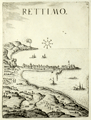 | Details | Boschini, Marco | 1651 |
| Rethymno in Crete, Greece |
|
Boschini, Marco |
|
| 1651 |
| LOC:0 |
| $0.00 | Boschini--Marco | Rethymno-in-Crete--Greece | SOLD<br></br>
Rare profile view of the Cretan village of Rettimo (Rethimno), Crete in Greece . The town is shown as it then existed, a narrow peninsula with the port and its jetties jutting out to the East. The great Fortress of Rethymno is clearly visible high and well protected at the northern end of the peninsula. Galleys and sea serpents fill empty space in the sea.
<br></br>
By Marco Boschini (1613-1678) from Venice in 1651. Published in Boschini's atlas of 59 engraved views and city plans and 2 maps of Crete at a time when the island of Crete, then a Venetian territory, was under siege from Ottoman forces.
<br></br>
Boschini derived his engravings from the manuscript works of others including Angelo degli Oddi, Francesco Basilicata, and especially Georgio Corner. Although he never visited Crete, Boschini's unique contribution is that his atlas was the first published atlas to focus solely on Crete and it provided information about that embattled island to a thirsty public. (Porfyriou, Helene. The Cartography of Crete in the First Half of the 17th Century: a Collective Work of a Generation of Engineers, Web; http://ine-notebooks.org/index.php/te/article/viewFile/109/165) |
| 822 | 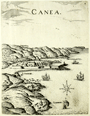 | Details | Boschini, Marco | 1651 |
| Chania in Crete, Greece |
|
Boschini, Marco |
|
| 1651 |
| LOC:0 |
| $0.00 | Boschini--Marco | Chania-in-Crete--Greece | SOLD<br></br>
Rare view of the walled town of Chania on the Greek island of Crete in context with the surrounding geographic features and villages. The small walled town on the North coast of Crete can be seen have the same harbor structure and covered workshops of the Grand Venetian Arsenal as still exist today. Noted nearby features include : Galata ( Galatas ), S. Fanavro,and S. Chiriaci. A simple wind rose is found in the sea along with images of a galley under oars and three square-rigged ships under sail.
<br></br>
By Marco Boschini (1613-1678) from Venice in 1651. Published in Boschini's atlas of 59 engraved views and city plans and 2 maps of Crete at a time when the island of Crete, then a Venetian territory, was under siege from Ottoman forces.
<br></br>
Boschini derived his engravings from the manuscript works of others including Angelo degli Oddi, Francesco Basilicata, and especially Georgio Corner. Although he never visited Crete, Boschini's unique contribution is that his atlas was the first published atlas to focus solely on Crete and it provided information about that embattled island to a thirsty public. (Porfyriou, Helene. The Cartography of Crete in the First Half of the 17th Century: a Collective Work of a Generation of Engineers, Web; http://ine-notebooks.org/index.php/te/article/viewFile/109/165) |
| 823 | 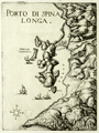 | Details | Boschini, Marco | 1651 |
| Spinalonga Peninsula and Elounda in Crete, Greece |
|
Boschini, Marco |
|
| 1651 |
| LOC:2 |
| $450.00 | Boschini--Marco | Spinalonga-Peninsula-and-Elounda-in-Crete--Greece | Very scarce and attractive copper-plate engraved view of the entire Spinalonga Peninsula and surrounding area on the island of Crete, Greece. Includes the island of Kalydon (shown with a fortress dominating the bay); the island of "Colochita" ( Kolokythas ); and structures in the vicinity of today's villages of Elounda and Plaka. The southern-most of these structures at the bottom of the Bay of Elounda are referred to as "Culata". The view shows a signal fire burning at the headland of Cape Agios Ioannis, overlooking the entire Mirambellos Gulf. Numerous galleys are shown at sea headed to shore, and interestingly none of the galleys are under sail.
<br></br>
By Marco Boschini (1613-1678) from Venice in 1651. Published in Boschini's atlas of 59 engraved views and city plans and 2 maps of Crete at a time when the island of Crete, then a Venetian territory, was under siege from Ottoman forces.
<br></br>
Boschini derived his engravings from the manuscript works of others including Angelo degli Oddi, Francesco Basilicata, and especially Georgio Corner. Although he never visited Crete, Marco Boschini's unique contribution is that his atlas was the first published atlas to focus solely on Crete and it provided information about that embattled island to a thirsty public. (Porfyriou, Helen. The Cartography of Crete in the First Half of the 17th Century: a Collective Work of a Generation of Engineers, Web: http://ine-notebooks.org/index.php/te/article/viewFile/109/165) |
| 18 | 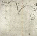 | Details | Levanto, Francesco M. | 1664 |
| Carta Maritima della Meridionale Costa di MOREA |
|
Levanto, Francesco M. |
|
| 1664 |
| LOC:8 |
| $900.00 | Levanto--Francesco-M- | Carta-Maritima-della-Meridionale-Costa--di-MOREA | Rare Genoan antique nautical chart of the Greek coast including the named islands of Sapienza, Schiza, I. Cervij ( Elafonisos ), Serigo (Kythera), and Serigotto (Antikythera), Greece. Antikythera is best known for being near the site at which the so-called <b>Antikythera mechanism</b> was recovered by sponge divers in 1900. That mechanism is an early clockwork device with meshed bronze gears that allowed the user to calculate the position of astronomical objects, eclipses, and lunar phase by rotating a hand crank. The significance of the device is that it is believed to date from antiquity- 67 BC and is by far the oldest analog computer ever discovered.
<BR> </BR>
Coverage includes a long stretch of the southern coast of the <b>Peloponnese peninsula</b>, known in earlier times as the Morea. Primary geographic features include Cape Matapan and Cape Maleo ( Cap San Angelo) with the following settlements identified by name: Modon ( Methoni ), Coron ( Koroni ), Vitulo ( Porto Vitilo ). Porto Rapini is a bit more difficult to identify but based on 19th century works only present-day Marathias fits the location. Almost 2 centuries after this chart was published, Norie described Porto Rapina: <div class="indenttextblock"> "you will see a long even point of land and behind it two round hills" . . . "there are two small islands before the northern entrance to the port" and noted that the Island of Cervi was "7 miles southward". </div> That description fits only Marathias. (Norie, John William. New Mediterranean Pilot. 1817, p 140.)
<BR> </BR>
This old sea chart was produced by Genoan cartographer <b>Francesco Maria Levanto</b> in 1664. Levanto's "La Prima Parte dello Specchio del Mare" (Sea Mirror) was probably based on earlier Dutch charts, possibly by Jacobsz.
<BR> </BR>
This chart was reissued about 40 year later by Coronelli. Charts from the Specchio del Mare are quite scarce. Plate 17. Oriented North at top. Chain laid paper. |
| 381 | 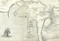 | Details | Anonymous | 1675 |
| Plan de la Ville de Rode |
|
Anonymous |
|
| 1675 |
| LOC:2 |
| $950.00 | Anonymous | Plan-de-la-Ville-de-Rode | Scarce engraving of the port of Rode (Rhodes), Greece decorated with a bat-form title cartouche, a square-rigged warship, and three galleys. References on the plan to the 'Grand Master' and 'Sultan Suleiman' suggest that the map was intended to illustrate the Siege of Rhodes in 1522 when the Knights of Rhodes were defeated and driven out by the Ottomans. That order later became known as the 'Knights of Malta' after they established residence on the island of Malta in 1530.
<BR> </BR>
We cannot locate an identical copy of this anonymous work anywhere on-line but the topographic details are nearly identical to those in a map by Dapper from 1687. This example probably dates from a period between 1650 - 1675 because this map contains more explanatory detail (in French) than Dapper's map and the strapwork cartouche points to an earlier style.<BR> </BR>
Numerous geographic descriptions include: the palace of the Grand Master; port des galeres; Tour de St. Jean; port des vaisseaux; the old walled village of Rhodes, and two long breakwaters, each protected by a tower at the end. Strapwork mileage scale. |
| 935 |  | Details | Peeters, Jan | 1680 |
| Decorative antique map of Crete, Greece |
|
Peeters, Jan |
|
| 1680 |
| LOC:2 |
| $190.00 | Peeters--Jan | Decorative-antique-map-of-Crete--Greece | Antique frontispiece with the island of Crete, Greece (Candia) published from Antwerp by Peeters in a volume with several prints of views of key cities on Crete. Map of the key Greek island of Crete with the labyrinth ("laberinta") of King Minos identified in the middle of the island. Names several important cities including "Canea" (Chania), "Candia" (Iraklio), "Fenice", "Penico" and "Matoli".
<br></br>
Set among a scene depicting the aftermath of a battle with two figures holding a sheet with the coat of arms of Pope Innocent XI ("Innocentius XI Pontifex Maximus"). One of the figures appears to be a representation of a Turk with a scimitar standing on the holy Christian cross, representing the conflict between the Ottoman Empire and Venice for control of Crete in the 17th century.
<br></br>
Attribution reads: "I. Peeters excudit- Antverpi." Conrad Lauwers sculp. |
| 914 | 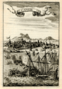 | Details | Mallet, Allain Manesson | 1683 |
| Candie |
|
Mallet, Allain Manesson |
|
| 1683 |
| LOC:2 |
| $85.00 | Mallet--Allain-Manesson | Candie | Small, attractive antique view of the harbor of Candia (Heraklion or Iraklio) on Crete, Greece with mosques and other buildings surmounted by the cresent moon of the Ottoman Caliphate. Galleys and other warships battle offshore in the Mediterranean Sea and the smoke of cannon fire indicate a westerly breeze. By Allain Mallet, Paris, 1683.
<br></br>
The Ottomans captured most of Crete during the early years of the Cretan War (1645-1669) but the Venetians retained control of the capital, Candia, until the very end in 1669. This engraved view probably captures a moment in the final battle for control of Heraklion. Page 203.
<br></br>
Published by Mallet in "Description de l'Univers" . Allain Mallet (1630-1706) was a French engineer, soldier, and cartographer. He served in the court of King Louis XIV as a techer of mathematics. In addition to "Description de l'Univers" Mallet also published "Les Travaux de Mars ou l'Art de la Guerre". |
| 898 | 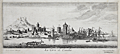 | Details | Peeters, Jan | 1685 |
| Scarce panoramic view of Iraklio on the Greek island of Crete |
|
Peeters, Jan |
|
| 1685 |
| LOC:2 |
| $180.00 | Peeters--Jan | Scarce-panoramic-view-of-Iraklio-on-the-Greek-island-of-Crete | This fine antique etching is a panoramic profile view of the city of <b>Iraklio ("Candia")</b> on the island of Crete, Greece. With a backdrop of the fortified town of Iraklio and a harbor full of square-rigged ship's masts the view shows two galleys (presumed Venetian) departing the harbor and heading out to sea.
<br></br>
At the time this etching was published Venice was at war with the Ottoman Empire. Venice had been in control of Crete until 1669 when the Ottomans overran the island but failed to capture Iraklio. Venice managed to hang on to Iraklio until 1715.
<br></br>
Published by Jacob Peeters in Antwerp, ca 1685. Based on a drawing by the brother of Jacob Peeters- Jan (Johannes) Peeters. The etching originates from Peeter's rare edition of: 'Korte beschryvinghe, ende aenwysinghe der plaetsen in desen boeck, naar hunnen tegenwoordighen standt, pertinentelyck uyt-ghebeeldt, in Oostenryck", a collection of prints relating to the <b>Great Turkish war (1667-1683)</b>. |
| 1416 | 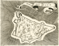 | Details | Coronelli, Vincenzo | 1686 |
| 17th century map of the Bohali fortress at Zakynthos, Greece |
|
Coronelli, Vincenzo |
|
| 1686 |
| LOC:2 |
| $160.00 | Coronelli--Vincenzo | 17th-century-map-of-the-Bohali-fortress-at-Zakynthos--Greece | Attractive 17th-century plan of the Venetian castle fortress on the island of Zakynthos or "Zante", Greece. Set atop a hill in the Bohali region of Zakynthos, the Bohali Castle is estimated to have been built in 1480 on the site of the ancient Acropolis. During the period of Venetian rule, the Castle was the capital of Zakynthos island, destroyed and repaired several times. In 1646 the walls were completed with help from the Venetians and their presence is apparent on the main outer gate where the wall bears the emblem of the famous Venetian 'Lion of St.Mark'.
<br></br>
Recent archaeological excavations at the Bohali Castle have found monuments from the Byzantine period, including a church dated to the 12th century.
<br></br>
This scarce wood-cut map was published by father Vincenzo Coronelli from Venice, Italy ca 1686 in "Memorie istoriografiche delli regni della Morea e Negroponte…".
<br></br>
Vincenzo Maria Coronelli (1650-1718) was an Italian Franciscan friar, cartographer, cosmographer and encyclopedist. Coronelli, a trained wood engraver, studied astronomy, Euclidean geometry and ancient philosophy and was named cosmographer for the Republic of Venice. He became most famous for his very large globes built in Paris from 1681-1683 at the order of King Louis XIV. His terrestrial and celestial globes measured 3.9 meters in diameter and were not equaled for more than 200 years. |
| 1255 | 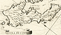 | Details | Coronelli, Vincenzo | 1686 |
| 17th century map of the Island of Corfu, Greece |
|
Coronelli, Vincenzo |
|
| 1686 |
| LOC:2 |
| $210.00 | Coronelli--Vincenzo | 17th-century-map-of-the-Island-of-Corfu--Greece | Fine antique map of the Greek island of Corfu which lies in the Ionian sea off Greece's northwest coast.
Key features on this attactive map of Corfu include the Canale di Corfu, the Fortezza (Fortress) di Corfu, and the villages of Agios Stefanos (s. Stefano), Scarpero (Skripero), Cauadales, Corissia (Lake Korission), and Neocon (Neochori).
<br></br>
This scarce wood-cut map was published by father Vincenzo Coronelli from Venice, Italy ca 1686 in "Memorie istoriografiche delli regni della Morea e Negroponte…".
<br></br>
Vincenzo Maria Coronelli (1650-1718) was an Italian Franciscan friar, cartographer, cosmographer and encyclopedist. Coronelli, a trained wood engraver, studied astronomy, Euclidean geometry and ancient philosophy and was named cosmographer for the Republic of Venice. He became most famous for his very large globes built in Paris from 1681-1683 at the order of King Louis XIV. His terrestrial and celestial globes measured 3.9 meters in diameter and were not equaled for more than 200 years. |
| 1256 | 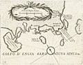 | Details | Coronelli, Vincenzo | 1686 |
| 17th century map of Saronic Islands and Athens, Greece |
|
Coronelli, Vincenzo |
|
| 1686 |
| LOC:2 |
| $230.00 | Coronelli--Vincenzo | 17th-century-map-of-Saronic-Islands-and-Athens--Greece | Attractive map from 1686 of the Attic region and islands of the Saronic Gulf in the neighborhood of Athens, Greece. Major islands shown include Kea, Salamina, Egina, Makronisos, and Patroklos (Patrocleia). Other features Coronelli deemed important were Porto Rafti and the Temple of Minerva. Athens is shown as "Atene" just to the north of a very shrunken Athenian Peninsula. In the vicinity of today's port of Pireas, Greece only a single tower "torre" is shown along with a depiction of dots and crosses in the water signifying rocks or other low-lying navigational hazard.
<br></br>
This scarce wood-cut map was published by father Vincenzo Coronelli from Venice, Italy ca 1686 in "Memorie istoriografiche delli regni della Morea e Negroponte…".
<br></br>
Vincenzo Maria Coronelli (1650-1718) was an Italian Franciscan friar, cartographer, cosmographer and encyclopedist. Coronelli, a trained wood engraver, studied astronomy, Euclidean geometry and ancient philosophy and was named cosmographer for the Republic of Venice. He became most famous for his very large globes built in Paris from 1681-1683 at the order of King Louis XIV. His terrestrial and celestial globes measured 3.9 meters in diameter and were not equaled for more than 200 years. |
| 687 | 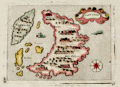 | Details | Porcacchi, Tomasso | 1686 |
| Antique map of Santorini, Greece |
|
Porcacchi, Tomasso |
|
| 1686 |
| LOC:2 |
| $300.00 | Porcacchi--Tomasso | Antique-map-of-Santorini--Greece | Old antique copperplate-engraved map of the Greek island of Santorini, Greece in the Aegean Sea. Noted points of interest include the islands of Aspronisi and Therasia, nearby Santorini, along with the Santorinan habitations of S. Salvador, Akrotiri ("Acortiri") , Scaro, and Nebrio. The colorful map was printed in 1686 in one of the last editions of Tomasso Porcacchi's "Isolario" or island book " L'Isol Piu Famose Del Mondo" which was first published in Venice ca. 1572. This 1686 edition is differentiated from earlier versions of Porcacchi's atlas in that 1) it is the only edition where the maps are not set within printed text, and 2) the chart was re-engraved for this edition and the compass rose is less elaborate.
<br></br>On the compass rose Porcacchi identifies eight points that correspond to the classical eight-point naming convention for Mediterranean winds that dates back at least 2000 years. The octagonal "Tower of the Winds" of the Roman Agora in Athens, Greece contains friezes on each wall depicting the principal wind deities and was once capped with a weathervane. Porcacchi's compass rose symbols "T", "G", "+" , "S", "O", "L", "P", "M", correspond to the Italian names for the principal Mediterranean winds: Tramontana ( North ), Greco, Levante ( with a cross denoting East ), Sirocco, Ostro ( South ), Libeccio. Ponente ( West ), and Maestro. ( Taylor, E.G.R., "The Haven Finding Art: A History of Navigation from Odysseus to Captain Cook". New York. 1957 (pp. 6-8)
<br></br>
Simple design as is common in the Isolario maps with depictions of two mythical sea monsters and a scrollwork title cartouche labeled simply: "Santorini". Seas are stippled
<br></br>
Ample margins and hand-coloring make this antique map of Santorini a fine candidate for framing. |
| 903 | 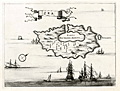 | Details | Dapper, Olfert (Olivier) | 1688 |
| Cycladic Greek Island of Kea |
|
Dapper, Olfert (Olivier) |
|
| 1688 |
| LOC:2 |
| $130.00 | Dapper--Olfert-(Olivier) | Cycladic-Greek-Island-of-Kea | Antique copper-plate engraved chart / plan of Kea ("Zea") or Tzia , an island in the Cyclades Archipelago of Greece, less than 40 miles from Athens. The attractive old map greatly overstates the size of the main port Korissia or "Porto per Grande Armata" relative to the rest of the island and understates the remaining area on the island to the west of the main settlement of Zea near the capital of Ioulis. Other areas noted by Dapper are the tiny island of "Scoglieto" and the "Fonte della Pazzia".
<br></br>
From Olfert Dapper's 1688 edition of his Descripion of the Mediterranean Islands or "Naukeurige beschryving der Eilanden, in de Archipel der Middelantsche Zee, en omtrent dezelve, gelegen: waer onder de voornaemste Cyprus, Rhodus, Kandien, Samos, Scio, Negroponte ...". Dapper was a Dutch writer and self-described physician best known for his books on Africa, China, Persia and Arabia.
<br></br>
Verso is blank. |
| 969 | 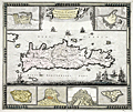 | Details | de Wit, Frederick | 1690 |
| Frederick de Wit's map of Crete with Heraklion, Chania and more |
|
de Wit, Frederick |
|
| 1690 |
| LOC:0 |
| $0.00 | de-Wit--Frederick | Frederick-de-Wit-s-map-of-Crete-with-Heraklion--Chania-and-more | SOLD
<br></br>
Highly decorative antique hand-colored map by de Wit of the island of Crete (Creta), Greece with six attractive insets plans showing the fortifications of Canea/ Chania, Candia / Heralkion, Spinalonga / Kalydon, Retimo/ Rethimnon, Thine / Tinos and Suda. The insets are after drawings of Sébastien Pontault de Beaulieu (1612-1674). Pontault, a French engineer, is considered to have been the inventor of the art of military topography.
</br></br>
For the insets of both Chania and Iraklio Wit has included a legend of key place names keyed alphabetically to locations on the plans. In the interior of this lovely map of Crete Wit includes mountains, rivers, villages, lakes, forts, and he records an extensive road network ranging widely across the island. Decorative elements include square-rigged ships, galleys, and putti carrying a sheet containing the title block.
</br></br>
At upper left are portions of the nearby islands of Kythera ("Cerigo") and Antikythera ("Cecerigo"). Fortifications of Spinalonga Island or Kalydon (just north of the Spinalonga Peninsula, near Elounda and Agio Nikolaos) are shown at bottom right. During the Venetian occupation of Crete Spinalonga Island was home to a fortress controlled by the Ventians until 1715.
</br></br>
From Amsterdam ca. 1690. Attribution reads: "by Frederick de Wit inde Kalverstraat inde Witte Paskaert".
Plate 23. Manuscript numeric "60" in top right corner. |
| 1278 |  | Details | Dapper, Olfert (Olivier) | 1703 |
| De l'Ile de Scyros (Skyros) |
|
Dapper, Olfert (Olivier) |
|
| 1703 |
| LOC:0 |
| $115.00 | Dapper--Olfert-(Olivier) | De-l-Ile-de-Scyros-(Skyros) | Antique copper-plate engraved map of the <b>Greek Island of Skryos</b> (also Skiros or Scyros) by Olfert Dapper. Skyros is the southernmost island in the <b>Sporades Archipelago</b>. Dapper notes by name two smaller nearby islands, Schirodola (Skiropoula), and Skantzoura (Scanda) and off the east coast Dapper identifies 4 anchorages maked with "A" and notes: "Tutti Buoni Porti".
<br></br>
Decoratively presented with a ribbon title block and depictions of a square-rigged man-of-war and two galleys with lateen sails. North is oriented at the top left corner.
<br></br>
From "Description exacte des isles de l'archipel, et de quelques autres adjacentes…" by Olfert Dapper. This leaf with French text from 1703 was originally published in Dutch in 1688. |
| 1288 | 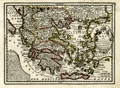 | Details | Chiquet, Jacques | 1719 |
| Old antique map of The Greek Archipelago |
|
Chiquet, Jacques |
|
| 1719 |
| LOC:2 |
| $210.00 | Chiquet--Jacques | Old-antique-map-of-The-Greek-Archipelago | Decorative map of Greece and Turkey displaying the wide extent of the Aegean Archipelago. Fine engraving and a title cartouche flanked by two winged female figures, topped by a fan shaped shell. Dated within at 1719. This attractive antique map, now nearly 300 years old, is characterized by its strong impression, evident platemark, and restrained hand coloring.
<br></br>
Named features include: Negroponte, Athens, the Peloponnese, Zante, Corfu, Macedonia, Constantinople,
Naxos, Santorini, Crete, and Rhodes.
<br></br>
From "Le Nouveau et Curieux Atlas Geographique et Historique..." by Jacques Chiquet. |
| 869 | 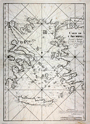 | Details | Depot de la Marine | 1745 |
| Antique Chart of the Aegean Sea, Turkey and Greek Archipelago |
|
Depot de la Marine |
|
| 1745 |
| LOC:58 |
| $1,400.00 | Depot-de-la-Marine | Antique-Chart-of-the-Aegean-Sea--Turkey-and-Greek-Archipelago | Scarce antique chart of the Greek Archipelago including parts of mainland Greece and Turkey. This large copperplate-engraved nautical chart of the Aegean Sea is based on surveys by French naval pilot Arnaud Grognard (1681-1751) and published by the Depot de la Marine.
<br></br>
Dedicated to Jean-Frédéric Phélypeaux comet de Maurepas (1701-1781). Interesting signed approval by Jacques Bellin, of the French Depot de la Marine" which translates roughly to: 'I examined the chart of the archipelago presented by Sieur Grognard, a pilote of the department from Toulon, under orders of the Count de Maurepas, and I find it is acceptable for navigation…". Bellin published many charts under his own name and it is unusual to find this type of signed attribution of a chart published by the Depot. |
| 628 | 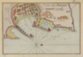 | Details | Roux, Joseph | 1764 |
| Antique chart of Rhodes, Greece |
|
Roux, Joseph |
|
| 1764 |
| LOC:2 |
| $185.00 | Roux--Joseph | Antique-chart-of-Rhodes--Greece | Antique nautical chart of the town and harbor of Rhodes on the island of Rhodes, Greece in the Aegean sea, close to the coast of Turkey.
<BR> </BR>
Original copperplate-engraved chart coverage by Joseph Roux includes the walled village of Rhodes, Casa Cornuta, and Rhodes harbor. The harbor and lighthouse, are shown as flanked by two jetties, each supporting a half-dozen windmills, and terminating offshore with a small fort or bastion. Numerous soundings and anchorages would have assisted 18th century mariners in navigating that area. <BR> </BR>
There were at least four small atlases of port and coastal charts that originated from Marseille hydrographers in the 18th century. Beginning in approximately 1727 these atlases included works by cartographers
<a rel="nofollow" href= "/MichelotBremondBackground.aspx"> Michelot and Bremond</a>,
<a rel="nofollow" href= "/Creator/Ayrouard--Jacques"> Jacques Ayrouard</a>,
<a rel="nofollow" href= "/Creator/Roux--Joseph"> Joseph Roux</a>
, and Jean Allezard. This small original chart is from the atlas of Mediterranean ports produced by Joseph Roux - "Recueil des Principaux Plans des Ports et Rades de la Mer Méditerranée". Plate 127. |
| 1100 | 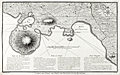 | Details | Le Roy, David | 1770 |
| Antique Chart of Piraeus and Phalere, Greece |
|
Le Roy, David |
|
| 1770 |
| LOC:8 |
| $275.00 | Le-Roy--David | Antique-Chart-of-Piraeus-and-Phalere--Greece | Attractive copper-engraved map of the environs of Piraeus, Greece by David le Roy (1724-1803). Coverage includes Munichia (today Mikrolimano) and Faliro. At the port of Pireaus le Roy identifies an anchorage, ruins of a market, several tombs, the "Maison du Consul", and a few depth soundings. Other key points on the map are the Church of Saint Nicolas and Cap Colias.
<br></br>
Le Roy was French architect and archaeologist, who published a well-researched description of the Acropolis of Athens and other Greek archaeological sites in his 1758 work: " Les Ruines des plus beaux monuments de la Grèce" (<i>Ruins of the Most Beautiful Monuments of Greece</i>). Second edition. |
| 1094 | 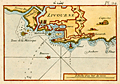 | Details | Roux, Joseph | 1780 |
| Roux antique port plan of Livorno, Italy |
|
Roux, Joseph |
|
| 1780 |
| LOC:4 |
| $165.00 | Roux--Joseph | Roux-antique-port-plan-of-Livorno--Italy | Attractive, antique nautical chart / port plan of the town and harbor of Livorno ("Livourne"), Italy on the Ligurian Sea, southwest of Pisa. Variant edition Plate 24 published from Livorno by Meucci in the "Recueil Des Principaux Plans des Ports et Rades de la Mer Méditerranée, Estraits de ma carte en Douze Feüilles Dediée à Mons. Le Duc de Choiseul Ministre de la guerre et de la Marine …" .
<BR> </BR>
Original copperplate-engraved nautical port plan with depth soundings by Joseph Roux includes the town of Livorno surrounded by double Vauban-style defensive walls; the darce, or interior shipping basin; the Capucine; a lighthouse or signal tower ("fanal"); the "Tours de la Marsoque"; and "Maison de Sante".
<BR> </BR>
Joseph Roux Sr. (1725-1793) was a French cartographer and hydrographer who lived in Marseille. The Roux family, with Roux's son Jospeh Jr. and grandson Antoine Roux, was involved in marine cartography and marine painting from Marseille into the mid-19th century. |
| 1093 | 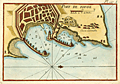 | Details | Roux, Joseph | 1780 |
| Roux antique plan of Rhodes, Greece |
|
Roux, Joseph |
|
| 1780 |
| LOC:2 |
| $225.00 | Roux--Joseph | Roux-antique-plan-of-Rhodes--Greece | Attractive, antique nautical chart / port plan of the town and harbor of Rhodes on the island of <b>Rhodes, Greece</b> in the Aegean sea, close to the coast of Turkey. Variant edition Plate 127A published in "Recueil Des Principaux Plans des Ports et Rades de la Mer Méditerranée, Estraits de ma carte en Douze Feüilles Dediée à Mons. Le Duc de Choiseul Ministre de la guerre et de la Marine …" from Livorno by Meucci.
<BR> </BR>
Original copperplate-engraved chart by Joseph Roux includes the walled village of Rhodes, Casa Cornuta, and Rhodes harbor. The harbor and lighthouse, are shown as flanked by two jetties, each supporting a half-dozen windmills, and terminating offshore with a small fort or bastion. Numerous soundings and anchorages would have assisted 18th century mariners in navigating that area.
<BR> </BR>
Joseph Roux Sr. (1725-1793) was a French cartographer and hydrographer who lived in Marseille. The Roux family, with Roux's son Jospeh Jr. and grandson Antoine Roux, was involved in marine cartography and marine painting from Marseille into the mid-19th century. |
| 536 |  | Details | Choiseul-Gouffier, Marie Gabriel Florent Auguste | 1782 |
| Vue de la Cote de Santorin |
|
Choiseul-Gouffier, Marie Gabriel Florent Auguste |
|
| 1782 |
| LOC:9 |
| $180.00 | Choiseul-Gouffier--Marie-Gabriel-Florent-Auguste | Vue-de-la-Cote-de-Santorin | View of Santorini, Greece, an island in the Aegean Sea. Detailed and picturesque coastal view of villages and windmills perched above a rocky shore on the island of Santorini, Greece in the vicinity of the towns of Oia and Pyrgos. Engraved copperplate etching from the late 18th century. Engraved by J.B. Tilliard from the design by Choiseul-Gouffier.<br><br/>
From le Comte de Choiseul-Gouffier's "Voyage Pittoresque dans l'Empire Ottoman, en Grèce, dans la Troade, les îles de l'Archipel et sur les côtes de l'Asie-Mineure ". Printed before the French revolution with the royal license, "A.P.D.R." or "Avec Privilege Du Roi". Plate 16.<br><br/> |
| 537 |  | Details | Choiseul-Gouffier, Marie Gabriel Florent Auguste | 1782 |
| Plan du Golfe et des Isles de Santorin |
|
Choiseul-Gouffier, Marie Gabriel Florent Auguste |
|
| 1782 |
| LOC:9 |
| $325.00 | Choiseul-Gouffier--Marie-Gabriel-Florent-Auguste | Plan-du-Golfe-et-des-Isles-de-Santorin | Detailed antique map of the north-west coast of the Aegean island of Santorini Greece. Beautifully hachured relief shows offshore islands, villages, windmills, and fields above a rocky shore from the town of Oia (Apanomeria / San Nicolo) to about one French lieue south of the village of Pyrgos. Noted features include the Chateau de Scaro, Maison des Jesuites, and a small anchorage.<br><br/>
Finely engraved copperplate etching from the late 18th century. Engraved by J. Perrier from the survey laid down by F. Kauffer in 1776. <br><br/>
From le Comte de Choiseul-Gouffier's "Voyage Pittoresque dans l'Empire Ottoman, en Grèce, dans la Troade, les îles de l'Archipel et sur les côtes de l'Asie-Mineure ". Printed before the French revolution with the royal license, "A.P.D.R." or "Avec Privilege Du Roi". Plate 13. |
| 1389 | 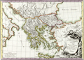 | Details | Pretot, Philippe | 1787 |
| Fine decorative antique map of Greece |
|
Pretot, Philippe |
|
| 1787 |
| LOC:0 |
| $0.00 | Pretot--Philippe | Fine-decorative-antique-map-of-Greece | SOLD<br></br>
Fine antique copper-plate engraved map centered on Greece with elements of the boot of Italy and Asia Minor. This attactive hand-colored engraving by Philippe Pretot includes Athens, Crete, Thera (Santorini), Rhodes, Kos, Naxos, and much more. Fine armorial and landscape-themed cartouche at bottom right. Number 83.
<br></br>
This antique map of Greece is from "Recueil de Cartes pour l'Etude de la Histoire de France." Published by Nyon from Paris in 1787. |
| 2561 | 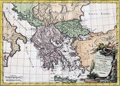 | Details | Pretot, Philippe | 1787 |
| Fine antique map of Greece and Asia Minor |
|
Pretot, Philippe |
|
| 1787 |
| LOC:0 |
| $0.00 | Pretot--Philippe | Fine-antique-map-of-Greece-and-Asia-Minor | SOLD
<br></br>
Fine antique copperplate-engraved map of mainland Greece and the Grecian archipelago. Noted locations include the Agean Sea, the Adriatic Sea (Mare Hadriaticum), the Black Sea (Pontus Euxinus) and Ionian Sea (Mare Ionium). Coverage includes many of the famed islands of Greece with Crete, Rhodes, Santorini (Thera), Mykonos (Mycone), and Samos to name a few.
<br></br>
With a very decorative title cartouche- ancient armor and implements of war resting on a landscape that includes plants and a waterfall. Lettered by Herault. Engraved by Moithey. Number 83. This antique map of Greece is from "Recueil de Cartes pour l'Etude de la Histoire de France." Published by Nyon from Paris in 1787. |
| 533 | 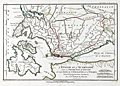 | Details | Bocage, J.D. Barbie du | 1799 |
| Greek Ionian islands of Lefkada, Ithaca and Cephalonia |
|
Bocage, J.D. Barbie du |
|
| 1799 |
| LOC:50 |
| $110.00 | Bocage--J-D--Barbie-du | Greek-Ionian-islands-of-Lefkada--Ithaca-and-Cephalonia | Map covers the Ionian Sea with the islands of Leucade (Lefkada), Ithaca and Cephalonia (Kefalonia) in Western Greece; the Gulf of Patras; and the Gulf of Corinth.
<br></br>
North of the three islands is depicted an area where two of the most well known sea battles of antiquity were conducted. Just off Preveza, Ottoman and Christian galley fleets engaged in one of the last major battles with large numbers of oared fighting vessels. Further inland, in the Ambracian Gulf, forces of Octavian clashed with those of Antony and Cleopatra at the Battle of Actium in 32 BC.
<br></br>
From Bocage's "Recueil de Cartes Geographiques Plans, Vues, et Medailles de l'Ancienne Grece, Relatifs au Voyage du Jeune Anacharsis." Dated to 1799 (Prairial An VI in the French revolutionary calendar). Number 26. |
| 1217 |  | Details | Benard, Robert | 1801 |
| Fine antique map of Santorini, Greece |
|
Benard, Robert |
|
| 1801 |
| LOC:0 |
| $170.00 | Benard--Robert | Fine-antique-map-of-Santorini--Greece | Very attractive map of the volcanic Greek island of <b>Santorini</b> ( Thera ) in the Aegean Sea. A very strong impression and meticulous attention to topographical detail make this an attractive candidate for framing.
<br></br>
Santorini lies within the Cyclades group of islands located in the southern part of the Aegean. The archipelago contains some 2,200 islands, islets and rocks but only 33 islands are inhabited.
<br?</br>
Includes the nearby islands of Thirasia, Palea Kameni and Nea Kameni. Numerous towns and villages within the island of Santorini are identified including:
<div class="indenttextblock">
<ul style="list-style-type: circle;">
<li>Apanomeria ( Oia )</li>
<li>Scauro</li>
<li>Phira ( Fira ) </li>
<li>Acrotiri or Akrotiri</li>
</ul>
</div>
From Guillaume Olivier: "Atlas Pour Servir au Voyage dans L 'Empire Othoman." Plate 7. |
| 3691 | 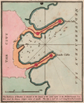 | Details | Luffman, John | 1801 |
| Antique plan of the harbor at Rhodes, Greece for Luffman's Select Plans |
|
Luffman, John |
|
| 1801 |
| LOC:77 |
| $230.00 | Luffman--John | Antique-plan-of-the-harbor-at-Rhodes--Greece-for-Luffman-s-Select-Plans | Fine copper-plate engraved plan of the harbor at Rhodes, Greece, the largest of Greece's Dodecanese islands. Shows the two jetties at the harbor entrance each protected by two fortified positions. Along with the city walls, depth soundings and anchorages are clearly marked. Luffman notes: <div class="indenttextblock">
"The harbour of Rhodes is situated in the island of the same name in the Mediterranean Sea. Here stood the famous colossal statue of Apollo. The city is Lat 36.24 N Long 28.12 E of London."
</div>
</BR>
<br></br>
From "Luffman's Select Plans of the Principal Cities, Harbors, Forts etc. in the World". Engraved and published by John Luffman, No. 28 Little Bell Alley, Coleman Street. London. March 1, 1801. Volume II, Number 1.
<br></br>
Luffman also provided similar engravings to this at about the same time for J.T. Serres' "The Little Sea Torch: or, True Guide for Coasting Pilots." Serres translated the Little Sea Torch from an earlier illustrated coasting pilot guide, based on Bougard's "Le petit flambeau de la mer", first published in 1684.
<br></br>
John Luffman (1751-1821) began his career as an engraver, producing a very large and fine map of Antigua, where he had resided in 1787 and 1789. That map was published by Luffman to accompany his 'A Brief Account of the Island of Antigua', 1788." Luffman shared the same sad fate as many publishers and was declared bankrupt on 9th March, 1793. Moving forward Luffman was more cautious and produced small format atlases and handy-sized maps of the theatres of war, principal towns and cities and battle-plans relating to the Wars of the French directorate and the subsequent Napoleonic War. |
| 1216 | 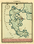 | Details | Luffman, John | 1801 |
| Plan of Corfu engraved for Luffman's Select Plans |
|
Luffman, John |
|
| 1801 |
| LOC:2 |
| $160.00 | Luffman--John | Plan-of-Corfu-engraved-for-Luffman-s-Select-Plans | Copper-plate engraved plan or map of the island of Corfu, Greece by John Luffman. Corfu is a Greek island in the Ionian Sea. The northeastern edge of Corfu lies off the coast of Sarandë, Albania, separated by straits varying in width from 2 to 14 miles.
<br></br>
The town of Corfu is depicted as surrounded by a Vauban-style fortified wall; it's harbor protected by a long 'mole' or breakwater. Coverage includes Castle St. Angelo, Porto Sideri, Porto Timoni, Porto Euripo, Porto Spilea, Formiche, Gudia Island, Condilonisi, and the Valley of St. Stefano.
<br></br>
Description at the bottom reads in part:
<div class="indenttextblock">
"<b>Corfu</b>, anciently Depane, Scheria, Phoeacia, and Corcyra is situated in the mouth of the Gulf of Venice, in the Mediterranean Sea. It was taken from the Venetians by Buonaparte in 1798 and by the Turks and Russians in 1799."
</div>
<br />
From "Luffman's Select Plans of the Principal Cities, Harbors, Forts etc. in the World". Engraved and published by John Luffman, No. 28 Little Bell Alley, Coleman Street, October 1, 1801. Number 15.
<br></br> |
| 1032 |  | Details | Allezard, Jean Joseph | 1811 |
| Chart of Corfu by Allezard |
|
Allezard, Jean Joseph |
|
| 1811 |
| LOC:2 |
| $165.00 | Allezard--Jean-Joseph | Chart-of-Corfu-by-Allezard | Antique chart / plan of the Ionian island of Corfu, Greece, the second largest of the Ionian islands. Includes a portion of the west coast of mainland Greece.
<br></br>
Very interesting note by Allezard at the far northwest of the mainland: "Cent quarante les 3 ecolles". Turns out that the area is Sarande, Albania and that the note is a reference to a Byzantine monastery "the Forty Saints" , honoring the "Forty Martyrs of Sebaste" leading to the Italian name "Santi Quaranta" which Allezard spelled phonetically "Cent Quarante".
<br></br>
One of 163 plates of ports on the Mediterranean, Adriatic and Black seas from Allezard's atlas "Recueil de 163 des principaux plans des ports et rades de la Mediterranée, dont 40 ont été derniérement publiés par Jean Joseph Allezard ancien capitaine de marine et plusieurs des autres corrigés" . This atlas was a re-issue of Joseph Roux's atlas published from Marseille in several editions beginning in 1764. Published by Joseph Gamba from Livorno, Italy. Plate 49. |
| 1408 |  | Details | Lapie, Pierre | 1816 |
| Antique map of Greece and the Balkans |
|
Lapie, Pierre |
|
| 1816 |
| LOC:2 |
| $95.00 | Lapie--Pierre | Antique-map-of-Greece-and-the-Balkans | Antique map of Greece and the Balkans, including the regions of Romania, Bulgaria, Bosnia, Serbia and part of the Black Sea with the western part of Turkey including Constantinople. Much detail about the Greek archipelago. Coverage on this interesting engraved map extends as far south as the island of Crete ("Candie") and encompasses portions of the Ionian Sea, the Mediterranean Sea, the Black Sea, and the Adriatic Sea. Page 27.
<br></br>
Pierre M. Lapie (1779-1850) was a French cartographer and engraver. Lapie, a Colonel in the French army, worked in the corps of topographical engineers. |
| 1030 |  | Details | Allezard, Jean Joseph | 1817 |
| Antique chart of Mykonos, Greece |
|
Allezard, Jean Joseph |
|
| 1817 |
| LOC:2 |
| $145.00 | Allezard--Jean-Joseph | Antique-chart-of-Mykonos--Greece | Antique chart / plan of the Aegean island of Mikonos / Mykonos, Greece along with the northwestern portion of Delos, famous for its important archeological site and in mythology the birthplace of the twin gods Apollo and Artemis. Maps shows the village of Mykonos and a single building off in the distance labeled "Calori".
<br></br>
One of 163 plates of ports on the Mediterranean, Adriatic and Black seas from Allezard's atlas "Recueil de 163 des principaux plans des ports et rades de la Mediterranée, dont 40 ont été derniérement publiés par Jean Joseph Allezard ancien capitaine de marine et plusieurs des autres corrigés" . This atlas was a re-issue of Joseph Roux's atlas published from Marseille in several editions beginning in 1764. Published by Joseph Gamba from Livorno, Italy. Plate 141. |
| 6354 |  | Details | Smyth, William Henry | 1825 |
| Chart of the Grecian Shores Parga to Kaiapha with adjacent islands Gulf of Patras |
|
Smyth, William Henry |
|
| 1825 |
| LOC: |
| $350.00 | Smyth--William-Henry | Chart-of-the-Grecian-Shores-Parga-to-Kaiapha-with-adjacent-islands-Gulf-of-Patras | Rare chart of coastal Greece, Parga to Kaiapha by Captain W. H. Smyth and his assistant officers. 1825. |
| 829 | 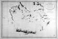 | Details | Depot de la Marine | 1827 |
| Southern Aegean Archipelago, Cyclades |
|
Depot de la Marine |
|
| 1827 |
| LOC:0 |
| $0.00 | Depot-de-la-Marine | Southern-Aegean-Archipelago--Cyclades | SOLD<br></br>
Antique French nautical chart of the coast and the islands of the Southern Aegean Sea from 1827 centered on the Cyclades islands with Crete, Greece ( Candie ) at bottom. Geographic features covered by this antique chart include these locations in Greece and Turkey: Athens, Corinth, Izmir ( "Smyrna" ), Kusadasi ( "Scala-Nova" ), Bodrum, the Cesme and Datca peninsulas, and the islands of: Chios, Delos, Kythira ( "Cerigo" ), also spelled Cythera, Kythera and Kithira ; Antikythira ( "Cerigotte" ), Mykonos, Santorini, Milos, Naxos, Rhodes, Kos, and Crete (and all the other islands surrounding).
<br></br>
This scarce chart was issued by the French Depot de la Marine. Attractive old engraved copperplate engraved chart documenting the tracks of the exploration of that area by Gauttier in 1818 and 1819. Extensive fine hachuring of coastal mountains, some soundings, and no interior details. Dated to 1827 at bottom of the oval cartouche. With the circular stamp of the Depot General de la Marine. Attribution reads: "Publiée par Ordre du Roi sous le Ministère de Son Excellence M. le Comte Chabrol de Crousol. Dépôt Générale de la Marine." |
| 599 | 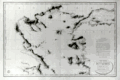 | Details | Depot de la Marine | 1827 |
| Northern Aegean Archipelago |
|
Depot de la Marine |
|
| 1827 |
| LOC:1403 |
| $1,750.00 | Depot-de-la-Marine | Northern-Aegean-Archipelago | Antique nautical chart of the coast and the islands of the northern Aegean Sea and the Sea of Marmara, including Constantinople, Turkey (modern Istanbul). Attractive old engraved chart documenting tracks of the exploration of that area. Extensive fine hachuring of coastal mountains, some soundings, and no interior details. At bottom of the inset 'avertissment' is found a legend dating each of the map's tracks to the year in which that exploration was conducted and identifying the abbreviations used by the authors for representing the composition of the sea bottom.
<br></br>
Geographical features covered by this antique chart include these locations in Greece and Turkey: Gulf of Corinth, Negroponte, Euboea ( the second largest Greek Island after Crete ), Skyros, Skiatos, Gulf of Salonica, the Dardanelles, Istanbul, Tenedos ( Bozcada ), Lemnos, Gulf of Smryne, Smyrne ( Smyrna ), Samos and much more.
<br></br>
An advertisement at right states that the chart is the result of hydrographic and geodesic work on land and aboard the gabare 'la Chevrette' during the years 1818 and 1819. <a href="https://fr.wikipedia.org/wiki/Gabare" target="_blank">A 'gabare'</a> is a French term for a three masted vessel of between 100 and 450 tons, typically used as a cargo carrier. Their heavy construction and capacity made them especially suitable for exploration and survey work.
<br></br>
Dated to 1827 at bottom of the oval cartouche. With the circular stamp of the Depot General de la Marine. Attribution reads: "Publiée par Ordre du Roi sous le Ministère de Son Excellence M. le Comte Chabrol de Crousol. Dépôt Générale de la Marine" Price when issued: two Francs. |
| 620 | 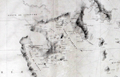 | Details | Depot de la Marine | 1827 |
| Southern Aegean Archipelago |
|
Depot de la Marine |
|
| 1827 |
| LOC:0 |
| | Depot-de-la-Marine | Southern-Aegean-Archipelago | SOLD
<BR></BR>
Antique French nautical chart of the coast and the islands of the Southern Aegean Sea from 1827. Geographic features covered by this antique chart include these locations in Greece and Turkey: Athens, Corinth, Izmir ( Smyrna ), Kusadasi ( Scala-Nova ), Bodrum, the Cesme and Datca peninsulas, and the islands of: Chios, Delos, Mykonos, Santorini, Milos, Naxos, Rhodes, Kos, and Crete ( Candia ). This scarce 'brownback' chart was issued by the French Depot de la Marine and was lined with brown linen when sold to provide additional protection from the elements onboard ship.<br></br>
Very interesting intact sellers label on the verso ( displayed bottom left corner ) reads : "MAISTRE. Ancien oeuvre d' Antoine Roux. Hydrographe. A l'honneur de Prevenir Mssrs. Les Armateurs et capitanes Marins qu'il confectionne et remet a neuf lous le Instrumens de marine. Quai Rive l'avenue. MARSEILLE. Pres le Pharmacien."<br></br>
Attractive old engraved chart documenting the tracks of the exploration of that area by Gauttier in 1818 and 1819. Extensive fine hachuring of coastal mountains, some soundings, and no interior details. Dated to 1827 at bottom of the oval cartouche. With the circular stamp of the Depot General de la Marine. Attribution reads: "Publiée par Ordre du Roi sous le Ministère de Son Excellence M. le Comte Chabrol de Crousol. Dépôt Générale de la Marine." |
| 598 |  | Details | Dezauche, A.G. | 1829 |
| Carte De la Grece ou Theatre de la Guerre Entre les Grecs et les Turcs |
|
Dezauche, A.G. |
|
| 1829 |
| LOC:0 |
| $0.00 | Dezauche--A-G- | Carte-De-la-Grece-ou-Theatre-de-la-Guerre-Entre-les-Grecs-et-les-Turcs | SOLD<br></br>Antique map of Greece and Turkey with the Aegean Sea and its archipelago of islands, the Sea of Marmara, and portions of the Adriatic and Black Seas. This map is specifically focused on the "Theater of War" during the<a href="http://www.britannica.com/EBchecked/topic/244575/War-of-Greek-Independence" target="_blank"> War of Greek Independence </a> ( from Turkey ) between 1821 and 1832.
<br></br>
Specific geographical features include the Greek islands of Corfu, Crete, Rhodes, Negropont (Euboea), and Santorini; cities of Preveza, Gallipoli, Athens, Salonique ( Thessalonika ); with Smyrne ( Izmir ) and Constantinople ( Istanbul ), Turkey.
<br></br>
This large beautifully engraved, steel-plate engraved antique map was originally produced ca. 1780 by the French cartographer and former "Ingenieur-Hydrographe de la Marine" A.G. Dezauche. This edition is a published by his son J.A. Dezauche from Paris in 1829.
<br></br> |
| 6391 |  | Details | Varvatis Brothers | 1962 |
| Very scarce pictorial map of Greece |
|
Varvatis Brothers |
|
| 1962 |
| LOC:150 |
| $500.00 | Varvatis-Brothers | Very-scarce-pictorial-map-of-Greece | Pictorial map of Greece. Scarce.
<br></br>
Produced by Hellenic Pictorial Cartography of Varvatis Brothers established 1930 Patent 10221 Copyright Varvatis Brothers.
<br></br>
Only one copy found in WorldCat, at BnF. |