| | Thumbnail | | Creator | Date | Title / Author / Date / Location | Price | | | Description |
| 8090 |  | Details | Feher, Joseph | 1950 |
| The Dole Map of the Hawaiian Islands |
|
Feher, Joseph |
|
| 1950 |
| LOC:63 |
| $575.00 | Feher--Joseph | The-Dole-Map-of-the-Hawaiian-Islands | Original lithographed pictorial map of the Hawaiian Islands copyrighted by the Hawaiian Pineapple Company Ltd. 1950. Overall width 40.5 inches. Lacking original legend at right. Pinholes in margins.
<br><br>
Artist Joseph Feher depicted the Hawaiian islands and adjacent waters with boats, fish, and typical objects and pursuits associated with the islands: flying fish, surfing, spear fishing, sailing, poi-making, hula dancers, etc. Islands of the State of Hawaii mentioned in the legend include: Kauai, Niihau, Oahu, Molokai, Lanai, Maui, Kahoolawe, and the big island- Hawaii.
<br></br>
This is the second of two "Dole Pineapple Maps", the first was published in 1937.
<br></br>
Lithography by Schwabacher-Frey.
<br></br>
Once known as the Sandwich Islands, the Hawaiian Islands first documented discovery by a westerner occurred in 1778 with the arrival of British explorer Captain James Cook.
<br></br> |
| 6701 | 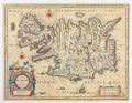 | Details | Blaeu, William Janszoon | 1650 |
| Tabula Islandiae Auctore Georgio Carolo Flandro |
|
Blaeu, William Janszoon |
|
| 1650 |
| LOC:86 |
| $700.00 | Blaeu--William-Janszoon | Tabula-Islandiae-Auctore-Georgio-Carolo-Flandro | A fine 17th century map of Iceland priced to sell.
<br><br>
This map of Iceland, "Tabula Islandiae Auctore Georgio Carolo Flandro", was engraved for William Janszoon Blaeu and first published in his firm’s Atlas Novus. The plate is based on surveys by the Dutch navigator Georgius Carolus Flandrus (Joris Carolus), one of the few early European seafarers to chart northern waters. The map depicts Iceland with stylized mountain ranges, rivers, and settlements identified in Latin and Icelandic. Surrounding seas are filled with ships and sea creatures, and a large title cartouche occupies the lower right. The imprint “Guiljelmus Blaeuw” identifies the plate as one originally engraved for Willem before his death in 1638.
<br><br>
The verso text, printed in Dutch, places this example within the early Dutch-language edition of the Toonneel des Aerdrycks issued in Amsterdam around 1648–1650, when the Blaeu firm was transitioning from William to his son Joan. Printed from the original copperplate, this state retains the strong, clean impression of the earliest issues and represents one of the most well known mid seventeenth-century maps of Iceland. The map’s enduring design remained in use for more than two decades and set the cartographic standard for the island until the late eighteenth century.
<br><br> |
| 7991 | 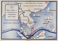 | Details | Wehrmacht Propaganda Service | 1942 |
| German WWII propaganda poster Japanese capture of Singapore |
|
Wehrmacht Propaganda Service |
|
| 1942 |
| LOC:130 |
| $450.00 | Wehrmacht-Propaganda-Service | German-WWII-propaganda-poster-Japanese-capture-of-Singapore | Scarce German propaganda poster from World War II produced by the Wehrmacht Propaganda Service following the fall of Singapore in February 1942. Once considered the “Gibraltar of the East,” Singapore’s swift collapse to Japanese forces was seized upon by German propagandists to ridicule Britain’s waning imperial power and the failure of Allied defenses in Asia.
<br><br>
Titled “Singapura em poder dos japoneses,” the poster presents four scenes of Japanese troops advancing through jungle terrain, tanks on the move, and aircraft strafing the island’s airfields. At the center, a map dramatizes the Allied supply routes to Singapore being severed—depicted with a pair of scissors—and highlights captured British and American bases throughout the South China Sea, the Philippines, and Malaya, symbolizing the Axis narrative of unstoppable Japanese expansion.<br></br>
Only two examples of this poster are found in WorldCat.
<br><br>
At bottom: "A castello forte britanico na Grande Asia foi desbarratado Churchill e Roosevelt tambem ali perderam a jogo" reflecting the magnitude and impact of the defeat.
<br></br>
Verso with Portuguese text related to Singapore and details of the conflict in Asia.
<br></br> |
| 7987 |  | Details | Harrison, John | 1784 |
| A New Chart of the Sandwich Islands including oWhyhee Hawaii |
|
Harrison, John |
|
| 1784 |
| LOC:130 |
| $1,100.00 | Harrison--John | A-New-Chart-of-the-Sandwich-Islands-including-oWhyhee-Hawaii | Engraved chart of the Hawaiian Islands issued shortly after the publication of the official account of Captain Cook’s third voyage (James King; June, 1784). This chart was published one month later in London by Harrison & Co., on July 1, 1784. It traces the routes of Cook’s ships Resolution and Discovery through the Hawaiian archipelago and highlights “oWhyhee” (Hawaiʻi), where Cook met his death in February 1779.
<br><br>
Based closely on Henry Roberts’ official chart but without the inset of Kealakekua Bay, Harrison’s version was created for a popular audience eager for news of the famous explorer’s final journey.
The map offers one of the earliest separately issued depictions of the Hawaiian Islands, capturing the moment when they first entered European geographic consciousness.
<br><br>
Printed from a finely engraved copper plate, the chart combines geographic accuracy with contemporary drama, naming each island and noting Cook’s fatal landing. Examples of this edition are far scarcer than those bound in the official voyage atlas, making it a sought-after piece for collectors of Pacific exploration and early Hawaiian cartography.
<br><br> |
| 7979 | 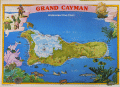 | Details | International Map Services Ltd. | 1975 |
| Grand Cayman Island Underwater Dive Chart |
|
International Map Services Ltd. |
|
| 1975 |
| LOC:86 |
| $175.00 | International-Map-Services-Ltd- | Grand-Cayman-Island-Underwater-Dive-Chart | Unrecorded fine pirate-themed chart of underwater dive sites in the Cayman Island ca. 1975.
Grand Cayman is the largest of the three Cayman Islands, which are a British Overseas Territory in the western Caribbean Sea. The map is specifically an "Underwater Dive Chart," highlighting various dive sites, dive shops and marine life around the island.
<br><br>
Some of the many dive sites noted include: New Tarpon Alley, Hepps Pipeline, Pinnacle Rock, Bonnie's Arch, Oro Verde Wreck, Balboa Wreck, Japanese Gardens, and East End Reefs.
<br><br>
Also noted is Bob Soto's diving shop. Bob Soto (1926–2015), known as the “Father of Diving” in the Cayman Islands, died at age 88, prompting dive flags to fly at half-mast across the islands. He founded recreational scuba diving in the Cayman Islands when he opened the first dive shop on George Town’s waterfront in 1957, starting with one wooden boat, several tanks, and a small staff he personally trained. Soto’s pioneering efforts created the foundation of Cayman’s world-renowned dive industry, mentoring many of today’s dive leaders.
<br><br>
Copyright International Map Services Ltd. P.O. Box 2187. Cayman Islands, B.W.I. "International Map Services Ltd." was a small company based in George Town, Grand Cayman, Cayman Islands, and was involved in the map publishing industry. |
| 7917 | 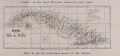 | Details | Ricoy, M. | 1896 |
| Mapa de la Isla de Cuba |
|
Ricoy, M. |
|
| 1896 |
| LOC: |
| $200.00 | Ricoy--M- | Mapa-de-la-Isla-de-Cuba | Promotional map of Cuba issued in 1896 to advertise “Cuba” brand Havana cigarettes, with the slogan “Cuba is the best Havana cigarette ever made.” The map shows the island’s provinces, towns, roads, railways, and lighthouses, with a legend identifying provincial capitals, judicial districts, and rail lines under construction. Printed in Havana by M. Ricoy during the final years of Spanish colonial rule, the map reflects the geography of Cuba on the eve of the Spanish–American War. |
| 7893 | 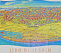 | Details | Oberbacher, Hans | 1958 |
| Lido di Jesolo beach near Venice Italy |
|
Oberbacher, Hans |
|
| 1958 |
| LOC:86 |
| $255.00 | Oberbacher--Hans | Lido-di-Jesolo-beach-near-Venice-Italy | Fine birds-eye view, "Lido di Jesolo", with Venice, Italy at the left. By Hans Oberbacher. 1958.
<br><br>
Lido di Jesolo, a popular seaside resort town, is situated within the metropolitan city of Venice, Italy. It is well known for its long sandy beach and vibrant nightlife, and it serves as a popular tourist destination, especially during the summer months. Lido di Jesolo is situated on the Adriatic coast close to Venice, making it a convenient location for visitors looking to enjoy both the beach and the historic city of Venice.
<br><br>
The region surrounding Jesolo has been featured in cartographic works dating back to the 14th century or earlier, crafted by renowned cartographers such as Pietro Vesconte, Fra Mauro, Benedetto Bordone, and Vincenzo Maria Coronelli, among others. These prior charts provide insight into the development of the Venetian Lagoon over time.
<br><br>
Jesolo has a history that dates back to ancient Roman times when it was known as Equilium, meaning "city of horses." The area was largely abandoned during the Middle Ages due to the decline of the Roman Empire and encroachment of the surrounding marshlands.
<br><br>
During the era of the Republic of Venice, which lasted from the 8th to the 18th century, the Venetians began to drain and reclaim the land for agriculture and fishing. The first settlements were established in the 19th century, and the town was renamed Cavazuccherina.
<br><br>
The opening of the first beach resort in 1911 marked the beginning of tourism in Lido di Jesolo. However, it was not until the post-World War II period that the town experienced a significant boom in tourism. During the 1950s and 1960s, rapid development and urbanization transformed Lido di Jesolo into one of the most popular seaside resorts in Italy. |
| 7895 | 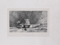 | Details | le Breton, Louis | 1842 |
| Double pirouge in its shed |
|
le Breton, Louis |
|
| 1842 |
| LOC: |
| $200.00 | le-Breton--Louis | Double-pirouge-in-its-shed | Louis Le Breton's lithograph titled "Pirogue double sous son hangar" (which translates to "Double pirogue under its shed") appears in the book "Voyage au pôle Sud et dans l'Océanie sur les corvettes l'Astrolabe et la Zélée" (Voyage to the South Pole and Oceania on the corvettes Astrolabe and Zélée). This book, published in 1841, documents the French naval expedition led by Jules Dumont d'Urville from 1837 to 1840.
<br><br>
The expedition aimed to explore the South Pacific Ocean and the Antarctic region. Le Breton served as a naval surgeon and artist on that expedition, creating numerous illustrations and engravings that were later included in the published account of the voyage. The engraving "Pirogue double sous son hangar" depicts a traditional double canoe (pirogue) from Oceania under a protective shed.
<br><br>
Lithograph by P. Blanchard and printed by Thierry Freres, Paris. |
| 7877 | 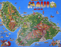 | Details | Island Funnies | 1990 |
| Cute Pictorial Map Poster of Maui, Hawaii |
|
Island Funnies |
|
| 1990 |
| LOC:130 |
| $195.00 | Island-Funnies | Cute-Pictorial-Map-Poster-of-Maui--Hawaii | <br><br>
Cute pictorial map poster of Maui, Hawaii by Island Funnies (1990) - licensee of Fiesta Cartoon Maps. The map highlights local parks and recreational activities including scuba diving, golf, fishing, sailing, and surfing.
<br><br>
Maui, the second-largest island in Hawaii, has a rich history dating back to ancient Polynesian settlers. The island was first settled by Polynesians who navigated the Pacific Ocean using the stars, arriving in Hawaii around 400-800 AD. These early settlers developed a complex society with a strict social hierarchy and a subsistence economy based on fishing and agriculture.
<br><br>
In the late 18th century, European explorers arrived in Hawaii, with Captain James Cook being the first recorded European to visit Maui in 1778. The island later became a center for the whaling industry and a popular port for ships traveling between North America and Asia.
<br><br>
Lahaina, located on the west coast of Maui, was once the capital of the Hawaiian Kingdom in the early 19th century. It was also a major whaling port and a center of commerce. Today, Lahaina is a popular tourist destination known for its historic buildings, art galleries, and restaurants.
<br><br>
Kapalua, situated on the northwest coast of Maui, was once a plantation growing pineapples and coffee. In the 1970s, the area was transformed into a resort destination featuring world-class golf courses, luxurious accommodations, and pristine beaches.
<br><br>
Haleakala, a massive shield volcano that forms the eastern portion of Maui, is a significant feature of the island. The volcano's crater is a popular destination for hiking, stargazing, and watching the sunrise. In 1916, Haleakala National Park was established to protect the unique volcanic landscape and the endemic species that inhabit the area.
<br><br> |
| 7881 | 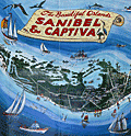 | Details | Hancock, W. Harold | 1980 |
| Pictorial Map Sanibel Captiva Islands Florida |
|
Hancock, W. Harold |
|
| 1980 |
| LOC:130 |
| $195.00 | Hancock--W--Harold | Pictorial-Map-Sanibel-Captiva-Islands-Florida | Attractive pictorial poster map of Sanibel and Captiva Islands in Florida from circa 1980. Drawn by artist William Harold Hancock (1920-2006).
<br><br>
Sanibel Island, a beautiful barrier island located off the coast of Fort Myers in Florida, is known for its stunning beaches, lush wildlife, and laid-back atmosphere. The island is home to the J.N. "Ding" Darling National Wildlife Refuge, a 5,200-acre sanctuary that protects mangrove forests, seagrass beds, and a diverse array of bird species. Visitors can explore the sanctuary by hiking, biking, or taking a guided tour, offering a chance to appreciate the island's natural beauty and observe wildlife in their natural habitat.
<br><br>
The island's marinas, such as Tarpon Bay Marina and Sanibel Marina, serve as gateways to the surrounding waters, providing access to fishing charters, boat rentals, and eco-tours. The Island Belle, a popular excursion boat, offers visitors the opportunity to explore the waters around Sanibel and Captiva Islands, showcasing the area's diverse marine life, including dolphins, manatees, and a variety of fish species.
<br><br>
For those seeking a more luxurious experience, Casa Ybel Resort offers beachfront accommodations, fine dining, and a range of activities, including golf, tennis, and spa treatments. The resort's location on the southern end of Sanibel Island provides easy access to the island's top attractions, such as the Sanibel Lighthouse and the Bailey-Matthews National Shell Museum. With its combination of natural beauty, outdoor activities, and upscale amenities, Sanibel Island is a perfect destination for those looking to escape the hustle and bustle of everyday life and immerse themselves in the tranquility of Florida's Gulf Coast.
<br><br> |
| 8088 |  | Details | Suchy, Arthur Bartholomew | 1940 |
| Stunning Map Cayo Hueso Key West Florida Collectors Edition |
|
Suchy, Arthur Bartholomew |
|
| 1940 |
| LOC:141 |
| $875.00 | Suchy--Arthur-Bartholomew | Stunning-Map-Cayo-Hueso-Key-West-Florida-Collectors-Edition | Large original Arthur Suchy pictorial birds-eye map of Cayo Hueso or Key West, Florida. Printed in black ink. Designed, executed, produced and first copyrighted by Arthur Suchy ca. 1938. Purchased from Suchy's estate liquidation. Watermarked "Linweave TEXT Made in USA". Rarely have we seen a map of this age in such pristine condition.
<br><br>
Suchy identifies alphabetically and numerically over 70 locations that surround the view including:
<div class="indenttextblocksingle">
<ul style="list-style-type: circle;"></li>
<li>Cigar factories</li>
<li>P.A.A. Airport</li>
<li>Turtle crawls</li>
<li>Fish market</li>
<li>Warbler (helpful tug)</li>
<li>Pepe's coffee shop</li>
<li>Delmonico's</li>
<li>Key West radio station</li>
</ul>
</div>
Arthur Bartholomew Suchy (1901 - 1995) produced two editions of his famous map of Cayo Hueso- this, the first larger-size Collectors Edition was produced in a limited quantity of 100 copies dated to 1940. As Suchy received orders for the maps he would hand color each map before shipment.
<br><br>
The second and smaller edition was printed in red ink to 1941. [1] Includes numerous historical notes about Key West.
<br><br>
Suchy was issued a copyright for the Collectors Edition on Dec. 14, 1938.
<br><br>
[1] David Rumsey Map Collection at Stanford University Libraries |
| 6771 |  | Details | Touanne, Edmund Bigot de la | 1837 |
| Bougainville elevation views Port Jackson Rio de Janiero Da Nang Hainan Macao |
|
Touanne, Edmund Bigot de la |
|
| 1837 |
| LOC:130 |
| $800.00 | Touanne--Edmund-Bigot-de-la | Bougainville-elevation-views-Port-Jackson-Rio-de-Janiero-Da-Nang-Hainan-Macao | Sheet of coastal elevation views after drawings by Edmund Bigot de la Touanne (1796-1863) and engraved by Ambroise Tardieu (1) for "Journal de la navigation autour du globe de la Fregate la Thetis et de la corvette l 'Esperance." That journal documents the circumnavigation of Bougainville (2) during 1824 through 1826 aboard the Thetis and Esperance.
<br><br>
Plate 54. 1837.
<br><br>
The coasts depicted include the Philippine Island of Luzon; Guangzhou (Canton) China; Macao, China; Hainan, China; Da Nang, Vietnam; Lombok, Indonesia; Surabaya, Indonesia; Sydney, Australia; and Rio de Janeiro, Brazil. Descriptions of the views are translated here from the original text in French:
<div class="indenttextblocksingle">
<ul style="list-style-type: decimal;">
<li>Vue d'une partie de la cote Nord-Ouest de I'lle Lucon (Philippines) prise le 20 Decembre 1824</li>
<li>Vues de Piedra Branca a l'atterage du Golfe de Canton (Chine) prises le 24 December 1824</li>
<li>Vue du passage de Lantao a l'entree du Golfe de Canton (Chine) prises le 24 December 1824</li>
<li>Vue de la Ville de Macao (Chine) prises en Janvier 1825</li>
<li>Vue d'une partie de la cote est de I'lle d'Hainan (Chine) prises le 10 Janvier 1825</li>
<li>Vue de l'Entree de la Baie de Tourane (Cochinchine) prise le a Janvier 1825</li>
<li>Vue du Mouillage de Tourane (Cochinchine) prise en Fevrier 1825</li>
<li>Vue de I'lle Lombock (Archipel de al Sonde) prise le 10 Mai 1825</li>
<li>Vue de la Rade de Sourabaya a l'est de Java (Archipel de la Sonde) prise en Avril 1825</li>
<li>Vu de la Ville de Sidney au Port Jackson (Nouvelle Galles Meridionale) prise en Aout 1825</li>
<li>Vue de l'Entrée de la Baie de Rio Janeiro(Bresil) prise le Avril 1828.</li>
</ul>
</div> |
| 6735 | 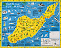 | Details | Ramsey, George | 1947 |
| Scarce pictorial fun map of Santa Catalina Island |
|
Ramsey, George |
|
| 1947 |
| LOC:89 |
| $295.00 | Ramsey--George | Scarce-pictorial-fun-map-of-Santa-Catalina-Island | <br><div class="indenttextblocksingle"><b>For a lasting remembrance of a grand vacation!</b> Keep this souvenir fun-map and mark the points you visit and the dates. Trace the routes of your travels on Catalina. Send copies to friends</div>
<br><br>
Where to go - What to see Santa Catalina Island fun map. A post-WWII pictorial map of Catalina Island, California. Copyright by George Ramsey. Published 1947 by Recreation Publishing Company, Los Angeles, CA. Price when issued 25 cents. Features include: Location of Ling-Ho Chinese junk movie set; Seal Rocks; submarine gardens; Chicago Cubs Ball Park and training grounds; the Catalina Visitors Country Club and much more.
<br><br>
Verso with map for Avalon Town |
| 6704 |  | Details | Mannevillette, d'Apres | 1775 |
| Chart of the east coast of Madagascar |
|
Mannevillette, d'Apres |
|
| 1775 |
| LOC:68 |
| $475.00 | Mannevillette--d-Apres | Chart-of-the-east-coast-of-Madagascar | Original French nautical chart of a portion of the east coast of the island of Madagascar, off the east coast of Africa. From the second edition of Le Neptune Oriental published 1775 in Paris.
<br><br>
The most prominent feature of the chart is Antongil Bay, a large bay located on the northeast coast of Madagascar. The bay is known for its beautiful beaches, rich biodiversity, and important fishing industry. The surrounding area is also home to several protected areas, including the Masoala National Park and the Nosy Mangabe Special Reserve.
<br><br>
Antongil Bay has a rich history dating back to the early days of Madagascar's settlement by humans. The bay was a major center of trade and commerce for the island's indigenous populations, who used it to transport goods and communicate with other communities along the coast.
<br><br>
During the colonial period, Antongil Bay became an important center of trade for the French, who established several ports along its shores. The bay was used to transport goods such as vanilla, cloves, and other spices, which were grown on plantations throughout the region
<br><br>
The chart includes large-scale inset plans for the following bays and anchorages:
<div class="indenttextblocksingle">
<ul style="list-style-type: circle;"></li>
<li>Plan de l'Ance de Tamatave</li>
<li>Plan de l'Anse de Veninguebe</li>
<li>Plan du Port de Teintingue</li>
<li>Plan de la Rade de Fullpointe</li>
</ul>
</div> |
| 6703 |  | Details | Prevoteau, Gerard | 1980 |
| Pictorial Map Aruba Pearl in the Caribbean |
|
Prevoteau, Gerard |
|
| 1980 |
| LOC:51 |
| $350.00 | Prevoteau--Gerard | Pictorial-Map-Aruba-Pearl-in-the-Caribbean | Very scarce out-of-print advertising-oriented pictorial map, circa 1980, of the island of Aruba in the Caribbean Sea. Illustrated by Gerard Prevoteau and published by Imprimerie Berger-Bellepage, Fort de France, Martinique (1). Prevoteau is known to have created more than thirty illustrations of towns and islands including Reims, the isle of Oleron, and a pair of maps or plans of the French town of St. Malo, France. Not in WorldCat.
<br><br>
Captions for many illustrations in either Dutch, English, or Spanish.
<br><br>
Aruba is a small Caribbean island located just off the coast of Venezuela. The island has a rich history, having been inhabited by indigenous tribes before being colonized by the Spanish in the 16th century. Today, Aruba is an autonomous territory of the Netherlands, and its culture is a unique blend of Dutch, Caribbean, and Latin American influences. Aruba is known for its beautiful beaches and also boasts a variety of outdoor activities, including snorkeling, scuba diving, hiking, and horseback riding. The island is also home to a number of historic landmarks and cultural attractions, including the California Lighthouse, the Arikok National Park, and the vibrant capital city of Oranjestad.
<br><br>
(1) Berger Bellepage company was created on August 1st, 1964, and it is one of the oldest printing companies in Martinique. The current printing facility has been located in Fort-de-France since 1969. |
| 6676 |  | Details | Coolidge, P.T. | 1926 |
| Manuscript forest stand map south Allen's Island St George Maine Wyeth |
|
Coolidge, P.T. |
|
| 1926 |
| LOC:86 |
| $350.00 | Coolidge--P-T- | Manuscript-forest-stand-map-south-Allen-s-Island-St-George-Maine-Wyeth | Rare pen and ink manuscript forestry stand map of the south part of Allen's (Allen) Island, Maine. The map was created to represent the vegetation type, stand density and species distribution for South Allen Island in 1924. A century ago spruce predominated at the south end with pasture and scrub growth surrounding an old farm near island center.
<br><br>
Allen Island is a 450-acre private island located in St. George, Knox County, Maine. Situated near the southeastern end of Muscongus Bay, it is the largest island of a small cluster, with Benner Island to the northwest and Burnt Island to the east.
<br><br>
According to historical records, the island was first granted to William Allen, a prominent businessman and politician in Massachusetts, in the mid-18th century. Allen used the island primarily for fishing and hunting, and it remained in his family for several generations. In 1979, the island was purchased by Betsy Wyeth, wife of painter Andrew Wyeth. Prior to their ownership, the island had become a seasonal home for two fishing families living in decaying houses on the fringe of a fast-encroaching spruce forest.
<br><br>
<div id="0" align="center">
<a title=""></a> <img id="3" src="/zoomifyimages/SC_6676/SC_6676_Island.jpg" alt="Allen Island, Maine." width="300"/> <br><small>Allen Island, Maine courtesy Colby College.</small>
</div><br>
Wyeth was drawn to the island's stark natural beauty and solitude, which he found to be a perfect place for inspiration and artistic creation. He spent much of his time on the island, painting the landscape as well as the old decaying houses and structures that dotted the island's coastline. Many of his paintings featuring the island's landscape are considered to be among his most iconic works. |
| 6640 | 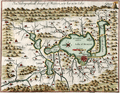 | Details | Gemelli Carreri, Giovanni Francesco | 1704 |
| Early map of Mexico City with Lakes and Causeways by Gemelli |
|
Gemelli Carreri, Giovanni Francesco |
|
| 1704 |
| LOC:3 |
| $525.00 | Gemelli-Carreri--Giovanni-Francesco | Early-map-of-Mexico-City-with-Lakes-and-Causeways-by-Gemelli | Original, copper-plate engraved and hand-colored map of the Valley of Mexico by Giovanni Francesco Gemelli Carreri (Gemelli) after Enrico Martinez and Adrian Boot (1). Scarce. North is oriented to the left.
<br><br>
Shows lakes, rivers, streams, and mountains in the Valley of Mexico along with numerous villages and towns. Nascent Mexico City or Tenochtitlán, is shown to lie in lower Lake Texcoco connected to the mainland by seven causeways. From an English-language publication of A Voyage Around the World (1699), probably A. and J. Churchill, 1704.
<br><br>
(1) Connolly, Patricia and Roberto Mayer. Vingboons, Trasmonte and Boot: European Cartography of Mexican Cities in Early Seventeenth Century. Imago Mundi. January, 2009. |
| 6643 | 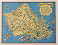 | Details | White, Ruth Taylor | 1931 |
| Pictorial map of the Island of Oahu in Hawaii |
|
White, Ruth Taylor |
|
| 1931 |
| LOC:89 |
| $200.00 | White--Ruth-Taylor | Pictorial-map-of-the-Island-of-Oahu-in-Hawaii | Fine lithographed cartograph or pictorial map of the island of Oahu, Hawaii by Ruth Taylor White. In 1931 White produced four maps of individual islands for the Hawaii Tourist Bureau: Kauai, Maui, Hawaii, Oahu, and one map of the entire Hawaiian Island chain. Printed by the Honolulu Star-Bulletin.
<br><br>
Locations and features that White captured on her map of Oahu include:"
<div class="indenttextblocksingle">
<ul style="list-style-type: circle;"></li>
<li>Waimea Falls</li>
<li>Kaneohe Bay</li>
<li>Kailua Bay</li>
<li>Diamond Head</li>
<li>Waikiki Beach</li>
<li>Honolulu</li>
<li>Pearl Harbor</li>
<li>Koko Head</li>
</ul>
</div> |
| 6644 | 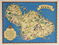 | Details | White, Ruth Taylor | 1931 |
| Pictorial map of the island of Maui in Hawaii |
|
White, Ruth Taylor |
|
| 1931 |
| LOC:89 |
| $250.00 | White--Ruth-Taylor | Pictorial-map-of-the-island-of-Maui-in-Hawaii | Fine lithographed cartograph or pictorial map of the island of Maui, Hawaii by Ruth Taylor White. In 1931 White produced four maps of individual islands for the Hawaii Tourist Bureau: Kauai, Maui, Hawaii, Oahu, and one map of the entire Hawaiian Island chain. Printed by the Honolulu Star-Bulletin.
<br><br>
Locations and activities that White featured on her map of Maui include:"
<div class="indenttextblocksingle">
<ul style="list-style-type: circle;"></li>
<li>Lahaina</li>
<li>Kaanapali</li>
<li>Kahului Harbor</li>
<li>Hana</li>
<li>Kipahuhu</li>
<li>Molokini</li>
<li>Makena</li>
<li>Wailuku</li>
</ul>
</div> |
| 6645 | 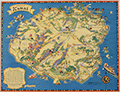 | Details | White, Ruth Taylor | 1931 |
| Pictorial map of the island of Kauai in Hawaii Polynesia |
|
White, Ruth Taylor |
|
| 1931 |
| LOC:89 |
| $250.00 | White--Ruth-Taylor | Pictorial-map-of-the-island-of-Kauai-in-Hawaii-Polynesia | Fine lithographed cartograph or pictorial map of the Polynesian island of Kauai, Hawaii by Ruth Taylor White. In 1931 White produced four maps of individual islands for the Hawaii Tourist Bureau: Kauai, Maui, Hawaii, Oahu, and one map of the entire Hawaiian Island chain. Printed by the Honolulu Star-Bulletin.
<br><br>
Locations and activities that White featured in her map of the Island of Kauai include:"
<div class="indenttextblocksingle">
<ul style="list-style-type: circle;"></li>
<li>Barking Sands</li>
<li>Napali Coast</li>
<li>Hanalei Beach</li>
<li>Moloaa</li>
<li>Nawiliwili Harbor</li>
<li>Port Allen</li>
<li>Ruins of Russian Port</li>
<li>Waimea</li>
</ul>
</div> |
| 6646 | 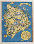 | Details | White, Ruth Taylor | 1931 |
| Pictorial map of the Island of Hawaii |
|
White, Ruth Taylor |
|
| 1931 |
| LOC:89 |
| $200.00 | White--Ruth-Taylor | Pictorial-map-of-the-Island-of-Hawaii | Fine lithographed cartograph or pictorial map of the island of Hawaii by Ruth Taylor White. In 1931 White produced four maps of individual islands for the Hawaii Tourist Bureau: Kauai, Maui, Hawaii, Oahu, and one map of the entire Hawaiian Island chain. Printed by the Honolulu Star-Bulletin.
<br><br>
Locations and features that White featured in her map of Hawaii include:"
<div class="indenttextblocksingle">
<ul style="list-style-type: circle;"></li>
<li>Mauna Kea</li>
<li>Mauna Loa</li>
<li>Kilauea</li>
<li>Hilo</li>
<li>Kealakekua Bay</li>
<li>Kailua</li>
<li>Upolu Point</li>
<li>Hookena</li>
<li>Hoopuloa</li>
</ul>
</div> |
| 6499 | 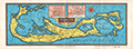 | Details | Anonymous | 1939 |
| Fine colorful map of Bermuda ca. 1939. |
|
Anonymous |
|
| 1939 |
| LOC:90 |
| $125.00 | Anonymous | Fine-colorful-map-of-Bermuda-ca--1939- | An original and very attractive 7"x21" pictorial map of the Bermuda Islands on the recto of a folding promotional brochure for Bermuda in four panels. Numerous simple realistic sketches depict locations that include:
<div class="indenttextblocksingle">
<ul style="list-style-type: circle;">
<li>Ireland Island</li>
<li>Gibbs Hill Lighthouse</li>
<li>St. Paul's Church</li>
<li>Military Barrack Prospect</li>
<li>Harrington Sound</li>
<li>Tucker's Town</li>
<li>Shelly Bay Race Track</li>
<li>St. George</li>
<li>St. Catherines Point</li>
</ul>
</div>Inset street plans for St. George and for Hamilton. North oriented at upper right with a fine colorful compass rose. Text below the map includes latitude and longitude coordinates for Bermuda and a scale of miles.
<br><br>
The verso contains photos and text related to steamship service to Bermuda from several maritime firms including:
<ul style="list-style-type: circle;">
<div class="indenttextblocksingle">
<ul style="list-style-type: circle;"></li>
<li>The Furness Bermuda Line</li>
<li>The Pacific Steam Navigation Company</li>
<li>The Munson Steamship Lines</li>
<li>The Canadian National Steamships</li>
<li>Elders & Fyffes, Ltd.</li>
<li>New York Bermuda Lines</li>
</ul>
</div> |
| 6491 | 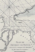 | Details | Mannevillette, d'Apres | 1775 |
| Antique nautical chart of the Bangka or Banca Strait |
|
Mannevillette, d'Apres |
|
| 1775 |
| LOC:90 |
| $250.00 | Mannevillette--d-Apres | Antique-nautical-chart-of-the-Bangka-or-Banca-Strait | Antique nautical chart of the Detroit du Banca or Bangka Strait from 1775 by Jean-Baptiste-Nicolas-Denis D’ Après de Mannevillette (1707 – 1780). Inset chart of a smaller strait between the Isle de Sel and part of Biliton Island or Belitung Island. That strait lies approximately 70 miles to the east of south Bangka Island.
<br><br>
The map is particularly interesting historically as it incorporates paste-over corrections to the eastern portion of the Isle de Banca with the previously charted coastline still faintly visible beneath the corrections. According to a pasted note at bottom left, the pasted corrections to the northeast of Bangka Island were based on the observations of M. Crozet. Julien Crozet was second in command during the French expedition of Marion De Fresne to Tasmania, New Zealand, and the South Pacific, sailing in 1771. Crozet assumed command of the expedition after the voyage's commander, Marion De Fresne, and 26 crew members were killed by the Maori Ngare Raumati tribe off the coast of New Zealand in June 1772.
<br><br>
Bangka Strait is the narrow body of water that separates the island of Sumatra from the Indonesian island of Bangka. Bangka is one of the world's most important tin-producing areas. |
| 6472 | 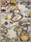 | Details | Shurtleff, Elizabeth | 1927 |
| Rare pictorial map of the Isle of Shoals |
|
Shurtleff, Elizabeth |
|
| 1927 |
| LOC:53 |
| $2,100.00 | Shurtleff--Elizabeth | Rare-pictorial-map-of-the-Isle-of-Shoals | Very rare original full-color lithographed pictorial map of the Isle of Shoals from 1927 designed and drawn by Elizabeth Shurtleff. Copyright by Jessie E. Donahue (1927). Beautiful, saturated colors. With verse by Celia Thaxter and Frederick T McGill.
<br><br>
Only two copies of Elizabeth Shurtleff's 1927 map of the Isle of Shoals were found in WorldCat. No record of a sale of the map was found online. A later much-revised edition of the Shurtleff's map was copyrighted and published in 1960 by Edward Rowe Snow.
<br><br>
Captain John Smith discovered the Isle of Shoals in 1664 lying about seven miles offshore on the border of what are today the states of New Hampshire and Maine. |
| 6470 | 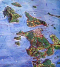 | Details | Pargeter, Richard Arnold | 1980 |
| Pictorial oblique topographic birds-eye view of the San Juan Islands |
|
Pargeter, Richard Arnold |
|
| 1980 |
| LOC:150 |
| $450.00 | Pargeter--Richard-Arnold | Pictorial-oblique-topographic-birds-eye-view-of-the-San-Juan-Islands | An original fine panoramic relief map of the San Juan Islands in Washington State on an oblique perspective. Copyright 1980 by Richard Pargeter. Printed by University Printing Company, Seattle. Pencil stock number in bottom right margin.
<br><br>
A self-taught cartographic illustrator, Pargeter's output includes similar panoramic relief maps of The Olympic Peaks, the Puget Sound Country, and Washington's Northwest Passages. In 1980, when this map was copyrighted, copies were available by mail-order from the Pargeter Company in Kent, Washington. Pargeter's maps were once available online but all available copies are reported as sold-out.
<br><br>
<div class="indenttextblocksingle">
"Tens of thousands of these maps have been sold over the years. All Pargeter's maps are true oblique projections. No planimetrics. All, but the pre-color-separated Olympic map have been full-color halftone shaded relief illustrations rendered in acrylics and a very fine brush, The renderings are based on U.S.G.S. topo quads with mountain "facial features" derived from aerial oblique angle photos taken by Pargeter". [1]
</div><br>
Source
<br><br>
[1] Online: Panorama maps. Pargeter. Online: http://www.panorama-map.com/pargeter/pargeter.html |
| 6697 |  | Details | Lepper, Ruth Rhoads | 1977 |
| Pictorial Map Maine Coast Between Casco Bay Penobscot Bay Lepper |
|
Lepper, Ruth Rhoads |
|
| 1977 |
| LOC:87 |
| $450.00 | Lepper--Ruth-Rhoads | Pictorial-Map-Maine-Coast-Between-Casco-Bay-Penobscot-Bay-Lepper | A Map of the Maine Coast Between Casco and Penobscot Bays made and published circa 1977 by Ruth Rhoads Lepper, West Southport, Maine. The prominent compass rose topped by a fleur-de-lis is a signature feature of Ruth Lepper pictorial maps and in this case is uncolored. Geographic coverage includes only those areas of the Maine Coast between Casco Bay and Penobscot Bay.
<br><br>
Map is dated with reference to a very similar larger-scale map held at the Osher Library: The Maine Coast from Kittery to Cape Elizabeth."
<br><br>
Lepper included brief facts on her coastal maps related to local maritime history:
<div class="indenttextblocksingle">
<ul style="list-style-type: circle;">
<li>On September 5, 1813, the U.S. brig. 'ENTERPRISE' captured the British brig. 'BOXER' The battle was fought in these waters. Both captains were killed.</li>
<li>Dixie Bull, the pirate. sailed into Pemaquid- In 1632. He sacked the trading post & dwellings, carrying away booty amounting to 2500.</li>
<li>The Virginia, first ship built by Englishmen on this Continent, was launched at Popham in 1608.</li>
<li>Allen's Island - Aug. 9,1607 Colonists from "Gift of God" & "Mary & John" listen to a sermon of Thanksgiving -the first English service on New England soil.</li>
</ul>
</div> |
| 6423 | 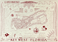 | Details | Suchy, Arthur Bartholomew | 1941 |
| Cayo Hueso or Key West Florida Second Edition |
|
Suchy, Arthur Bartholomew |
|
| 1941 |
| LOC:87 |
| $375.00 | Suchy--Arthur-Bartholomew | Cayo-Hueso--or-Key-West-Florida-Second-Edition | Stunning original second-edition pictorial birds-eye map of Cayo Hueso or Key West, Florida. Printed as designed in red ink. Designed, executed, produced and copyrighted by Arthur Suchy ca. 1941. Excellent detail on over 70 key locations that Suchy identifies alphabetically and numerically on a key that surrounds the view including:
<div class="indenttextblocksingle">
<ul style="list-style-type: circle;"></li>
<li>Cigar factories</li>
<li>P.A.A. Airport</li>
<li>Turtle crawls</li>
<li>Fish market</li>
<li>Warbler (helpful tug)</li>
<li>Pepe's coffee shop</li>
<li>Delmonico's</li>
<li>Key West radio station</li>
</ul>
</div>
Arthur Bartholomew Suchy (1901 - 1995) produced two editions of his famous map of Cayo Hueso- the first edition, larger and with full hand color was produced in a limited edition of 100 copies dated to 1940 and the second and smaller edition printed in red ink to 1941. [1] Includes numerous historical notes about Key West.
<br><br>
Suchy was issued a copyright for the collectors edition on Dec. 14, 1938. He filed a renewal application on Nov. 17, 1966.
<br><br>
[1] David Rumsey Map Collection at Stanford University Libraries |
| 6385 |  | Details | Lepper, Ruth Rhoads | 1965 |
| Pictorial Map of the Maine Coast from Rockland Schoodic Corea |
|
Lepper, Ruth Rhoads |
|
| 1965 |
| LOC:87 |
| $600.00 | Lepper--Ruth-Rhoads | Pictorial-Map-of-the-Maine-Coast-from-Rockland-Schoodic-Corea | Fine, bright, pictorial map of the Maine Coast from Rockland, through Schoodic to Corea by Ruth Rhoads Lepper, West Southport, Maine. Second Edition ca. 1965. Printed by the Spaulding-Moss Company, Boston, Massachusetts. Inset map of the Schoodic Peninsula. Filled with numerous historical facts and notes.
<br><br>
David Rumsey estimates the date of a later, third edition at 1970.
<br><br> |
| 6413 | 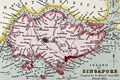 | Details | Fullarton, Archibald | 1870 |
| British Settlements Malay Peninsula Singapore Malacca Penang Labouan |
|
Fullarton, Archibald |
|
| 1870 |
| LOC:6 |
| $650.00 | Fullarton--Archibald | British-Settlements-Malay-Peninsula-Singapore-Malacca-Penang-Labouan | Scarce small map of British settlements, including Singapore, on the Malay Peninsula and on the coast of Borneo ca. 1870. By Archibald Fullarton. Engraved by J. Bartholomew, Edinburgh. Hand colored.
<br><br>
Five inset maps include:
<div class="indenttextblocksingle">
<ul style="list-style-type: circle;">
<li>Malacca and Nanning. Taken by the British 1795, restored to the Dutch 1801, again taken 1817, restored 1818, and resumed a third time by the British in 1825.</li>
<li>Sketch showing the positions of the British Settlements in the Malay Peninsula.</li>
<li>Island of Singapore. Occupied by the British since 1818.</li>
<li>Penang or Prince of Wales Island and Province Wellesley. Occupied by the British since 1786. Province Wellesley since 1802. Includes an inset of the city of George Town.</li>
<li>Island of Labouan [ Labuan ] Off the Coast of Borneo. Ceded to the British 1846.</li>
<li>Town and harbor of Singapore.</li>
</ul>
</div>
Depth soundings. Mountains shown by hachuring. |
| 6404 | 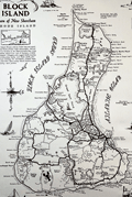 | Details | Overly, Charles H. | 1973 |
| Block Island Town of New Shoreham Rhode Island |
|
Overly, Charles H. |
|
| 1973 |
| LOC:87 |
| $185.00 | Overly--Charles-H- | Block-Island-Town-of-New-Shoreham-Rhode-Island | Very nice pictorial map of Block Island, Rhode Island lying in Block Island Sound. A better quality edition after Charles H. Overly's original map first printed in 1957. The map is printed on laid paper with a light brown tint throughout to simulate age. Scarce.
<br><br>
Esta Gray operated a gift shop in Old Harbor, Block Island- Esta's Gifts of Distinction. In 1957 Esta commissioned Charles H. Overly draw the map of Block Island to sell to tourists visiting her shop. This edition of the map is estimated circa 1973 after Charles Overly's map which contained a double decorative border and a 1957 copyright notice among other differences.
<br><br>
Charles H. Overly (1908-1970) was a University of Vermont graduate and artist. Returning home after a long tour of Europe, Overly began the Charles H. Overly Studio in 1938. He is best known for sketches and paintings of New England historical landmarks. |
| 6387 | 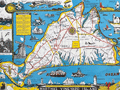 | Details | Parker, Larry | 1955 |
| Pictorial Map of Martha's Vineyard Island, Massachusetts |
|
Parker, Larry |
|
| 1955 |
| LOC:87 |
| $750.00 | Parker--Larry | Pictorial-Map-of-Martha-s-Vineyard-Island--Massachusetts | Original, scarce, 1950's Martha's Vineyard Island, Massachusetts pictorial map by Larry Parker. This lithographed tourist map features bright, bold colors, inset pictorial images of island life, and text blocks of historical facts, all hallmarks of a tourist souvenir map. Slight gloss to the paper finish as typical.
<br></br>
Remarkable condition.
<br></br>
This 1950's era edition is based on Parker's earlier 1935 black and white map of Martha's Vineyard Island. Not only does the new edition feature vivid lithographed color, several changes were made to the content including below the rope-wrapped bollard where the text "Edgartown Harbor" does not appear directly below the bollard. On this colored edition of Parker's map the area is blank. |
| 6388 | 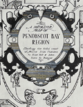 | Details | Phillips, Luther Savage | 1963 |
| Pictorial Map of Penobscot Bay Rare 2nd Edition |
|
Phillips, Luther Savage |
|
| 1963 |
| LOC:87 |
| $550.00 | Phillips--Luther-Savage | Pictorial-Map-of-Penobscot-Bay-Rare-2nd-Edition | Rare second edition of L. S. Phillips's (Luther Savage Phillips) 1940 first edition pictorial map of Penobscot Bay: "A Decorative Map of Penobscot Bay Region Showing the tidal coast of Maine from Camden to Blue Hill and Islesboro to Bangor."
<br><br>
This fine map is credited to Augustus D. Phillips, Luther's son, in 1963. Author attribution and dates are within, below left of the compass rose. Printed on quality laid paper.
<br><br>
No copies of A.D. Phillip's second edition are found online including WorldCat and AMPR. |
| 6382 |  | Details | VX9A | 1975 |
| Scarce map of Sable Island, Nova Scotia in the form of a QSL card. |
|
VX9A |
|
| 1975 |
| LOC:78 |
| $150.00 | VX9A | Scarce-map-of-Sable-Island--Nova-Scotia-in-the-form-of-a-QSL-card- | Scarce pictorial map of Sable Island, Nova Scotia, Canada as a QSL card. A QSL card is a written confirmation of two-way radiocommunication between two amateur radio stations, in this case between VX9A on Sable Island and W4UW on the 40 mhz (shortwave band) on November 2, 1975.
<br></br>
On card stock with one vertical and two horizontal folds, as issued. Verso with text and halftone images. |
| 6361 |  | Details | U.S. Coast and Geodetic Survey | 1914 |
| Key West Harbor 1914 |
|
U.S. Coast and Geodetic Survey |
|
| 1914 |
| LOC: |
| $1,000.00 | U-S--Coast-and-Geodetic-Survey | Key-West-Harbor-1914 | Large 42" x 34" U.S. Coast Survey chart of Key West Harbor, Florida . Issued September 1914 by the U.S. Department of Commerce / U.S. Coast Survey. Number 584. A scarce original nautical chart of Key West at 107 years old. Last date is 1914. |
| 6327 |  | Details | Trudeau, Garry B. | 2005 |
| Signed Key West poster by cartoonist Garry Trudeau |
|
Trudeau, Garry B. |
|
| 2005 |
| LOC:87 |
| $355.00 | Trudeau--Garry-B- | Signed-Key-West-poster-by-cartoonist-Garry-Trudeau | Rare limited edition poster by Doonesbury cartoonist Garry Trudeau (1948 - ) promoting the 23rd Annual Key West Literary Seminar, Humor: January 6 - 16, 2005. Number 58 of 100 issued. Signed and numbered by Trudeau.
<br></br>
In 1975 Garry Trudeau became the first comic strip artist to win a Pulitzer Prize, an honor usually awarded to editorial page cartoonists. |
| 5470 |  | Details | Prevost, Antoine-Francois | 1810 |
| Early map of Taiwan or Formosa after de Mailla 1721 1810 |
|
Prevost, Antoine-Francois |
|
| 1810 |
| LOC:6 |
| $600.00 | Prevost--Antoine-Francois | Early-map-of-Taiwan-or-Formosa-after-de-Mailla-1721-1810 | Early map of the island of Taiwan (Formosa / Formose) after a map from 1721 by Father de Mailla, a Jesuit priest. Father de Mailla's maps were published in volume 18 of <i>Lettres edifantes</i>, which dealt with the missions of the Jesuits on both hemispheres.
<br></br>
This copper-plate engraved antique map shows the extent of Chinese Imperial control over the western regions of Taiwan including the western coastlines of Taiwan and the adjacent Chinese mainland of Fujian province. Includes generalized, small-scale coverage of the Penghu Islands (the Pescadores) to the east of Taiwan in the Taiwan Strait. A more detailed look at the Penghu islands is available on another map after de Mailla in our inventory: <b>"Carte de Iles de Pong-hou …".</b>
<br></br>
Based on the volume and page collation numbers this antique map is believed to be from the Toulouse edition of <i>Lettres edifantes</i> printed in 1810. |
| 5471 |  | Details | Prevost, Antoine-Francois | 1810 |
| Early map Penghu Islands or Pescadores near Taiwan |
|
Prevost, Antoine-Francois |
|
| 1810 |
| LOC:6 |
| $250.00 | Prevost--Antoine-Francois | Early-map-Penghu-Islands-or-Pescadores-near-Taiwan | Scarce map of "Iles de Ponghou", the Penghu Islands (or Pescadores) in the Taiwan Strait off the east coast of Taiwan. After a map from 1721 by Father de Mailla, a Jesuit priest. Father de Mailla's maps were published in volume 18 of <i>Lettres edifantes</i>, which dealt with the missions of the Jesuits on both hemispheres.
<br></br>
Based on the volume and page collation numbers this antique map is believed to be from the Toulouse edition of <i>Lettres edifantes</i> printed in 1810.
<br></br>
Also, see de Mailla's early map of
<a href="https://www.rarecharts.com/ShowDetail/Creator/Prevost--Antoine-Francois/Title/Early-map-of-Taiwan-or-Formosa-after-de-Mailla-1721-1810/5470" target="_blank">the island of Taiwan</a> in our inventory. |
| 5467 |  | Details | Smyth, William Henry | 1827 |
| Complete 4-sheet set of Sardinia Capt W H Smyth |
|
Smyth, William Henry |
|
| 1827 |
| LOC: |
| $6,000.00 | Smyth--William-Henry | Complete-4-sheet-set-of-Sardinia-Capt-W-H-Smyth | Exceedingly rare and complete set of four nautical charts of the Mediterranean island of Sardinia by Captain William Henry Smyth based on his hydrographic survey of Sardinia for the Royal Navy during 1823 and 1824. Sardinia is the second largest island in the Mediterranean and one of 20 regions of Italy.
<br></br>
Whatman Turkey Mill watermark (date illegible) on one of four sheets. Complete set of four, ea. ~ 17" x 24".
Elson and Graves are co-authors for all four charts. Slater is credited on the chart of the entire Island.
<br></br>
In 1828 Smyth published a book on the political history of Sardinia- <b>"Sketch of the present state of the Island of Sardinia"</b> [1]. Smyth references a four chart set in the introduction to his "Sketch": <div class="indenttextblocksingle">… in conclusion it may not be unnecessary to state that my <strong>Nautical Survey of Sardinia</strong> has just been published, on four sheets, at the Hydrographical office of the Admiralty. As no pains have been spared in the construction, it is hoped that these charts will be found equal to every purpose of Navigation. [Smyth's chart titles are used here:] </br><div class="indenttextblocksingle">
<ul style="list-style-type: circle;">
<li>A general chart of the Island, "The Island of Sardinia"</li>
<li>"The South Coast of Sardinia"</li>
<li>"The North East Coast of Sardinia"</li>
<li>"The Gulf of Asinara on the N. W. Coast of Sardinia"</li></div>
</ul>
</div>
Small traces of manuscript pencil notations attesting to real-life use of this chart while at sea. Well-executed early to mid 20th-century conservation with the chart laid to linen and protected via a thin-film lamination process. After experience with the lamination process over time, lamination is not now considered to be a effective document conservation procedure.
<br></br>
[1] Captain William Henry Smyth. London. John-Murray. 351 pp.
<br></br>
[Sardegna] |
| 5047 | 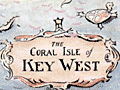 | Details | Dornbush, Adrian | 1935 |
| Depression era pictorial brochure 1st Edition map The Coral Isle of Key West |
|
Dornbush, Adrian |
|
| 1935 |
| LOC:500 |
| $300.00 | Dornbush--Adrian | Depression-era-pictorial-brochure-1st-Edition-map-The-Coral-Isle-of-Key-West | Two scarce maps of Key West, Florida in a visitor's guide booklet simply titled "Key West" published by the Key West Administration in 1935. The booklet is a product of the Public Works of Art Project (PWAP) during the New Deal that was succeeded by the Federal Art Project of the Works Progress Administration (WPA).
<div class="indenttextblocksingle">
"Public Works of Art Project artists from other parts of the country were brought in and put to work creating paintings, murals or public places, and other projects, such as tourist brochures and postcards." [1]
</div>
</br>
The brochure includes a fine 1st edition pictorial map (9" x 6") of Key West, Florida: "The Coral Isle of Key West" by artist Adrian Dornbush, 1935. The map (first edition) was engraved on a "miraculous" scale and shows key landmarks such as Duval Street, the lighthouse, the Martello Towers, and the yacht basin. Other FERA artists who contributed works to the brochure include Edward Bruce, Richard Sargeant, Avery Johnson, Klir Beck, and Richard Jansen.
<br></br>
At center of the brochure is an anonymous two-sheet "Map of the Lower Florida Keys or the Key West Archipelago" (18" x 6") containing a smaller inset map of the Caribbean region.
<br></br>
Printed by Orange Publishing Co. St. Cloud, Florida.
<br></br>
[1] https://keysarts.com/public_art/wpa.html <br>
[2] <a href="https://www.rarecharts.com/ShowDetail/Creator/Dornbush--Adrian/Title/Depression-era-pictorial-brochure-with-variant-2nd-Edition-map-Coral-Isle-of-Key-West/5493" target="_blank">See the second edition here.</a> |
| 5377 | 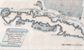 | Details | London Magazine | 1762 |
| Antique engraved Plan of the Straights of Bahama |
|
London Magazine |
|
| 1762 |
| LOC:13 |
| $325.00 | London-Magazine | Antique-engraved-Plan-of-the-Straights-of-Bahama | Original antique engraved map of the route taken by the British Fleet during their attack on the city of Havana, Cuba in 1762.
<br></br>
The map depicts the fleet's passage through the Old Bahamas Channel, a risky route just north of Cuba, through a channel only 10 miles wide at some points. The route taken by the British reduced the amount of warning time afforded to the Spanish Fleet.
<br></br>
Conducted during the Seven Years' War, the Siege of Havana was a successful British siege against Spanish-ruled Havana that lasted from March to August 1762.
<br></br>
"A Plan of the Straights of Bahama, through which the Expedition Fleet was Conducted in the Year 1762 against the Havana". Engraved for the London Magazine. Published from London by Baldwin in January 1763. |
| 5365 | 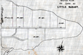 | Details | Anonymous | 1890 |
| Surveyors manuscript trace plat of Little Nahant Island, Massachusetts |
|
Anonymous |
|
| 1890 |
| LOC:13 |
| $750.00 | Anonymous | Surveyors-manuscript-trace-plat-of-Little-Nahant-Island--Massachusetts | Very rare unrecorded, manuscript surveyors' trace plat map of lots on Little Nahant Island, Massachusetts which lies north-east of Boston in Nahant Bay. The pen and ink trace, on supple surveyor's "tracing cloth" would have been used as a master to create blueprint copies.
<br></br>
Carries pencil surveyor's collation number 2013. Includes a fine late 19th century compass rose at bottom right. Estimated date ca. 1885.
<br></br>
Anonymous trace map but stylistically similar to those of W. H. Whitney from the 1890's. |
| 5329 | 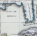 | Details | Cruttwell, Eliza Ann | 1824 |
| Fine antique manuscript map of West Indies Caribbean Florida |
|
Cruttwell, Eliza Ann |
|
| 1824 |
| LOC:11 |
| $435.00 | Cruttwell--Eliza-Ann | Fine-antique-manuscript-map-of-West-Indies-Caribbean-Florida | A very fine antique pen and ink manuscript map of the West Indies or Caribbean Sea stretching from Florida to South America. This beautiful one-of-a-kind map reflects extreme precision in execution with careful attention to fine detail and lettering. The map is original and 196 years old; it looks beautiful and fresh.
<br></br>
Shows and labels the provinces of West Florida and East Florida, on a Florida peninsula that has a squared-off form unlike other modern maps of the period and more like Mark Catesby's map of 1743. Includes the islands of Cuba, Santo Domingo, Porto Rico, Trinidad, Barbados, and many of the other usual suspects you would expect to see on a map of the West Indies.
<br></br>
This manuscript antique map of the West Indies, dated within to November 1824, is by signed by E. A. Cruttwell (probably Eliza Ann Cruttwell) (nee Wilson) the wife of Clement Wilson Cruttwell (1780-1816). Eliza Ann Cruttwell (1783-1858) was born in London, England.
<br></br>
Eliza Cruttwell's father-in-law, Rev. Clement Cruttwell (1743-1808) was a well known English publisher of maps and atlases. Clement Cruttwell is best known for his work "The New Universal Gazetteer ; or Geographical Dictionary … with twenty-eight whole sheet maps". London. Pub. G. Kearsley. 1798. That large gazetteer, in 3 volumes, was published in 19 editions. Clement Cruttwell's maps were published by G. G. & J. Robinson from London in 1799 in a separate atlas.
<br></br>
This map was part of a larger lot of manuscript maps by E. A. Cruttwell from the same atlas. |
| 5327 | 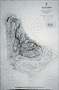 | Details | British Admiralty Hydrographical Office | 1917 |
| Admiralty sea chart of Barbados Bajan |
|
British Admiralty Hydrographical Office |
|
| 1917 |
| LOC:51 |
| $1,250.00 | British-Admiralty-Hydrographical-Office | Admiralty-sea-chart-of-Barbados-Bajan | Fine engraved antique nautical chart of the Island of Barbados first published by the British Admiralty in 1869 from a survey by Staff Commander J. Parsons, R.N. assisted by Navigating Lieut. H. R. Harris & G. Stanley R. N. This edition of the Barbados chart was published at the Admiralty on Feb. 26, 1873. This issue contains the latest corrections from 1917.
<br></br>
Two inset profile views of Barbados at bottom. Chart number 2485.
<br></br>
With two ink stamps for chart sellers from South America: Thomas Bruzzone e Hijos, Buenos Aires and Rodolfo Bosenberg, Libros y Mapas Maritimos [Buenos Aires]. |
| 5324 |  | Details | Anonymous | 1947 |
| Birdseye view of Johnston Island Atoll Pacific Ocean |
|
Anonymous |
|
| 1947 |
| LOC:300 |
| $295.00 | Anonymous | Birdseye-view-of-Johnston-Island-Atoll-Pacific-Ocean | One of a kind humorous birdseye view of the U. S. base at Johnston Island (also Johnston Atoll) in the Pacific Ocean. The author was clearly a member of the U. S. Armed Forces, probably Navy ("X.O.","yeomen", "chief"), who created this view as a memento or souvenir for others. Focus is one the off-hour entertainment and leisure activities on the island: Johnston Island Little Theater, Officer's Club, Ear Banger's Bar and Grill, J.I. Distillery, fishing, hobby shop, etc.
<br></br>
The date of this item is unclear but probably from the years immediately after WWII. Shows the troops engaged in construction activities. Quonset huts, four-engine propeller driven aircraft, and an airstrip apparently not paved and requiring watering to reduce the dust. No trace of heavy armament, or mention of the enemy, which would surely have been a major concern in the middle of the Pacific Ocean. The Navy operated Johnston Island from 1934 to 1948 when the Air Force took over. The site was used for high-altitude nuclear tests in the 1950s and 1960s.
<br></br>
Reproduced with a diazo process. |
| 5319 |  | Details | Dufour, Adolphe Hippolyte | 1850 |
| Antique Map of the Caribbean or Antilles |
|
Dufour, Adolphe Hippolyte |
|
| 1850 |
| LOC:11 |
| $255.00 | Dufour--Adolphe-Hippolyte | Antique-Map-of-the-Caribbean-or-Antilles | Fine engraved antique map of the Caribbean Islands from Florida to Venezuela. Map created by French cartographer A. H. Dufour ca. 1850.
<br></br>
Islands are colored according to the country who's possession each island was ceded to- England, Spain, France, Holland, Denmark, or Sweden. Legend or table at top center assigning colors to each occupying nation.
<br></br>
Engraved by Leclercq. Published by Mangeon. |
| 5306 |  | Details | Mannevillette, d'Apres | 1775 |
| Rare French charts of Vietnam Coast including Da Nang |
|
Mannevillette, d'Apres |
|
| 1775 |
| LOC:9 |
| $475.00 | Mannevillette--d-Apres | Rare-French-charts-of-Vietnam-Coast-including-Da-Nang | Two original antique engraved charts on a single sheet: the Con Son Island Archipelago and Da Nang Bay including the Vietnam coast between the towns of Hue and Da Nang: "Plan de l'Isle Condor"; "Carte d'une Partie de la Cote de Cochinchine".
<br></br>
Includes three fine inset coastal elevation views:
<div class="indenttextblocksingle">
<ul style="list-style-type: circle;">
<li>Vue de l'Isle Champello ou Cham Collao.</li>
<li>Vue de l'entrée de la Baye de Touranne (Da Nang was known as Tourane during the French colonial period)</li>
<li>Vue de l'Isle Condor lorsque la Havre...</li>
</ul>
</div>
From J. B. d'Apres de Mannevillette's sea atlas "Le Neptune Oriental ou routier general des Cotes des Indes orientales et de la Chine." Jean-Baptiste d'Après de Mannevillette (1707 - 1780) was a French sailor, navigator, and hydrographer active in the mid-18th century. Mannevillette studied mathematics and navigation in Paris before winning a commission as an officer on a merchant vessel headed for the West Indies. Mannevillette collected and revised a number of regional nautical charts during numerous voyages around Africa to India and China.
The Compagnie des Indes (French East India Company) appointed D'Apres de Mannevillette as director of maps and plans at Lorient in 1752. |
| 5297 |  | Details | Armstrong, Edward Robert | 1927 |
| Armstrong Seadrome map Floating airstrips Atlantic repeater station |
|
Armstrong, Edward Robert |
|
| 1927 |
| LOC:1405 |
| $750.00 | Armstrong--Edward-Robert | Armstrong-Seadrome-map-Floating-airstrips-Atlantic-repeater-station | Very rare cyanotype (blueprint) engineering diagrams from 1927 and a Seadrome route map related to Edward Robert Armstrong's Seadrome System, a proposed system of floating airports. Armstrong's Seadrome was the first major concept for a stable floating structure at sea. Its design influenced the later development of the semi-submersible drilling rig. [1]. Armstrong's Seadrome Map (center of sheet) shows locations of repeater structures and airports planned to be anchored in the Atlantic Ocean. Only available original map of the Seadrome concept signed by Armstrong.
<br></br>
In the late 1920's aircraft did not have the capacity to carry passengers non-stop across the Atlantic. Armstrong's Seadrome System was designed to anchor huge landing fields in the Atlantic Ocean at 375 mile intervals, enabling short-range aircraft to hop across the Atlantic.
<br></br>
Signed at bottom right corner "E.R. Armstrong 5/16/27."
<br></br>
This diagram shows Armstrong's Seadrome semi-submersible concept, modified and adapted for use as a repeater station for trans-Atlantic cable traffic. The repeater stations were conceived in order to increase the bandwidth of cables across the Atlantic, which in the late 1920's was limited to a single telephone conversation. Through the use of Armstrong's semi-submersible repeater stations and two cables Bell Telephone engineers calculated that eight circuits across the Atlantic Ocean might be achievable. In the end, the floating repeater station idea was scrapped as it was believed impractical. [2]
<br></br>
[1] Pease, F. T. The Armstrong Seadrome: World's First Semi-Submersible Design ??? The Society of Naval Architects and Marine Engineers. 13th Offshore Symposium, 24 February, Houston, Texas. January 21, 2004.
[2] Jacobs, O.B. Bell Laboratories Record. Vol XXXV. Number 6. June 1957. p. 207.
[3] https://sites.google.com/site/richardarthurnorton/edwardr.armstrong |
| 5283 | 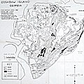 | Details | Torrey, Bill Sr. | 1956 |
| Rare privately published map of Ossabaw Island, Georgia |
|
Torrey, Bill Sr. |
|
| 1956 |
| LOC:10 |
| $750.00 | Torrey--Bill-Sr- | Rare-privately-published-map-of-Ossabaw-Island--Georgia | Rare, a privately-published first edition map of Ossabaw Island, Georgia from 1956 with roads, woods, ponds, marsh, and artesian wells as the chief focus. Contains an inset map showing the generalized coastline from Savannah to Brunswick, Georgia. Just behind the Egg Islands, at the north end of Ossabaw Island, Torrey's Landing is simply labeled "Boat House". Two additional maps on the verso.
<br></br>
The map was created and privately published by William F. "Bill" Torrey Sr., the son of Henry Torrey and Nell Ford Torrey who purchased the island in 1924. Bill Torrey Sr. ran a timber operation and a cattle business, Circle T. Ranch, on Ossabaw Island in the 1950's. The cattle business Torrey operated was no doubt the reason that the location of artesian wells on the island was considered as a key data point.
<br></br>
Together the three maps were designed for use by visitors to the island, providing route details from the DeSoto hotel in Savannah, GA to the Torrey Dock at Vernon View (verso); then from the dock to St. Catherine's Sound and Ossabaw Sound (verso). Once visitors had docked at Torrey Landing boat house the map (recto) served as a guide to the entire island. This map, by Torrey who knew the island well, is the reference source for place names and island locations on more recent maps. Source (DuBose, Elizabeth. Executive Director, Ossabaw Island Foundation. June, 2020. Personal communication.)
<br></br>
Ossabaw Island is Georgia's third largest barrier island, with 26,000 acres total - 9,000 acres of high ground. Ossabaw is bounded by the Atlantic Ocean to the east; the Bear River/ Florida Passage of the Intracoastal Waterway to the west; the Ogeechee River to the north; and, St. Catherine’s Sound to the south. |
| 5277 | 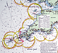 | Details | Stanford, Edward | 1900 |
| Superb late 19th-century nautical chart of the English Channel |
|
Stanford, Edward |
|
| 1900 |
| LOC:1409 |
| $2,575.00 | Stanford--Edward | Superb-late-19th-century-nautical-chart-of-the-English-Channel | A visually captivating and informative original antique 19th-century nautical reference chart of the English Channel with visible extent of lighthouses shown graphically. Uncommon. The few similar items that come to mind are Hardinge's 1874 "British Lighthouse Chart of General Coast Lights", and "A Chart Exhibiting the Light Houses and Light Vessels of the Coasts of Great Britain and Ireland" issued by the Corporation of the Trinity House, 1863.
<br><br>
This antique original, rolled, linen-backed chart, based on data from Lieutenant H.C. Lockyer in 1899, was published by Edward Stanford from Stanford's Geographical Establishment in London on March 1, 1900. Stanford's, established in 1853, remains in business today, now at 7 Mercer Walk in Covent Garden.
<br></br>
Coverage includes relevant portions of the coast of Ireland, Wales, England, and France, with Cornwall near chart center.
<br><br>
Scarce, especially in fine condition as this example. Only one institutional holding in WorldCat.
<br></br>
Contains drawings of the uniform system of buoyage: starboard-hand buoys, port-hand buoys, middle ground buoys; pillar, spar, and gas buoys; and wreck-marking vessels. Of great visual interest are the dozens of lighthouses identified on the chart with the range, frequency, duration, and color of each light provided for navigators. The chart is filled with tide tables, general information, soundings and distances and sailing directions for numerous ports. Topographical detail useful to navigators is shown for coastal locations and for those inland locations where the height of a feature warranted inclusion, e.g. Brecknock Mountain, Wales at 2862 ft. elevation.
<br></br> |
| 5243 |  | Details | Malham, John | 1797 |
| A Correct Chart of the West India Islands early Boston published |
|
Malham, John |
|
| 1797 |
| LOC:200 |
| $365.00 | Malham--John | A-Correct-Chart-of-the-West-India-Islands-early-Boston-published | Antique nautical chart showing the east coast of the United States south of Charlestown, South Carolina, the Gulf of Mexico, Cuba, Bahamas, Hispaniola, the West Indies, Central America, Columbia, and Venezuela south to the mouth of the Orinoco River. This chart has examples of interesting usage of terms that are today known only from history books: 'Spanish Main' for the southern Caribbean Sea; 'Terra Firma' denotes northern Colombia and Venezuela. Key noted cities include Charleston, Savannah, St. Augustine, New Orleans, Havana, Port Royal, Cartagena, Caracas.
<br></br>
From the rare first American edition of Malham's Naval Gazetteer, published by Spotswood and Nancrede in Boston in 1797. Early U.S. colonial nautical chart engravings are scarce.
<BR> </BR>
This chart comes from an early nautical gazetteer or geographical dictionary produced first in England and after 1796 in the United States by John Malham. Rev. John Malham was a prolific Yorkshire-born author who produced other diverse works that include "Navigation Made Easy and Familiar", "Twenty-Two Sermons on Doctrinal and Practical Subjects" and "The Scarcity of Wheat considered". Malham died near London in 1807. (Gentleman's Magazine, Vol 102, 1807, p. 568).<BR> </BR> |
| 5237 |  | Details | Bertius, Petrus | 1609 |
| Antique map of the East Indies or Moluccas |
|
Bertius, Petrus |
|
| 1609 |
| LOC:6 |
| $190.00 | Bertius--Petrus | Antique-map-of-the-East-Indies-or-Moluccas | Interesting original miniature antique map of the Maluku Archipelago or Moluccas near the Banda Sea ca. 1609 by Petrus Bertius. Includes Sulawesi, Timor, Seram and numerous other islands in the Malaku province of Indonesia. |
| 5210 |  | Details | Coronelli, Vincenzo | 1706 |
| Coronelli's Forte di Brigancon ed Isole de yeres (Bregancon, Hyeres) |
|
Coronelli, Vincenzo |
|
| 1706 |
| LOC:77 |
| $245.00 | Coronelli--Vincenzo | Coronelli-s-Forte-di-Brigancon-ed-Isole-de-yeres-(Bregancon--Hyeres) | Rare birdseye view of the island of Bregancon, France and the Isles de Hyeres by Coronelli. Today the island of Bregancon, near the French Riviera, is attached to the mainland by a short causeway. Includes the offshore islands of Tilan, Port Cros, Porquerolles and the village of San Margarita. Decorated with drawings of galleys under sail and oars.
<br></br>
This small well-engraved antique chart is from Coronelli's Teatro della Guerra. TEATRO DELLA GUERRA, DIVISO IN XXXXVIII. PARTI, IN CUI SONO ESATTAMENTE DELINEATI, E COMPENDIOSAMENTE DESCRITTI SIN L'ANNO M.DCC. NAPLES, 1706. (See also our smaller-scale chart of the entire Toulon harbor by Coronelli). Page 8.
<br></br>
Vincenzo Maria Coronelli (1650-1718), is considered as one of Italy's most famous and greatest cartographers and cosmographers to the Republic of Venice. |
| 5211 |  | Details | Coronelli, Vincenzo | 1706 |
| Rare antique chart of French islands of Sainte-Marguerite and Saint-Honorat |
|
Coronelli, Vincenzo |
|
| 1706 |
| LOC:77 |
| $265.00 | Coronelli--Vincenzo | Rare-antique-chart-of-French-islands-of--Sainte-Marguerite-and-Saint-Honorat | Rare chart of the a portion of the Cote d'Azur and islands of Sainte-Marguerite and Saint-Honorat off the coast of Cannes, (Canet) France near the Cap de Antibes.
<br></br>
This small well-engraved antique chart is from Coronelli's Teatro della Guerra. TEATRO DELLA GUERRA, DIVISO IN XXXXVIII. PARTI, IN CUI SONO ESATTAMENTE DELINEATI, E COMPENDIOSAMENTE DESCRITTI SIN L'ANNO M.DCC. NAPLES, 1706. Page 25.
<br></br>
Vincenzo Maria Coronelli (1650-1718), is considered as one of Italy's most famous and greatest cartographers and cosmographers to the Republic of Venice. |
| 5207 |  | Details | Mannevillette, d'Apres | 1775 |
| Nautical chart of the Nicobar Islands Indian Ocean |
|
Mannevillette, d'Apres |
|
| 1775 |
| LOC:9 |
| $300.00 | Mannevillette--d-Apres | Nautical-chart-of-the-Nicobar-Islands-Indian-Ocean | Original engraved sea chart of the Nicobar Island Archipelago in the Bay of Bengal. Islands in the Nicobar Archipelago include Car Nicobar, Battimalym, Chowra, Great Nicobar, Little Nicobar, Katchal, Nancowry, and more. In 2013 UNESCO declared 85% of Great Nicobar Island, the largest, as the Great Nicobar Biosphere Reserve.
<br></br>
Manvillette's chart Includes an inset plan of the channel between the islands of Camorta, Nancowry, and Trincut which would have provided a harbor from storms but where navigation without the chart would have been dangerous: "Plan Particulier du Port Compris entre les Isles Nancaueri, Souri, et Tricutte."
<br></br>
This fine hand-colored nautical chart is from J. B. d'Apres de Mannevillette's sea atlas "Le Neptune Oriental ou routier general des Cotes des Indes orientales et de la Chine." Jean-Baptiste d'Après de Mannevillette (1707 - 1780) was a French sailor, navigator, and hydrographer active in the mid-18th century. Mannevillette studied mathematics and navigation in Paris before winning a commission as an officer on a merchant vessel headed for the West Indies. Mannevillette collected and revised a number of regional nautical charts during numerous voyages around Africa to India and China. |
| 5197 | 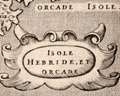 | Details | Porcacchi, Tomasso | 1572 |
| Isole Hebride et Orcade Scotland |
|
Porcacchi, Tomasso |
|
| 1572 |
| LOC:7 |
| $375.00 | Porcacchi--Tomasso | Isole-Hebride-et-Orcade-Scotland | Authentic copperplate-engraved antique map (1572) of the Hebrides and Orcades Islands off the mainland of Scotland. This map of the Orcades and Hebrides was drawn by Tomasso Porcacchi and was engraved by Girolamo Porro.
<br></br>
Printed in Tomasso Porcacchi's "Isolario" or island book "L'Isol Piu Famose Del Mondo". That work contains a number of finely engraved maps of islands and the continents at a reduced scale. Porcacchi (1530-1585) was born in Tuscany to a poor family and first settled in Florence. He wrote about history, geography, and archaeology and later published the Isolario from Venice, Italy in three editions beginning in 1572. |
| 5200 | 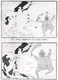 | Details | Army Bureau of Current Affairs | 1945 |
| Wartime pictorial maps one week after A-bombs on Japan |
|
Army Bureau of Current Affairs |
|
| 1945 |
| LOC:62 |
| $475.00 | Army-Bureau-of-Current-Affairs | Wartime-pictorial-maps-one-week-after-A-bombs-on-Japan | Large wartime pictorial poster issued less than one week after the United States used nuclear weapons on Hiroshima and Nagasaki, Japan. This issue, with a heavy emphasis on use of maps to communicate the progress of the war, was the first such to be issued by the [British] Army Bureau of Current Affairs (ABCA) after the United States dropped atomic bombs on Hiroshima and Nagasaki on August 6 and 9 respectively. The issue was published 3 days before Emperor Hirohito announced the total Japanese surrender on national radio.
<br></br>
The maps reflect the importance of the A-bomb to Allied war efforts and the hastiness with which this publication was revised before publication. No photographs or illustrations are present that show the mushroom cloud or the aftermath of the attacks. The verso contains text that does not reflect the news about the bomb: " … the counter invasion of this island empire [East Indies] has begun."
<br></br>
Printed on both sides:
<div class="indenttextblocksingle">
<ul style="list-style-type: circle;">
<li><b>Recto:</b> Headings include "The close of 14 years of Jap aggression" with six inset pictorial maps charting Japanese aggression from 1933 to 1945. Japan's early successes and later defeat are reflected in the image of a sword-bearing Japanese soldier who grows fat with success and then thin with defeat. Also, photographs of the British Cabinet and news from the Potsdam conference.</li>
<li><b>Verso:</b> "Riches of the Southern Seas". Large black and white pictorial map focused on the strategic value of key commodities in the Netherlands East Indies. Map contains pictograms for oil, rubber, rice, tin, and vegetable oils. </li>
</ul>
</div>
ABCA MAP Review No. 72 From July 30th to August 12th, 1945. Drawn and issued by the Army Bureau of Current Affairs. Printed for H.M. Stationery Office by Fosh & Cross Ltd., [1945]
<br></br>
No copies of this issue found online. Scarce. |
| 5186 | 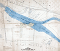 | Details | Oakland Waterfront Company | 1916 |
| Map of a Portion of Oakland Harbor and Alameda Encinal Basin |
|
Oakland Waterfront Company |
|
| 1916 |
| LOC:63 |
| $1,850.00 | Oakland-Waterfront-Company | Map-of-a-Portion-of-Oakland-Harbor-and-Alameda-Encinal-Basin | Large original map and engineering drawing of the area surrounding Alameda's present-day Star Harbor re-development project. The map, with <b>numerous manuscript notations</b>, shows a portion of Oakland Harbor related to the contract for dredging in the area of what is now the Marina Village Yacht Harbor in Alameda, California. Toward the bottom the map clearly shows a <b>"line segregating high-and-dry land from marsh land."</b>
<br></br>
<img src="/ZoomifyImages/SC_5186/SC_5186_Context.jpg" alt="Context map for the Oakland Harbor map of 1916" width="320" align="center" style="margin: 0px 20px">
<br></br>
</br>
This map was made in 1916 in the first decade after the City of Oakland took ownership of the waterfront (1907) after almost 50 years of private ownership by the Oakland Waterfront Company. The map shows Oakland Harbor from Webster Street with the Webster Street Bridge (1871-1928) and the Harrison Street Bridge (1898-1924) for the Southern Pacific Railroad; the western portion of Coast Guard Island, and those portions of Oakland and Alameda lying to the east just past Fortman Basin.
<br></br>
Oakland, California has a long history as an important transportation hub. Oakland was the western terminus for the Southern Pacific Railroad. Just east of the dredged area are the lands of the Alaska Packer's Association where, by 1925, the Encinal Basin was dredged for the use of cargo ships by what was to later become the Del Monte company.
<br></br>
Blueline base map with manuscript notations in red and green with hand-applied wash coloring. Dated within to 1916. Compiled by R.E. Demeritt, C.E.
<br></br>
Manuscript notations include engineering calculations and this statement: "
<b>"Duplicate of this map delivered to Harrison S. Robinson January 28, 1919. Geo Sessions."</b>
Harrison S. Robinson was an attorney in Oakland, California; George L. Sessions from Sessions Waterfront Company. |
| 5183 |  | Details | Herbinet, B. | 1895 |
| Manuscript map Iles Britanniques with submarine |
|
Herbinet, B. |
|
| 1895 |
| LOC:200 |
| $250.00 | Herbinet--B- | Manuscript-map-Iles-Britanniques-with-submarine | Interesting manuscript French map "Iles Britanniques" with vignettes illustrating the prowess of those isles at a time when Britain ruled the waves. Shows major roads or railways.
<br></br>
Inset vignettes include:
<div class="indenttextblocksingle">
<ul style="list-style-type: circle;">
<li>A suspension bridge</li>
<li>A coal mine</li>
<li><b>An early submarine: "la Gombe. Bateau sous marine"</b></li>
<li>A transitional three-masted warship with supplemental steam power </li>
<li>A geyser</li>
</ul>
</div>
Beautifully signed in manuscript "B. Herbinet Avril 1895" |
| 5185 |  | Details | British Admiralty Hydrographical Office | 1903 |
| Island of St. Lucia Port Castries |
|
British Admiralty Hydrographical Office |
|
| 1903 |
| LOC:51 |
| $575.00 | British-Admiralty-Hydrographical-Office | Island-of-St--Lucia-Port-Castries | Antique chart of Port Castries in the French West Indies. Castries is the capital and a major port on the island of St. Lucia in the Caribbean.
<br></br>
Published at the Admiralty on November 13, 1865. Chart number 499. |
| 5170 |  | Details | Porcacchi, Tomasso | 1572 |
| Antique map of Cyprus Cipro by Porcacchi |
|
Porcacchi, Tomasso |
|
| 1572 |
| LOC:2 |
| $375.00 | Porcacchi--Tomasso | Antique-map-of-Cyprus-Cipro-by-Porcacchi | Authentic copperplate-engraved antique map of the Mediterranean island of Cyprus (Cipro) by Tomasso Porcacchi.
<br></br>
Printed in Tomasso Porcacchi's "Isolario" or island book "L'Isol Piu Famose Del Mondo". That work contains a number of finely engraved maps of islands and the continents at a reduced scale. Porcacchi (1530-1585) was born in Tuscany to a poor family and first settled in Florence. He wrote about history, geography, and archaeology and later published the Isolario from Venice, Italy in three editions beginning in 1572. |
| 5161 | 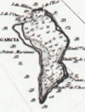 | Details | Depot de la Marine | 1870 |
| Antique French Chart of the Chagos Islands with Diego Garcia |
|
Depot de la Marine |
|
| 1870 |
| LOC:59 |
| $1,300.00 | Depot-de-la-Marine | Antique-French-Chart-of-the-Chagos-Islands-with-Diego-Garcia | Engraved antique nautical chart of the Chagos Island Archipelago, in the Indian Ocean, based on surveys of Moresby and Powell of the British East India Company. Published by the French Admiralty (Depot de la Marine) in 1841 with essential corrections in 1870.
<br></br>
The Chagos Island lie in the Indian Ocean about 300 miles south of the Maldive Islands. Diego Garcia, a United States military base, is located in the southeastern portion of the Chagos Archipelago.
<br></br>
Contains the circular anchor stamp of the Depot General de la Marine. With a black over-stamp, partially illegible but believed for "Cartes de la Marine Impériale. Debrie Libraire au Harve, Seul Depositaire."
<br></br>
Price: two Francs. Engraved by Chassant. Chart number 943. |
| 5162 | 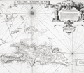 | Details | Frezier, Amedee | 1725 |
| Isle de S. Domingue |
|
Frezier, Amedee |
|
| 1725 |
| LOC:51 |
| $300.00 | Frezier--Amedee | Isle-de-S--Domingue | Map of the island of Hispaniola by Amedee Francois Frezier (1682-1773). Includes portions of the Bahamas, Cuba, Jamaica, and Puerto Rico. Decorative dedicatory cartouche.
<br><?br>
Includes an inset plan "Plan de la Ville Espagnole de S. Domingue". Condition issues at right margin but should mat and frame nicely. |
| 5158 |  | Details | British Admiralty Hydrographical Office | 1864 |
| Antique Chart of the Bay and Harbor at Trincomalee Trincomalie Ceylon Sri Lanka |
|
British Admiralty Hydrographical Office |
|
| 1864 |
| LOC:59 |
| $400.00 | British-Admiralty-Hydrographical-Office | Antique-Chart-of-the-Bay-and-Harbor-at-Trincomalee-Trincomalie-Ceylon-Sri-Lanka | Chart of the Bay and Harbor of Trincomalee, an important port in Sri Lanka, which has been called the finest in the Indian Ocean. Published by the Hydrographical Office of the British Admiralty on July 3rd, 1834. Last corrected 1864.
<br></br>
The numerous key features on the map include Flagstaff Point, Fort Frederick, Lake Tamblegam, Great Bay, Norway Point, Elephant Ridge, Round Island, and Great Saber Island. Numerous soundings and marked anchorages.
<br></br>
In 1834 the Nautical Magazine described the chart:
<div class="indenttextblocksingle">
"Double-elephant. Includes the whole of Back Bay on the north and Great Bay on the south with Foul Point. It gives a complete view of the whole of the indented coast by which the harbour of Trincomalee is surrounded."
</div>
(Vol. 3, p. 690)
<br></br>
The same issue noted a similar sized but larger scale chart only of the "Harbour of Trincomalee" by Owen, Cannon, and Loring. |
| 5154 | 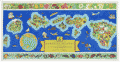 | Details | Edwards, Parker | 1937 |
| Dole Pictorial Map of the Hawaiian Islands 1937 |
|
Edwards, Parker |
|
| 1937 |
| LOC:63 |
| $1,100.00 | Edwards--Parker | Dole-Pictorial-Map-of-the-Hawaiian-Islands-1937 | Iconic pictorial map of the Hawaiian Islands drawn by Parker Edwards and published by the Hawaiian Pineapple Co., Ltd. In 1937. Includes the original, franked (4 cent) cardboard mailing tube. This extremely decorative 3-foot wide map is very desirable and somewhat scarce in this excellent A+ condition.
<br></br>
Top of the sheet contains a decorative border featuring a colorful assortment of local plant life. Lower border displays many of the bright, exotic fish that inhabit the waters around the islands of Hawaii.
<br></br>
Title:
<div class="indenttextblocksingle">
<ul style="list-style-type: circle;">
The Dole Map of the Hawaiian Islands U.S.A. being a Descriptive Portrayal of the History, Transportation, Industries and Geography of the Territory of Hawaii, U.S.A.
</ul>
</div> |
| 5152 | 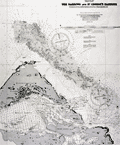 | Details | British Admiralty Hydrographical Office | 1918 |
| Chart of eastern Bermuda Islands St. Georges |
|
British Admiralty Hydrographical Office |
|
| 1918 |
| LOC:54 |
| $450.00 | British-Admiralty-Hydrographical-Office | Chart-of-eastern-Bermuda-Islands-St--Georges | Antique engraved British Admiralty chart of the eastern Bermuda Islands-- St. George's Island, Paget Island, Smith's Island, and St. David's Island. Shows roads and buildings then existing in St. George's Town and the channel dredged into St, George's Harbor in 1916 and 1917. Edition of February, 1918.
<br></br>
This navigational chart of Bermuda was published in July 1897, but 1918, under the superintendence of Rear Admiral W. J. L. Wharton. Engraved by Davies and Company. Sold by J.D. Potter, London.
<br></br>
Chart number 1315. |
| 5090 |  | Details | Diamond Match Company | 1942 |
| Galapagos Islands survey by U.S.S. Bowditch match book cover |
|
Diamond Match Company |
|
| 1942 |
| LOC:13 |
| $40.00 | Diamond-Match-Company | Galapagos-Islands-survey-by-U-S-S--Bowditch-match-book-cover | Scarce matchbook cover for the 386-foot U.S. Navy survey vessel U.S.S. Bowditch with an index map for their cruises of 1942-1943 to the Galapagos Islands, a part of Chile. Manufactured by the Diamond Match Company N.Y.C.
<br></br>
The USS Bowditch (AG 30) was first launched in 1929 at Copenhagen, Denmark, as the passenger ship Santa Inez. The Bowditch was outfitted as a surveying vessel and commissioned on 1 July 1940, with Commander E. E. Duval in command.
<br></br>
Departing Norfolk on 9 January 1942, the U.S.S. Bowditch steamed south to conduct surveys of the waters between Panama and Colombia, off the Galápagos Islands, and off the Cocos Islands in Costa Rica.
<br></br>
The following U.S. Navy charts were based on surveys conducted by the U.S.S. Bowditch in 1942 and 1943:
<div class="indenttextblocksingle">
<ul style="list-style-type: circle;">
<li># 5936 Approaches to Bahia Bartago, Archipielago de Colon (Galapagos Islands). 1942.</li>
<li># 5921 Eastern Approaches to Canal de San Salvador, Archipielago Colon (Galapagos Islands). 1943.</li>
<li># 5931 Western approaches to Canal Bolivar, Archipielago de Colon (Galapagos Island). 1942.</li>
<li># 5920 Isle Baltra, Archipielago de Colon (Galapagos Islands). 1942.</li>
<li># 5959: Golfo de Guyaquil. 1943.</li>
</ul>
</div>
The USS Bowditch was decommissioned in January, 1947 |
| 5079 |  | Details | British Admiralty Hydrographical Office | 1973 |
| Plans in the Islas Baleares from Spanish Government Charts |
|
British Admiralty Hydrographical Office |
|
| 1973 |
| LOC:58 |
| $175.00 | British-Admiralty-Hydrographical-Office | Plans-in-the-Islas-Baleares-from-Spanish-Government-Charts | Plans of the islands Ibiza and Formentera in Spain's Mediterranean Balearic Islands. Engraved in 1902 and published from London in July 8, 1902 by the British Admiralty under the superintendence of Captain W. J. L. Wharton, Hydrographer. Charts are after the Spanish Government Charts, 1898 - 1900. This sheet with corrections to 1973.
<br></br>
Includes the Balearic Islands of Ibiza and Formentera at a scale of 1 / 195,000 and the channel between Ibiza and Espalmador at a scale of 1 / 36,420
<br></br>
Chart number 3276. Crown Copyright Reserved. |
| 5077 |  | Details | British Admiralty Hydrographical Office | 1927 |
| Chart of Harbours and Anchorages in the Hawaiian or Sandwich Islands 1927 |
|
British Admiralty Hydrographical Office |
|
| 1927 |
| LOC:59 |
| $1,350.00 | British-Admiralty-Hydrographical-Office | Chart-of-Harbours-and-Anchorages-in-the-Hawaiian-or-Sandwich-Islands-1927 | Bold, engraved chart with harbor plans in the Hawaiian Islands first published by the British Admiralty in 1891 but 1927. Retains the distinctive appearance of antique British nautical charts. "Harbours and Anchorages in the Hawaiian or Sandwich Islands from Surveys of the Hawaiian Government". Engraved by Edward Weller. Excellent topographic detail for mountains and hills.
<br></br>
Apparently, quite scarce. No record of a sale in AMPR and only one copy in WorldCat.
<br></br>
Published at the Admiralty, London, February 5, 1891 under the superintendence of Captain W. J. L. Wharton, Hydrographer. This edition: 1912. Last correction in 1927. Sold by J.D. Potter.
<br></br>
Includes large-scale harbor and anchorage plans for 12 locations in Hawaii:
<div class="indenttextblocksingle">
<ul style="list-style-type: circle;">
<li>Waimea Bay, Kauai</li>
<li>Hanamaula Bay, Kauai</li>
<li>Kapueokahi Bay, Maui</li>
<li>Kaanapali Anchorage, Maui</li>
<li>Lahaina Roads, Maui</li>
<li>Pukoo Harbor, Molokai</li>
<li>Kaunakakai Harbor, Molokai</li>
<li>Kamalo Harbor, Molokai</li>
<li>Waimea Bay, Oahu</li>
<li>Waianae, Oahu</li>
<li>Waialua Bay, Oahu</li>
<li>Kawaihae Bay, Hawaii</li>
<li>Mahukona Harbor, Hawaii</li>
</ul>
</div> |
| 5067 |  | Details | British Admiralty Hydrographical Office | 1941 |
| Large chart of eastern Singapore Strait |
|
British Admiralty Hydrographical Office |
|
| 1941 |
| LOC:59 |
| $950.00 | British-Admiralty-Hydrographical-Office | Large-chart-of-eastern-Singapore-Strait | Large, used nautical chart for the eastern portion of Singapore Strait with eastern Singapore Island. Last corrections in 1941 were made shortly before the invasion of Singapore by Japan in February 1942.
Manuscript ink lines with notation: "Keep south of this line."
<br></br>
Published at the Admiralty October 1, 1927 under the superintendence of Rear Admiral H.P. Douglas, Hydrographer. Chart number 3834. Engraved 1927. Verso is blank with file drawer label. |
| 5064 |  | Details | Florida East Coast Hotels | 1908 |
| Scarce Hotel Sevilla, Havana Cuba Point of Sale Advertisement |
|
Florida East Coast Hotels |
|
| 1908 |
| LOC:400 |
| $325.00 | Florida-East-Coast-Hotels | Scarce-Hotel-Sevilla--Havana-Cuba-Point-of-Sale-Advertisement | Rare point-of-sale advertising placard for the opening of Hotel Sevilla in Havana, Cuba. 1908. With information and six pasted photographs for Hotel Sevilla. Two sides on hard stock with red edging. Verso with two large photographs for Hotel Champlain.
<br></br>
The Hotel Sevilla was scheduled to open on December 1st, 1908 under the management of A.E. Dick:
<div class="indenttextblocksingle">
"A new modern hotel with every convenience situated near the park and Prado, Expensively furnished throughout, delightfully comfortable, lofty ceilings, tiled floors, open courts, balconies, every room with a bath and other modern conveniences, electric lights, bells and telephones in every room."
</div> |
| 4979 |  | Details | Washington Map and Blueprint Company | 1895 |
| Cyanotype map of San Juan County, Washington state |
|
Washington Map and Blueprint Company |
|
| 1895 |
| LOC:88 |
| $475.00 | Washington-Map-and-Blueprint-Company | Cyanotype-map-of-San-Juan-County--Washington-state | Early blueprint (cyanotype) map of the San Juan Islands including Stuart Island, Waldron Island, Orcas Island, Shaw Island, Blakely Island, Lopez Island, San Juan Island and many more. Numerous water features include the Canal de Haro, San Juan Channel, President Channel, Rosario Strait, Strait of Juan de Fuca, and Thatcher Passage. Manuscript notations in red for several parcels of land on Orcas Island and Lopez Island.
<br></br>
Scarce. With detached fragmentary front cover of map. Price when issued 50 cents.
<br></br>
By the Washington Map and Blueprint Company, 607-11 Pacific Block, Seattle, Washington. That company was the successor to the O.P. Anderson Map and Blueprint Company, Engineers and Draughtsmen. Established 1885.
<br></br>
Printed by Lowman and Hanford Stationery and Printing Company. |
| 4940 |  | Details | Anonymous | 1809 |
| Manuscript chart of the island of Diego Garcia |
|
Anonymous |
|
| 1809 |
| LOC:200 |
| $975.00 | Anonymous | Manuscript-chart-of-the-island-of-Diego-Garcia | French manuscript chart of the island of Diego Garcia. Diego Garcia, a coral atoll, is the largest and southernmost member of the Chagos Archipelago, in the central Indian Ocean.
<br/><br/>
Dated on or near May 2, 1809 when the French Governor of Mauritius Decaen granted rights over the island to Cayeux, the Didier brothers, and Lapotaire. Lapotaire was reported to have over 100 slaves working his copra plantation in 1809. The map clearly shows those three land holdings, with Didier at the southern end of the island. (Cawley, Charles. Colonies in Conflict: The History of the British Overseas Territories. Cambridge Scholars Publishing. 2015.)
<br/></br/>
"Portuguese explorers discovered Diego Garcia in the early 1500s. The islands remained uninhabited until the 18th century when the French established coconut and copra plantations with the help of slave labor. Diego Garcia became a possession of the United Kingdom after the Napoleonic wars, and from 1814 to 1965, it was a dependency of Mauritius."
(Source: https://www.cs.mcgill.ca) |
| 4937 |  | Details | British Admiralty Hydrographical Office | 1925 |
| Awesome Chart of Vancouver Island Washington Territory |
|
British Admiralty Hydrographical Office |
|
| 1925 |
| LOC:65 |
| $875.00 | British-Admiralty-Hydrographical-Office | Awesome-Chart-of-Vancouver-Island-Washington-Territory | Very fine British Admiralty chart of Vancouver Island, the Strait of Juan de Fuca, San Juan Islands, the Washington Territory, Bellingham. An early 20th century copper-engraved chart with very fine detail. The topography and presentation are based on an earlier edition from the mid-19th century, with corrections as noted. With six fine inset elevation views of the coast.
<br/><br/>
"North America … West Coast … VANCOUVER ISLAND and Adjacent Shores of British Columbia Surveyed by Captain G.H. Richards, R.N." … First published by the Admiralty on Sept 25, 1865. Large corrections in 1890 and 1900 with last correction in 1925. Chart # 1917.
<br/><br/>
'Sir George Henry Richards (1820 –1896) was hydrographer to the British Admiralty from 1864 to 1874.
After joining the Royal Navy in 1832, Richards was a hydrographer on the coast of British Columbia in 1857–1862 and was the second British commissioner to the San Juan Islands Boundary Commission. Richards is responsible for the selection and designation of dozens of placenames along the British Columbia coast.
<br/><br/>
Richards conducted surveys in the Pacific Northwest aboard the survey ships Plumper, and later the Hecate. As second commissioner for the maritime boundary, he was tasked with a detailed survey of the waters between Vancouver Island and the American mainland, to help determine the location of the international boundary through the San Juan Islands. The survey was completed in June 1858.' (Dictionary of Canadian Biography. http://www.biographi.ca/en/bio.php?id_nbr=6394). |
| 4894 | 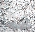 | Details | British Admiralty Hydrographical Office | 1918 |
| Antique Chart of Nantucket Sound and Eastern Approaches |
|
British Admiralty Hydrographical Office |
|
| 1918 |
| LOC:53 |
| $1,350.00 | British-Admiralty-Hydrographical-Office | Antique-Chart-of-Nantucket-Sound-and-Eastern-Approaches | Fine engraved British Admiralty navigation chart (1918) of Nantucket Island, Nantucket Sound and portions of "America" (what Nantucket locals seem to call the mainland U.S.A.). On Nantucket Island the chart shows some of the primary landmarks that guide visitors today: the Sankaty Head Light, Brant Point Lighthouse, Siasconset, Maddaket Harbor and more.
<br></br>
The chart, engraved by Edward Weller, is titled "United States East Coast. Nantucket Sound and Eastern Approaches. From United States Government Charts to 1914."
<br></br>
Notable locations shown on the mainland include Hyannis, Lewis Bay, Monomoy Island, Dennis Port, Harwich Port, and Chatham. Edition of February, 1916 with last corrections in 1918.
<br></br>
London. Published at the Admiralty, January 28, 1896 under the superintendence of Rear Admiral W.J.L. Wharton. C.B., F.R.S. Hydrographer. Sold by J.D. Potter. Chart number 2489. |
| 4868 | 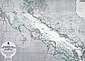 | Details | British Admiralty Hydrographical Office | 1957 |
| Chart Malacca Strait Pandang One Fathom Bank to Singapore. |
|
British Admiralty Hydrographical Office |
|
| 1957 |
| LOC:59 |
| $500.00 | British-Admiralty-Hydrographical-Office | Chart-Malacca-Strait-Pandang-One-Fathom-Bank-to-Singapore- | British Admiralty (United Kingdom Hydrographic Office) chart of the Strait of Malacca with portions of coastal Sumatra and Malaysia. Published May 21, 1954 but this sheet with corrections to 1957. Verso with a green ink stamp and the 1957 correction date by the seller: Iver C. Weilbach and Co. Copenhagen.
<br></br>
Singapore at bottom right. This presumed second state of the 1954 edition of 'Pandang and One Fathom Bank to Singapore' is distinguished by an expertly executed 2" x 3" pasted correction to coastal details at 103 degrees longitude in the vicinity of Senggarang. Includes the Johore Strait.
<br></br>
Scale 1/885,000. Chart number 1358. |
| 4861 | 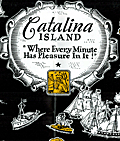 | Details | Edwards, Ham | 1929 |
| Antique Map Catalina Island, California Depression-era |
|
Edwards, Ham |
|
| 1929 |
| LOC:13 |
| $150.00 | Edwards--Ham | Antique-Map-Catalina-Island--California-Depression-era | Fine pre-depression-era brochure with a bright pictorial map of Catalina Island in the Pacific Ocean, off the coast of Long Beach, California. Published by Wilmington Transportation Company who offered steamer services from the Catalina Steamer Terminal to Catalina Island from Los Angeles, Long Beach, and Pasadena.
<br></br>
Included in a six-page brochure with things to do, rates for trips and ferry service, photographs, and advertisements for local hotels including the "Largest one floor hotel in the world with 1250 rooms." Map predates the Great Crash of October 1929 by three months.
<br></br>
Drawn by "Ham" Edwards - Art Services. |
| 4834 | 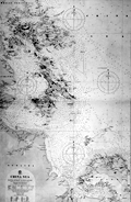 | Details | British Admiralty Hydrographical Office | 1912 |
| China Sea Banka Strait to Singapore |
|
British Admiralty Hydrographical Office |
|
| 1912 |
| LOC:59 |
| $1,500.00 | British-Admiralty-Hydrographical-Office | China-Sea-Banka-Strait-to-Singapore | Fine original British Admiralty Chart of the South China Sea with Singapore featured prominently at top left. Singapore, at the south end of the Malay peninsula, was made a British colony in 1946 and in 1965 became an independent republic. Singapore is separated from the Malay Peninsula to the north by the Johor Strait. At the time of last correction (1912) the chart showed only two navigational lights on the island of Singapore.
<br></br>
South of Singapore, across the Singapore Strait, lie the Riau Archipelago (Kepulauan Riau) including the islands of Batam, Bintan, Rempang, Galang, and numerous smaller islands.
<br></br>
A scarce and desirable chart.
<br></br>
Moving south down the East Coast of Sumatra past the islands of Batam, Bintan, Ligga, and Singkep, the chart ends at the Banka Strait and Banka Island.
<br></br>
Verso with manuscript index labeling in several locations. |
| 4832 | 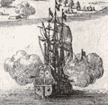 | Details | Limiers, Henri Philipp de | 1721 |
| Fine etched view of Kronstadt and St. Petersburg, Russia |
|
Limiers, Henri Philipp de |
|
| 1721 |
| LOC:13 |
| $265.00 | Limiers--Henri-Philipp-de | Fine-etched-view-of-Kronstadt-and-St--Petersburg--Russia | Early original engraved view of fortifications of Kronstadt (Cronstadt), Russia which Peter the Great founded on Kotlin (Retusari) Island in winter 1704 during the Great Northern War. Kotlin Island separates Neva Bay from the rest of the Gulf of Finland.
<br></br>
Despite the frigid conditions Imperial Russian forces quickly erected fortifications on the island:
<div class="indenttextblocksingle">
Under the command of Governor-general … Menshikov, workers used thousands of frames made of oak logs filled with stones which were carried by horses across the frozen sea, and placed in cuttings made in the ice. Thus, several new small islands were created, and forts were erected on them, virtually closing access to Saint-Petersburg by sea. Only two narrow navigable channels remained, with forts guarding them. (Online: https://en.wikipedia.org/wiki/Kronstadt).
</div>
<br/>
A few of the major features on this antique view of St. Petersburg may be identified by letter:
<div class="indenttextblocksingle">
<ul style="list-style-type: circle;">
<li>A- St. Petersburg, Russia</li>
<li>C - Kotlin Island (Retusari)</li>
<li>D- Kronstadt Fortifications</li>
</ul>
</div>
From "Histoire de Suede sous le Regne de Charles XII" by Limiers. Published from Amsterdam by Jansons & Waesberge. Tome 4. Page 188.
<br></br>
This view predates Bodenher's later, derivative print "Prospect von S. Petersgurg und der Insul Retusari" by 14 years. |
| 4830 | 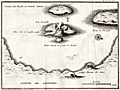 | Details | Ransonnette, Nicolas | 1783 |
| Scarce antique map of the Bay at Santorini, Italy |
|
Ransonnette, Nicolas |
|
| 1783 |
| LOC:13 |
| $175.00 | Ransonnette--Nicolas | Scarce-antique-map-of-the-Bay-at-Santorini--Italy | Interesting antique engraved map of the bay and islands of Santorini (Santorin), Italy. Shows the central portion of the volcanic caldera on "Isle Nouvelle" as emitting steam or smoke, an indication of recent and continuing volcanic activity on the island. Shows the Chateau de Searo. From "Illustrations de Lettres édifiantes et curieuses" by Nicolas Ransonnette (1745-1810). Tome 1, Page 78. |
| 4821 | 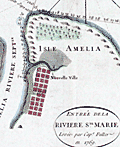 | Details | Jefferys, Thomas | 1770 |
| Rare Original Antique Chart of Amelia Island, Florida and Vicinity |
|
Jefferys, Thomas |
|
| 1770 |
| LOC:61 |
| $4,000.00 | Jefferys--Thomas | Rare-Original-Antique-Chart-of-Amelia-Island--Florida-and-Vicinity | Scarce engraved, hand-colored British navigation chart from 1770 containing three maps of Amelia Island, the Nassau River, Talbot Island and Cumberland Island, Georgia on the same sheet:
<div class="indenttextblocksingle">
<ul style="list-style-type: circle; ">
<li><b>Plan of Amelia Island in East Florida.</b> Based on an earlier survey by military engineer, surveyor, and cartographer John William Gerard de Brahm. De Brahm is known publishing “A Map of South Carolina and a Part of Georgia” in 1857.</b></li>
<li><b>A Chart of the Entrance to the St. Mary's River taken by Captn. W. Fuller.</b></li>
<li><b>A Chart of the Mouth of Nassau River and the Soundings on it taken at Low Water by Captn. W. Fuller.</b></li>
</ul>
</div>
Dedicated to John Earl of Egmont by William Fuller. Published by Thomas Jefferys, London, March 1770. |
| 4816 | 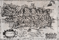 | Details | Mercator-Hondius | 1608 |
| Miniature version of Mercator's Iceland |
|
Mercator-Hondius |
|
| 1608 |
| LOC:77 |
| $350.00 | Mercator-Hondius | Miniature-version-of-Mercator-s-Iceland | Original antique map of Iceland from the French-text edition of Jodocus Hondius' Atlas Minor, published from Amsterdam.
<br></br>
Decorative title cartouche with title "Island" and a different title "Islandia" above. Page 27. French text on verso.
<br></br>
A fine smaller version of Mercator's earlier and larger map of Iceland based on the cartography of the Bishop of Hólar, Gudbrandur Thorláksson. Thorlaksson (1541-1627) is credited with producing the first somewhat accurate map of Iceland, published in 1590 by Abraham Ortelius in his Theatrum Orbis Terrarum.
<br></br>
A spouting sea creature is shown in the sea at upper right, while ashore Mount Hekla "Hekla Mons" is shown erupting with massive flames and boulders. Partly legible notation at Mount Hekla appears to read "perpetus" suggests the volcano erupted constantly at the time. |
| 4814 | 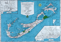 | Details | Bell, Euphemia Young | 1945 |
| Map of The Bermuda Islands alias Somers Islands |
|
Bell, Euphemia Young |
|
| 1945 |
| LOC:0 |
| $120.00 | Bell--Euphemia-Young | Map-of-The-Bermuda-Islands-alias-Somers-Islands | Colorful and very attractive map of Bermuda: "Map of The Bermuda Islands alias Somers Islands". The map was created by Euphemia Young Bell and published by 'Beautiful Bermuda' Publishing Co. as the front of a single-sheet brochure with numerous local Bermuda advertisements populating the verso. Publication of the book coincides with the end of World War II which marked the beginning of steady, sustained economic prosperity for Bermuda.
<br></br>
Folding map (8" x 6" folded) was copyrighted by Frank R. Bell in 1945 and sold with a cover as "The Standard Road and Railroad Map of the Beautiful Bermuda Islands." Inset maps of the City of Hamilton, and the Town of St. George. Large index of Places and Points of Interest including these categories:
<div class="indenttextblock">
<ul style="list-style-type: circle;">
<li>Airports</li>
<li>American Consulate General</li>
<li>Banks</li>
<li>Bicycle Garages</li>
<li>Churches</li>
<li>Ferry Landings</li>
<li>Golf Links</li>
<li>Government Offices</li>
<li>Guest Houses</li>
<li>Hospital</li>
<li>Hotels</li>
<li>Lodges and Clubs</li>
<li>Motor Fuel</li>
<li>Newspaper Offices</li>
<li>Public Utilities</li>
<li>Restaurants, etc.</li>
<li>Sightseeing</li>
<li>Theaters</li>
<li>Transportation Offices</li>
<li>Visitor's Information</li>
<li>Railway Stations</li>
</ul>
</div></div>
Lithographed by Hagstrom Company, Inc. N.Y. Map Makers. Seller's ink stamp on the cover. |
| 4811 |  | Details | Seutter, Albrecht Carl | 1730 |
| Fine antique map of Martinique in the Caribbean Sea |
|
Seutter, Albrecht Carl |
|
| 1730 |
| LOC:51 |
| $1,050.00 | Seutter--Albrecht-Carl | Fine-antique-map-of-Martinique-in-the-Caribbean-Sea | Beautiful original antique engraved map of the <b>Caribbean island of Martinique</b> ca. 1730. This is a map that has much to offer when viewed up close: wonderful topography with trees, mountains, roads, and rivers. Many important locations and structures are identified directly on the map, for example in the area around Fort de France Bay (Baye et Cul de Sac Royal): l'Hopital le Capucins, Morne Rouge, le Fort Royal St. Louis, le Cul de Sac a Vache, Notre Dame de Grace, and Café des Navires.
<br></br>
Discovered by Columbus in 1493, he landed there in 1502 and named the island Martinica. Martinique was a French colony from 1635-1946 when it became the French Overseas Department of Martinique.
<br></br>
Fine decorative cartouche with Mercury, god of Commerce, hovering above and Poseidon below while half-clothed Native Americans are shown trading with Europeans. Title reads: "Representation la plus nouvelle et exacte de l'Ile Martinique, la premiere des Iles del' Amerique Antilles nommees Barlovento, aux depens de Matthieu Seutter , graveur de cartes geograph de S.M.I. a Augsbourg."
<br></br>
Top of the map with an interesting Avertissement in French and German "Pour rendre cette Carte a l'usage des Navigateurs…des Marques" or an explantion of symbols used on the map that would be useful to navigators including water mills ("moulins a eau"), anchorages for small boats ("mouillage pour les petits batimens"), and sugar mills ("sucrerie"). Some of the more heavily traveled bays show depth soundings and below-water navigational hazards. |
| 4792 |  | Details | British Admiralty Hydrographical Office | 1899 |
| Antique British Chart of Gran Canaria island |
|
British Admiralty Hydrographical Office |
|
| 1899 |
| LOC:54 |
| $275.00 | British-Admiralty-Hydrographical-Office | Antique-British-Chart-of-Gran-Canaria-island | Antique, used 1899 British Admiralty nautical chart of the island of Gran Canaria one of the Canary Islands of Spain, lying off the coast of northwest Africa. In 1900 the population of the entire group of Canary Islands was estimated at almost 360,000 individuals with the main exports consisting of wine, spirits, potatoes, tobacco, bananas, and cochineal.
<br></br>
Based on a survey by Lieutenant William Arlett (d. 1839) of the Royal Navy aboard the ship Aetna. With several manuscript notations and course plots in pencil, attesting to a well-used life aboard ship. Arlett's notes on his survey of the Canary Islands describes his impression of the island and the survey method of triangulation, employed across the entire island :<div class="indenttextblock">
"On the 14th December we arrived at Port la Luz in the island of La Gran Canaria, the Great Canary. This island is nearly circular and about twenty-four miles in diameter, or seventy-five in circumference. Its is mountainous, and the coast, gereally speaking, precipitous. "
…<br></br>
"A base having been measured, a triangulation was carried completely round the island, whence the soundings as well as the coast line were laid down trigonometrically.
" (Arlett, W. The Journal of the Royal Geographic Society of London. Volume 6. 1836.)</div>
<BR/>
Highly detailed topography in the interior of the island. Includes these key features: Las Palmas, the capital city; la Luz Harbor; Ayrenaga Bay; Tenefe Point; Romeral Castle (Castillo); and Morro Colchas point with its lighthouse. With an inset plan of Maspalomas Anchorage and two inset coastal elevation views. Lighthouses are highlighted in yellow.
<br></br>
The chart was first published at the Admiralty in London on June 26th, 1848. Sold by J.D. Potter, agent for sale of Admiralty Charts, 14-5 Minories. Verso with MS chart collation number "5b". Number 1869. Numerous large and small corrections, the last correction in 1899. |
| 4771 |  | Details | U.S. Coast and Geodetic Survey | 1916 |
| Nantucket Sound Massachusetts |
|
U.S. Coast and Geodetic Survey |
|
| 1916 |
| LOC:53 |
| $1,200.00 | U-S--Coast-and-Geodetic-Survey | Nantucket-Sound-Massachusetts | Fine antique engraved nautical chart first issued in 1915 covers the southeast portion of Cape Cod trending south and includes Hyannis Harbor, Tuckernuck Island and the islands of Nantucket, Monomoy, Chatham and eastern Nantucket Sound.
<br></br>
This bright antique chart bears a stamp at the bottom right in black ink that identifies this edition as corrected to May 29, 1916. Plate number 3446 for this 1915 ed. replaced the previous edition of 1909 which used plate number 2999. With the circular logo of the Department of Commerce and Labor. Chart number 111. |
| 4769 |  | Details | Societa Partenopea di Navigazione | 1970 |
| Pictorial map of Amalfi Coast and Bay of Naples. |
|
Societa Partenopea di Navigazione |
|
| 1970 |
| LOC:0 |
| $35.00 | Societa-Partenopea-di-Navigazione | Pictorial-map-of-Amalfi-Coast-and-Bay-of-Naples- | Decorative pictorial map of the Bay of Naples and Amalfi Coast area in Italy ca. 1970. Includes the islands of Capri, Ischia, and Procida linked with mainland towns of Pozzuoli, Napoli, Sorrento, Positano, and Amalfi.
<br></br>
This colorful small map was published by the Italian transportation service SPAN, the Societa Partenopea di Navigazione. Art by Cassese. With the SPAN flag and the phrase "con la SPAN verso mete felici" or Google-translated from Italian as "with SPAN towards happy destinations."
<br></br>
Verso with a complete SPAN timetable in English. |
| 4770 | 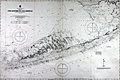 | Details | British Admiralty Hydrographical Office | 1920 |
| Large Antique Chart of The Florida Keys |
|
British Admiralty Hydrographical Office |
|
| 1920 |
| LOC:61 |
| $1,375.00 | British-Admiralty-Hydrographical-Office | Large-Antique-Chart-of-The-Florida-Keys | Fine antique British Admiralty sea chart with cartographic coverage of the islands of the <b>Florida Keys</b>. Hydrographic data on this early 1866 British navigational chart extend past Key West. Though updated to 1920, this scarce survivor retains the appearance of a 19th-century British copperplate-engraved nautical chart, a visual charm more recent charts do not generally possess.
<br></br>
An inset diagram shows an example <b>navigational beacon</b>, made of iron, 36 feet in height and carrying an identifying letter within a moveable vane. These beacons, or day marks, delineated the southern boundary of the Florida Keys. The accompanying note states:
<br></br>
<div class="indenttextblock">
<img src="/PageImages/Beacon for 4770.jpg" alt="Florida keys navigational beacons (day marks)" width="120" align="left" style="margin: 0px 20px">
"The Beacons marking the outer Florida Reefs are distinguished by Letter or Numbers in the vane which each carries, commencing off Key West and proceeding in alphabetical or numerical order toward Cape Florida. With the exceptions of that American Shoal which is brown and that on Fowey Rock which is black, the Beacons are all painted white. These beacons are likely to be washed away."
</div>
<br></br>Manuscript notations in pencil from a previous owner record eight of the beacons as "damaged."
<br></br>
This chart of Lower Matacumbe Cay to Boca Grande Cay should be treasured by anyone with interests in fishing, sailing, or boating in the Florida Keys.
<br></br>
After U.S. Coast Survey charts from the last half of the 19th century. First published by the British Admiralty on July 18, 1866, with several editions and later corrections after, the last correction in 1920. Originally sold by J.D. Potter, agents, London. Chart no. 1098. |
| 4750 | 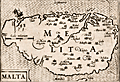 | Details | Bertius, Petrus | 1603 |
| 16th century map of Malta |
|
Bertius, Petrus |
|
| 1603 |
| LOC:77 |
| $380.00 | Bertius--Petrus | 16th-century-map-of-Malta | Attractive antique copper engraved map of the island of Malta (Melita), by Petrus Bertius. Contains a small vignette of St. Paul's shipwreck on the north of the island.
<br></br>
From "Tabularum Geographicarum Contractarum Libri Quinque", the finest and most important edition of the "Caert Thresoor", the famous miniature atlas of Barent Langenes, 1598.
<br></br>
The map is engraved by Petrus Koerius , or Pieter Van Den Keere (1571-1646). Amsterdam: Cornelium Nicolai; Latin edition of 1603. |
| 4730 | 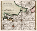 | Details | Renneville, René Augustin Constantin de | 1725 |
| Cote Meridionale de la Terre del Fuego |
|
Renneville, René Augustin Constantin de |
|
| 1725 |
| LOC:77 |
| $165.00 | Renneville--René-Augustin-Constantin-de | Cote-Meridionale-de-la-Terre-del-Fuego | Small antique chart of the southern Argentine portion of Tierra de Fuego, <b>Le Maire Strait</b> (about 18 miles in width), and Staten Island (Spanish: Isla de los Estados ). Key features include Mauritius Landt, Valentyns Bay, Isle de Diego Ramirez, Barneveldo Eylanden, and Withonds Bay. Tierra de Fuego is separated from the Argentine mainland by the Strait of Magellan.
<br></br>
From the French reissue of the account of early Dutch voyages first published in 1608 by Commelin: "Recueil des Voiages qui ont servi à l'établissement et aux progès de la Compagnie des Indes Orientales.
<br></br>
The French translation was by René Augustin Constantin de Renneville a 17th-century French author known for his works on the Inquisition, French Revolution, geography and religion. Recueil des Voyages was a multi-volume work about world voyages featuring full-page and folding engravings of landmarks, people, cultures as well as views and maps.
<br></br>
Amsterdam. Tome 9. Page 40. Dutch placenames and a French title.
<br></br>
In Richard Henry Dana Jr.'s book "Two Years Before the Mast" Staten Island is the first land seen from the ship after leaving San Diego. Dana describes the land as
<div class="indenttextblock">
". . . bare, broken, and girt with rocks and ice, with here and there, between rocks and broken hillocks, a little stunted vegetation of shrubs. . ."
</div>
A breeding colony of the Magellanic penguin is found in the Le Maire Strait on Isla de los Estados. |
| 4727 | 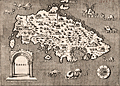 | Details | Porcacchi, Tomasso | 1572 |
| Very old antique map of Rhodes, Greece |
|
Porcacchi, Tomasso |
|
| 1572 |
| LOC:2 |
| $275.00 | Porcacchi--Tomasso | Very-old-antique-map-of-Rhodes--Greece | Authentic copperplate-engraved antique map (1572) of the Greek Dodecanese island of Rhodes (Rhodi) engraved by Girolamo Porro and drawn by Tomasso Porcacchi. Numerous fantastical sea serpents and monstrous fishes fill empty areas in the finely stippled seas. A few of the key features include smaller islands of Carchi, Limona, San Nicolo, and Tranquilla. Detail in the interior of Rhodes includes towns or villages of Villanova, Camira, Aganca, Zalfo, Sorini, Fiando, Rufarcangeli Farado, and more. The port of Rhodes or Rhodos is shown surrounded by fortified walls with several guard towers.
<br></br>
Printed in Tomasso Porcacchi's "Isolario" or island book "L'Isol Piu Famose Del Mondo". That work contains a number of finely engraved maps of islands and the continents at a reduced scale. Porcacchi (1530-1585) was born in Tuscany to a poor family and first settled in Florence. He wrote about history, geography, and archaeology and later published the Isolario from Venice, Italy in three editions beginning in 1572. |
| 4707 | 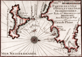 | Details | Michelot and Bremond | 1730 |
| Antique French nautical chart of Ibiza and Formentera, Balearic Islands, Spain |
|
Michelot and Bremond |
|
| 1730 |
| LOC:13 |
| $350.00 | Michelot-and-Bremond | Antique-French-nautical-chart-of-Ibiza-and-Formentera--Balearic-Islands--Spain | Attractive and authentic antique engraved nautical chart of the <b>Balearic islands of Ibiza and Formentera, Spain.</b> Includes the noted locations of St. Hilaire, Porto Magno, Cap Saline, Isle des Salines, and Isle Tagomago. The authors identify anchorages, navigation hazards, depth soundings, watering locations, and a shallow northern passage between the islands labeled "on peut passer ici par un beau tems." Shows the port and the town of Elvissa labeled "Yvice".
<BR> </BR>
This small antique chart is one of 37 port plans and harbor charts published by Henry Michelot and Laurens Bremond ca. 1730 in their small-scale atlas of Mediterranean ports: "Recueil de Plusieurs Plans de Ports et Rades de la Mer Mediterranée."
<BR> </BR>
Contains a carefully colored compass rose with north oriented to the right, |
| 4702 |  | Details | Bellin, Jacques Nicolas | 1750 |
| Antique plan of Diu Island, India |
|
Bellin, Jacques Nicolas |
|
| 1750 |
| LOC:13 |
| $155.00 | Bellin--Jacques-Nicolas | Antique-plan-of-Diu-Island--India | Antique plan of Diu Island and the Portuguese fortress at Diu, in Gujarat province, India. Includes St. Paul church, a mosque, and several defensive positions.
<br></br>
Shows the port and fortification of Diu once called the "Gibraltar of the East', with the hospital, the church of St. Paul and St. Jago. The fortification was the site of the Battle of Diu in 1509 between Portugal and a fleet of ships of the Ottoman, Egyptian, Venetian, allies of the Sultan of Gujarat, Mahmud Begada. Diu remained in possession of the Portuguese from 1535 until 1961, when it fell to troops of the Indian Union.
<br></br>
Re-engraved by von Schley after a French view by J.N. Bellin and published in Amsterdam in a Dutch edition of L'Histoire Generale des Voyages. Verso is blank. |
| 4696 |  | Details | Bertius, Petrus | 1616 |
| Descriptio Maioricae et Minoricae |
|
Bertius, Petrus |
|
| 1616 |
| LOC:13 |
| $350.00 | Bertius--Petrus | Descriptio-Maioricae-et-Minoricae | Colorful miniature antique map of the <b>Balearic Islands</b> (Baleares) of Majorca and Minorca, Spain in the Mediterranean Sea. This lovely copper-plate engraved map is from a Latin edition of Petrus Bertius' <b>Tabularum Geographicarum Contractarum</b>. The basis of the "Tabularum" was the atlas Caert Thresoor by Barent Langenes, first published in 1598. Key named features include Porto Pin, Calafigur, Calalonga, Menacor, Cabo Formentelli, Porto Fornelle, and San Catharina.
<br></br>
Sea monsters and a lateen-rigged sailing ship beautifully decorate the map while filling empty areas in the sea. In the crow's nest high above the deck a sailor is depicted throwing objects overboard, a detail perhaps related to a ritual of good fortune.
<br></br>
Latin text on verso. |
| 5196 |  | Details | Bertius, Petrus | 1616 |
| Majorcae Et Minorcae Descrip |
|
Bertius, Petrus |
|
| 1616 |
| LOC:77 |
| $325.00 | Bertius--Petrus | Majorcae-Et-Minorcae-Descrip | Uncolored miniature antique map of the <b>Balearic Islands</b> (Baleares) of Majorca and Minorca, Spain in the Mediterranean Sea. Key named features include Porto Pin, Calafigur, Calalonga, Menacor, Cabo Formentelli, Porto Fornelle, and San Catharina. Sea monsters and a lateen-rigged sailing ship beautifully decorate the map while filling empty areas in the sea. In the crow's nest high above the deck a sailor is depicted throwing objects overboard, a detail perhaps related to a ritual of good fortune.
<br></br>
This fine copper-plate engraved map of Mallorca from a <b>French edition</b> of Petrus Bertius' <b>Tabularum Geographicarum Contractarum</b>. The basis of the "Tabularum" was the atlas Caert Thresoor by Barent Langenes, first published in 1598.
<br></br>
French text on verso.
<br></br>
[ Mallorca, Majorca, Majorcae, Minorca, Menorca, Minorcae ] |
| 3691 |  | Details | Luffman, John | 1801 |
| Antique plan of the harbor at Rhodes, Greece for Luffman's Select Plans |
|
Luffman, John |
|
| 1801 |
| LOC:77 |
| $230.00 | Luffman--John | Antique-plan-of-the-harbor-at-Rhodes--Greece-for-Luffman-s-Select-Plans | Fine copper-plate engraved plan of the harbor at Rhodes, Greece, the largest of Greece's Dodecanese islands. Shows the two jetties at the harbor entrance each protected by two fortified positions. Along with the city walls, depth soundings and anchorages are clearly marked. Luffman notes: <div class="indenttextblock">
"The harbour of Rhodes is situated in the island of the same name in the Mediterranean Sea. Here stood the famous colossal statue of Apollo. The city is Lat 36.24 N Long 28.12 E of London."
</div>
</BR>
<br></br>
From "Luffman's Select Plans of the Principal Cities, Harbors, Forts etc. in the World". Engraved and published by John Luffman, No. 28 Little Bell Alley, Coleman Street. London. March 1, 1801. Volume II, Number 1.
<br></br>
Luffman also provided similar engravings to this at about the same time for J.T. Serres' "The Little Sea Torch: or, True Guide for Coasting Pilots." Serres translated the Little Sea Torch from an earlier illustrated coasting pilot guide, based on Bougard's "Le petit flambeau de la mer", first published in 1684.
<br></br>
John Luffman (1751-1821) began his career as an engraver, producing a very large and fine map of Antigua, where he had resided in 1787 and 1789. That map was published by Luffman to accompany his 'A Brief Account of the Island of Antigua', 1788." Luffman shared the same sad fate as many publishers and was declared bankrupt on 9th March, 1793. Moving forward Luffman was more cautious and produced small format atlases and handy-sized maps of the theatres of war, principal towns and cities and battle-plans relating to the Wars of the French directorate and the subsequent Napoleonic War. |
| 3666 |  | Details | Avery, Joseph | 1779 |
| Rare chart of the Channel Islands after Joseph Avery |
|
Avery, Joseph |
|
| 1779 |
| LOC:57 |
| $4,200.00 | Avery--Joseph | Rare-chart-of-the-Channel-Islands-after-Joseph-Avery | Unrecorded French chart of Îles de la Manche in the English Channel- the Normandy coast and Channel Islands after the survey of Joseph Avery. Islands include Alderney, Guernsey, Jersey, Herm, and Sark.
<br></br>
Though similar to Beaurain's chart of 1757, no copy of this very attractive work after Avery is found online nor in AMPR. No copy of Avery's own original survey is found anywhere but his work should be dated between 1721 and 1742.
<br></br>
Joseph Avery was born in Scotland and is known to have charted the southern coast of England ca. 1721 and to have published a "well approved" map of that work. Avery emigrated to Charleston, SC where he worked as a ship builder and was hired in 1742 as surveyor to the Georgia province. (Cadle, Farris W. Georgia Land Surveying History and Law. University of Georgia Press. 1991. Pages 4-26)
<br></br>
J.F.W. DeBarres chart of the Coast Rivers and Inlets of the Province of Georgia (1780) is credited to be after the work of Joseph Avery and others. |
| 3660 |  | Details | Mallet, Allain Manesson | 1719 |
| Neat antique view of Iceland |
|
Mallet, Allain Manesson |
|
| 1719 |
| LOC:77 |
| $175.00 | Mallet--Allain-Manesson | Neat-antique-view-of-Iceland | Manneson-Mallet's small and very interesting view of Hecla a volcano on Iceland, a Nordic island country in the North Atlantic Ocean. Hekla (Hecla) is a large and active volcano on the south of Iceland, part of a 40 mile long volcanic ridge. |
| 3652 |  | Details | British Admiralty Hydrographical Office | 1880 |
| Scarce British chart of the Falklands from Fitzroy, Robinson, and Sullivan |
|
British Admiralty Hydrographical Office |
|
| 1880 |
| LOC:51 |
| $4,000.00 | British-Admiralty-Hydrographical-Office | Scarce-British-chart-of-the-Falklands-from-Fitzroy--Robinson--and-Sullivan | Scarce, perhaps very rare, British hydrographic chart of the Falkland Islands based on observations taken during the surveys of Captain Robert Fitzroy (1805 -1865) and others. Includes ten coastal elevation views of the Falklands as seen from sea. Published by an act of Parliament in 1841 this chart was printed with corrections and additions in 1880. With the seller's oval blue ink stamp of Phillip, Son & Nephew, Agents for the Admiralty Charts, 49 South Castle Street, Liverpool.
<br></br>
No holdings of this chart are found in OCLC, no examples are online for sale. No records in AMPR.
<br></br>
Robert Fitzroy studied at the Royal Naval College. His first command was the famed sloop HMS Beagle. During the Beagle's second voyage (Dec. 1831 - Oct. 1836) Fitzroy surveyed the coasts of Patagonia, Tierra del Fuego and the Straits of Magellan, accompanied by the naturalist Charles Darwin, whose later publications were largely based on discoveries and observations made during this voyage. Darwin and Fitzroy shared quarters aboard the Beagle and their discussions aboard ship are believed to have greatly influenced Darwin.
<br></br>
The main purpose of the expedition was to conduct a hydrographic survey of the coasts of the southern part of South America. The voyages of the Beagle established FitzRoy as an excellent navigator, a sound surveyor and a man of science. Suffering from depression, Fitzroy took his own life with a straight razor in 1865. Today a settlement on East Falkland is named in honor of Robert Fitzroy.
<br></br>
Chart no. 1354. |
| 3653 | 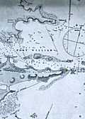 | Details | British Admiralty Hydrographical Office | 1875 |
| Scarce British chart of East Falkland Island and Stanley Harbor |
|
British Admiralty Hydrographical Office |
|
| 1875 |
| LOC:51 |
| $3,200.00 | British-Admiralty-Hydrographical-Office | Scarce-British-chart-of-East-Falkland-Island-and-Stanley-Harbor | Scarce, perhaps very rare, British hydrographic chart of the Stanley Harbor, Port William, and Port Harriett in the Falkland Islands. The chart is based on observations taken during the surveys of Captain Robert Fitzroy (1805 -1865) during the second voyage of the HMS Beagle. Includes an elevation view of the Cape Pembroke lighthouse.
<br></br>
A search of OCLC/WorldCat revealed that no libraries were found to hold the chart and no examples are online for sale. One instance of a sale of this chart is recorded in the Antique Map Price Record, in 2006.
<br></br>
Originally published by an act of Parliament in 1847. This chart was printed with corrections and additions in 1875 from London. With the seller's oval blue ink stamp of Phillip, Son & Nephew, Agents for the Admiralty Charts, 49 South Castle Street, Liverpool. Last correction 1875.
<br></br>
Robert Fitzroy studied at the Royal Naval College. His first command was the famed sloop HMS Beagle. During the Beagle's second voyage (Dec. 1831 - Oct. 1836) Fitzroy surveyed the coasts of Patagonia, Tierra del Fuego and the Straits of Magellan, accompanied by the naturalist Charles Darwin, whose later publications were largely based on discoveries and observations made during this voyage. Darwin and Fitzroy shared quarters aboard the Beagle and their discussions aboard ship are believed to have greatly influenced Darwin.
<br></br>
The main purpose of the expedition was to conduct a hydrographic survey of the coasts of the southern part of South America. The voyages of the Beagle established FitzRoy as an excellent navigator, a sound surveyor and a man of science. Suffering from depression, Fitzroy took his own life with a straight razor in 1865. Today a settlement on East Falkland is named in honor of Robert Fitzroy.
<br></br>
Chart no. 1774. |
| 3630 |  | Details | U.S. Coast and Geodetic Survey | 1888 |
| Early chart of St. John Harbor, Zarembo Island, Alaska |
|
U.S. Coast and Geodetic Survey |
|
| 1888 |
| LOC:10 |
| $300.00 | U-S--Coast-and-Geodetic-Survey | Early-chart-of-St--John-Harbor--Zarembo-Island--Alaska | Early chart of St. John Harbor on Zarembo Island in S.E. Alaska. Printed by the U.S. Coast and Geodetic Survey as a separately issued harbor chart for a price of 15 cents at the time.
<br></br>
Zarembo Island is an island in the Alexander Archipelago of southeastern Alaska, United States. It lies directly south of Mitkof Island and northwest of Etolin Island.
<br></br>
Rare to find old Coast Survey charts of this remote an area on such heavy paper. With red stamp of the U.S. Geological Survey library. Chart is believed to have been an institutional file copy. |
| 3602 |  | Details | Depot de la Marine | 1801 |
| Antique French sea chart of northern Cuba and the Bahamas |
|
Depot de la Marine |
|
| 1801 |
| LOC:51 |
| $700.00 | Depot-de-la-Marine | Antique-French-sea-chart-of-northern-Cuba-and-the-Bahamas | Authentic, old French nautical chart, an attractive antique engraving with hand coloring ca. 1801.
Inset plans include:
<div class="indenttextblock">"Plan du Mouillage que forment les Cayesde Piedra, Mono, Monillo et autres ajacentes."</div>
<div class="indenttextblock">"Plan du Mouillage que forment les Cayes Verde et Confites."
<br></br>
French antique navigation chart of the "Vieux Canal" or old canal of the Bahamas. Other features (in French) include Canal de Santarem and Banc de Los Rocques. Inset chart of the anchorage near Cayo Blanco ("les Cayes de Piedras, Monillo, et autres ajacentes") and of the anchorage at Cayo Verde and Cayo Confites. Circular logo of the Depot de la Marine.
<br></br>
"Carte Reduite d'Une Partie du Vieux Canal de Bahama st des Bancs Adjacents". Dated "l'An X" (10th year of the Revolutionary calendar). Published in Paris. |
| 2565 |  | Details | U.S. Coast and Geodetic Survey | 1855 |
| Preliminary Chart of Florida Reefs from Key Biscayne |
|
U.S. Coast and Geodetic Survey |
|
| 1855 |
| LOC:200 |
| $475.00 | U-S--Coast-and-Geodetic-Survey | Preliminary-Chart-of-Florida-Reefs-from-Key-Biscayne | Fine antique hydrographic survey chart of <b>Biscayne Bay</b>, Florida and surrounding area. Hundreds, perhaps thousands of depth soundings.
<br></br>
Miami, Florida is distinctly noted at the very top while a lighthouse is noted at the southern tip of Cape Florida. Other named features include: Old Rhodes Bank, Caesars Creek Bank, Elliott's Key, Triumph Reef, and Virginia Key.
<br></br>
Recommended reference for <b>treasure hunters</b>. Shows some locations of wrecks, dangerous reefs and banks.
<br></br>
Includes a list of abbreviations used to denote the sea floor composition (ex: S for Sand , C for clay).
<br></br>
A preliminary reduced-format hydrographic survey chart from a U.S. Coast Survey atlas with the U.S.C.G.S. circular winged logo. On thin paper with folds as issued. |
| 2562 | 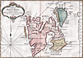 | Details | Bellin, Jacques Nicolas | 1758 |
| Antique French map of Spitsbergen, Norway |
|
Bellin, Jacques Nicolas |
|
| 1758 |
| LOC:88 |
| $270.00 | Bellin--Jacques-Nicolas | Antique-French-map-of-Spitsbergen--Norway | Fine 18th-century antique French map of Spits-berg (Spitsbergen), in today's Svalbard Islands - in northern Norway; the largest Norwegian island. One of the most northern regions to be discovered by Europeans, the place names seen here reflect the nationalities of those early travellers, English, Dutch, Scandinavian and French. Spitsbergen was first used as a whaling base in the 17th and 18th centuries.
<br></br>
The first known sighting of Spitsbergen by a European was by Willem Barentsz, who came across it in 1596 while searching for the Northern Sea Route.
<br></br>
Published in a French edition of L'Abbe Prevost's "Histoire Générale des Voyages", less than twenty years before Captain Cook's famous voyage. Page 192. Book 17. |
| 2518 |  | Details | Graves, Thomas | 1850 |
| Antique map of Cyprus from Thomas Graves |
|
Graves, Thomas |
|
| 1850 |
| LOC:4 |
| $280.00 | Graves--Thomas | Antique-map-of-Cyprus-from-Thomas-Graves | Steel engraved map of Cyprus based on a large chart produced after the survey by Admiral Thomas Graves in 1849.
<br></br>
From Longbeare and Howson. The Life and Epistles of St. Paul. London: Published by Longman & Co. |
| 1470 |  | Details | Depot de la Marine | 1801 |
| French antique chart of the Bahamas old channel and northern Cuba |
|
Depot de la Marine |
|
| 1801 |
| LOC:67 |
| $489.00 | Depot-de-la-Marine | French-antique-chart-of-the-Bahamas-old-channel-and-northern-Cuba | French antique navigation chart of the "Vieux Canal" or old canal of the Bahamas. Other features (in French) include Canal de Santarem and Banc de Los Rocques. Inset chart of the anchorage near Cayo Blanco ("les Cayes de Piedras, Monillo, et autres ajacentes") and of the anchorage at Cayo Verde and Cayo Confites. Circular logo of the Depot de la Marine. |
| 1460 |  | Details | Jefferys, Thomas | 1775 |
| Antique Chart of Guadeloupe in the Caribbean Sea Jefferys Sayer |
|
Jefferys, Thomas |
|
| 1775 |
| LOC:51 |
| $800.00 | Jefferys--Thomas | Antique-Chart-of-Guadeloupe-in-the-Caribbean-Sea-Jefferys-Sayer | Fine antique British chart of the island of Guadeloupe ("Guadaloupe") in the Caribbean Sea. Includes the nearby islets of Marie-Galante, Isle des Saintes, Petit Terre, and la Desirade. Jefferys names three main sections of Guadeloupe: Basse Terre, Cares Terre, and Grand Terre. With depth soundings, sand banks, and anchorages identified. Fine central compass rose.
<br></br>
Attribution reads: London. Printed for Robert Sayer Map and Printseller. No. 53 Fleet Street as the act directs 20 February, 1775.
<br></br>
The chart is from the scarce <b>first issue of The West-India Atlas, 1775 by Sayer</b>, the other issues being 1781, 1787, 1794, 1796, 1807, and 1818 published by Sayer and then Laurie and Whittle. The volume combined both the elements of an atlas and a pilot, with geographic and hydrographic information. The maps include those for the larger individual islands of the West Indies. <a href="https://www.davidrumsey.com/home" target="_blank">(Online).</a> |
| 1459 | 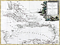 | Details | Zatta, Antonio | 1785 |
| French, English and Spanish Islands in the Caribbean Sea |
|
Zatta, Antonio |
|
| 1785 |
| LOC:10 |
| $425.00 | Zatta--Antonio | French--English-and-Spanish-Islands-in-the-Caribbean-Sea | Fine antique decorative map of the Caribbean Islands "Arcipelago delle Antille" with a beautiful and colorful title cartouche published from Venice, Italy. Shows Florida as an archipelago of islands. Antonio Zatta issued this attractive antique engraving in his "Atlante Novissimo" in 1785. |
| 1449 | 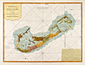 | Details | Lempriere, Clement | 1775 |
| Bermuda or Summer's Island West-India Atlas Lempriere Jefferys Sayer |
|
Lempriere, Clement |
|
| 1775 |
| LOC:51 |
| $4,500.00 | Lempriere--Clement | -Bermuda-or-Summer-s-Island-West-India-Atlas-Lempriere-Jefferys-Sayer | <div class="indenttextblock">
"This coast is the boldest in Bermuda and in some places the Largest Ships may with safety come within half gun shot of shore."
</BR></BR>
"Here in the months of March, April, and May they Fish for Whales."
</div>
</BR>
Above are a few of the notes from this fine antique chart of Bermuda. An extremely desirable British chart titled: "The Bermuda's or Summer's Islands." After a survey by Clement Lempriere. This is from the scarce <b>first issue of The West-India Atlas, 1775 by Sayer</b>, the other issues being 1781, 1787, 1794, 1796, 1807, and 1818 published by Sayer and later Laurie and Whittle.<a href="https://www.davidrumsey.com/home" target="_blank">(Online).</a>
<br></br>
On age-appropriate laid watermarked paper with a fleur-de-lis surmounted by a crown
<br></br>
During Bermuda's colonial period ca. 1615 the island was divided into eight equally-sized administrative areas west of St. George's called <b>"tribes" (parishes)</b>. These "tribes" were areas of land partitioned off to the principal investors of the Somers Isles Company.
<br></br>
From: "The West-India Atlas: or, A Compendious Description of the West-Indies: illustrated with Forty Correct Charts and Maps, taken from Actual Surveys. …"
Authors: Clement Lempriere (original survey), Thomas Jefferys.
Publishers: Robert Sayer.
Jefferys died in 1771; Sayer acquired Jefferys' materials in preparation for this atlas, and published the atlas posthumously under his name. |
| 1448 | 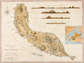 | Details | van Keulen, Gerard | 1775 |
| Curacao by Gerard van Keulen West-India Atlas Jefferys Sayer |
|
van Keulen, Gerard |
|
| 1775 |
| LOC:51 |
| $1,800.00 | van-Keulen--Gerard | Curacao-by-Gerard-van-Keulen-West-India-Atlas-Jefferys-Sayer | Fine, very desirable chart of Curaçao in the Lesser Antilles of the Caribbean Sea. Inset plan of Fort Amsterdam, in Willemstad, constructed in 1634 by the Dutch West India Company. A beautiful British published chart based on hydrographic surveys by Dutch cartographer Gerard van Keulen.
<br></br>
The chart is from the scarce <b>first issue of 1775 by Sayer</b>, the other issues being 1781, 1787, 1794, 1796, 1807, and 1818 published by Sayer and then Laurie and Whittle. <a href="https://www.davidrumsey.com/home" target="_blank">(Online).</a>
<br></br>
From: "The West-India Atlas: or, A Compendious Description of the West-Indies: illustrated with Forty Correct Charts and Maps, taken from Actual Surveys. Together with An Historical Account of the Several Countries and Islands which compose that part of the world. Their Discovery, Situation, Extent, Boundaries, Product, Trade, Inhabitants, Strength, Government, Religion, &c."
Authors: Gerard van Keulen, Thomas Jefferys.
Publishers: Robert Sayer.
Jefferys died in 1771; Sayer acquired Jefferys' materials in preparation for this atlas, and published the atlas posthumously under his name. |
| 1450 | 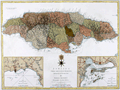 | Details | van Keulen, Gerard | 1775 |
| Jefferys Sayers Chart of Jamaica from West-India Atlas |
|
van Keulen, Gerard |
|
| 1775 |
| LOC:51 |
| $450.00 | van-Keulen--Gerard | Jefferys-Sayers-Chart-of-Jamaica-from-West-India-Atlas | Attractive, very desirable antique British chart of the Island of Jamaica in the Caribbean Sea by Thomas Jefferys. After surveys by Dutch cartographer Gerard Van Keulen.
<br></br>
This spectacular chart is from the scarce <b>first issue of The West-India Atlas, 1775 by Sayer</b>, the other issues being 1781, 1787, 1794, 1796, 1807, and 1818 published by Sayer and then Laurie and Whittle. <a href="https://www.davidrumsey.com/home" target="_blank">(Online).</a>
<br></br>
"The West-India Atlas: or, A Compendious Description of the West-Indies: illustrated with Forty Correct Charts and Maps, taken from Actual Surveys. Together with An Historical Account of the Several Countries and Islands which compose that part of the world. Their Discovery, Situation, Extent, Boundaries, Product, Trade, Inhabitants, Strength, Government, Religion, &c."
Authors: Gerard van Keulen, Thomas Jefferys.
Publishers: Robert Sayer.
Jefferys died in 1771; Sayer acquired Jefferys' materials in preparation for this atlas, and published the atlas posthumously under his name. |
| 1438 | 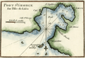 | Details | Roux, Joseph | 1780 |
| Roux antique plan of Vis (Lucca) harbor in Croatia |
|
Roux, Joseph |
|
| 1780 |
| LOC:2 |
| $125.00 | Roux--Joseph | Roux-antique-plan-of-Vis-(Lucca)-harbor-in-Croatia | Attractive, antique nautical chart / port plan of the town and harbor on the island of Vis, Croatia, ("Lissa") off the Dalmatian Coast, in the Adriatic Sea. Vis is furthest island in the Adriatic from the Croatian coast and lies southwest of the islands of Hvar, Brac and Solta.
<BR> </BR>
The port of Vis is identified by Roux as "Lucca". Other key features on this port plan include "Cut", "St. Spilice", "Calle St. George", "Calle Stance", and "Pointe Argentine". On the small and high offshore island of Otočić Host, Roux notes a "Reconnaissance pour le Mouillage" or a place to view the anchorage at Vis.
<BR> </BR>
For many years Vis was the military and naval headquarters of Tito’s partisan army and was closed to the public until 1989. This meant that it largely escaped commercial development and has been able to retain its natural beauty. Plate 85.
<BR> </BR>
Joseph Roux Sr. (1725-1793) was a French cartographer and hydrographer who lived in Marseille. The Roux family, with Roux's son Jospeh Jr. and grandson Antoine Roux, was involved in marine cartography and marine painting from Marseille into the mid-19th century. |
| 1439 | 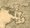 | Details | Popple, Henry | 1742 |
| Antique plan Fort-de-France Bay on Martinique, France Caribbean |
|
Popple, Henry |
|
| 1742 |
| LOC:41 |
| $85.00 | Popple--Henry | Antique-plan-Fort-de-France-Bay-on-Martinique--France-Caribbean | Antique chart fragment ca. 1742 of Baie de Fort-de-France or Fort-de-France Bay on the west side of the Island of Martinique, an overseas region of France. Includes Fort-de-France (Fort Royal). With soundings and sand banks delineated. Key locations named on the map include Flemish Bay, Grand and Petit Islets, Ramieres or Ramiers Ilet, and Cul de Sac au Hay.
<br></br>
This antique map was originally published by Covens and Mortier in 1742 in "Les Principales Forteresses Ports etc. de L'Amerique Septentrionale" a sheet containing harbor and island maps and plans of the Americas. This map is a fragment trimmed from the larger sheet.
<br></br>
That sheet of 18 maps and plans of islands and harbors was published by Covens and Mortier to replace Popple's original large map of 20 sheets with a more manageable six-sheet version. Popple's original map was titled: "A Map of the British Empire in America with the French, Spanish and the Dutch Settlements adjacent thereto". |
| 1416 | 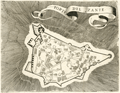 | Details | Coronelli, Vincenzo | 1686 |
| 17th century map of the Bohali fortress at Zakynthos, Greece |
|
Coronelli, Vincenzo |
|
| 1686 |
| LOC:2 |
| $160.00 | Coronelli--Vincenzo | 17th-century-map-of-the-Bohali-fortress-at-Zakynthos--Greece | Attractive 17th-century plan of the Venetian castle fortress on the island of Zakynthos or "Zante", Greece. Set atop a hill in the Bohali region of Zakynthos, the Bohali Castle is estimated to have been built in 1480 on the site of the ancient Acropolis. During the period of Venetian rule, the Castle was the capital of Zakynthos island, destroyed and repaired several times. In 1646 the walls were completed with help from the Venetians and their presence is apparent on the main outer gate where the wall bears the emblem of the famous Venetian 'Lion of St.Mark'.
<br></br>
Recent archaeological excavations at the Bohali Castle have found monuments from the Byzantine period, including a church dated to the 12th century.
<br></br>
This scarce wood-cut map was published by father Vincenzo Coronelli from Venice, Italy ca 1686 in "Memorie istoriografiche delli regni della Morea e Negroponte…".
<br></br>
Vincenzo Maria Coronelli (1650-1718) was an Italian Franciscan friar, cartographer, cosmographer and encyclopedist. Coronelli, a trained wood engraver, studied astronomy, Euclidean geometry and ancient philosophy and was named cosmographer for the Republic of Venice. He became most famous for his very large globes built in Paris from 1681-1683 at the order of King Louis XIV. His terrestrial and celestial globes measured 3.9 meters in diameter and were not equaled for more than 200 years. |
| 1396 | 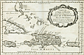 | Details | Bellin, Jacques Nicolas | 1754 |
| Caribbean Antique Map with Hispaniola (Hayti), Porto Rico, Jamaica |
|
Bellin, Jacques Nicolas |
|
| 1754 |
| LOC:0 |
| $285.00 | Bellin--Jacques-Nicolas | Caribbean-Antique-Map-with-Hispaniola-(Hayti)--Porto-Rico--Jamaica | Matted and framed.
<br></br>
Original mid 18th-century French map of Caribbean islands centered on the island of Hispaniola with Haiti and Santo Domingo by Nicolas Bellin. The island of Hayti ( Haiti ) is shown divided into the five pre-Columbian cacicazgos, or Taino kingdoms. Puerto Rico is named I. Boriquen or S. Jean Baptiste. Nearly all of Jamaica is shown, as well as the eastern half of Cuba, the Turks and Caicos islands, and the Bahamas as far north as Cat Island.
<br></br>
Size with frame 18" x 15".
<br></br>
Published in a French edition of L'Abbe Prevost's "Histoire Générale des Voyages". Tome 12, No. 1. |
| 1375 | 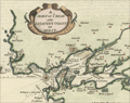 | Details | Moll, Herman | 1695 |
| Antique map of Belle Isle, Brest, in Brittany France |
|
Moll, Herman |
|
| 1695 |
| LOC:7 |
| $200.00 | Moll--Herman | Antique-map-of-Belle-Isle--Brest--in-Brittany-France |
Attractive antique copper-engraved map by Moll of the lower tip of Brittany (Bretagne), France from roughly the Pointe de Corsen, past Pointe de Kermorvan, le Conquet, Brest, and Crozon. This scarce map is titled "The Marquisate and Government of Bell-Isle Divided into its Four Parishes of the Palace, Bangor, Lomaria, and Sauzon."
<br></br>
One unusual feature of this map is the large number of mills the cartographer identifies, perhaps because their high elevation, like that of church steeples, would have provided coastal mariners with navigational reference points ashore. Together Moll's emphasis on features of great height and the rhumb lines with compass rose, suggest the original inspiration for this map is derived from a nautical chart. Verso with map of Belle Isle, France in the Sea of Bretagne. |
| 1359 |  | Details | Tassin, Christophe Nicholas | 1636 |
| Antique map of the Isle de Bouin, France |
|
Tassin, Christophe Nicholas |
|
| 1636 |
| LOC:0 |
| $80.00 | Tassin--Christophe-Nicholas | Antique-map-of-the-Isle-de-Bouin--France | Decorative antique island map of Bouin, France- an island, located in the Breton marshes that exists no more. Created by Nicolas Tassin in 1636, this neat small map shows what was the <b>Isle of Bouin</b> , a commune in the western Pays de la Loire region of France. At the time of our map Tassin shows almost every square foot covered with houses, roads, or ponds.
<br></br>
Archivally matted. With mat measures 12" W x 10" H.
<br></br>
The isle of Bouin no longer exists as such because over time the narrow channel separating the island from the mainland silted up, and the island became part of the mainland. The town of Bouin still exists.
<br></br>
Published in the small-sized atlas "Les Plans et profils de toutes les principales villes et lieux considerables de France" by Christophe Nicholas Tassin (d. 1660) . Tassin's background was as a military engineer, and he is best known for his nautical atlas of 30 sheets, dedicated to Richelieu, documenting France's coastline. Tassin's work contains topographic maps, often of militarily important sites, either sketched on site, composed from firsthand drawings by military engineers, or sometimes borrowed from other mapmakers. |
| 1356 |  | Details | Sanson, Nicolas | 1680 |
| Fine antique map of the Canary Islands and Madeira ca. 1680 |
|
Sanson, Nicolas |
|
| 1680 |
| LOC:7 |
| $325.00 | Sanson--Nicolas | Fine-antique-map-of-the-Canary-Islands-and-Madeira-ca--1680 | Very attractive early map of the <b>Canary Islands by Nicolas Sanson</b>. Inset map of Madeira ("Isle Madere"). This fine copper-plate engraved map is dominated by a large scroll-work title cartouche, which is decorated with an elaborate garland of fruit. Nice details of towns and geography for each island.
<br></br>
Nicolas Sanson (1600 – 1667) was a French cartographer, termed by some as the "father of French cartography". Nicholas Sanson was born in the town of Abbeville in Picardy. He became become Royal Geographer to Louis XIII in 1630 and maintained the position upon the ascension of the "Sun King" Louis XIV in 1643. Sanson later served as tutor to the ambitious young monarch. From 1648 Nicolas Sanson produced a series of four quarto atlases on the continents. That atlas of Africa was first published in 1656 and included this map.
<br></br>
The Canary Islands are a Spanish archipelago that lies off the coast of northwestern Africa. Sanson's names for the main Canary Islands and their modern equivalents are: "Isle de Palme" (La Palma), "Isle de Gomer" (La Gomera), "Isle Teneriffe" (Tenerife), "Isle Canarie" or "Grande Canarie" (Gran Canaria), "Isle de Forte" (Fuerteventura), and "Isle de Lancelotte" (Lazarote). |
| 1344 |  | Details | Luffman, John | 1802 |
| Behrings Strait and Alaska engraved for Luffman's Select Plans |
|
Luffman, John |
|
| 1802 |
| LOC:3 |
| $280.00 | Luffman--John | Behrings-Strait-and-Alaska-engraved-for-Luffman-s-Select-Plans | Scarce and attractive antique copper-plate engraved map of the Bering (Behring) Strait and Gulf of Alaska by John Luffman. This small but fine map extends past 70 degrees north latitude. The Bering Strait is a narrow body of water that links the Arctic Ocean with the Bering Sea and separates the continents of Asia and North America ( Alaska ) at their closest point. Some portions of the Alaska and Asia coasts not well explored at the time are shown with dotted lines, reflecting the uncertainty about their geography.
<br></br>
Key locations noted by Luffman include Bristol Bay, Cook River, Cape Prince of Wales, Cape Stephens, Cape Mulgrave, Cape Lisburn, Round Island, Norton Sound, and Trinity Island at the southern tip of the Kodiak Archipelago (not shown in its entirety).
<br></br>
Bering's strait averages 100 to 165 feet in depth and at its narrowest point is about 53 miles wide. About 20,000 years ago, during the Ice Age, the sea level fell by several hundred feet, making the strait into a land bridge between Asia and North America, over which the migration of plants and animals and humans occurred.
<br></br>
From "Luffman's Select Plans of the Principal Cities, Harbors, Forts etc. in the World". Engraved and published by John Luffman, No. 28 Little Bell Alley, Coleman Street, February, 1802. Volume II; Number 67.
<br></br> |
| 615 | 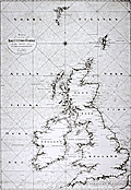 | Details | Klint, Gustaf | 1803 |
| Scarce Swedish chart of the British Isles by Admiral Gustaf Klint |
|
Klint, Gustaf |
|
| 1803 |
| LOC:0 |
| $1,500.00 | Klint--Gustaf | Scarce-Swedish-chart-of-the-British-Isles-by-Admiral-Gustaf-Klint | Original antique nautical chart of the British Isles from 1803 by Admiral Gustaf Klint (1771 - 1840) of the Swedish Royal Navy. This scarce antique "Karta ofver Brittiske Öarne" covers the Shetland, Faroe, and Orkney Islands, England, Scotland, Wales, and Ireland to Cornwall and the western coast of France below Calais. The engraving on this chart is quite exceptional and with added color could be a startling conversation piece. <br></br>
Charts of the British Isles by Admiral Klint are scarce as most of his hydrographic efforts were spent on his native land, Sweden- principally the Gulf of Bothnia. Klint is also known for his sailing directions of the Baltic Sea, Gulf of Finland, and Gulf of Bothnia, published posthumously. Number 19. <sup>1</sup>
Swedish text.<br></br>
<sup>1</sup> Dawson, L.S. ( Commander ). "Memoirs of Hydrography including brief biographies of the Principal Officers who have served in H.M. Naval Surveying Services between the years 1750 and 1885". Part II. 1885. [ http://books.google.com/books?id=3SwBAAAAQAAJ&dq=gustaf+klint+admiral&source=gbs_navlinks_s ] |
| 1338 |  | Details | British Admiralty Hydrographical Office | 1926 |
| Chart of Lower Baja California, Cabo San Lucas, to Manzanilla Bay |
|
British Admiralty Hydrographical Office |
|
| 1926 |
| LOC:0 |
| $525.00 | British-Admiralty-Hydrographical-Office | Chart-of-Lower-Baja-California--Cabo-San-Lucas--to-Manzanilla-Bay | Amazing, clean, authentic British nautical chart of lower Baja Peninsula and west coastal Mexico with Sinaloa, Jalisco and the Sea of Cortez. Heading southward this popular and highly attractive chart covers from San Ignaciao Bay to Manzanillo Bay. This large chart will make a very attractive, unusual, and affordable gift for anyone with an interest in fishing or boating in the vicinity of Baja California. Thousands of depth soundings and numerous well-known fishing spots are noted including: San Jaime Bank, Golden Gate Bank, Outer Gorda Bank, Finger Bank, and Morgan Bank. Two inset profile views at top of the Baja Californa coast as seen from offshore near Las Animas.
<br></br>
Later edition of a British Admiralty chart first engraved and published from London in 1879; this edition to 1916 and the last corrections made in 1926. Coverage includes the lower Baja California Peninsula and Gulf of California (Sea of Cortez) from Las Animas to Cabo San Lucas, Mexico, Mazatlan, Cape Corrientes, and on to Manzanillo Bay. Contains detailed names of the numerous rivers, lights, capes, and bays surrounding the Baja Peninsula. Includes the Revillagigedo Archipelago.
<br></br>
Bold dark lithographed print retains the cartographic look and style of the late 19th century. More recent charts do not display the character of this beauty. Logo of the British Hydrographical Office at top of the title block. Originally published from London on April 9, 1879 but the edition of 1916 with corrections to 1926. Number 2323. |
| 1295 |  | Details | Bellin, Jacques Nicolas | 1753 |
| Antique South Pacific map with oddly-shaped Australia |
|
Bellin, Jacques Nicolas |
|
| 1753 |
| LOC:6 |
| $600.00 | Bellin--Jacques-Nicolas | Antique-South-Pacific-map-with-oddly-shaped-Australia | Fine 18th-century antique French map of the South Pacific showing recent discoveries as of mid century: Australia's posited eastern coastline is virtually featureless, running from New Guinea to Tasmania without a break. Only a small section of the western coast New Zealand is marked, the rest unknown. The Americas are shown from Baja California through Central America and the western coastline of South America including the Straits of Magellan and Cape Horn.
<br></br>
Published in a French edition of L'Abbe Prevost's "Histoire Générale des Voyages", less than twenty years before Captain Cook's famous voyage. |
| 1292 |  | Details | Doncker, Hendrick | 1664 |
| Antique nautical chart of Norway, Spitsbergen, Greenland, and Russia |
|
Doncker, Hendrick |
|
| 1664 |
| LOC:200 |
| $1,500.00 | Doncker--Hendrick | Antique-nautical-chart-of-Norway--Spitsbergen--Greenland--and-Russia | Scarce copper-engraved sea chart of Spitsbergen, Norway and to the west, the largely unknown shores of Greenland. by cartographer Hedrick Doncker, Amsterdam. Coverage on this very attractive antique sea chart includes "Finnmarken" (Norway), "Lapland", "Nieu Groenlandt", Jan Mayen Island, Svalbard ("Spitsbergen"), "Nova Zemla", and Russia with Arkhangelsk ("Archangel"). Shows a longer coastline for Greenland than later editions of the same map by Doncker. Dated within to 1664.
<br></br>
Hendrick Doncker (1626-1699) was an Amsterdam printer, bookseller, and cartographer residing in the Nieuwe Bruchsteegh in Stuurmans Gereetschap. |
| 1288 | 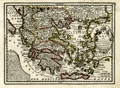 | Details | Chiquet, Jacques | 1719 |
| Old antique map of The Greek Archipelago |
|
Chiquet, Jacques |
|
| 1719 |
| LOC:2 |
| $210.00 | Chiquet--Jacques | Old-antique-map-of-The-Greek-Archipelago | Decorative map of Greece and Turkey displaying the wide extent of the Aegean Archipelago. Fine engraving and a title cartouche flanked by two winged female figures, topped by a fan shaped shell. Dated within at 1719. This attractive antique map, now nearly 300 years old, is characterized by its strong impression, evident platemark, and restrained hand coloring.
<br></br>
Named features include: Negroponte, Athens, the Peloponnese, Zante, Corfu, Macedonia, Constantinople,
Naxos, Santorini, Crete, and Rhodes.
<br></br>
From "Le Nouveau et Curieux Atlas Geographique et Historique..." by Jacques Chiquet. |
| 1287 | 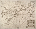 | Details | Collins, Greenvile | 1750 |
| Antique Chart of the Shetland Islands |
|
Collins, Greenvile |
|
| 1750 |
| LOC:0 |
| $156.00 | Collins--Greenvile | Antique-Chart-of-the-Shetland-Islands | Antique sea chart of the eastern portion of the <b>Shetland island of the "Mainland"</b>, a part of Scotland. Includes the islands of Bressay (Brassey) and Noss (Nos). Noted are the villages of Lerwick, Heoghan, Laxford and many more.
<br></br>
Decorative antique eighteenth century copperplate nautical sea chart, printed on thick paper ca. 1750. Attribution for engraving at bottom left to "H. Moll"- Herman Moll.
<br></br>
From Captain Greenville or Greenvile Collins "Great Britain's Coasting Pilot: being a new and exact survey of the sea-coast of England and Scotland from the river of Thames to the westward and northward ...".
<br></br>
Greenville Collins was an officer of the Royal Navy and prominent hydrographer who was commissioned by King Charles II in 1676 and appointed by Samuel Pepys to chart the coasts of Great Britain. The resulting atlas - Great Britain's Coasting Pilot - was the first original sea atlas to be produced by an Englishman. |
| 1316 | 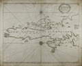 | Details | Collins, Greenvile | 1750 |
| Antique Chart of the South Shetland Islands |
|
Collins, Greenvile |
|
| 1750 |
| LOC:0 |
| $240.00 | Collins--Greenvile | Antique-Chart-of-the-South-Shetland-Islands | Old engraved antique sea chart of the southern portion of the <b>Shetland Islands</b>, a part of Scotland. Includes the islands of Tronzo, Nebra, West Buro, Bressay (Brassey) and Noss (Nos). Inset chart of Catford Roe with soundings and anchorages noted.
<br></br>
A decorative antique eighteenth century copperplate nautical sea chart, with an authentic sea-worn appearance, printed on thick paper ca. 1750.
<br></br>
From Captain Greenville or Greenvile Collins "Great Britain's Coasting Pilot: being a new and exact survey of the sea-coast of England and Scotland from the river of Thames to the westward and northward ...".
<br></br>
Greenville Collins was an officer of the Royal Navy and prominent hydrographer who was commissioned by King Charles II in 1676 and appointed by Samuel Pepys to chart the coasts of Great Britain. The resulting atlas - Great Britain's Coasting Pilot - was the first original sea atlas to be produced by an Englishman. |
| 1286 | 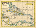 | Details | Tryer, James | 1822 |
| Antique map of the Caribbean Sea and the Spanish Main |
|
Tryer, James |
|
| 1822 |
| LOC:5 |
| $195.00 | Tryer--James | Antique-map-of-the-Caribbean-Sea-and-the-Spanish-Main | Antique map of the West Indies at the beginning of the 19th century by James Tryer. The area covered stretches from Florida in the north the Gulf of Darien in the south and from the Yucatan peninsula in the west to the Orinoco river in the east. Includes portions of the Atlantic Ocean, Gulf of Mexico, Caribbean Sea, Pacific Ocean, and Sea of Honduras. The northern coast of South America is labeled "The Spanish Main".
<br></br>
James Tyrer was a prolific engraver from Pentonville, London who flourished during the early part of the nineteenth century. This neat map was published by John Souter in Clark's A New General School Atlas in 1822. |
| 1278 | 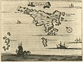 | Details | Dapper, Olfert (Olivier) | 1703 |
| De l'Ile de Scyros (Skyros) |
|
Dapper, Olfert (Olivier) |
|
| 1703 |
| LOC:0 |
| $115.00 | Dapper--Olfert-(Olivier) | De-l-Ile-de-Scyros-(Skyros) | Antique copper-plate engraved map of the <b>Greek Island of Skryos</b> (also Skiros or Scyros) by Olfert Dapper. Skyros is the southernmost island in the <b>Sporades Archipelago</b>. Dapper notes by name two smaller nearby islands, Schirodola (Skiropoula), and Skantzoura (Scanda) and off the east coast Dapper identifies 4 anchorages maked with "A" and notes: "Tutti Buoni Porti".
<br></br>
Decoratively presented with a ribbon title block and depictions of a square-rigged man-of-war and two galleys with lateen sails. North is oriented at the top left corner.
<br></br>
From "Description exacte des isles de l'archipel, et de quelques autres adjacentes…" by Olfert Dapper. This leaf with French text from 1703 was originally published in Dutch in 1688. |
| 1276 | 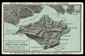 | Details | Philip. George | 1880 |
| Antique trade card for publishers George Philip and Son, London |
|
Philip. George |
|
| 1880 |
| LOC:0 |
| $165.00 | Philip--George | Antique-trade-card-for-publishers-George-Philip-and-Son--London | Large 19th-century <b>trade card</b> ca. 1880 for <b>George Philip & Son Ltd.</b>, London, England, one of the oldest publishers in the United Kingdom. This trade card promotes Philips' map design capability and printing technology: "MAPS SPECIALLY PREPARED FOR ALL PURPOSES" and "For Ideal Advertising. Philips' Map Schemes always attractive, useful, and profitable. Colour printing by modern methods."
<br></br>
The two-color card image shows the Isle of Wight with the Solent and Spithead.
<br></br>
George Philip and Son, a British publishing house, one of the oldest in the United Kingdom. The company, specializing in maps and atlases, was founded in 1834. In 1852 a London house was opened at 32 Fleet Street, to promote sales of the firm's geographical and educational publications at home and abroad. The firm grew rapidly, helped by new technology — notably power-driven lithographic presses and the machine-colouring of maps. <a href="http://www.gracesguide.co.uk/George_Philip_and_Son" target="_blank">(Online)</a> |
| 1277 | 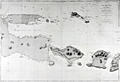 | Details | Depot de la Marine | 1880 |
| Antique chart of East Java and the Madura Strait |
|
Depot de la Marine |
|
| 1880 |
| LOC:0 |
| $450.00 | Depot-de-la-Marine | Antique-chart-of-East-Java-and-the-Madura-Strait | Antique French sea chart of east Java, Indonesia with the Strait of Madura, Lombok, <b>Bali</b> (Baly), and the <b>Kangean Archipelago</B>. A very attractive, large and clean antique nautical chart with finely-engraved detailed togography.
<br></br>
This chart was first issued by France's Depot de la Marine in 1862 and re-issued here with corrections in 1880. After an earler chart by Lt. Swann of the Royal Maraine Hollandaise. |
| 1256 |  | Details | Coronelli, Vincenzo | 1686 |
| 17th century map of Saronic Islands and Athens, Greece |
|
Coronelli, Vincenzo |
|
| 1686 |
| LOC:2 |
| $230.00 | Coronelli--Vincenzo | 17th-century-map-of-Saronic-Islands-and-Athens--Greece | Attractive map from 1686 of the Attic region and islands of the Saronic Gulf in the neighborhood of Athens, Greece. Major islands shown include Kea, Salamina, Egina, Makronisos, and Patroklos (Patrocleia). Other features Coronelli deemed important were Porto Rafti and the Temple of Minerva. Athens is shown as "Atene" just to the north of a very shrunken Athenian Peninsula. In the vicinity of today's port of Pireas, Greece only a single tower "torre" is shown along with a depiction of dots and crosses in the water signifying rocks or other low-lying navigational hazard.
<br></br>
This scarce wood-cut map was published by father Vincenzo Coronelli from Venice, Italy ca 1686 in "Memorie istoriografiche delli regni della Morea e Negroponte…".
<br></br>
Vincenzo Maria Coronelli (1650-1718) was an Italian Franciscan friar, cartographer, cosmographer and encyclopedist. Coronelli, a trained wood engraver, studied astronomy, Euclidean geometry and ancient philosophy and was named cosmographer for the Republic of Venice. He became most famous for his very large globes built in Paris from 1681-1683 at the order of King Louis XIV. His terrestrial and celestial globes measured 3.9 meters in diameter and were not equaled for more than 200 years. |
| 1255 | 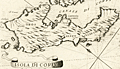 | Details | Coronelli, Vincenzo | 1686 |
| 17th century map of the Island of Corfu, Greece |
|
Coronelli, Vincenzo |
|
| 1686 |
| LOC:2 |
| $210.00 | Coronelli--Vincenzo | 17th-century-map-of-the-Island-of-Corfu--Greece | Fine antique map of the Greek island of Corfu which lies in the Ionian sea off Greece's northwest coast.
Key features on this attactive map of Corfu include the Canale di Corfu, the Fortezza (Fortress) di Corfu, and the villages of Agios Stefanos (s. Stefano), Scarpero (Skripero), Cauadales, Corissia (Lake Korission), and Neocon (Neochori).
<br></br>
This scarce wood-cut map was published by father Vincenzo Coronelli from Venice, Italy ca 1686 in "Memorie istoriografiche delli regni della Morea e Negroponte…".
<br></br>
Vincenzo Maria Coronelli (1650-1718) was an Italian Franciscan friar, cartographer, cosmographer and encyclopedist. Coronelli, a trained wood engraver, studied astronomy, Euclidean geometry and ancient philosophy and was named cosmographer for the Republic of Venice. He became most famous for his very large globes built in Paris from 1681-1683 at the order of King Louis XIV. His terrestrial and celestial globes measured 3.9 meters in diameter and were not equaled for more than 200 years. |
| 1222 | 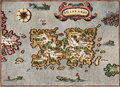 | Details | Porcacchi, Tomasso | 1576 |
| Scarce map of Puerto Rico, San Giovanni or Borichen |
|
Porcacchi, Tomasso |
|
| 1576 |
| LOC:5 |
| $350.00 | Porcacchi--Tomasso | Scarce-map-of-Puerto-Rico--San-Giovanni-or-Borichen | Fine sixteenth-century map of the Caribbean island of Puerto Rico, or Borichen as it was known by the indigenous Taino Indians. One of the earliest available maps specifically of Puerto Rico. San Juan is noted as S. Giovanni.
<br></br>
Contains the eastern coast of Cuba and a scattering of islands ( Le Vergini ) representing the British Virgin Islands. At bottom left is seen S. Croce (St. Croix). A large island off the southeast coast of Puerto Rico, "El Bacan" is probably the nearby island of Vieques. Numerous sea serpents swim in the offshore waters.
<br></br>
Printed in Tomasso Porcacchi's "Isolario" or island book "L'Isol Piu Famose Del Mondo". That work contains a number of finely engraved maps of islands and the continents at a reduced scale. Porcacchi (1530-1585) was born in Tuscany to a poor family and first settled in Florence. He wrote about history, geography, and archaeology and later published the Isolario from Venice, Italy in three editions beginning in 1572. Italian text on verso. |
| 1217 | 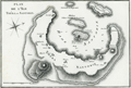 | Details | Benard, Robert | 1801 |
| Fine antique map of Santorini, Greece |
|
Benard, Robert |
|
| 1801 |
| LOC:0 |
| $170.00 | Benard--Robert | Fine-antique-map-of-Santorini--Greece | Very attractive map of the volcanic Greek island of <b>Santorini</b> ( Thera ) in the Aegean Sea. A very strong impression and meticulous attention to topographical detail make this an attractive candidate for framing.
<br></br>
Santorini lies within the Cyclades group of islands located in the southern part of the Aegean. The archipelago contains some 2,200 islands, islets and rocks but only 33 islands are inhabited.
<br?</br>
Includes the nearby islands of Thirasia, Palea Kameni and Nea Kameni. Numerous towns and villages within the island of Santorini are identified including:
<div class="indenttextblock">
<ul style="list-style-type: circle;">
<li>Apanomeria ( Oia )</li>
<li>Scauro</li>
<li>Phira ( Fira ) </li>
<li>Acrotiri or Akrotiri</li>
</ul>
</div>
From Guillaume Olivier: "Atlas Pour Servir au Voyage dans L 'Empire Othoman." Plate 7. |
| 1216 | 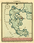 | Details | Luffman, John | 1801 |
| Plan of Corfu engraved for Luffman's Select Plans |
|
Luffman, John |
|
| 1801 |
| LOC:2 |
| $160.00 | Luffman--John | Plan-of-Corfu-engraved-for-Luffman-s-Select-Plans | Copper-plate engraved plan or map of the island of Corfu, Greece by John Luffman. Corfu is a Greek island in the Ionian Sea. The northeastern edge of Corfu lies off the coast of Sarandë, Albania, separated by straits varying in width from 2 to 14 miles.
<br></br>
The town of Corfu is depicted as surrounded by a Vauban-style fortified wall; it's harbor protected by a long 'mole' or breakwater. Coverage includes Castle St. Angelo, Porto Sideri, Porto Timoni, Porto Euripo, Porto Spilea, Formiche, Gudia Island, Condilonisi, and the Valley of St. Stefano.
<br></br>
Description at the bottom reads in part:
<div class="indenttextblock">
"<b>Corfu</b>, anciently Depane, Scheria, Phoeacia, and Corcyra is situated in the mouth of the Gulf of Venice, in the Mediterranean Sea. It was taken from the Venetians by Buonaparte in 1798 and by the Turks and Russians in 1799."
</div>
<br />
From "Luffman's Select Plans of the Principal Cities, Harbors, Forts etc. in the World". Engraved and published by John Luffman, No. 28 Little Bell Alley, Coleman Street, October 1, 1801. Number 15.
<br></br> |
| 1203 | 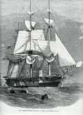 | Details | Illustrated London News | 1863 |
| Steam Corvette Racoon 22 Guns |
|
Illustrated London News |
|
| 1863 |
| LOC:0 |
| $130.00 | Illustrated-London-News | Steam-Corvette-Racoon-22-Guns | Fine wood engraving of the British Steam Corvette Racoon, 22 Guns. From the Illustrated London News published from London in 1863, during the hostilities to the west of the U.S. Civil War.
<br></br> Would frame nicely and present as a fine, thoughtful gift.
<br></br>
<div class="indenttextblock"> "Wood engraving is a printmaking and letterpress printing technique, in which an artist works an image or matrix of images into a block of wood. Functionally a variety of woodcut, it uses relief printing, where the artist applies ink to the face of the block and prints using relatively low pressure. By contrast, ordinary engraving, like etching, uses a metal plate for the matrix, and is printed by the intaglio method, where the ink fills the valleys, the removed areas. As a result, wood engravings deteriorate less quickly than copper-plate engravings, and have a distinctive white-on-black character." (Source: <a href="https://en.wikipedia.org/wiki/Wood_engraving" target="_blank">INTERNET</a> )
</div> |
| 1186 | 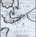 | Details | Aa, Pieter van der | 1719 |
| Scarce Antique Map of Hokkaido, Japan |
|
Aa, Pieter van der |
|
| 1719 |
| LOC:9 |
| $600.00 | Aa--Pieter-van-der | Scarce-Antique-Map-of-Hokkaido--Japan | Antique Dutch map of the island of Eso, today called Hokkaido, the northernmost of Japan's main islands. Printed on a large sheet measuring 19" W x 15" H.
<br></br>
Pieter van der Aa (1659 - 1733) was a Dutch publisher working in Leiden during the early eighteenth century. He is best known for publishing maps and atlases, though he also printed pirated editions of foreign bestsellers and illustrated volumes. From "Nouvel atlas...contenant les principales cartes géographiques dressées suivant les nouvelles observations de Mr. de l'Académie royale des sciences" published in 1714 from Leiden by Van der Aa. Plate number 27 (in manuscript). |
| 1187 | 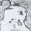 | Details | Aa, Pieter van der | 1719 |
| Scarce Antique Map of Banten in Java Indonesia |
|
Aa, Pieter van der |
|
| 1719 |
| LOC:9 |
| $300.00 | Aa--Pieter-van-der | Scarce-Antique-Map-of-Banten-in-Java-Indonesia | Antique Dutch map of the bay and village of "Bantam" or Banten, Java. Includes a plan of Bantam, and the smaller islands of Pulau Panjang, Groot P. Moby, Poele Don, Cleyn P. Moby, and Hollands kerk-hof. On a much larger sheet of watermarked (with fleur-de-lis), chain laid paper measuring 19" W x 15" H.
<br></br>
Pieter van der Aa (1659 - 1733) was a Dutch publisher working in Leiden during the early eighteenth century. He is best known for publishing maps and atlases, though he also printed pirated editions of foreign bestsellers and illustrated volumes. From "Nouvel atlas...contenant les principales cartes géographiques dressées suivant les nouvelles observations de Mr. de l'Académie royale des sciences" published in 1714 from Leiden by Van der Aa. Plate number 19 (in manuscript). |
| 1177 | 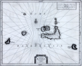 | Details | Aa, Pieter van der | 1719 |
| Antique map of the Banda Islands, Indonesia |
|
Aa, Pieter van der |
|
| 1719 |
| LOC:9 |
| $880.00 | Aa--Pieter-van-der | Antique-map-of-the-Banda-Islands--Indonesia | Rare Dutch map / chart of the Banda Islands, part of the Indonesian province of Maluku, comprising the important Spice Islands. The Banda Islands are part of the Moluccas archipelago to the west of New Guinea. Until the mid-19th century the Banda Islands were the world's only source of the spices nutmeg and mace, produced from the nutmeg tree.
<br></br>
Pieter van der Aa (1659 - 1733) was a Dutch publisher working in Leiden during the early eighteenth century. He is best known for publishing maps and atlases, though he also printed pirated editions of foreign bestsellers and illustrated volumes. From "Nouvel atlas...contenant les principales cartes géographiques dressées suivant les nouvelles observations de Mr. de l'Académie royale des sciences" published in 1714 from Leiden by Van der Aa. Plate number 27 (in manuscript).
<br></br>
Printed on a large sheet measuring 19" W x 15" H. |
| 502 | 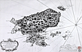 | Details | Depot de la Marine | 1763 |
| Plan de l'ile de Saint Pierre au Sud De Terre-Neuve |
|
Depot de la Marine |
|
| 1763 |
| LOC:65 |
| $550.00 | Depot-de-la-Marine | Plan-de-l-ile-de-Saint-Pierre-au-Sud-De-Terre-Neuve | Antique French sea chart of the island of Saint Pierre about 25 miles south of Newfoundland, in the northwestern Atlantic Ocean.. Lying just offshore of Saint Pierre are numerous smaller islands including Le Grand Colombier; Isle aux Chiens, Isle aux Pigeons, and the gruesomely named "Isle Massacre". The small village is referred to as "le Bourg".
<BR> </BR>
Several features on this chart suggest it was rushed into production. These features include numerous small rectangular areas where the engraving had been smoothed and then re-engraved with place names or descriptors, and at least one area where the chart was smoothed but then left blank. These new additions include "Teste de Galantry"; "Broussailles" ( Fr. Brush wood); and "Bois de Chaufage" (Fr. Heating wood).
<BR> </BR>
In the year this chart was published, 1763, under the terms of the Treaty of Paris, France ceded all its North American possessions, but Saint-Pierre and Miquelon were returned to France. Saint Pierre and Miquelon is today a self-governing overseas territory of France.
<BR> </BR>
Large decorative title cartouche at bottom left is adorned with garlands. Rhumb lines extend from a simple compass rose at right. At bottom right the anchor stamp of the Depot de la Marine and a later red hand-stamp of the "Military Depot" containing the royal coat of arms of the United Kingdom: a shield and crown flanked by a lion and unicorn. |
| 1087 | 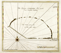 | Details | van Keulen, Johannes | 1753 |
| Scarce Dutch Chart of Cosmoledo Atoll, Seychelles |
|
van Keulen, Johannes |
|
| 1753 |
| LOC:6 |
| $275.00 | van-Keulen--Johannes | Scarce-Dutch-Chart-of--Cosmoledo-Atoll--Seychelles | Rare antique "secret" chart of the raised coral atoll of <b>Cosmoledo</b> of the Aldabra Group, belonging to the Outer Islands of the Seychelles. The name Cosmoledo is said to honor a Portuguese navigator, who was part of Juan de Nova's crew. De Nova was a Galician explorer of the Atlantic and Indian Oceans at the service of Portugal. He is credited as the discoverer of Ascension and Saint Helena islands.
<br></br>
The chart is very sparse showing only a thin circle of land ringing the atoll with five palm trees and a related few notes. No soundings .
<br></br>
From the sixth part of van Keuelen's "<b>de Nieuwe Groote Lichtende Zee-Fakkel</b>" based on secret charts of the <b>Dutch East India Company</b> (Vereenigde Oost-Indische Compagnie or <b>VOC</b>). Prior to the mid-18th century these charts were only disseminated in manuscript to safeguard what the VOC considered to be its proprietary trade secrets. The Dutch East India Company was the dominant trade force in Asia for nearly 200 years.
<br></br>
Bears the attribution at bottom: "In't ligt gebragt door Joannes van Keulen". |
| 1084 | 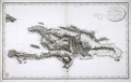 | Details | Depot de la Marine | 1803 |
| Antique French Chart of the Dominican Republic and Haiti |
|
Depot de la Marine |
|
| 1803 |
| LOC:51 |
| $750.00 | Depot-de-la-Marine | Antique-French-Chart-of-the-Dominican-Republic-and-Haiti | Old French map of Saint Dominque- the island of Hispaniola not yet divided into political entities of Haiti and the Dominican Republic. Topography is shown in relief with extensive shading and hachuring. There is extensive depiction of the roads, rivers, and towns that populate the interior of the island. While the map does provide the user with visual geographic details, the is no information either of elevation of the terrain, nor are there any depth soundings.
<br</br>
The map was published by the Depot de la Marine in "An XI" - the 11th year after the French Revolution of 1803. Two changes on the map from an earlier edition of the same map published before the revolution are that the Depot de la Marine logo incorporates the letters "R.F." (Republique francaise) and the town previously denoted as "Port au Prince" is called "Port Republicain" in the post-revolutionary edition. |
| 1074 | 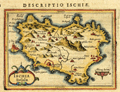 | Details | Bertius, Petrus | 1616 |
| Antique map of the island of Ischia in the Bay of Naples |
|
Bertius, Petrus |
|
| 1616 |
| LOC:4 |
| $150.00 | Bertius--Petrus | Antique-map-of-the-island-of-Ischia-in-the-Bay-of-Naples | Small detailed, 400 year-old map of the volcanic island of Ischia which lies off the coast of Naples, Italy. Ischia is the largest of three islands that lie in or near the Gulf of Naples: Ischia, Capri, and Procida. At the east end of the island is shown the Aragonese Castle built in the year 474.
<br></br>
From the Latin edition of Bertius' 'Tabularum geographicarum contractarum..' |
| 1076 |  | Details | British Admiralty Hydrographical Office | 1926 |
| Antique British Chart of the Caribbean Sea and West Indies |
|
British Admiralty Hydrographical Office |
|
| 1926 |
| LOC:61 |
| $750.00 | British-Admiralty-Hydrographical-Office | Antique-British-Chart-of-the-Caribbean-Sea-and-West-Indies | Spectacular large and original early twentieth-century nautical chart of south Florida and the Caribbean. Points in the USA include towns south of Orlando: Tampa, Cape Canaveral, Key West , Lake O-kee-cho-bee, and much more. Includes the islands of Jamaica, Cuba, Hispaniola, the Bahamas, Turks and Caicos. Hundreds of soundings and navigational hazards are identified.
<br></br>
Later edition of a British Admiralty chart first engraved and published from London in 1876. This bold, dark print retains the cartographic look and style of the late 19th century with updated hand-coloring by a professional map colorist. More recent charts do not display the character of this beauty.
<br></br>
Oval logo of the British Hydrographical office at upper right. Price when sold was three shillings. Chart number 761. Sold by J.D. Potter. |
| 1102 |  | Details | Loots, Johannes | 1700 |
| Pascaerte vande Vlaemsche Eylanden |
|
Loots, Johannes |
|
| 1700 |
| LOC:9 |
| $2,500.00 | Loots--Johannes | Pascaerte-vande-Vlaemsche-Eylanden | Singular rare nautical chart of the Azores Islands (Vlaemsche = Flemish) by Dutch cartographer Johannes Loots, ca 1700. Pascaerte vande Vlaemsche Eylanden is not recorded in Koeman's Atlantes Neerlandici. <B>No record of another copy of this chart is found online or in cartograhic reference sources.</b> Charts by Johannes Loots are very scarce; only eight charts by Loots are recorded in the Antique Map Price Record covering 210,000 map and chart sales in the last 35 years.
<br></br>
Scrollwork title cartouche with putto and horses led by robed young men and topped with an armillary sphere on a pedestal.
<br></br>
The topography of the Azores islands closely resembles that on an an earlier chart with the same title produced by Arnold Colom but differences in the rhumb lines, cartouches, lattitude marks, compass roses and decorations strongly suggest that this chart was printed from a new plate engraved for Loots.
<br></br>
From Koeman's biography of Johanne's Loots (1665[6] - 1726) we know Loots was born in Amsterdam and is not as is sometimes believed one of the two sons of Anthonie (Theunisz) Jacobsz who named themselves Lootsman to confuse cartographic researchers in future centuries. Loots served an apprenticeship under Hendrick Doncker as a maker of mathematical and nautical instruments including cross-staffs. Loots was accepted into the Guild of Booksellers in 1693 and settled into a shop in the Nieuebrugsteeg 'In de Jong Lootsman'. Two well-known competing catographers lived on the same street- Johannes van Keulen and Hendrick Doncker. |
| 1049 |  | Details | Depot de la Marine | 1774 |
| Large antique French sea chart of the Caribbean and Gulf of Mexico |
|
Depot de la Marine |
|
| 1774 |
| LOC:61 |
| $1,750.00 | Depot-de-la-Marine | Large-antique-French-sea-chart-of-the-Caribbean-and-Gulf-of-Mexico | Beautiful second edition (1774) of Bellin's important map of the Caribbean, Central America, and Gulf Coast, which is substantially revised and updated from the first edition issued by Bellin in 1749. Most notable feature on this stunning 18th century survivor is that south Florida is depicted as a mass of islands. The concept of the Florida archipelago derives from the work of Father Francois Le Maire, a missionary who arrived in Louisiana in June 1706.
<br></br>
In the title block the date has been partially erased from the original plate, causing some confusion that this chart might date to the 17th year of the French Revolution (1806). This is not the case. The attribution to the Duc du Paslin, the lack of R.F. in the circular Depot logo, and the depiction of Florida as an archipelago are all consistent with the Library of Congress' date for this map of 1774. (Library of Congress Map Diivision. "A List of Maps of America in the Library of Congress". 1901. p. 423. Retrieved online 3/2016) |
| 1030 |  | Details | Allezard, Jean Joseph | 1817 |
| Antique chart of Mykonos, Greece |
|
Allezard, Jean Joseph |
|
| 1817 |
| LOC:2 |
| $145.00 | Allezard--Jean-Joseph | Antique-chart-of-Mykonos--Greece | Antique chart / plan of the Aegean island of Mikonos / Mykonos, Greece along with the northwestern portion of Delos, famous for its important archeological site and in mythology the birthplace of the twin gods Apollo and Artemis. Maps shows the village of Mykonos and a single building off in the distance labeled "Calori".
<br></br>
One of 163 plates of ports on the Mediterranean, Adriatic and Black seas from Allezard's atlas "Recueil de 163 des principaux plans des ports et rades de la Mediterranée, dont 40 ont été derniérement publiés par Jean Joseph Allezard ancien capitaine de marine et plusieurs des autres corrigés" . This atlas was a re-issue of Joseph Roux's atlas published from Marseille in several editions beginning in 1764. Published by Joseph Gamba from Livorno, Italy. Plate 141. |
| 1032 | 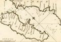 | Details | Allezard, Jean Joseph | 1811 |
| Chart of Corfu by Allezard |
|
Allezard, Jean Joseph |
|
| 1811 |
| LOC:2 |
| $165.00 | Allezard--Jean-Joseph | Chart-of-Corfu-by-Allezard | Antique chart / plan of the Ionian island of Corfu, Greece, the second largest of the Ionian islands. Includes a portion of the west coast of mainland Greece.
<br></br>
Very interesting note by Allezard at the far northwest of the mainland: "Cent quarante les 3 ecolles". Turns out that the area is Sarande, Albania and that the note is a reference to a Byzantine monastery "the Forty Saints" , honoring the "Forty Martyrs of Sebaste" leading to the Italian name "Santi Quaranta" which Allezard spelled phonetically "Cent Quarante".
<br></br>
One of 163 plates of ports on the Mediterranean, Adriatic and Black seas from Allezard's atlas "Recueil de 163 des principaux plans des ports et rades de la Mediterranée, dont 40 ont été derniérement publiés par Jean Joseph Allezard ancien capitaine de marine et plusieurs des autres corrigés" . This atlas was a re-issue of Joseph Roux's atlas published from Marseille in several editions beginning in 1764. Published by Joseph Gamba from Livorno, Italy. Plate 49. |
| 1017 | 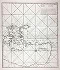 | Details | Anonymous | |
| Anonymous French chart of the east Mediterranean sea Sheet III |
|
Anonymous |
|
|
| LOC:58 |
| $800.00 | Anonymous | Anonymous-French-chart-of-the-east-Mediterranean-sea-Sheet-III | Interesting possibly unrecorded chart of the eastern Mediterranean Sea labeled "Feuille III" (Sheet 3.) Labels the key regions "Romanie, Caramanie, Natolie, Syrie". The regional naming and the area covered are generally consistent with those on the third (eastern) sheet of Bellin's "Carte de la Mer Mediterranee en Trois Feuilles" published in 1745 (based on Grognard's survey). This chart is nicely engraved and is printed on heavy wove paper, all signs of a quality in a published chart of that era.
<br></br>
However, although this chart bears the designation "Feuille III" and uses the French language, it is different in many ways. This chart is untitled, uses portrait format rather than landscape format, and displays very different geography- omits many key geographic features and places other features in different locations (e.g.. Isle Provencale near Alexandrette). Also significant is the absence of a distance scale and in the location where the title block is typically found, a list of eight islands with the comment that the list is of islands between the meridian of Cape St. Ange and Alexandrette (Iskenderun, Turkey). |
| 1011 |  | Details | Depot de la Marine | 1791 |
| French Chart of the Azores Island, Portugal |
|
Depot de la Marine |
|
| 1791 |
| LOC:54 |
| $750.00 | Depot-de-la-Marine | French-Chart-of-the-Azores-Island--Portugal | Antique chart from 1791 of the Azores Islands, off the coast of Portugal. This chart "Carte réduite des Isles Açores" is a 1791 French sea chart based on the earlier observations of Tofino de San Miguel, of the Spanish Admiralty. Contains numerous elevation profile views of the Azores coastline as seen from sea. Coverage inccludes the islands of Corvo, Flores, Graciosa ("Gracieuse"), Terceira, São Jorge, Pico, Faial, São Miguel, and Santa Maria. |
| 977 | 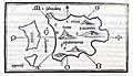 | Details | Bordone, Benedetto | 1534 |
| Very old wood-cut map of the island of Santorini, Greece |
|
Bordone, Benedetto |
|
| 1534 |
| LOC:2 |
| $600.00 | Bordone--Benedetto | Very-old-wood-cut-map-of-the-island-of-Santorini--Greece | An early map of the Greek Aegean Island of Santorini ("S. Erini") in the Cycladic Island group. Opposite the caldera from Thira is the smaller island of Thirasia ("Tiresia"). Shows four villages: Oia ("San Salvadore"), Pyrgos ("Scaro"), Akrotiri ("Acortiri") and "Apanomerca".
<br></br>
Shows a jagged set of lines on the west coast of the island similar to the letter "M" set on its side. From the location it almost certainly represents the switchback road leading down the cliff face to the beach and ferry station; a feature most tourists to the island who arrive by boat will well remember.
<br></br>
Map is inset onto a full page of Italian text. Verso contains another similar-sized map of the Cycladic island of "Namphio" (present-day Anafi) which lies just a few miles to the east of Santorini.
<br></br>
This scarce antique map was published from Venice in 1534, just 42 years after Christopher Columbus first landed in the New World. From the second edition of Benedetto di Bordone's "Isolario" which provided nautical-chart inspired maps of islands alongside information for travellers on their culture, myths, climate, and history.
<br></br>
Bordone (1460-1531) was a Paduan cartographer, and an illustrator of manuscripts, best known for his 'Isolario' or book of islands. Bordone's work was only the second isolario ever printed, the first being that of Bartolommeo Dalli Sonneti published in 1485. Text on verso in Italian. |
| 942 | 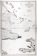 | Details | Direccion Hidrografia | 1867 |
| Antique Spanish Chart of Eastern Cuba and the Bahama Bank |
|
Direccion Hidrografia |
|
| 1867 |
| LOC:0 |
| $900.00 | Direccion-Hidrografia | Antique-Spanish-Chart-of-Eastern-Cuba-and-the-Bahama-Bank | Striking antique Spanish sea-chart of the southeastern Bahamas. This attractive 150 year old nautical artifact would make a fine gift for yachtsmen, fishermen, and sailors with an interest in the waters near the Windward Passage, the 50 mile-wide strait between Cuba and Hispaniola connecting the Atlantic Ocean and the Caribbean Sea.
<br></br>
This venerable nautical survivor includes western Haiti, eastern Cuba, east Jamaica, and the Inagua Islands. Covers the southern portion of the Great Bahama Bank, Grand Inagua Island, Little Inagua Island, Crooked Island, Acklins Island, Rum Cay, Conception Island, Mayaguana, Great Exuma; Providenciales, Turks and Caicos; Cat Island, San Salvador Islands ("Isla Watlings") , and the southern part of Eleuthera ("Isla Hetera"). Key cities noted include Kingston, Jamaica; Port-au-Prince ("Puerto Principe"), Haiti; Baracoa and Santiago de Cuba, Cuba.
<br></br>
Certainly a fine example of a mid-nineteenth century working navigational chart with numerous soundings, particularly in the area of the Great Bahama Bank. Nine lighthouses are identified with red and yellow highlights. Originally issued in 1856, this edition was printed with additions and corrections in 1867 by Spain's official maritime agency, the Direccion Hidrografia. |
| 935 | 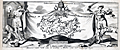 | Details | Peeters, Jan | 1680 |
| Decorative antique map of Crete, Greece |
|
Peeters, Jan |
|
| 1680 |
| LOC:2 |
| $190.00 | Peeters--Jan | Decorative-antique-map-of-Crete--Greece | Antique frontispiece with the island of Crete, Greece (Candia) published from Antwerp by Peeters in a volume with several prints of views of key cities on Crete. Map of the key Greek island of Crete with the labyrinth ("laberinta") of King Minos identified in the middle of the island. Names several important cities including "Canea" (Chania), "Candia" (Iraklio), "Fenice", "Penico" and "Matoli".
<br></br>
Set among a scene depicting the aftermath of a battle with two figures holding a sheet with the coat of arms of Pope Innocent XI ("Innocentius XI Pontifex Maximus"). One of the figures appears to be a representation of a Turk with a scimitar standing on the holy Christian cross, representing the conflict between the Ottoman Empire and Venice for control of Crete in the 17th century.
<br></br>
Attribution reads: "I. Peeters excudit- Antverpi." Conrad Lauwers sculp. |
| 928 | 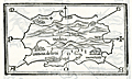 | Details | Bordone, Benedetto | 1534 |
| Early maps of Madeira and Ptolemaic Canary Islands |
|
Bordone, Benedetto |
|
| 1534 |
| LOC:7 |
| $950.00 | Bordone--Benedetto | Early-maps-of-Madeira-and-Ptolemaic-Canary-Islands | Two antique maps, one of Madeira, an island of Portugal in the Atlantic Ocean, and a curious map of the Atlantic islands on Africa's west coast based on the names and locations used by the Greeks and Romans. On the recto is the first printed map of the Portugese island of Madeira, by Benedetto Bordonne. Bordonne depicts the island as mountainous with numerous trees, and names four villages: "Camera de Lioni" (Câmara de Lobos); Fonzal" (Funchal); "Santa" (Sao Vincente); "Monerico" (Machico).
<br></br>
In his "Geography", Claudius Ptolemy, the Greco-Egyptian geographer lists a number of islands and their geographic coordinates. The verso contains one of the first printed maps showing the location of the Atlantic islands with Ptolemy's place names or that of the of the Roman geographer Pliny including: "Autolala" (Madeira), "Ninguaria" (Tenerife), "Canaria" (Gran Canaria), "Iunone" (Lanzarote or Fuerteventura), "Ombrio" (Ferro), and "Cisperia" (La Gomera). (Smith, William. <B>Dictionary of Greek and Roman Geography</b>. London. 1869. <a href="https://books.google.com/books?id=xgtAAQAAMAAJ&pg=PA906&lpg=PA906&dq=roman+names+for+canary+islands&source=bl&ots=2tZo3281lY&sig=rABlSnYBibeSpYSIR0SmvJp67Ms&hl=en&sa=X&ved=0CEMQ6AEwCDgKahUKEwjR28e1zerIAhXBJCYKHQ7VClc#v=onepage&q=906&f=false" target="_blank">Internet.)</a>
<br></br>
From the second Zoppino edition of Benedetto di Bordone's "<b>Isolario di Benedetto Bordone</b>" . This scarce antique map was published from Venice in 1534, just 42 years after Christopher Columbus first landed in the New World. The Isolario provided maps of islands alongside information for travellers on their culture, myths, climate, and history.
<br></br>
Bordone (1460-1531) was a Paduan cartographer, and an illustrator of manuscripts, best known for his 'Isolario' or book of islands. Bordone's work was only the second isolario ever printed, the first being that of Bartolommeo Dalli Sonneti published in 1485. |
| 929 | 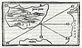 | Details | Bordone, Benedetto | 1534 |
| Early map of Porto Santo Island in the Madeira archipelago |
|
Bordone, Benedetto |
|
| 1534 |
| LOC:7 |
| $350.00 | Bordone--Benedetto | Early-map-of-Porto-Santo-Island-in-the-Madeira-archipelago | Antique woodcut printed map of Porto Santo off the west coast of Africa in the Atlantic ocean. One of the earliest printed maps solely devoted to Porto Santo island, in the Portugese Madeira island group. By Benedetto Bordonne, who shows Porto Santo, Portugal in its geographical context with Madeira to the south and the west coast of Africa or "Getulia" to the east. Show several villages scattered around the island.
<br></br>
On a full sheet of Italian text. From the second Zoppino edition of Benedetto di Bordone's "<b>Isolario di Benedetto Bordone</b>" . This scarce antique map was published from Venice in 1534, just 42 years after Christopher Columbus first landed in the New World. The Isolario provided maps of islands alongside information for travellers on their culture, myths, climate, and history.
<br></br>
Bordone (1460-1531) was a Paduan cartographer, and an illustrator of manuscripts, best known for his 'Isolario' or book of islands. Bordone's work was only the second isolario ever printed, the first being that of Bartolommeo Dalli Sonneti published in 1485. |
| 925 | 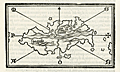 | Details | Bordone, Benedetto | 1534 |
| First printed map of the Caribbean island of Hispaniola |
|
Bordone, Benedetto |
|
| 1534 |
| LOC:5 |
| $900.00 | Bordone--Benedetto | First-printed-map-of-the-Caribbean-island-of-Hispaniola | The first printed large-scale map of the Caribbean island of <b>Hispaniola</b> which is shared by two nations: the Dominican Republic and Haiti. Also the first printed map to show the earliest settlement in the New World (other than a Viking settlement)- <b>La Isabela</b> ("Isabella"). During his second voyage in 1493 Christopher Columbus founded La Isabela on the central north coast of Hispaniola, in what is today the Dominican Republic. Map is inset onto a full page of Italian text.
<br></br>
This scarce antique map was published from Venice in 1534, just 42 years after Christopher Columbus first landed in the New World. From the second edition of Benedetto di Bordone's "Isolario di Benedetto Bordone Nel qual si ragiona di tutte l'Isole del mondo, con li lor nomi antichi & moderni, historie, favole, & modi del loro vivere, & in qual parte del mare stanno, & in qual parallelo & clima giaciono. Con la gionta del Monte del Oro novamente ritrovato". The Isolario provided nautical-chart inspired maps of islands alongside information for travellers on their culture, myths, climate, and history. Bordonne depicts the interior of the island as mountainous with numerous rivers flowing to the sea.
<br></br>
Bordone (1460-1531) was a Paduan cartographer, and an illustrator of manuscripts, best known for his 'Isolario' or book of islands. Bordone's work was only the second isolario ever printed, the first being that of Bartolommeo Dalli Sonneti published in 1485. Text on verso in Italian. |
| 926 |  | Details | Bordone, Benedetto | 1534 |
| Early printed map of South America with Hispaniola and Jamaica |
|
Bordone, Benedetto |
|
| 1534 |
| LOC:5 |
| $800.00 | Bordone--Benedetto | Early-printed-map-of-South-America-with-Hispaniola-and-Jamaica | One of the earliest printed maps and the first obtainable map of the <b>South American continent</b>. South America is not recognizable as such but it closely compares to Rosselli's world map of 1508 from which Bordonne derived the shape.
<br></br>
Includes the Caribbean islands of <b>Jamaica</b> ("Iamaiqua") and <b>Hispaniola</b> ("Spagnola"). Within the truncated area of South America, Bordonne names four major regions which he discussed in the text: "Chanchite", (in the vicinity of present-day Colombia), "Cuztana", "Maziatombal" (associated with the Amazon River), and "Paria" (which may be related to the eastern portion of Venezuela).
<br></br>
This scarce antique map was published from Venice in 1534, just 42 years after Christopher Columbus first landed in the New World. From the second edition of Benedetto di Bordone's "Isolario di Benedetto Bordone Nel qual si ragiona di tutte l'Isole del mondo, con li lor nomi antichi & moderni, historie, favole, & modi del loro vivere, & in qual parte del mare stanno, & in qual parallelo & clima giaciono. Con la gionta del Monte del Oro novamente ritrovato". The Isolario provided nautical-chart inspired maps of islands alongside information for travellers on their culture, myths, climate, and history. Bordonne depicts the interior of the island as mountainous with numerous rivers flowing to the sea.
<br></br>
Bordone (1460-1531) was a Paduan cartographer, and an illustrator of manuscripts, best known for his 'Isolario' or book of islands. Bordone's work was only the second isolario ever printed, the first being that of Bartolommeo Dalli Sonneti published in 1485. Text on verso in Italian. |
| 927 |  | Details | Bordone, Benedetto | 1534 |
| Early map of the Canary Islands and Cape Verde Islands |
|
Bordone, Benedetto |
|
| 1534 |
| LOC:7 |
| $950.00 | Bordone--Benedetto | Early-map-of-the-Canary-Islands-and-Cape-Verde-Islands | The first small-scale printed map to name the individual <b>Canary Islands</b> now part of Spain, and the Portugese <b>Cape Verde Islands</b>. Both groups of islands are shown in the Atlantic Ocean on a single map with part of Africa.
<br></br>
At right Bordonne shows the coast of Africa and names the on-shore regions "Getulia", "Argin" (Arguin ?), and "Libya di Sotto". Bordonne's names for the main Canary Islands and their modern equivalents are: "Palma" (La Palma), "Agore" (La Gomera), "Tinerif" (Tenerife), "Canaria" (Gran Canaria), "Forte Ventura" (Fuerteventura), and "Lazazoto" (Lazarote).
<br></br>
At bottom left are the most northern of the Cape Verde Islands, or the Ilhas de Barlavento:
"S. Antonio" ( Santo Antão),"S. Vincenzio" (São Vicente), "S. Jacopo" ("Santa Luzia"), "S. Nicolo" (São Nicolau). Some islands shown close to the coast are more difficult to account for: "I. Bianca" (Sal ?), "I. delle Gaze" (Boa Vista ?) and "Cuori".
<br></br>
From the second Zoppino edition of Benedetto di Bordone's "<b>Isolario di Benedetto Bordone</b> Nel qual si ragiona di tutte l'Isole del mondo, con li lor nomi antichi & moderni, historie, favole, & modi del loro vivere, & in qual parte del mare stanno, & in qual parallelo & clima giaciono. Con la gionta del Monte del Oro novamente ritrovato". This scarce antique map was published from Venice in 1534, just 42 years after Christopher Columbus first landed in the New World. The Isolario provided nautical-chart inspired maps of islands alongside information for travellers on their culture, myths, climate, and history.
<br></br>
Bordone (1460-1531) was a Paduan cartographer, and an illustrator of manuscripts, best known for his 'Isolario' or book of islands. Bordone's work was only the second isolario ever printed, the first being that of Bartolommeo Dalli Sonneti published in 1485. Text on verso in Italian. |
| 922 |  | Details | Bordone, Benedetto | 1534 |
| Very early chart of Lesbos or Lesvos, Greece |
|
Bordone, Benedetto |
|
| 1534 |
| LOC:2 |
| $375.00 | Bordone--Benedetto | Very-early-chart-of-Lesbos-or-Lesvos--Greece | One of the earliest printed maps of <b>Lesbos / Lesvos</b>, a Greek island in the northeastern Aegean Sea on a full page of text. Oriented with the east at the top, coverage includes Lesbos, and across the Edremit Gulf ("Colpho Adramatino"), the Ayvacik district of the Çanakkale Province of Turkey.
<br></br>
Perhaps the most interesting feature is that Bordone's map may be the earliest printed map to locate and name the Homeric <b>Bronze-age city of Troy</b>, although Bordone places Troy a bit farther south than its true location. On the mainland, in Turkey, near "Capo S. Maria" or present-day Babakale, the map shows a site "troia" with broken columns indicating ruins. Sonetti published an earlier map of Lesbos which inspired Bordone's map but there is no indication of ruins in that location, nor are there place names.
<br></br>
Shows the capital of <b>Mitilini / Mytilene ("Metelini")</b> somewhat misplaced to the northeast of the island. A bit to the west (on Bordonne's map) of Mitilini "la tore in mare" denotes a lighthouse in the sea. Nearby Mitilini, Bordone locates a hilltop church "Saint Theodoro". Saint Theodore is the patron saint of Mytilini.
<br></br>
Published from Venice in 1534 in the second edition of Benedetto di Bordone's 'Isolario', or "Island Book". The various editions of the Isolario were published using the same wood-block plates and each edition is differentiated from the other by the location of the page breaks within the text. The Isolario provided nautical-chart inspired maps of islands alongside information for travellers on their culture, myths, climate, and history.
<br></br>
Bordone (1460-1531) was a Paduan cartographer, and an illustrator of manuscripts, best known for his 'Isolario' or book of islands. Bordone's work was only the second isolario ever printed, the first being that of Bartolommeo Dalli Sonneti published in 1485. Text in Italian. |
| 923 |  | Details | Bordone, Benedetto | 1534 |
| Very early map of Cadiz, Spain and the Azores, Portugal |
|
Bordone, Benedetto |
|
| 1534 |
| LOC:4 |
| $575.00 | Bordone--Benedetto | Very-early-map-of-Cadiz--Spain-and-the-Azores--Portugal | One of the earliest printed Azore Island maps (and another map of Cadiz, Spain) on a single sheet. Published from Venice in 1534 in the second edition of <b>Benedetto di Bordone's</b> nautical "Isolario", or Island Book.
<br></br>
The Isolario provided nautical-chart inspired maps of islands alongside information for travellers on their culture, myths, climate, and history.
<br></br>
A fine and original early nautical map of the <b>Azores islands</b>, in the Atlantic Ocean about 850 miles west of Portugal. Three islands on Bordonne's Azores map can be traced to their present-day equivalents: "S. Maria" (Santa Maria), "S. Georgio" (Sao Jorge), and "Samguimi" (Sao Miguel). Also shows the <b>mythical islands</b> of "Asmaida" and "Brasil" or Hy-Brazil as is is called in modern cartographic literature. Brasil island was long imagined to be located somewhere in the Atlantic Ocean to the west of Ireland. Brasil appears on several manuscript Portolani from the 14th and 15th century by Angelino Dulcert (1325), Andrea Bianco (1436) and others. Over almost 200 years several expeditions to find the Brasil were conducted by John Cabot, John Jay and others but as it was only an imaginary island the explorations failed.
<br></br>
Bordone's map of <b>Cadiz, Spain</b> (verso) is very interesting for its early place in the evolution of the cartography of that region. This map is almost cartoon-like in its simplicity. With the "Stretto de Gibilterra" defining the right limit of the map, and the "Regno de Castiglia" above, Cadiz is shown as a simple crescent shape slightly separated from the mainland. Towns that Bordone noted include "Gades" (Cadiz) , Turs, Tola, and S. Maria.
<br></br>
Bordone (1460-1531) was a Paduan cartographer, and an illustrator of manuscripts, best known for his 'Isolario' or book of islands. Bordone's work was only the second isolario ever printed, the first being that of Bartolommeo Dalli Sonneti published in 1485. Text in Italian. |
| 924 | 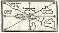 | Details | Bordone, Benedetto | 1534 |
| Very early map of the Leeward Islands of the Lesser Antilles |
|
Bordone, Benedetto |
|
| 1534 |
| LOC:5 |
| $940.00 | Bordone--Benedetto | Very-early-map-of-the-Leeward-Islands-of-the-Lesser-Antilles | The first printed maps of the Caribbean islands of St. Martin and Guadeloupe, published just 42 years after Christopher Columbus first landed in the New World. An attractive group of three antique maps inset on a single sheet with Italian text on verso and recto.
<br></br>
The recto includes a small-scale chart of the Leeward Islands. Here the geographical relationship of the islands bears little resemblance to present-day maps. Bordonne names the islands: "S. Maria Rotonda"; "Moserato" or Montserrat; "Buchima" or "Barbuda"; "Dominica"; S. Maria Antica" or Antigua; "Santa" or "Saint Kitts?; and "C. Martino" or St. Martin.
<br></br>
Two additional maps on the verso show the islands of "Guadalupe" Guadeloupe and "Matinina" or St. Martin. Each island is decorated with features that Bordonne addresses in the text. Guadeloupe is shown covered with a low leafy vegetation. St. Martin sports numerous caves set into small hills.
<br></br>
Published from Venice in 1534 in the second edition of Benedetto di Bordone's "Isolario", or Island Book. The Isolario provided nautical-chart inspired maps of islands alongside information for travellers on their culture, myths, climate, and history.
<br></br>
Bordone (1460-1531) was a Paduan cartographer, and an illustrator of manuscripts, best known for his 'Isolario' or book of islands. Bordone's work was only the second isolario ever printed, the first being that of Bartolommeo Dalli Sonneti published in 1485. Text in Italian. |
| 913 | 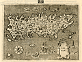 | Details | Porcacchi, Tomasso | 1576 |
| Island of Candia (Crete) in Greece |
|
Porcacchi, Tomasso |
|
| 1576 |
| LOC:2 |
| $275.00 | Porcacchi--Tomasso | Island-of-Candia-(Crete)-in-Greece | Very interesting early antique map of the Greek Mediterranean island of Candia (Crete or Kriti), the largest island in Greece. This late 16th century map, by Tomasso Porcacchi, shows some of the largest towns on the island at that time: Cania (Chania), Retimo (Rethimno), and Candia (Iraklio). Numeous small islands and islets are named offshore including Morena, Farioni, Paxmando, and Standia. In the stippled sea, empty space is filled with fanciful sea creatures, huge sea snails, crabs, and a three-masted galleon.
<br></br>
At the center of the map is a cicular design of a maze south of the town of Candia (Iraklio or Heraklion). That maze is a reference to the labyrinth of King Minos of Crete that was believed to be located at the palace at Knossos. Since classical times that site was believed to be the location where Daedalus built the labyrinth for King Minos to hold the mythical Minotaur.
<br></br>
The entrance to three caves is depicted near the southwest coast in the general vicinity of the well-known Samaria Gorge. At that spot Porcacchi has noted: "Habitation d' homini e bestiami nelle chuerne" or the dwelling of men and cattle in ?chuerne.
<br></br>
Printed in Tomasso Porcacchi's "Isolario" or island book "L'Isol Piu Famose Del Mondo". That work contains a number of finely engraved maps of islands and the continents at a reduced scale. Porcacchi (1530-1585) was born in Tuscany to a poor family and first settled in Florence. He wrote about history, geography, and archaeology and later published the Isolario from Venice, Italy in three editions beginning in 1572. Page 108. |
| 914 | 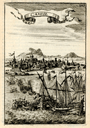 | Details | Mallet, Allain Manesson | 1683 |
| Candie |
|
Mallet, Allain Manesson |
|
| 1683 |
| LOC:2 |
| $85.00 | Mallet--Allain-Manesson | Candie | Small, attractive antique view of the harbor of Candia (Heraklion or Iraklio) on Crete, Greece with mosques and other buildings surmounted by the cresent moon of the Ottoman Caliphate. Galleys and other warships battle offshore in the Mediterranean Sea and the smoke of cannon fire indicate a westerly breeze. By Allain Mallet, Paris, 1683.
<br></br>
The Ottomans captured most of Crete during the early years of the Cretan War (1645-1669) but the Venetians retained control of the capital, Candia, until the very end in 1669. This engraved view probably captures a moment in the final battle for control of Heraklion. Page 203.
<br></br>
Published by Mallet in "Description de l'Univers" . Allain Mallet (1630-1706) was a French engineer, soldier, and cartographer. He served in the court of King Louis XIV as a techer of mathematics. In addition to "Description de l'Univers" Mallet also published "Les Travaux de Mars ou l'Art de la Guerre". |
| 915 | 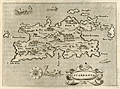 | Details | Porcacchi, Tomasso | 1576 |
| Greek Island of Karpathos or Scarpanto in the Aegean |
|
Porcacchi, Tomasso |
|
| 1576 |
| LOC:2 |
| $250.00 | Porcacchi--Tomasso | Greek-Island-of-Karpathos-or-Scarpanto-in-the-Aegean | Interesting antique map from 1576, by Tomasso Porcacchi, of the Greek Aegean island of Scarpanto or Kárpathos, about 30 miles southwest of Rhodes. Karpathos is part of the Dodecanese island group. A few of the key features Porcacchi notes on this old map are: Porto Grato, Porto Tristano, Capo Bonadrea, Castro Calamo, and Fianti. The walled village of Scarpanto is depicted on the East end of the island with three mountains directly to the west: M. St. Elya, M. Ores, and M. Anchinara.
<br></br>
On a full page with text. Wood-cut capital letter "P" at the beginning of the textual desription of Candia, in Italian, just below the map.
<br></br>
Printed in Tomasso Porcacchi's "Isolario" or island book "L'Isol Piu Famose Del Mondo". That work contains a number of finely engraved maps of islands and the continents at a reduced scale. Porcacchi (1530-1585) was born in Tuscany to a poor family and first settled in Florence. He wrote about history, geography, and archaeology and later published the Isolario from Venice, Italy in three editions beginning in 1572. Page 113. |
| 916 | 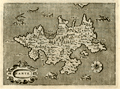 | Details | Porcacchi, Tomasso | 1572 |
| Greek Island of Zakynthos or Zante in the Ionian Sea |
|
Porcacchi, Tomasso |
|
| 1572 |
| LOC:2 |
| $175.00 | Porcacchi--Tomasso | Greek-Island-of-Zakynthos-or-Zante-in-the-Ionian-Sea | Copperplate-engraved antique map (1576), engraved by Girolamo Porro and drawn by Tomasso Porcacchi, of the Greek Ionian island of Zante or Zakynthos, the third largest of the Ionian Islands. A few of the key features Porcacchi notes on this old map of Zakynthos are: Plomati, Ambello, Zero Castelli, la Madonna, Santa Maria de Piscopo, and a large saline or salt marsh in a large bay to the north. Fantastical sea serpents fill empty areas in the finely stippled seas.
<br></br>
On a full page with text on recto and verso. Woodcut capital letter "I" at the beginning of the textual desription of Zante, in Italian, just below the map. Woodcut headpiece and a scrollwork title cartouche with simply "Zante".
<br></br>
Printed in Tomasso Porcacchi's "Isolario" or island book "L'Isol Piu Famose Del Mondo". That work contains a number of finely engraved maps of islands and the continents at a reduced scale. Porcacchi (1530-1585) was born in Tuscany to a poor family and first settled in Florence. He wrote about history, geography, and archaeology and later published the Isolario from Venice, Italy in three editions beginning in 1572. Page 98. |
| 906 |  | Details | Bordone, Benedetto | 1534 |
| Very early Balearic Island charts with Ibiza and Majorca |
|
Bordone, Benedetto |
|
| 1534 |
| LOC:4 |
| $1,250.00 | Bordone--Benedetto | Very-early-Balearic-Island-charts-with-Ibiza-and-Majorca | Two of the earliest obtainable maps of Spain's Balearic Islands: Majorca / Mallorca, Minorca / Menorca, Ibiza / Eivissa, and Formentera. A single sheet containing two antique woodcut maps (one map on each side). Published from Venice in 1534 in the second edition of Benedetto di Bordone's 'Isolario', or "Island Book". The Isolario provided nautical-chart inspired maps of islands alongside information for travellers on their culture, myths, climate, and history.
<br></br>
Recto contains a map with a portion of the eastern coast of Spain, at that time part of the "Regno de Catelogna", with five un-named settlements near "C. Martino" (today a diving spot kown as Cabo de San Martin) that may include Gandia, Javea / Xàbia, or Alicante. Offshore of the coast are the Balearic islands of Ibiza ("Ieuiza") and Formentera ("Formentazia") with the smaller surrounding islets of Tagomago, "Famolaria" (Santa Eulalia ?), and "Dragoneza" in the vicinity of Illa Sa Conillera. The last may be a error on the part of Bordone as there is an island "Illa Sa Dragonera" but it is located off the coast of Mallorca in roughly the same relative location to the west of the island.
<br></br>
Verso contains a map with Majorca ("Maiorica") with "Porto Colobo" or the Bay of Palma, and Minorca ("Minorica") with " Porto Mao" or Port Mahon. Two islets shown are Illa de l'Aire ("Cabrera") and "Dragonera".
<br></br>
Bordone's directional symbols correspond to many of the Italian names for the principal Mediterranean winds including, [G]reco; a cross denoting East ; [S]irocco; [O]stro or South; [P]onente or West; and [M]aestro.
<br></br>
Bordone (1460-1531) was a Paduan cartographer, and an illustrator of manuscripts, best known for his 'Isolario' or book of islands. Bordone's work was only the second isolario ever printed, the first being that of Bartolommeo Dalli Sonneti published in 1485. Text in Italian. |
| 903 | 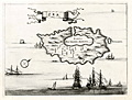 | Details | Dapper, Olfert (Olivier) | 1688 |
| Cycladic Greek Island of Kea |
|
Dapper, Olfert (Olivier) |
|
| 1688 |
| LOC:2 |
| $130.00 | Dapper--Olfert-(Olivier) | Cycladic-Greek-Island-of-Kea | Antique copper-plate engraved chart / plan of Kea ("Zea") or Tzia , an island in the Cyclades Archipelago of Greece, less than 40 miles from Athens. The attractive old map greatly overstates the size of the main port Korissia or "Porto per Grande Armata" relative to the rest of the island and understates the remaining area on the island to the west of the main settlement of Zea near the capital of Ioulis. Other areas noted by Dapper are the tiny island of "Scoglieto" and the "Fonte della Pazzia".
<br></br>
From Olfert Dapper's 1688 edition of his Descripion of the Mediterranean Islands or "Naukeurige beschryving der Eilanden, in de Archipel der Middelantsche Zee, en omtrent dezelve, gelegen: waer onder de voornaemste Cyprus, Rhodus, Kandien, Samos, Scio, Negroponte ...". Dapper was a Dutch writer and self-described physician best known for his books on Africa, China, Persia and Arabia.
<br></br>
Verso is blank. |
| 891 | 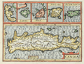 | Details | Jansson, Jan | 1630 |
| Antique map of Crete, Corfu, Zante, Milo, Naxos, Scarpanto |
|
Jansson, Jan |
|
| 1630 |
| LOC:2 |
| $315.00 | Jansson--Jan | Antique-map-of-Crete--Corfu--Zante--Milo--Naxos--Scarpanto | Antique map of several of the <b>Cycladic Greek islands</b> plus Corfu. A reduced-size copperplate engraving of Mercator's map of Crete ( "Candia" ) with inset maps above for the Greek isles of Corfu, Zante, Milos, Naxos ( "Nicsia" ), and Scarpanto.
<br></br<
Published 1630 by Jan Jansson from Amsterdam for Gerard Mercator's "Atlas Minor". Latin text on verso. |
| 851 | 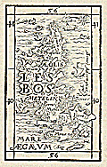 | Details | Munster, Sebastien | 1571 |
| Antique wood cut of the island of Lesbos, Greece |
|
Munster, Sebastien |
|
| 1571 |
| LOC:2 |
| $150.00 | Munster--Sebastien | Antique-wood-cut-of-the-island-of-Lesbos--Greece | Antique wood block printed map of the island of Lesbos ( Lesvos ), Greece in the northeastern Aegean Sea.
<br></br>
From "Strabonis rerum geographicarum libri septemdecim" authored by Sebastien Munster and published by Heinrich Petri. Map is inset in a 8"x11" full page of text, both in Greek and Latin. Text on verso. |
| 832 | 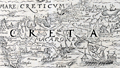 | Details | Munster, Sebastien | 1571 |
| Antique wood cut of the island of Crete, Greece |
|
Munster, Sebastien |
|
| 1571 |
| LOC:2 |
| $150.00 | Munster--Sebastien | Antique-wood-cut-of-the-island-of-Crete--Greece | Antique map of Crete ( "Creta" ), Greece in the southern Aegean Sea. In this decorative map from 1571 numerous towns are identified including Heraklion ( "Heraclea" ) , Chania ( "Candia" ), Rethymno ( "Rhithymna" ), and "Minoa". Crete was home to the Bronze age Minoan civilization. Today remains of the Minoan civilization are found across the island, particularly at the archaeological sites of Knossos, Phaistos, Malia, and Kato Zakros.
Several mountain chains and rivers are shown on this rare wood cut map of Crete. In the bottom right corner Munster has placed a large oared galley, with the Lion of St. Marks painted on its lateen sail, signifying Venice's rule over the island for more than four centuries.
<br></br>
From "Strabonis rerum geographicarum libri septemdecim" authored by Sebastien Munster and published by Heinrich Petri. Map is inset in a 8"x11"full page of text, both in Greek and Latin. Text on verso. |
| 825 | 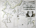 | Details | Collins, Greenvile | 1750 |
| Antique nautical chart of the Orkney Islands |
|
Collins, Greenvile |
|
| 1750 |
| LOC:57 |
| $550.00 | Collins--Greenvile | Antique-nautical-chart-of-the-Orkney-Islands | Antique sea chart of the North Sea, the Orkney Islands, Wide Firth, Hoy Sound and Deer Sound. The islands shown on this scarce, old British chart include parts of the Mainland ("Pomona"), Shapinsay, Gairsay, Wyre, Egilsay, and Rousay. With 5 coastal elevation views including: Copinsha to Mulhead; Faire Isle; the Maiden Papps of Carness; Dunkins Bay Head.
<br></br>
Title cartouche on this decorative chart of the Orkneys is held up by a pair of fierce sea eagles clutching a rag between their beaks. <div class="indenttextblock">Sea eagles have a long history in Orkney. The Bronze Age burial tomb at Isbister, South Ronaldsay (the ‘Tomb of the Eagles’) famously contains their bones, while a Pictish symbol stone found at the Knowe of Burrian, Harray, features a beautifully carved bird.
<br></br>
Sea eagles became extinct across the UK in the early 19th century due to combination of widespread habitat loss and human persecution, with the last bird shot in Shetland in 1918. (<b>Sea Eagles Nest in Orkney after 142-year Absence</b>". Royal Society for the Protection of Birds. <a href="http://www.rspb.org.uk/community/placestovisit/orkney/b/orkney-blog/archive/2015/04/16/sea-eagles-nest-in-orkney-after-142-year-absence.aspx">Internet.</a> June 19, 2015)</div>
</br>
Date in the title cartouche was largely erased from the copper engraving plate but remains faintly visible as 1688. This sheet is probably a later edition (estimated 1750), explaining the erasure. From one of the many editions of Greenville Collin's 'Great Britain's Coasting Pilot', published from 1693 to 1792. |
| 820 | 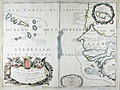 | Details | Coronelli, Vincenzo | 1692 |
| Antique map of Cape Verde Islands and West Africa |
|
Coronelli, Vincenzo |
|
| 1692 |
| LOC:54 |
| $650.00 | Coronelli--Vincenzo | Antique-map-of-Cape-Verde-Islands-and-West-Africa | Beautiful antique map of the Cape Verde Islands and West coast of Africa by cartographer and Franciscan monk Vicenzo Coronelli (1650 - 1718). The map was published from Venice in 1692 in Coronelli's atlas, the Atlante Veneto. Highly decorative title cartouche at bottom left with angels holding a large tapestry in front of a decorative garland. Inset of the African island of Goree at upper right corner. Goree was a trading post with some association to the Atlantic slave trade.
<br></br>
The Cape Verde islands were a stopping and revictualing location for numerous early explorers since their discovery by the Portuguese around 1456. In 1522 the famished crew of Ferdinand Magellan's ship Victoria, numbering about two dozen, stopped at the island of Santiago on their return from their record-setting circumnavigation of the earth. A bit more that 60 years later in 1585, Sir Francis Drake attacked and burned the town of Cidade Velha on the island of Santiago.
<br></br>
Seller's attribution at bottom left reads "Si vende presso Domenico Padoani sul ponte di Rialto all'Insegna della Geografia." Contains some soundings and marked anchorages but the intended use of the map was not for navigation but for general information and decoration. |
| 818 | 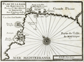 | Details | Michelot and Bremond | 1730 |
| Bay of Palma, on Mallorca, Spain (Balearics) |
|
Michelot and Bremond |
|
| 1730 |
| LOC:4 |
| $200.00 | Michelot-and-Bremond | Bay-of-Palma--on-Mallorca--Spain-(Balearics) | One of the first port plans of the Bay of Palma, Spain (1730) on the Balearic Island of Mallorca (Majorca) created for navigational purposes in an atlas for the Mediterranean Sea: “Recueil de Plusiers Plans des Ports et Rades de la Mer Mediterranee". The chart covers from Fort de Porto pin in the West to the far plains east of Palma ( "Palme") . Shows the region around Palama including fortifications, bastions, redoubts, gun batteries, and numerous windmills both to the east and west of the city. The Bay of Palma is referred to as the "Golfe de Mayorque".
<br></br>
This chart was published by the team of Henri Michelot and Laurens Bremond, both associated with the French Royal Galley Corps. In their business relationship it appears that Bremond provided the retail space in the port of Marseille, France where this chart, as well as other atlases and nautical prints were sold. Michelot, the chief pilot or "Pilote Hauturière" for the galley service provided the name recognition and authority needed for the charts to sell widely. |
| 800 |  | Details | British Admiralty Hydrographical Office | 1864 |
| Chart of South Sulawesi and Lesser Sunda Islands from Bali to Timor |
|
British Admiralty Hydrographical Office |
|
| 1864 |
| LOC:59 |
| $1,075.00 | British-Admiralty-Hydrographical-Office | Chart-of-South-Sulawesi-and-Lesser-Sunda-Islands-from-Bali-to-Timor | Antique British Admiralty navigational chart of a major portion of the Lesser Sunda Islands. Coverage includes the Strait of Macassar, Gulf of Boni, Banda Sea, Arafura Sea, the lower portion of Sulawesi, Indonesia ( Celebes ) , and the islands of Bali ( Baly ), Lombok, Sombawa, Comodo, Flores, and Timor. <br></br>
This fine large chart Includes 9 inset detailed charts at bottom left: Anapanam Bay, Laboaen Tring Bay, Pampang Bay, Pidioe Bay, Taliwang Bay, Bima Bay, Sapie Bay, Nangamessie Bay, Koepang Bay.
<br></br>
Published at the Hydrographic Office of the Admiralty August 4, 1851 with last corrections in 1864. Originally sold by J.D. Potter, London. Bottom margin includes a small pasted seller's label from Australia: "Blundell & Ford, Admiralty Chart Agents. Melbourne". Number 2073. |
| 792 | 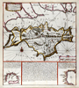 | Details | de Fer, Nicolas | 1692 |
| Isle of Wight, Solent, and South England |
|
de Fer, Nicolas |
|
| 1692 |
| LOC:89 |
| $400.00 | de-Fer--Nicolas | Isle-of-Wight--Solent--and-South-England | Antique nautical chart of the Isle of Wight, the Solent, and part of the south coast of Great Britain by French cartographer Nicolas de Fer. Published in 1692. Noted features of this attractive, colorful sea-chart include: Parkhurst Forest ("Wachinu Park"), the Golfe de Southampton, Pointe de Rames-head, Harve de Hamble, Harve de Rey, Presqu' Isle de Freshwater, Presque Isle de Binbridge, Banc de Mackett, and Spithead. Habitations shown include: Tirchfeild, Newchurch, Portsmouth, Gosport, Worth, Yarmouth, Newport, Helene, Nordwood, Yaverland, and St. Laurens Park. Two insets at bottom depict Tor Baye, and the Scilly Islands ("Isles Solrlingues").
<br></br>
The title cartouche carries the attribution: " A Paris Chez N. de Fer dans l'ile du Palais sur le Quaye de 'lOrloge a la Sphere Royale, aver Priv du Roy, 1692". Published from Paris, France by French geographer and cartographer, Nicolas de Fer (1646 - 1720). De Fer was a prolific producer of maps and prints who among other honors, was appointed as official geographer to the Spanish King in 1702. |
| 757 | 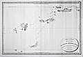 | Details | Beautemps-Beaupre, Charles-Francois | 1793 |
| Carte Generale de la Partie du Grand Archipel d'Asie |
|
Beautemps-Beaupre, Charles-Francois |
|
| 1793 |
| LOC:59 |
| $2,550.00 | Beautemps-Beaupre--Charles-Francois | Carte-Generale-de-la-Partie-du-Grand-Archipel-d-Asie | The Singapore Library web site sums up the significance of this scarce map of Asia: "Map of Indonesia showing tracks of Recherche and Esperance in 1792-1793. This map is part of the great archipelago of Asia, recognized by Rear Admiral Bruny-Dentrecasteaux, in 1792 and 1793" (1). This very scarce copper-plate engraved map is by Charles-François Beautemps-Beaupré (1766-1854). Charts by Beautemps-Beaupre are scarce. Only one other instance of this map is found in the AMPR.
<br></br>
On thick wove paper.
<br></br>
Chart of the waters and islands lying to the north of Australia including portions of the Ceram Sea, Arafura Sea, Banda Sea, and Molucca Sea, Key geographical features include a passage labeled "Dampier Strait", Waigeo ( Waigiou ), Batanta, Ceram, Ambon, Northern New Guinea, and Sulawesi ( Celebes ) and Timor. Much of the coastline of these islands is left blank because as of 1793 they were still uncharted and unexplored.
<br></br>
The map shows the track of two ships, the Recherche and Espérance , as they conducted an expedition (1791 - 1793) led by French Rear-Admiral Antoine Raymond Joseph de Bruni d'Entrecasteaux to find the missing ships of Jean-François de La Pérouse of whom nothing had been heard since March 1788.
<br></br>
C.F. Beautemps-Beaupre was one of the earliest hydrographers to use isobaths to represent water depth. Beautemp-Beaupres' many contributions to hydrography and his dedication to his profession is the reason he is sometimes referred to as the 'father of French hydrography'.
<br></br>
(1) Source online: http://eresources.nlb.gov.sg/printheritage/detail/61fb49ca-26e8-49cb-8e93-5f3558b123d2.aspx |
| 758 | 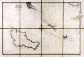 | Details | Depot de la Marine | 1908 |
| Antique nautical chart of Quiberon Bay with islands of Belle-Ile, Hoedic, and Houat |
|
Depot de la Marine |
|
| 1908 |
| LOC:66 |
| $425.00 | Depot-de-la-Marine | Antique-nautical-chart-of-Quiberon-Bay-with-islands-of-Belle-Ile--Hoedic--and-Houat | Antique lithographed chart of waters offshore of the west coast of France from southwest of the village of Saint Gildas and the Pointe du Grand-Mont. First published in 1826, this chart near the Brittany coast in western France includes the peninsula of Presqu'ile Quiberon and is the edition of January 1903 published with the latest updates in 1908.
<br></br>
Very extensive and minute detail of the shorelines and near shore areas with elevation denoted by fine hachuring. Thousands of soundings with isobath contour lines and navigational hazards would have aided the coastal navigator in the area. At the far right a particularly dangerous area for navigators, the "Plateau de la Recherche" is highlighted in brown
<br></br>
This is a early 20th century linen-mounted folding chart, an updated edition of a chart first published by France's Depot de la Marine in 1827. This lithographed nautical chart is based on the original surveys conducted during 1820 and 1821 under supervision of Charles-François Beautemps-Beaupré (1766-1854), considered to be the father of modern French hydrography. Beautemps-Beaupre was one of the earliest hydrographers to use isobaths to represent water depth.
<br></br>
Linen verso is printed via letterpress with "BELLE-ILE Entrée de la Baie de Quiberon. Iles Houat et Haedik". Number 135. |
| 733 | 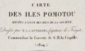 | Details | Duperrey, Louis-Isidore | 1824 |
| Chart of French Polynesia with Tahiti and Bora Bora |
|
Duperrey, Louis-Isidore |
|
| 1824 |
| LOC:59 |
| $575.00 | Duperrey--Louis-Isidore | Chart-of-French-Polynesia-with-Tahiti-and-Bora-Bora | Antique French hydrographic chart with the islands of Pomotou (Tuamotu Islands or French Polynesia). Other names include Archipel Dangereux, Archipel des Pomotou, Archipel des Tuamotu, Tuamotu Archipelago, Tuamotu Islands, and Îles Tuamotu. Includes the Society Islands ( Archipel de la Société ) of Tahiti ( Taiti ), Emeo, Huaheine, Bora Bora and many others and the Toubouai Islands.
<br></br>
Produced by French explorer Louis-Isidore Duperrey (1786-1865). Duperrey served as marine hydrologist to de Freycinet aboard the Uranie and commanded the corvette la Coquille on its westward world circumnavigation during the period 1822–1825 with Jules Dumont d'Urville as second in command. WorldCat only records one copy of this chart- at the Paris Museum National d'Histoire Naturelle.
<br></br>
Contains the tracks of many early voyages through the Pacific islands with dates of discovery for many islands. Discoverers include: Vancouver (1791), Carteret (1767), Bligh and Portlock (1792), Cook (1769), de Bougainville (1768), Lemaire and Schouten (1616) . Number 684. |
| 718 | 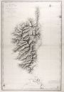 | Details | Blondeau, Alexandre | 1831 |
| Antique French Sea Chart of Corsica |
|
Blondeau, Alexandre |
|
| 1831 |
| LOC:66 |
| $850.00 | Blondeau--Alexandre | Antique-French-Sea-Chart-of-Corsica | Large antique copper-plate engraved nautical chart of the French island of Corsica ( Corse )and nearby islands: Isle of Asinara, Bonifacio Strait, Capraia Island, Elba ( Elbe ), and northern Sardinia ( Sardaigne ). Coverage includes the towns of Bonifacio, Ajaccio ( the birthplace of Napoleon Bonaparte ), Calvi, Ile Rousse, St Florent, Port Vecchio, and many more.
<br></br>
This splendid original French sea chart is a fine example of mid eighteenth-century nautical cartography. A heavy impression and admirable detailed engraving of the mountainous relief of the island are accompanied by a wealth of detail not only of the coastal regions but inland as well.
<br></br>
Issued by the French Depot Generale de la Marine in 1831 (dated within) after surveys by the Depot de la Guerre in 1824, and by Captain Hell in 1822, 1823, and 1824. Engraved by Alexandre Blondeau of France's Depot de la Guerre. At bottom right is the circular logo with anchor of the Depot General de la Marine. Number 232. Price when issued two Francs. |
| 687 | 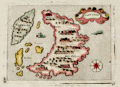 | Details | Porcacchi, Tomasso | 1686 |
| Antique map of Santorini, Greece |
|
Porcacchi, Tomasso |
|
| 1686 |
| LOC:2 |
| $300.00 | Porcacchi--Tomasso | Antique-map-of-Santorini--Greece | Old antique copperplate-engraved map of the Greek island of Santorini, Greece in the Aegean Sea. Noted points of interest include the islands of Aspronisi and Therasia, nearby Santorini, along with the Santorinan habitations of S. Salvador, Akrotiri ("Acortiri") , Scaro, and Nebrio. The colorful map was printed in 1686 in one of the last editions of Tomasso Porcacchi's "Isolario" or island book " L'Isol Piu Famose Del Mondo" which was first published in Venice ca. 1572. This 1686 edition is differentiated from earlier versions of Porcacchi's atlas in that 1) it is the only edition where the maps are not set within printed text, and 2) the chart was re-engraved for this edition and the compass rose is less elaborate.
<br></br>On the compass rose Porcacchi identifies eight points that correspond to the classical eight-point naming convention for Mediterranean winds that dates back at least 2000 years. The octagonal "Tower of the Winds" of the Roman Agora in Athens, Greece contains friezes on each wall depicting the principal wind deities and was once capped with a weathervane. Porcacchi's compass rose symbols "T", "G", "+" , "S", "O", "L", "P", "M", correspond to the Italian names for the principal Mediterranean winds: Tramontana ( North ), Greco, Levante ( with a cross denoting East ), Sirocco, Ostro ( South ), Libeccio. Ponente ( West ), and Maestro. ( Taylor, E.G.R., "The Haven Finding Art: A History of Navigation from Odysseus to Captain Cook". New York. 1957 (pp. 6-8)
<br></br>
Simple design as is common in the Isolario maps with depictions of two mythical sea monsters and a scrollwork title cartouche labeled simply: "Santorini". Seas are stippled
<br></br>
Ample margins and hand-coloring make this antique map of Santorini a fine candidate for framing. |
| 695 | 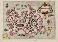 | Details | Porcacchi, Tomasso | 1686 |
| Antique map of Majorca, Balearic Islands, Spain |
|
Porcacchi, Tomasso |
|
| 1686 |
| LOC:4 |
| $325.00 | Porcacchi--Tomasso | Antique-map-of-Majorca--Balearic-Islands--Spain | Numerous fantastical sea monsters fill the empty spaces on this antique copperplate-engraved map of Majorca ( Mallorca ) , Spain the largest of the Balearic Islands. Majorca is nearly five times the size of its sister island Menorca. Majorca's history is closely tied to seafaring- the first people to colonize the island are believed to be Phoenician traders who arrived around the 8th century B.C.
<br></br>
This decorative old map was printed in 1686 in one of the last editions of Tomasso Porcacchi's "Isolario" or island book "L'Isol Piu Famose Del Mondo". This 1686 edition is differentiated from earlier versions in that: 1) it is the only edition where the maps are not set within printed text, and 2) the chart was re-engraved for this edition and the compass rose is less elaborate.
<br></br>On the compass rose Porcacchi identifies eight points that correspond to the classical eight-point naming convention for Mediterranean winds that dates back at least 2000 years. The octagonal "Tower of the Winds" of the Roman Agora in Athens, Greece contains friezes on each wall depicting the principal wind deities and was once capped with a weathervane. Porcacchi's compass rose symbols: "T", "G", "+" , "S", "O", "L", "P", "M", correspond to the Italian names for the principal Mediterranean winds: Tramontana ( North ), Greco, Levante ( with a cross denoting East ), Sirocco, Ostro ( South ), Libeccio. Ponente ( West ), and Maestro. ( Taylor, E.G.R., "The Haven Finding Art: A History of Navigation from Odysseus to Captain Cook". New York. 1957 (pp. 6-8)
<br></br>
Scrollwork title cartouche labeled simply: "Maiorica". Noted points of interest include islands of Cabrera and Dragonara, along with the Majorcan headlands of Capo Salime, P. Colombo, Monacur, Capo della Prea, Capo Formentar, Capo Baiol. Noted habitations include Maiorica ( Palma ), Cala Figera, Aliendia, Soller, Palomera, and Prementor.
<br></br>
Ample margins. Later attractive hand-coloring. |
| 672 |  | Details | Bellin, Jacques Nicolas | 1760 |
| Antique French Chart of the Caribbean Island of Grenada |
|
Bellin, Jacques Nicolas |
|
| 1760 |
| LOC:51 |
| $675.00 | Bellin--Jacques-Nicolas | Antique-French-Chart-of-the-Caribbean-Island-of-Grenada | Striking, original antique French sea chart of the Island of Grenada in the Caribbean Sea. Possibly the last official French chart of the island as Britain wrested Grenada from France in 1762 during the Seven Years' War. By J.N. Bellin of the French Depot de la Marine.
<br></br>
Coverage includes several of the smaller islands and islets in the Grenadine's chain: Carriacou, Round Island (Isle Rond), l'Islet de la Tante, Islet de Levera, Islet de Mileu, Islet de Haut. The chart is large and colorful and will display nicely.
<br></br>
Noted features of this large navigational chart include Cape David, Cape de la Grenade, Pointe de la Grande Riviere, Pointe du Fort Jendy, Pointe des Salines, Piton (peak) de Levera, Sauteurs, the Bourg du Grand Marquis, Victoria, Gouyave, and the town of St. George ( Fort Royal ). Soundings and anchorages are shown for the vicinity of St. George's.
<br></br>
Inset profile view of the approach to the north end of the island showing le Grison, l'Islet Rond, Islet de la Tante, la Pointe Percee, and Cape David. With the circular logo of the French Depot de la Marine. Attributed to Bellin and dated to 1760 in a decorative title cartouche. Price: trente sols. No. 82. |
| 1024 | 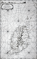 | Details | Bellin, Jacques Nicolas | 1760 |
| 1760 Nautical Chart of Grenada in the Caribbean Sea |
|
Bellin, Jacques Nicolas |
|
| 1760 |
| LOC:68 |
| $975.00 | Bellin--Jacques-Nicolas | 1760-Nautical-Chart-of-Grenada-in-the-Caribbean-Sea | Large antique French sea chart of the island of Grenada in the Carribbean Sea. Dated within the decorative title cartouche to 1760. Coverage includes several of the smaller islands and islets in the Grenadine's chain: Carriacou, Round Island (Isle Rond), l'Islet de la Tante, Islet de Levera, Islet de Mileu, Islet de Haut. By Jacques Bellin of the French Depot de la Marine.
<br></br>
This edition of Bellin's chart of Grenada lacks the circular logo of the Depot de la Marine at bottom right, the "No. 82" at top right, and the price. Contains an attractive inset elevation view of the approach to the north end of the island showing le Grison, l'Islet Rond, Islet de la Tante, la Pointe Percee, and Cape David.
<br></br>
Noted features of this large navigational chart include Cape David, Cape de la Grenade, Poine de la Grande Riviere, Pointe du Fort Jendy, Pointe des Salines, Piton (peak) de Levera, Sauteurs, the Bourg du Grand Marquis, Victoria, Gouyave, and the town of St. George ( Fort Royal ). Soundings and anchorages are shown for the vicinity of St. George's. |
| 656 |  | Details | Tassin, Christophe Nicholas | 1634 |
| Carte de l'Isle de Oleron |
|
Tassin, Christophe Nicholas |
|
| 1634 |
| LOC:4 |
| $160.00 | Tassin--Christophe-Nicholas | Carte-de-l-Isle-de-Oleron | Small, attractive map of the island of Oleron in the Bay of Biscay in Western France, just off the coast in the Atlantic Ocean. Oleron is France's second largest island, after Corsica.
<br></br>
Shows a great deal of interior detail as small as individual buildings, churches, windmills, and gardens. This map is a variant similar to but substantially different from the version published by Tassin in "Les Plans et profils de toutes les principales villes et lieux considerables de France" . This more scarce version contains a compass rose, the cartouche appears at bottom right, and the ships and interior island details are different.
<br></br>
Published by Tavernier in one of the many small-sized atlases created by Christophe Nicholas Tassin (d. 1660) . Tassin's background was as a military engineer, and he is best known for his nautical atlas of 30 sheets, dedicated to Richelieu, documenting France's coastline. Tassin's works contain topographic maps, often of militarily important sites, either sketched on site, composed from firsthand drawings by military engineers, or sometimes borrowed from other mapmakers. Plate 30. |
| 648 | 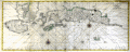 | Details | Valentijn, Francois | 1720 |
| Amboina, Seram, and Malaku Islands |
|
Valentijn, Francois |
|
| 1720 |
| LOC:0 |
| $880.00 | Valentijn--Francois | Amboina--Seram--and-Malaku-Islands | Scarce antique Dutch chart of part of the Maluku (Molucca) island chain in Indonesia (the Spice Islands). Includes Buru Island ( Boero ), Amboin, Seram (Ceram) , Banda, and many other smaller islands. The chart is comprised of two conjoined sheets making up the seldom available 29" wide chart of the region. On watermarked chain-laid paper.
<br></br>
From François Valentyn's Oud en Nieuw Oost Indien (Old and New East India), part V : Beschryving van Coromandel, Pegu, Arrakan, Bengale, Mocha, Persien, Malakka, Sumatra, Ceylon. François Valentijn (1666-1727) was a missionary who worked at Amboina from during the late 17th and early 18th centuries. With numerous rhumb lines and two compass roses topped with fleur-de-lis. Plate 1. |
| 626 | 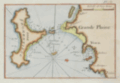 | Details | Roux, Joseph | 1764 |
| Ibiza and Formentera Spain |
|
Roux, Joseph |
|
| 1764 |
| LOC:4 |
| $190.00 | Roux--Joseph | Ibiza-and-Formentera-Spain | Antique engraved nautical chart of the harbor and town of Yvice ( Ibiza ) on the island of Ibiza, Spain. Coverage includes nearby Formentera ( Fromentiere ) Island.
<BR> </BR>
This small original chart is from the atlas of Mediterranean ports produced by Joseph Roux - "Recueil des Principaux Plans des Ports et Rades de la Mer Méditerranée".<BR> </BR>
There were at least four small atlases of port and coastal charts that originated from Marseille hydrographers in the 18th century. Beginning in approximately 1727 these atlases included works by cartographers
<a rel="nofollow" href= "/MichelotBremondBackground.aspx"> Michelot and Bremond</a>,
<a rel="nofollow" href= "/Creator/Ayrouard--Jacques"> Jacques Ayrouard</a>,
<a rel="nofollow" href= "/Creator/Roux--Joseph"> Joseph Roux</a>
, and Jean Allezard.
<br></br>
Comparison between Roux's chart and that of Michelot and Bremond shows that Roux copied Michelot's topography, anchorages, place names, and soundings directly from Michelot's chart that had been produced 40 years earlier. Plate 7. |
| 628 | 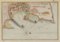 | Details | Roux, Joseph | 1764 |
| Antique chart of Rhodes, Greece |
|
Roux, Joseph |
|
| 1764 |
| LOC:2 |
| $185.00 | Roux--Joseph | Antique-chart-of-Rhodes--Greece | Antique nautical chart of the town and harbor of Rhodes on the island of Rhodes, Greece in the Aegean sea, close to the coast of Turkey.
<BR> </BR>
Original copperplate-engraved chart coverage by Joseph Roux includes the walled village of Rhodes, Casa Cornuta, and Rhodes harbor. The harbor and lighthouse, are shown as flanked by two jetties, each supporting a half-dozen windmills, and terminating offshore with a small fort or bastion. Numerous soundings and anchorages would have assisted 18th century mariners in navigating that area. <BR> </BR>
There were at least four small atlases of port and coastal charts that originated from Marseille hydrographers in the 18th century. Beginning in approximately 1727 these atlases included works by cartographers
<a rel="nofollow" href= "/MichelotBremondBackground.aspx"> Michelot and Bremond</a>,
<a rel="nofollow" href= "/Creator/Ayrouard--Jacques"> Jacques Ayrouard</a>,
<a rel="nofollow" href= "/Creator/Roux--Joseph"> Joseph Roux</a>
, and Jean Allezard. This small original chart is from the atlas of Mediterranean ports produced by Joseph Roux - "Recueil des Principaux Plans des Ports et Rades de la Mer Méditerranée". Plate 127. |
| 613 | 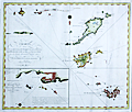 | Details | Fahlberg, Samuel | 1792 |
| Chart of Saint Barthelemy, St. Martin and Anguilla |
|
Fahlberg, Samuel |
|
| 1792 |
| LOC:51 |
| $22,500.00 | Fahlberg--Samuel | Chart-of-Saint-Barthelemy--St--Martin-and-Anguilla | Exceedingly rare original antique chart of the Caribbean islands of <b>Anguilla, St. Barts, St. Martin, Dog Island, and Prickly Pear Island</b> by Swedish cartographer and physician <b>Dr. Samuel Fahlberg</b> (1758-1834) . This beautifully engraved chart may well be the only available small-scale sea chart of these three Caribbean Islands by a Swedish cartographer.
<br></br>
No record of a sale of this chart in the Antique Map Price Record database (200K map sales since 1982). Faint pencil notations and a course plot into the harbor at Saint Martin indicate that this chart was used at sea. <br></br>
Fahlberg moved to St. Barthelemy (St. Barts / Barth) as a physician in 1784 after the island was ceded to Sweden by France. In 1803 Fahlberg was named Director of Survey of St. Barts; he thoroughly mapped the island for the Swedish West India Company ( Svenska Vastindiska Kompaniet ) <sup>1</sup>.
<br></br>
Contains a detailed inset of Gustavia on St. Barths titled "Speciale-Chart ofver Inloppet och Hammen Carenage samt Staden Gustavia. According to the John Carter Brown library: "The main town on Saint Barthélemy was called Le Carenage by the French, but renamed Gustavia by the Swedes when the island was given to the Swedes by Louis XVI in return for free port rights to Gothenburg, Sweden". A 'carenage' is an area typically along a shallow beach where wooden ships without access to a drydock could be beached at high tide, or careened, in order to clean, caulk, and repair their hulls.
<br></br>
On chain-laid paper with watermark: "C & I Honig". Engraved by the Swedish chart maker Erik Akerland (1754–1832). Stockholm: 1792. Text is in Swedish. <br></br>
<sup>1</sup> Reinhartz, Dennis. "The Caribbean Cartography of Samuel Fahlberg". History of Cartography Symposium. Springer. 2012. http://www.springer.com/978-3-642-19087-2. |
| 599 | 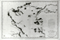 | Details | Depot de la Marine | 1827 |
| Northern Aegean Archipelago |
|
Depot de la Marine |
|
| 1827 |
| LOC:1403 |
| $1,750.00 | Depot-de-la-Marine | Northern-Aegean-Archipelago | Antique nautical chart of the coast and the islands of the northern Aegean Sea and the Sea of Marmara, including Constantinople, Turkey (modern Istanbul). Attractive old engraved chart documenting tracks of the exploration of that area. Extensive fine hachuring of coastal mountains, some soundings, and no interior details. At bottom of the inset 'avertissment' is found a legend dating each of the map's tracks to the year in which that exploration was conducted and identifying the abbreviations used by the authors for representing the composition of the sea bottom.
<br></br>
Geographical features covered by this antique chart include these locations in Greece and Turkey: Gulf of Corinth, Negroponte, Euboea ( the second largest Greek Island after Crete ), Skyros, Skiatos, Gulf of Salonica, the Dardanelles, Istanbul, Tenedos ( Bozcada ), Lemnos, Gulf of Smryne, Smyrne ( Smyrna ), Samos and much more.
<br></br>
An advertisement at right states that the chart is the result of hydrographic and geodesic work on land and aboard the gabare 'la Chevrette' during the years 1818 and 1819. <a href="https://fr.wikipedia.org/wiki/Gabare" target="_blank">A 'gabare'</a> is a French term for a three masted vessel of between 100 and 450 tons, typically used as a cargo carrier. Their heavy construction and capacity made them especially suitable for exploration and survey work.
<br></br>
Dated to 1827 at bottom of the oval cartouche. With the circular stamp of the Depot General de la Marine. Attribution reads: "Publiée par Ordre du Roi sous le Ministère de Son Excellence M. le Comte Chabrol de Crousol. Dépôt Générale de la Marine" Price when issued: two Francs. |
| 572 | 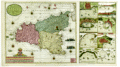 | Details | van Keulen, Gerard | 1724 |
| Sicilia |
|
van Keulen, Gerard |
|
| 1724 |
| LOC:0 |
| $4,000.00 | van-Keulen--Gerard | Sicilia | Extra-large, rare, original antique nautical chart of the island of Sicily, Italy. <strong>Two views of an erupting Mount Aetna ( Etna ) in Catania.</strong> Includes nine smaller harbor charts on the same sheet: Palermo, Trapani, Messina, Milazzo, Augusta, Catania, Agrigento and Siracusa. Unusually colorful and attractive specimen. Unusual to find this combination of large-scale and small-scale charts on a single page.
<br></br>
Inset at right in the sea shows two scenes related to the Battle of Cape Passaro, between Spanish and British naval forces on August 11, 1718 off the coast of Sicily. During the Battle of Cape Passaro, off the southeast coast of Sicily, forces led by British Admiral Sir George Byng aboard the flagship 'Barfleur' defeated Spanish naval forces led by Rear-Admiral Don Fernando Chacon.
<br></br>
By Gerard van Keulen, with the royal privilege, possibly from the third part of 'De Nieuwe Groote Lichtende Zee-Fakkel' published 1724. Near van Keulen's name is found the Coat of Arms of the Kingdom of Sicily with two facing eagles flanking the red stripes of the arms of the House of Aragon. |
| 575 |  | Details | Homann Heirs | 1762 |
| Antique chart of the Mediterranean featuring Sicily Sardinia Corsica Malta Gozo |
|
Homann Heirs |
|
| 1762 |
| LOC:50 |
| $650.00 | Homann-Heirs | Antique-chart-of-the-Mediterranean-featuring-Sicily-Sardinia-Corsica-Malta-Gozo | Decorative antique chart of the southern boot of Italy with the islands of <strong>Corsica</strong> ( Corse ) , <strong>Sardinia</strong> ( Sardegna or Sardegna ), <strong>Sicily</strong> ( Sicilia ), <strong>Malta</strong>, <strong>Gozo</strong> and much more to the Gulf of Tunis and northern coast of Africa (Barbaria). Based on the work of Rizzi Zannoni. Dated in the top title to 1762. A highly decorative title cartouche at bottom left of this antique map contains angels carrying state coats of arms above symbols of war including a warship firing a salvo from its starboard side.
<br></br>
Published by the firm <strong>Homann Heirs</strong>. Homann Heirs (also "Homannianis Heredibus" or "Homann Erben" or "Heritiers de Homann") was a company established after the death of German cartographer J.B. Homann to carry on the map publishing business of the firm he started in the early 1700's. The designation "Homann Heirs" appears on maps published by that successor firm from about 1730 to 1848. |
| 1005 |  | Details | Finn, W.J. | 1917 |
| Birdseye View of Boston Harbor by Union News Co. |
|
Finn, W.J. |
|
| 1917 |
| LOC:200 |
| $240.00 | Finn--W-J- | Birdseye-View-of-Boston-Harbor-by-Union-News-Co- | Folding antique colored harbor excursion map from ca. 1917 of South Boston, Boston Harbor, Dorchester Bay, Quincy Bay, and Cape Cod Bay to Provincetown. This colorful survivor shows steamship routes to coastal towns and identifies many nearby islands.
<br></br>
This map could have been purchased by passengers aboard any steamboat plying the routes shown on the map including:
<div class="indenttextblock">
<ul style="list-style-type: circle;">
<li>To Europe</li>
<li>To Provincetown</li>
<li>To Plymouth</li>
<li>To Nantasket</li>
<li>To New York</li>
</ul>
</div>
Legend at bottom identifies numerous islands and other features as a sample below illustrates:
<div class="indenttextblock">
<ul style="list-style-type: circle;">
<li>Nixes Mate</li>
<li>Snake Island</li>
<li>Commonwealth Pier</li>
<li>Minots Light</li>
<li>Rowes Wharf</li>
</ul>
</div>
Without the advertisements sometimes found on the cover. Price is noted on the front as "10 cents". |
| 540 |  | Details | Donnet, Alejo | 1831 |
| Cuenca, Valencia, Murcia, Baleares |
|
Donnet, Alejo |
|
| 1831 |
| LOC:0 |
| $550.00 | Donnet--Alejo | Cuenca--Valencia--Murcia--Baleares | Antique map of the Balearic Islands: Ibiza, Formentera, Mallorca ( Majorca ), Menorca ( Minorca ); the Mediterranean Sea, and the East coast and interior of Spain. Published by Dauty and sold by Simonneau from Paris ca. 1831. Title printed on the map reads: "Cuenca, Valencia, Murcia, Baleares". The map's source is Donnet's six-sheet "Mapa Civil y Militar de España y Portugal, con la nueva división en distritos."
<BR> </BR>
Large, attractive, well-kept, linen-backed folding map dissected into 18 sections of about 5.5 x 7.5 inches as issued. Maps the Balearic Islands and the East coast of Spain from Mar Menor near Cartagena north to Barcelona. Political regions and divisions are outlined in red. <BR> </BR>
Cover contains the seller's label in very fine condition that reads:<br>
"Magasin de Geographie de Charles Simonneau Graveur.
A Paris, Rue de la Paix, No. 6. Hotel Mirabeau vis-à-vis le Timbre. <br>
Cartes Geographiques et Topographiques Francaises et Etrangeres.<br>
Globes, Spheres, Atlas. Geographie, Ancienne et Moderne.<br>
(In manuscript): "Espagne (illegible) centrales."<BR> </BR>
Not dated but Charles Simonneau was a French engraver, map publisher, and map seller in Paris, France from approximately 1803 to 1838. Engraving is attributed as: "Grave par les Freres Malo, Rue du Gres No. 10. Pres la Sorbonne." Contains index tab at top of the map: "No. 4". |
| 536 | 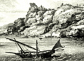 | Details | Choiseul-Gouffier, Marie Gabriel Florent Auguste | 1782 |
| Vue de la Cote de Santorin |
|
Choiseul-Gouffier, Marie Gabriel Florent Auguste |
|
| 1782 |
| LOC:9 |
| $180.00 | Choiseul-Gouffier--Marie-Gabriel-Florent-Auguste | Vue-de-la-Cote-de-Santorin | View of Santorini, Greece, an island in the Aegean Sea. Detailed and picturesque coastal view of villages and windmills perched above a rocky shore on the island of Santorini, Greece in the vicinity of the towns of Oia and Pyrgos. Engraved copperplate etching from the late 18th century. Engraved by J.B. Tilliard from the design by Choiseul-Gouffier.<br><br/>
From le Comte de Choiseul-Gouffier's "Voyage Pittoresque dans l'Empire Ottoman, en Grèce, dans la Troade, les îles de l'Archipel et sur les côtes de l'Asie-Mineure ". Printed before the French revolution with the royal license, "A.P.D.R." or "Avec Privilege Du Roi". Plate 16.<br><br/> |
| 537 |  | Details | Choiseul-Gouffier, Marie Gabriel Florent Auguste | 1782 |
| Plan du Golfe et des Isles de Santorin |
|
Choiseul-Gouffier, Marie Gabriel Florent Auguste |
|
| 1782 |
| LOC:9 |
| $325.00 | Choiseul-Gouffier--Marie-Gabriel-Florent-Auguste | Plan-du-Golfe-et-des-Isles-de-Santorin | Detailed antique map of the north-west coast of the Aegean island of Santorini Greece. Beautifully hachured relief shows offshore islands, villages, windmills, and fields above a rocky shore from the town of Oia (Apanomeria / San Nicolo) to about one French lieue south of the village of Pyrgos. Noted features include the Chateau de Scaro, Maison des Jesuites, and a small anchorage.<br><br/>
Finely engraved copperplate etching from the late 18th century. Engraved by J. Perrier from the survey laid down by F. Kauffer in 1776. <br><br/>
From le Comte de Choiseul-Gouffier's "Voyage Pittoresque dans l'Empire Ottoman, en Grèce, dans la Troade, les îles de l'Archipel et sur les côtes de l'Asie-Mineure ". Printed before the French revolution with the royal license, "A.P.D.R." or "Avec Privilege Du Roi". Plate 13. |
| 533 | 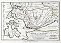 | Details | Bocage, J.D. Barbie du | 1799 |
| Greek Ionian islands of Lefkada, Ithaca and Cephalonia |
|
Bocage, J.D. Barbie du |
|
| 1799 |
| LOC:50 |
| $110.00 | Bocage--J-D--Barbie-du | Greek-Ionian-islands-of-Lefkada--Ithaca-and-Cephalonia | Map covers the Ionian Sea with the islands of Leucade (Lefkada), Ithaca and Cephalonia (Kefalonia) in Western Greece; the Gulf of Patras; and the Gulf of Corinth.
<br></br>
North of the three islands is depicted an area where two of the most well known sea battles of antiquity were conducted. Just off Preveza, Ottoman and Christian galley fleets engaged in one of the last major battles with large numbers of oared fighting vessels. Further inland, in the Ambracian Gulf, forces of Octavian clashed with those of Antony and Cleopatra at the Battle of Actium in 32 BC.
<br></br>
From Bocage's "Recueil de Cartes Geographiques Plans, Vues, et Medailles de l'Ancienne Grece, Relatifs au Voyage du Jeune Anacharsis." Dated to 1799 (Prairial An VI in the French revolutionary calendar). Number 26. |
| 530 | 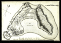 | Details | Jefferys, Thomas | 1761 |
| Plan of the Isle of Aix |
|
Jefferys, Thomas |
|
| 1761 |
| LOC:4 |
| $185.00 | Jefferys--Thomas | Plan-of-the-Isle-of-Aix | Plan of the island of Aix, France, off the mouth of the Charente river on the west coast of France. Depicts the village, vineyards, and fort, gun batteries, and a shipwreck at the northern end of the island. The plan shows the island as it existed after it was captured by the British in 1757 during the Seven Year's War.
<br><br/>
This plate is one of 80 maps included in Jeffery's "A Description of the Maritime Parts of France…" first published in 1761. |
| 524 | 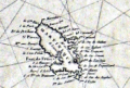 | Details | Depot de la Marine | 1806 |
| Carte Generale des Isles Antilles |
|
Depot de la Marine |
|
| 1806 |
| LOC:51 |
| $775.00 | Depot-de-la-Marine | Carte-Generale-des-Isles-Antilles | Large, rolled, copperplate engraved antique 'brown-back' working sea chart of the Caribbean (Antilles) issued by the French Depot de la Marine in 1806. Coverage includes from eastern Puerto Rico and its islands of Culebra and Vieques, the British Virgin Islands, Anguilla, St. Kitts, Nevis, Montserrat, Antigua, Barbuda, Guadeloupe, Dominica, Martinique, St. Lucia, St. Vincent, Grenada, Barbados, Trinidad and Tobago to the Venezuelan coast. The lower portion of the map covers the northern coast of Venezuela including the cities of Cumana and Barcelona. Numerous French place names, soundings and navigation hazards are noted.
<BR> </BR>
Chart is covered with brown linen; probably contemporary to its issue based on the wear pattern. Blueback charts, covered in blue linen, or heavy paper are much more common, These brown back charts are not often found. The linen has done a good job of protecting the map and maintaining it's fine condition over the last 200+ years.
<BR> </BR>
With the circular stamp of the French Depot de la Marine. No 187. Price 3 Francs. |
| 506 | 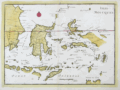 | Details | Le Rouge, George | 1767 |
| Isles Moluques |
|
Le Rouge, George |
|
| 1767 |
| LOC:6 |
| $185.00 | Le-Rouge--George | Isles-Moluques | Antique map of the Moluccas (Malaku Islands) in Asia, an archipelago within Indonesia. These islands were once referred to as the "Spice Islands". Plate 82. Coverage includes Bali, Borneo, Sulawesi (Celebes Isle) , East Java, Timor, Ambon, Ceram, and Western New Guinea. |
| 438 |  | Details | Blondela, Lieut. | 1797 |
| Vue du Mouillage des Fregates Francaises a L'Isle de Mowee |
|
Blondela, Lieut. |
|
| 1797 |
| LOC:59 |
| $450.00 | Blondela--Lieut- | Vue-du-Mouillage-des-Fregates-Francaises-a-L-Isle-de-Mowee | Engraved re-strike view of ships from the La Perouse expedition anchored off of Maui in the Hawaiian Islands at an anchorage now known as "La Perouse Bay". This is the first large-format view ever published of the island of Maui. From the "Atlas du Voyage de La Perouse". From a drawing by Lieutenant Blondela, Engraved by J.J. Avril; lettered by L. Aubert. No 14. <BR> </BR>
Believe the engraving is an early 20th century re-strike <b> from the original copper plate </b>produced by the Chalcographie du Louvre. La Chalcographie du Louvre is a repository of more that 13,000 original plates from the Louvre's archives, housed upstairs above the Louvre's Paris galleries . Upon request visitors can have a engraving produced from one of those original plates by master printers on museum-quality paper. V. 15<BR> </BR> |
| 419 | 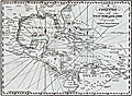 | Details | Malham, John | 1797 |
| A Correct Chart of the West India Islands engraved for Malham's Naval Gazetteer |
|
Malham, John |
|
| 1797 |
| LOC:3 |
| $375.00 | Malham--John | A-Correct-Chart-of-the-West-India-Islands-engraved-for-Malham-s-Naval-Gazetteer | Increasingly scarce on the market. Rev. John Malham's chart of the United States east coast lying south of Charlestown, South Carolina. Covers the Gulf of Mexico, Cuba, Bahamas, Hispaniola, the West Indies, Central America, Columbia, and Venezuela south to the mouth of the Orinoco River. This chart has examples of interesting usage of terms that are today known only from history books: 'Spanish Main' for the southern Caribbean Sea; 'Terra Firma' denotes northern Colombia and Venezuela. Key noted cities include Charleston, Savannah, St. Augustine, New Orleans, Havana, Port Royal, Cartagena, Caracas.
<br></br>
From the rare first American edition of Malham's Naval Gazetteer, published by Spotswood and Nancrede in Boston in 1797. Early U.S. colonial nautical chart engravings are scarce.
<BR> </BR>
This chart comes from an early nautical gazetteer or geographical dictionary produced first in England and after 1796 in the United States by John Malham a prolific Yorkshire-born author who produced other diverse works that include "Navigation Made Easy and Familiar". |
| 381 | 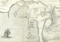 | Details | Anonymous | 1675 |
| Plan de la Ville de Rode |
|
Anonymous |
|
| 1675 |
| LOC:2 |
| $950.00 | Anonymous | Plan-de-la-Ville-de-Rode | Scarce engraving of the port of Rode (Rhodes), Greece decorated with a bat-form title cartouche, a square-rigged warship, and three galleys. References on the plan to the 'Grand Master' and 'Sultan Suleiman' suggest that the map was intended to illustrate the Siege of Rhodes in 1522 when the Knights of Rhodes were defeated and driven out by the Ottomans. That order later became known as the 'Knights of Malta' after they established residence on the island of Malta in 1530.
<BR> </BR>
We cannot locate an identical copy of this anonymous work anywhere on-line but the topographic details are nearly identical to those in a map by Dapper from 1687. This example probably dates from a period between 1650 - 1675 because this map contains more explanatory detail (in French) than Dapper's map and the strapwork cartouche points to an earlier style.<BR> </BR>
Numerous geographic descriptions include: the palace of the Grand Master; port des galeres; Tour de St. Jean; port des vaisseaux; the old walled village of Rhodes, and two long breakwaters, each protected by a tower at the end. Strapwork mileage scale. |
| 262 | 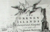 | Details | Mackenzie, Murdoch (Senior) | 1750 |
| Survey of the Orkney and Lewis Islands. (Atlas of 8 folio plates) |
|
Mackenzie, Murdoch (Senior) |
|
| 1750 |
| LOC:0 |
| $5,655.00 | Mackenzie--Murdoch-(Senior) | Survey-of-the-Orkney-and-Lewis-Islands--(Atlas-of-8-folio-plates) | This important, intact, and scarce folio-sized antique atlas of 8 plates is a landmark in cartography by Orkney native Murdoch Mackenzie Senior (1712 - 1797). This antique nautical atlas of the Orkney Islands, published in 1750 is Mackenzie's first published work and is considered to be the most accurate survey in Britain up to the mid 18th century. </br> </br>
<strong><a style="color:#9BAFCB" href= "/MackenzieAtlasViewer.aspx">[ Browse the entire atlas ]</a></strong> </br> </br>
In 1962 A.G.W. Robinson wrote about the unique characteristics of Mackenzie's first charts: "Some of the conventions he adopted, for example showing bottom deposits by a letter under the relevant sounding, are still in use on present day charts."
<br></br>
Contents include Title Page, Subscriber list, A 14 page History of the Orkneys, 8 charts of the Orkneys, Pomona, and the Lewis.
<br></br>
Reference: Robinson, A.H.W. 'Marine Cartography in Britain'. Leicester University Press. 1962. pp. 60-70. |
| 260 | 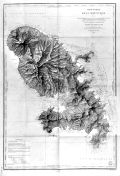 | Details | Monnier, Paul | 1893 |
| Carte Generale de la Martinique |
|
Monnier, Paul |
|
| 1893 |
| LOC:51 |
| $375.00 | Monnier--Paul | Carte-Generale-de-la-Martinique | Striking, antique sea chart / map of the island of Martinique, an overseas region of France, in the eastern Caribbean. This large chart is an 1877 edition of a chart first produced in 1831 by Monnier for France's Depot de la Marine, printed with corrections in 1893. . The chart is a fine example of the extensive use of hachuring to convey interior details of the island. <br></br>
Lighthouses dotted in yellow. Contains the circular seal for the Depot General de la Marine . |
| 819 | 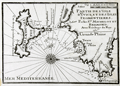 | Details | Michelot and Bremond | 1730 |
| Antique chart of the Balearic Islands of Ibiza and Formentera |
|
Michelot and Bremond |
|
| 1730 |
| LOC:4 |
| $200.00 | Michelot-and-Bremond | Antique-chart-of-the-Balearic-Islands-of-Ibiza-and-Formentera | Original engraved antique nautical chart of the Balearic islands of Ibiza and Formentera which now belong to an autonomous unit and province of Spain. The French chart, from 1730, shows the port and the town of Eivissa or Ibiza Town which is labeled "Yvice". Other noted points of interest include: Cap Saline, Porto Magno or Galache Fraques, Ile de Tagomago, and Ile Espalmador. Numerous soundings , anchorages, and rocks are noted as well as a water source near the village of St. Hilaire.
<BR> </BR>
This chart is one of 37 port plans published by <a style="color:#9BAFCB" rel="nofollow" href= "/MichelotBremondBackground.aspx">Henry Michelot and Laurens Bremond</a> ca. 1730 in their atlas of small scale Mediterranean ports: "Recueil de Plusieurs Plans de Ports et Rades de la Mer Mediterranée" . Both Michelot and Bremond were associated with the French Royal Galley Corps. In their business relationship it appears that Bremond provided the retail space in the port of Marseille, France where this chart, as well as other atlases and nautical prints were sold. Michelot, the chief pilot or "Pilote Hauturière" for the Corps des Galeres provided the name recognition and authority needed for the charts to sell widely. |
| 141 | 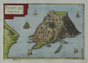 | Details | Tassin, Christophe Nicholas | 1636 |
| Fort de Brigancon |
|
Tassin, Christophe Nicholas |
|
| 1636 |
| LOC:4 |
| $195.00 | Tassin--Christophe-Nicholas | Fort-de-Brigancon | Scarce antique island map by Christophe N. Tassin from 1636. Depicts the Fort of Bregancon near Toulon which is the official retreat for the President of France. The island today looks very much the same as this copperplate engraved view created more than 360 years ago .
<br></br>
Published in the small-sized atlas "Les Plans et profils de toutes les principales villes et lieux considerables de France" by Christophe Nicholas Tassin (d. 1660) . Tassin's background was as a military engineer, and he is best known for his nautical atlas of 30 sheets, dedicated to Richelieu, documenting France's coastline. Tassin's work contains topographic maps, often of militarily important sites, either sketched on site, composed from firsthand drawings by military engineers, or sometimes borrowed from other mapmakers. |
| 118 |  | Details | Direccion Hidrografia | 1809 |
| Plano del Puerto del Alacran |
|
Direccion Hidrografia |
|
| 1809 |
| LOC:5 |
| $400.00 | Direccion-Hidrografia | Plano-del-Puerto-del-Alacran | Small, extremely rare, antique copperplate island chart from the Direccion Hidrografia, Spain's equivalent of the Depot de la Marine in France. This chart is one of 66 charts from the second volume of the work published in 1809: "Portulano de la America Setentrional Construido en la Direccion Detrabajos Hidrograficos. Antique Spanish sea charts of their New World possessions from this time period are not often found.<BR> </BR>
About 65 miles from the Yucatan coast of Mexico the Alacranes (Scorpion) reef was declared a Marine Protection Area in 1994. The chart includes numerous soundings along with the composition of the sands near the reef. Shows 4 small islands: Isla de Perez, La Lavendera, Isla Chica, and Isla de Pajaras. North oriented at the right of the chart. |
| 115 |  | Details | Thevet, Andre | 1575 |
| Palimbotre |
|
Thevet, Andre |
|
| 1575 |
| LOC:6 |
| $150.00 | Thevet--Andre | Palimbotre | Attractive antique woodblock engraving by Andre Thevet of a perhaps mythical island 'Palimbotre' that he places south of the Ganges River in the Bay of Bengal. About Palimbotre Thevet writes " in this island most of the inhabitants idolize and respect their idols which are made of decorous ebony, where their neighbors of the continent fashion them from marble, stone, sandalwood and other materials" (Conley, Tom. P. 195).<BR> </BR>
Thevet, born around 1516, became a Franciscan friar and wrote extensively about his travels in both the old world and new, widely embellishing the stories and images with myth and fiction. |
| 96 |  | Details | Coronelli, Vincenzo | 1691 |
| Isola e Castello di Gerbi |
|
Coronelli, Vincenzo |
|
| 1691 |
| LOC:8 |
| $325.00 | Coronelli--Vincenzo | Isola-e-Castello-di-Gerbi | A large antique sheet (13.5x19.5) from Coronelli's well known Isolario or Island Book with a map the island of Djerba off the north coast of Africa. With an inset of the Djerba Castle in upper right. <BR> </BR>
An interesting combination of styles, typefaces , and the broadsheet format makes this page by the famous Venetian cartographer a valuable addition to any collection at little cost. Copperplate engraving with Italian letterpress text below and on verso. Ornate capital letter "C". Page 301. |
| 97 |  | Details | Coronelli, Vincenzo | 1691 |
| Penon di Velez Isola della Goleta |
|
Coronelli, Vincenzo |
|
| 1691 |
| LOC:8 |
| $250.00 | Coronelli--Vincenzo | Penon-di-Velez-Isola-della-Goleta | A large antique sheet (13.5x19.5) from Coronelli's well known 'Isolario' or Island Book . Contains two engravings on opposing pages not backing on to the other. The engravings are nautical maps of two stronghold islands off the Moroccan and Tunisian coasts: Penon di Velez and Isola della Goleta. Italian letterpress text. |
| 81 |  | Details | Bellin, Jacques Nicolas | 1757 |
| Isles Britanniques, Troisieme Feuille |
|
Bellin, Jacques Nicolas |
|
| 1757 |
| LOC:0 |
| $500.00 | Bellin--Jacques-Nicolas | Isles-Britanniques--Troisieme-Feuille | Impressive antique copperplate nautical chart of Scotland (Edinburgh), Firth of Forth, Aberdeen, Dundee, Glasgow, Firth of Clyde, the Irish Sea and Northern Ireland (Londonderry) on very thick wove paper. Published by J.N. Bellin of the Depot de la Marine in 1757. The antique chart contains a large, decorative, dated title cartouche in upper right. Single vertical fold as issued. |
| 71 | 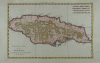 | Details | Bonne, Rigobert | 1780 |
| Carte de l'Isle de la Jamaique |
|
Bonne, Rigobert |
|
| 1780 |
| LOC:5 |
| $150.00 | Bonne--Rigobert | Carte-de-l-Isle-de-la-Jamaique | Attractive hand-colored antique chart by Bonne ca. 1780. Horizontal format of the island of Jamaica showing extensive mountain ranges. Spanish Town, Fort "Ahgusta", and Port Royal Harbor clearly identified. |
| 5274 |  | Details | Pepin, A. L. | 1931 |
| Map Plum Island Annie H. Brown Wild Life Sanctuary |
|
Pepin, A. L. |
|
| 1931 |
| LOC:10 |
| $550.00 | Pepin--A--L- | Map-Plum-Island-Annie-H--Brown-Wild-Life-Sanctuary | An unrecorded cyanotype (blueprint) map of Plum Island from 1931 related to early conservation efforts on the Massachusetts coast. The map shows the location of land purchased for the Annie H. Brown Wildlife Sanctuary and several adjacent properties proposed for purchase.
<br></br>
Plum Island is a New England barrier island that lies on the coast of Massachusetts about two miles from Newburyport, Mass. Plum Island, 11 miles in length, is named for the beach plum shrubs that grow in the dunes. The North Point of the island is located at the mouth of Newburyport Harbor, where the Atlantic Ocean meets the Merrimack River.
<br></br>
Legend at bottom describes seven numbered tracts of land on the map:
<div class="indenttextblocksingle">
<ul style="list-style-type: circle;">
<li>300 acres - Annie H. Brown Wildlife Sanctuary.</li>
<li>110 acres - Land of Knobbs Beach Associates.</li>
<li>225 acres - Land of Woodworth.</li>
<li>90 acres - Land of Stafford.</li>
<li>75 acres Land of Clement.</li>
<li>400 acres - Land of Bar Island realty Company.</li>
<li>3 acres - Land of Small.</li>
</ul>
</div>
Annie Hamilton Brown, a resident of Stoneham, willed a sum of between $15,000 and $25,000 to the Federation of the Bird Clubs of New England in 1929. Working with the Massachusetts Audubon Society, the federation was able to purchase most of the southern end of Plum Island for a wildlife sanctuary. In 1943, the Audubon Society sold the 1,600 acre sanctuary to the Federal Government who merged the land into the Parker River National Wildlife Refuge. This item includes the original fund-raising transmittal letter and return envelope from the Federation of the Bird Clubs of New England, Inc. Laurance B. Fletcher, Secretary; Boston, Massachusetts.
<br></br> |