| | Thumbnail | | Creator | Date | Title / Author / Date / Location | Price | | | Description |
| 3625 | 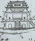 | Details | Churchill, Awnsham | 1744 |
| Earliest engraved view of Hanoi, Vietnam |
|
Churchill, Awnsham |
|
| 1744 |
| LOC:0 |
| $0.00 | Churchill--Awnsham | Earliest-engraved-view-of-Hanoi--Vietnam | SOLD<br></br>
A fine example of the earliest engraved view of Hanoi, Vietnam. |
| 4709 |  | Details | Baron, Samuel | 1744 |
| Earliest engraved view of Hanoi, Vietnam |
|
Baron, Samuel |
|
| 1744 |
| LOC:9 |
| $600.00 | Baron--Samuel | Earliest-engraved-view-of-Hanoi--Vietnam | A fine example of the earliest engraved view of Hanoi, Vietnam. Shows important buildings in Hanoi of the time identified in the key at center left: Sandy Bay, the King's Arsenal, the King's Elephant's Stables and the English and Dutch Factories. Contains interesting representations of indigenous rowed galleys of that era.
<br></br>
This antique view, "The City of Cha-Cho the Metropolis of Tonqueen", is a copper-plate etched print, by Samuel Baron. Baron published his account of mid-17th century Hanoi in 'A Description of the Kingdom of Tonqueen, by Samuel Baron, A Native Thereof'. Published from London in 1744 by Awnsham and John Churchill. Page 122.
<br></br>
In his description of the Kingdom of Tonqueen, Samuel Baron described the city of Hanoi (Ca-Cho) for a European audience, particularly with regard to its commercial potential.
<div class="indenttextblock">
"… the city of Ca-cho is the metropolis of Tonqueen, lieth in the latitude 21 degrees north, about 40 leagues from the sea, and may, for its capaciousness be compared with many cities in Asia, and superior to most for populousness, especially on the first and fifteenth of their new moon; being their market days or grand Bazaar; when the people from adjacent villages flock thither with their trade in such numbers as is almost incredible; several of the streets, tho' broad and spacious, are then so crowded that one finds enough to do if he can sometimes advance through the multitude a hundred paces in half an hour. </div><i>(Source: Online. https://books.google.com/books?id=BjvctNaIVAcC)</i> |
| 1085 | 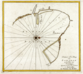 | Details | van Keulen, Johannes | 1753 |
| Scarce Dutch Chart of Phan Rang Bay, Vietnam |
|
van Keulen, Johannes |
|
| 1753 |
| LOC:6 |
| $350.00 | van-Keulen--Johannes | Scarce-Dutch-Chart-of-Phan-Rang-Bay--Vietnam | Scarce "secret" coastal chart of the Bay of Padaran ( vinh Phan Rang ) on the East Sea, north of Cape Padaran and just south of Cam Ranh Bay in Vietnam. Near the center of the chart a river, today's "Song Cai Phan Rang", empties into the bay. Located on the bay today is the city of Phan Rang–Tháp Chàm, also called Panduranga. Oriented with west at the top.
<br></br>
Keulen provides very little interior detail around this Vietnamese bay other than a few palm trees and some low mountains. The seas feature detailed hydrographic data, including depth soundings and the locations of sandbars and other navigation hazards. Two suggested anchorages are noted for VOC vessels, each for a specific wind direction: "Noorder Mouson" and "Zuyder Mouson".
<br></br>
From the sixth part of van Keulen's "<b>de Nieuwe Groote Lichtende Zee-Fakkel</b>" based on secret charts of the <b>Dutch East India Company</b> (Vereenigde Oost-Indische Compagnie or <b>VOC</b>). Prior to the mid-18th century these charts were only disseminated in manuscript to safeguard what the VOC considered to be proprietary trade secrets. The Dutch East India Company was the dominant trade force in Asia for nearly 200 years.
<br></br>
Bears the attribution at bottom: "By Joannes van Keulen". |
| 5306 | 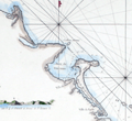 | Details | Mannevillette, d'Apres | 1775 |
| Rare French charts of Vietnam Coast including Da Nang |
|
Mannevillette, d'Apres |
|
| 1775 |
| LOC:9 |
| $475.00 | Mannevillette--d-Apres | Rare-French-charts-of-Vietnam-Coast-including-Da-Nang | Two original antique engraved charts on a single sheet: the Con Son Island Archipelago and Da Nang Bay including the Vietnam coast between the towns of Hue and Da Nang: "Plan de l'Isle Condor"; "Carte d'une Partie de la Cote de Cochinchine".
<br></br>
Includes three fine inset coastal elevation views:
<div class="indenttextblocksingle">
<ul style="list-style-type: circle;">
<li>Vue de l'Isle Champello ou Cham Collao.</li>
<li>Vue de l'entrée de la Baye de Touranne (Da Nang was known as Tourane during the French colonial period)</li>
<li>Vue de l'Isle Condor lorsque la Havre...</li>
</ul>
</div>
From J. B. d'Apres de Mannevillette's sea atlas "Le Neptune Oriental ou routier general des Cotes des Indes orientales et de la Chine." Jean-Baptiste d'Après de Mannevillette (1707 - 1780) was a French sailor, navigator, and hydrographer active in the mid-18th century. Mannevillette studied mathematics and navigation in Paris before winning a commission as an officer on a merchant vessel headed for the West Indies. Mannevillette collected and revised a number of regional nautical charts during numerous voyages around Africa to India and China.
The Compagnie des Indes (French East India Company) appointed D'Apres de Mannevillette as director of maps and plans at Lorient in 1752. |
| 6345 |  | Details | Roberts, Mike | 1966 |
| South Vietnam pictorial map mid-war era |
|
Roberts, Mike |
|
| 1966 |
| LOC:300 |
| $300.00 | Roberts--Mike | South-Vietnam-pictorial-map-mid-war-era | Fine pictorial poster-size map of South Vietnam. Created and published during the middle of the Vietnam War (1966) by Mike Roberts Color Productions. Map contains pictorial scenes of everyday life and of Vietnam War era aircraft and ships. Numerous inset photographs with scenes from simple Vietnamese everyday life, all in a format that suggests probable prior use as tourist-oriented postcards. (1)
<br></br>
Mike Roberts (1905-1989) was known as America's Postcard King. Roberts had a long career in color photography and printing that spanned more than 50 years. He became an important pioneer of Kodachrome postcards in the United States. (2)
<br></br>
Sources:<br />
(1) http://archiveswest.orbiscascade.org/ark:/80444/xv643950<br />
(2) https://www.huffpost.com/entry/wish-you-were-heremike-ro_b_7875752
<br></br>
[Fine pictorial map of Vietnam.] |