| | Thumbnail | | Creator | Date | Title / Author / Date / Location | Price | | | Description |
| 8090 |  | Details | Feher, Joseph | 1950 |
| The Dole Map of the Hawaiian Islands |
|
Feher, Joseph |
|
| 1950 |
| LOC:63 |
| $575.00 | Feher--Joseph | The-Dole-Map-of-the-Hawaiian-Islands | Original lithographed pictorial map of the Hawaiian Islands copyrighted by the Hawaiian Pineapple Company Ltd. 1950. Overall width 40.5 inches. Lacking original legend at right. Pinholes in margins.
<br><br>
Artist Joseph Feher depicted the Hawaiian islands and adjacent waters with boats, fish, and typical objects and pursuits associated with the islands: flying fish, surfing, spear fishing, sailing, poi-making, hula dancers, etc. Islands of the State of Hawaii mentioned in the legend include: Kauai, Niihau, Oahu, Molokai, Lanai, Maui, Kahoolawe, and the big island- Hawaii.
<br></br>
This is the second of two "Dole Pineapple Maps", the first was published in 1937.
<br></br>
Lithography by Schwabacher-Frey.
<br></br>
Once known as the Sandwich Islands, the Hawaiian Islands first documented discovery by a westerner occurred in 1778 with the arrival of British explorer Captain James Cook.
<br></br> |
| 8079 |  | Details | Sink, John | 1948 |
| Scarce pictorial map of western North Carolina |
|
Sink, John |
|
| 1948 |
| LOC:41 |
| $450.00 | Sink--John | Scarce-pictorial-map-of-western-North-Carolina | Western North Carolina: a vacationist's map and guide is a colorful mid-20th century pictorial map ca. 1948 illustrated by John Sink, a commercial artist known for lively regional tourist imagery. The map presents the Blue Ridge and Great Smoky Mountains as a continuous mountain chain extending from the Tennessee line eastward across western North Carolina ending at the Sauratown Mountains with Hanging Rock State Park.<br><br>
Peaks, gaps, and valleys are shown in bold, sculptural relief, while towns such as Asheville, Boone, and Bryson City anchor the geography. Cartoon figures hiking, skiing, fishing, and sightseeing animate the landscape, emphasizing recreation and leisure ("The Fun") rather than precise navigation.<br><br>
Designed as both a guide and a promotional image, the map combines expressive illustration with practical travel information. Major highways and scenic routes, including the Blue Ridge Parkway, trace the mountain ridges, while airplanes, automobiles, and roadside signage reflect the postwar rise of leisure travel by car and air. An inset conventional road map ("The Hiways") at lower right shows a detailed network of highways serving western North Carolina, reinforcing the sheet's function as both a souvenir image and a usable tourist guide.
<br><br>Text on verso with twelve proposed routes for scenic tours throughout the region. |
| 8036 |  | Details | Nadon, Paul and Sandi | 1985 |
| Colorful pictorial advertising poster of Seward, Alaska |
|
Nadon, Paul and Sandi |
|
| 1985 |
| LOC:130 |
| $325.00 | Nadon--Paul-and-Sandi | Colorful-pictorial-advertising-poster-of-Seward--Alaska | Colorful pictorial poster map of Seward, Alaska, drawn by Paul and Sandi Nadon and published by New Sensations in 1985. The sheet presents the harbor town of Seward on Resurrection Bay as a busy cartoon landscape, with streets, businesses, and waterfront activity rendered in bright hand drawn vignettes rather than formal cartography. A large vertical Seward banner along the left margin, smiling sun over the Kenai Mountains, and playful notes in the margins firmly place the map in the late twentieth century tourist boom along the Alaska coast.
<br><br>
Within the town grid the artists label motels, cafes, shops, churches, and civic buildings, while the surrounding hills show wildlife, waterfalls, and campgrounds. The harbor is packed with cruise boats, fishing vessels, sailboats, and float planes coming and going from Resurrection Bay, all keyed to short text panels that highlight local attractions such as the Silver Salmon Derby. A puffin shaped compass rose, orcas, sea otters, and seabirds enliven the water, and humorous scenes on land convey the easygoing character of Seward as a working port and visitor destination.
<br><br>
More than a simple street plan, the poster functions as an illustrated directory of mid-1980s Seward, preserving the look of its downtown businesses, harbor facilities, and tourist culture at a particular moment in time. The map should appeal to collectors of Alaska ephemera, pictorial map posters, and American roadside tourism, it is an engaging wall piece that rewards close inspection, with dozens of local references and comic details scattered across the sheet.
<br><br> |
| 8037 | 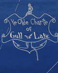 | Details | Conrad, Maynard | 1955 |
| Ye Olde Charte Of Gull Lake Kalamazoo County Michigan |
|
Conrad, Maynard |
|
| 1955 |
| LOC:130 |
| $375.00 | Conrad--Maynard | Ye-Olde-Charte-Of-Gull-Lake-Kalamazoo-County-Michigan | Mid twentieth century blueprint pictorial map of Gull Lake in Kalamazoo and Barry Counties, Michigan, with hand-drawn shorelines, compass rose, and whimsical period lettering. The sheet captures the resorts, parks, beaches, and cottages that once ringed this deep spring-fed lake north of Kalamazoo, documenting the area as a regional leisure destination. The artist, Dr. Maynard Conrad (d. 1998) uses simple white linework on blue background to present an engaging portrait of the lake at a time when summer colonies, canoe clubs, and motor launches were beginning to reshape the shoreline.
<br><br>
The map highlights a tight cluster of neighboring lakes that define the Gull Lake region. Little Long Lake and Miller's Lake appear to the northwest, while Grassy Lake is shown just beyond the isthmus that separates Gull Lake from its smaller companions. These lakes form part of a distinctive kettle-lake chain created by the region's glacial geography, a landscape that helped establish Gull Lake as one of the most celebrated inland waters of southwest Michigan. The sheet also notes well known features of the day, including Idlewild, Ross Township Park, Island Park, Crescent Beach, the Country Club grounds, and the string of cottages along Lover's Lane.
<br><br>
This pictorial blueprint serves equally as a regional souvenir and a record of community identity around Gull Lake. Resorts such as Bayberry Inn, Hickory Point, and Walnut Inn, together with family parks, bird sanctuaries, and boat landings, illustrate a thriving recreational culture. Surviving large format blueprints of local lakeside development are scarce, and this example offers collectors an attractive combination of graphic charm, local history, and early twentieth century Michigan cartographic style. |
| 8020 |  | Details | White Mountain Graphics | 1981 |
| Illustrated Pictorial Map of Martha’s Vineyard |
|
White Mountain Graphics |
|
| 1981 |
| LOC:130 |
| $300.00 | White-Mountain-Graphics | Illustrated-Pictorial-Map-of-Martha’s-Vineyard | A colorful illustrated poster map of Martha's Vineyard drawn by K. Rinaldo and published in 1981 by White Mountain Graphics. The poster is filled with hundreds of hand-drawn vignettes capturing island towns, harbors, beaches, landmarks, and summer pastimes. The artist uses a cartoonlike style to show ferries approaching Vineyard Haven, sailboats in Katama Bay, lighthouses, beaches, farms, and well-known establishments across Oak Bluffs, Edgartown, and Chilmark. Inset scenes, handwritten labels, humorous details, and decorative border elements give the sheet the character of a personal visual tour rather than a formal cartographic product.
<br><br>
The map functions as a record of Vineyard culture, highlighting cottages, inns, restaurants, bicycle routes, fishing spots, and community traditions that defined the island during the period. Its composition rewards close viewing, with dozens of local references rendered in a bright palette intended to evoke the island's summer energy. A striking pictorial map for collectors of Vineyard ephemera and American resort-town cartography.
<br><br>
White Mountain Graphics was a small New Hampshire-based illustration and design studio active primarily in the late 1970s and early 1980s. Operating out of Jackson, New Hampshire, the firm produced a range of commercially printed posters, pictorial maps, and souvenir-oriented visual materials, often in a hand-drawn style similar to the Martha's Vineyard map.
<br><br> |
| 7999 | 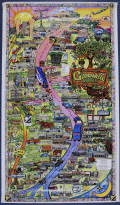 | Details | Landmark Adventures | 1992 |
| Greeville Avenue Dallas Texas Pictorial Map |
|
Landmark Adventures |
|
| 1992 |
| LOC:130 |
| $500.00 | Landmark-Adventures | Greeville-Avenue-Dallas-Texas-Pictorial-Map | This illustrated pictorial promotional poster map titled “Greenville Avenue: A Landmark Adventure – Dallas, Texas” depicts the full commercial corridor of Greenville Avenue using dense line-art drawings of individual businesses, landmarks, and street features. Drawn by Jack B. Weidner. Copyright Landmark Adventures, 1992-1993.
<br><br>The artwork organizes the avenue vertically, with north at the top, and identifies a large number of local establishments including restaurants, bars, boutiques, clubs, real-estate offices, and service businesses. Notable sites shown include the Doubletree Hotel, Old Town Shopping Center, Ada Art Gallery, Rollins, Corinthian Sailing Club, Pepe’s & Mito’s, The Diner, John’s Café, Flip’s, Nick’s Café, and many others. Corporate sponsors such as the Dallas Cowboys, Pepsi, Coors, RE/MAX, American Airlines, 94.5 The Edge, and Landmark Adventures appear within the composition, indicating commercial support at the time of publication. The map also includes playful vignettes—cars, pedestrians, musicians, hot-air balloons, aircraft, and neighborhood scenes—presented in a visually busy style meant to capture the character of the district.
<br><br>
Directional labels (Deep Ellum, McKinney Avenue), street names (Ross Avenue), and inset business directories help orient the viewer, while the border incorporates a decorative pattern consistent with late-20th-century pictorial map design. The poster functions as both a promotional guide and a snapshot of Greenville Avenue’s retail environment at the time it was created, documenting a concentration of independent businesses alongside well-known local institutions. As ephemera, it records the commercial identity of one of Dallas’s most recognizable streets and provides a detailed reference to storefronts and neighborhood culture that may no longer exist in the same form today. |
| 8000 | 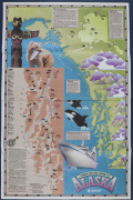 | Details | Exploration Cruise Lines | 1985 |
| Cool pictorial cruise poster of Alaska |
|
Exploration Cruise Lines |
|
| 1985 |
| LOC:130 |
| $365.00 | Exploration-Cruise-Lines | Cool-pictorial-cruise-poster-of-Alaska | Rare possibly unrecorded large format travel poster for Exploration Cruise Lines ca. 1985.
<br><br>
This promotional poster for Exploration Cruise Lines presents a stylized map of Alaska and the Pacific Northwest, built around the slogan “Nobody Gets You Closer to Alaska.” The map combines illustrated geographic features—such as Glacier Bay, Frederick Sound, the Gulf of Alaska, Yakutat Bay, and the Inside Passage—with small icons marking wildlife including bears, eagles, whales, seals, and mountain goats. Port calls and route segments are clearly labeled: Sitka, Juneau, Ketchikan, Wrangell, Petersburg, Seward, Prince Rupert, and other locations appear along color-coded itineraries for the Great Rivers Explorer and Pacific-Northwest Explorer. Insets summarize key regions (“Outside, the Inside Passage,” “Yakutat Bay,” “The Inside Passage and Beyond,” and “Alaska for the Independent Traveler”), highlighting landmarks such as Columbia Glacier, Hubbard Glacier, the Kenai Peninsula, Denali National Park, and the Misty Fiords National Monument.
<br><br>
The lower section features a large depiction of an Exploration Cruise Lines vessel entering Alaskan waters, together with the company’s name and sunburst logo. Text blocks emphasize the line’s focus on remote scenery, wildlife viewing, and smaller-ship access to narrow channels and glacial bays. A sidebar provides a simplified Inside Passage index and distances between ports, reinforcing the company’s claim of operating close-in routes not accessible to larger cruise ships. As a surviving piece of cruise-line ephemera from a short-lived 1980s operator, the poster documents how Exploration Cruise Lines marketed its Alaskan itineraries and presents a period design that blends infographic mapping with illustrative regional imagery. |
| 7995 |  | Details | Nadon, Paul | 1985 |
| Humorous pictorial map of Breckenridge, Colorado from 1985. |
|
Nadon, Paul |
|
| 1985 |
| LOC:130 |
| $450.00 | Nadon--Paul | Humorous-pictorial-map-of-Breckenridge--Colorado-from-1985- | This colorful pictorial poster map of Breckenridge, Colorado, created and signed by Paul Nadon, presents a detailed illustrated view of the town’s commercial core and surrounding mountain setting as it was in the mid-1980's. The drawing highlights Main Street and nearby blocks through individually rendered storefronts, lodges, restaurants, ski shops, and local businesses, each shown with distinctive architectural and graphic detail. The map functions as a stylized guide to the businesses of the period while offering a snapshot of Breckenridge during the mid-1980s. Copyright New Sensations, 1985.
<br><br>
Across the landscape, Nadon incorporates a wide variety of playful elements—skiers descending the slopes, hikers, wildlife, a hot-air balloon, a rainbow, and humorous scenes referencing local recreation. Hand-lettered notes provide bits of local history and commentary, while decorative banners and figures add to the informal, tourist-friendly tone of the piece. Despite the whimsical aesthetic, the arrangement of streets and buildings follows the real alignment of Main Street, Ridge Street, Park Avenue, and French Street.
<br><br>
Produced at a time when Breckenridge was expanding as a Rocky Mountain ski destination, the map captures the town’s commercial identity at a moment of growth. Its combination of detailed storefront depictions, vibrant illustrations, and personable local character makes it both a practical period guide and a visually engaging souvenir from 1980s Breckenridge.<br><br> |
| 6833 |  | Details | Van Ingen, Snyder, Gillett | 1876 |
| Pictorial Map of the International Exhibition Grounds First U.S. Worlds Fair |
|
Van Ingen, Snyder, Gillett |
|
| 1876 |
| LOC:86 |
| $975.00 | Van-Ingen--Snyder--Gillett | Pictorial-Map-of-the-International-Exhibition-Grounds-First-U-S--Worlds-Fair | Unrecorded variant edition "Pictorial Map of the International Exhibition Grounds", the first "World's Fair" held in the United States (1876) the same year the Statue of Liberty began construction in France. Along with the technological innovations and displays of American natural resources the Centennial Exhibition is notable as the location where two works of the renowned sculptor Frederic Auguste Bartholdi were on display- the right hand and torch of the Statue of Liberty and the Bartholdi Fountain.
<br><br>
<div class="indenttextblocksingle">
"In May of 1876, Bartholdi constructed the right arm bearing the torch, realizing it could stand alone if financing for the entire project failed. The torch’s display at the Centennial Exhibition in Philadelphia from August to November 1876 was a definite highlight with the fair’s approximately ten million visitors. Many scaled the 42-foot tall display for a fee of 50 cents."
</div><br> |
| 7957 | 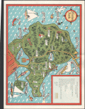 | Details | Page, Peter Hugh | 1941 |
| Rare third edition pictorial map of Stanley Park, Vancouver, British Columbia, Canada |
|
Page, Peter Hugh |
|
| 1941 |
| LOC:41 |
| $350.00 | Page--Peter-Hugh | Rare-third-edition-pictorial-map-of-Stanley-Park--Vancouver--British-Columbia--Canada | Beautiful lithographed pictorial map of Stanley Park, Vancouver, Canada by Peter Hugh Page, ca. 1941. Third Edition of three known editions by Peter Page. Shows Prospect Point, Brockton Point, Deadman's Island, Lost Lagoon, Second Beach, Beaver Lake and many other locations and attractions in Stanley Park.
<br><br>
<div align="center">
<a title="Stanley Park Cover"></a>
<img id="3" src="/ZoomifyImages/SC_6513/SC_6513_detail.jpg" alt="Cover from a brochure on Stanley Park, Vancouver, Canada by Peter Hugh Page in 1940." width="175"/> <br><small>Cover from Page's map of Stanley Park</small>
</div><br>
The third edition of Page's map of Stanley Park differs from the first and second editions in that it includes a label for Siwash Rock; the map shows, for the first time, the Illuminated Fountain built ca. 1936 in Lost Lagoon; and shows the Royal Vancouver Yacht Club site on Deadman's Island. Verso with text about Stanley Park. |
| 7934 | 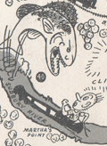 | Details | Ferran, Arch | 1947 |
| Humorous pictorial map of Concord, Massachusetts |
|
Ferran, Arch |
|
| 1947 |
| LOC:41 |
| $200.00 | Ferran--Arch | Humorous-pictorial-map-of-Concord--Massachusetts | This pictorial map of Concord, Massachusetts and Vicinity was created by Arch Ferran in 1947 and distributed as a complimentary map by the South Bridge Boat House, Inc. The design captures the charm of postwar New England tourism with stylized illustrations of landmarks, forests, and waterways surrounding Concord. The map celebrates both Concord’s rich Revolutionary War history and its literary heritage, presenting the town as a place of reflection, recreation, and natural beauty. Artistic vignettes of trees, bridges, canoes, and historic homes lend a storybook quality to the region’s geography.
<br><br>
The composition balances historic Concord’s landmarks—such as the Old North Bridge, the Minute Man Statue, and the Old Manse—with the scenic rivers and countryside that made the area famous among writers like Emerson and Thoreau. Roads radiate outward toward neighboring towns including Bedford, Carlisle, Sudbury, and Lincoln, creating a sense of exploration beyond Concord’s borders. The inclusion of small figures, animals, and recreational scenes reflects the local popularity of canoeing, hiking, and sightseeing, all centered on the South Bridge Boat House, a long-standing hub for outdoor activities on the Assabet and Sudbury Rivers.
<br><br>
At the upper right, the cartographer cleverly distinguishes True North and Magnetic North, acknowledging the map’s playful yet practical intent. The legend identifies key cultural and natural attractions, helping tourists locate historic homes, churches, and mills. Issued at a time when automobile tourism was flourishing, this map served both as a navigational aid and as a souvenir, capturing mid-century nostalgia for Concord’s enduring role in America’s founding and literary imagination.
<br><br> |
| 7893 | 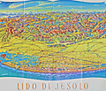 | Details | Oberbacher, Hans | 1958 |
| Lido di Jesolo beach near Venice Italy |
|
Oberbacher, Hans |
|
| 1958 |
| LOC:86 |
| $255.00 | Oberbacher--Hans | Lido-di-Jesolo-beach-near-Venice-Italy | Fine birds-eye view, "Lido di Jesolo", with Venice, Italy at the left. By Hans Oberbacher. 1958.
<br><br>
Lido di Jesolo, a popular seaside resort town, is situated within the metropolitan city of Venice, Italy. It is well known for its long sandy beach and vibrant nightlife, and it serves as a popular tourist destination, especially during the summer months. Lido di Jesolo is situated on the Adriatic coast close to Venice, making it a convenient location for visitors looking to enjoy both the beach and the historic city of Venice.
<br><br>
The region surrounding Jesolo has been featured in cartographic works dating back to the 14th century or earlier, crafted by renowned cartographers such as Pietro Vesconte, Fra Mauro, Benedetto Bordone, and Vincenzo Maria Coronelli, among others. These prior charts provide insight into the development of the Venetian Lagoon over time.
<br><br>
Jesolo has a history that dates back to ancient Roman times when it was known as Equilium, meaning "city of horses." The area was largely abandoned during the Middle Ages due to the decline of the Roman Empire and encroachment of the surrounding marshlands.
<br><br>
During the era of the Republic of Venice, which lasted from the 8th to the 18th century, the Venetians began to drain and reclaim the land for agriculture and fishing. The first settlements were established in the 19th century, and the town was renamed Cavazuccherina.
<br><br>
The opening of the first beach resort in 1911 marked the beginning of tourism in Lido di Jesolo. However, it was not until the post-World War II period that the town experienced a significant boom in tourism. During the 1950s and 1960s, rapid development and urbanization transformed Lido di Jesolo into one of the most popular seaside resorts in Italy. |
| 7899 |  | Details | Greenville Avenue Area Business Association | 1992 |
| Pictorial Advertising Map of Greenville Avenue Dallas Texas |
|
Greenville Avenue Area Business Association |
|
| 1992 |
| LOC:141 |
| $300.00 | Greenville-Avenue-Area-Business-Association | Pictorial-Advertising-Map-of-Greenville-Avenue-Dallas-Texas | Large advertising poster of Upper Greenville Avenue, a vibrant neighborhood located in east Dallas, Texas, known for its diverse restaurants, lively entertainment scene, and walkable streets. Situated along Greenville Avenue, the area is home to a wide variety of dining options, ranging from casual eateries to upscale restaurants, as well as live music venues, bars, and pubs.
<br><br>
The neighborhood is surrounded by residential areas, primarily composed of single-family homes and apartments. Upper Greenville also features a mix of local boutiques, vintage stores, and specialty shops, catering to various tastes and interests. The area hosts several annual events, such as the Greenville Avenue St. Patrick's Day Parade and Block Party, which attracts thousands of visitors.
<br><br>
Copyright 1992-1993 Landmark Adventures. |
| 7897 | 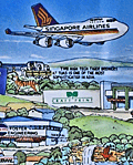 | Details | Rheault, Jean-Louis | 1990 |
| Pictorial advertising map of Singapore |
|
Rheault, Jean-Louis |
|
| 1990 |
| LOC:86 |
| $350.00 | Rheault--Jean-Louis | Pictorial-advertising-map-of-Singapore | Small pictorial advertising map of Singapore, emphasizing its muti-ethnic composition. Drawn by Jean-Louis Rheault. Copyright 1990. Singapore City Character Print produced by Descartes (Singapore), Tampines Street 93.
<br><br>
The map is filled with advertisements for local business, notable Singapore locations and facts about the city and its history including:
<div class="indenttextblocksingle">
<ul style="list-style-type: circle;">
<li>Singapore is the world's third largest oil refining center after Amsterdam and Houston.</li>
<li>October is the time of the pilgrimage to Kusu (turtle) island.</li>
<li>In the old days, Singapore River was home to Bugis traders and pirates from the Celebes who lived their entire lives on boats.</li>
<li>According to legend Sang Nila Utama, Prince of Palembang named Singa Pura, Sanskrit for Lion City.</li>
<li>Mandarin, Malay, Tamil, and English are Singapore's four official languages.</li>
<li>Just prior to the Japanese invasion Singapore was known as the "Gibraltar of the East."</li>
<li>General Yamashita invaded Singapore on Feb 2, 1952. The city was renamed Syonan.</li>
</ul>
</div> |
| 7877 | 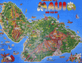 | Details | Island Funnies | 1990 |
| Cute Pictorial Map Poster of Maui, Hawaii |
|
Island Funnies |
|
| 1990 |
| LOC:130 |
| $195.00 | Island-Funnies | Cute-Pictorial-Map-Poster-of-Maui--Hawaii | <br><br>
Cute pictorial map poster of Maui, Hawaii by Island Funnies (1990) - licensee of Fiesta Cartoon Maps. The map highlights local parks and recreational activities including scuba diving, golf, fishing, sailing, and surfing.
<br><br>
Maui, the second-largest island in Hawaii, has a rich history dating back to ancient Polynesian settlers. The island was first settled by Polynesians who navigated the Pacific Ocean using the stars, arriving in Hawaii around 400-800 AD. These early settlers developed a complex society with a strict social hierarchy and a subsistence economy based on fishing and agriculture.
<br><br>
In the late 18th century, European explorers arrived in Hawaii, with Captain James Cook being the first recorded European to visit Maui in 1778. The island later became a center for the whaling industry and a popular port for ships traveling between North America and Asia.
<br><br>
Lahaina, located on the west coast of Maui, was once the capital of the Hawaiian Kingdom in the early 19th century. It was also a major whaling port and a center of commerce. Today, Lahaina is a popular tourist destination known for its historic buildings, art galleries, and restaurants.
<br><br>
Kapalua, situated on the northwest coast of Maui, was once a plantation growing pineapples and coffee. In the 1970s, the area was transformed into a resort destination featuring world-class golf courses, luxurious accommodations, and pristine beaches.
<br><br>
Haleakala, a massive shield volcano that forms the eastern portion of Maui, is a significant feature of the island. The volcano's crater is a popular destination for hiking, stargazing, and watching the sunrise. In 1916, Haleakala National Park was established to protect the unique volcanic landscape and the endemic species that inhabit the area.
<br><br> |
| 7884 |  | Details | Chase, Francis J. | 1959 |
| Pictorial Map of Alaska, the 49th State |
|
Chase, Francis J. |
|
| 1959 |
| LOC: |
| $295.00 | Chase--Francis-J- | Pictorial-Map-of-Alaska--the-49th-State | Ernest Dudley Chase's "A Pictorial Map of Alaska, the 49th State" is a fascinating visual representation of Alaska's history and its journey to statehood. The map, created in 1959, celebrates Alaska's admission to the Union as the 49th state on January 3 of the same year. Chase's signature style, combining attractive illustrations with geographical information, provides a unique perspective on this momentous event in American history.
<br><br>
The Chase's map incorporates an alphanumeric grid system to help users easily locate specific points of interest. Surprisingly, the map retains its original advertising sticker, prominently displayed in the upper left corner, bearing a price of 50 cents. The presence of the sticker serves as a testament to its authenticity, further enhancing its overall value and desirability.
<br><br>
The map showcases various aspects of Alaskan life, including its natural resources, industries, and cultural heritage. Chase depicts the state's diverse landscapes, from the rugged coastlines to the majestic mountain ranges, highlighting the beauty and vastness of America's last frontier.
<br><br>
Chase's map also chronicles the historical events leading up to Alaska's statehood, such as the purchase of Alaska from Russia in 1867, known as "Seward's Folly," and the discovery of gold in the late 19th century, which led to the Klondike Gold Rush. The map portrays the development of Alaska's major cities, including Anchorage, Fairbanks, and Juneau, as well as the growth of its industries, such as fishing, mining, and logging.
<br><br> |
| 6793 |  | Details | Nelson, Catherine and E. Theodore | 1944 |
| Pictorial, historical, advertising map of the Village of Flatlands in 1870 |
|
Nelson, Catherine and E. Theodore |
|
| 1944 |
| LOC:89 |
| $275.00 | Nelson--Catherine-and-E--Theodore | Pictorial--historical--advertising-map-of-the-Village-of-Flatlands-in-1870 | Fine historical pictorial promotional map of The Village of Flatlands, as it was in 1870 - compiled from "old and musty maps, records and surveys" by Catherine & Theodore Nelson. The map was commissioned, copyrighted, and published in 1944 by George L. Clark, Inc., "A complete real estate institution", 142 Avenue "U" Brooklyn, N.Y.
<br><br>
Rare. Only two copies recorded in WorldCat.
<br><br>
This historical map of Flatlands encompasses the area of Canarsie, extending eastward from Ocean Avenue to Fresh Creek and northward from Jamaica Bay to Hunters Fly Road. The map provides a detailed representation of the region, showcasing the names of various property owners, as well as the locations of important landmarks such as dams, hotels, schools, shops, public buildings, cemeteries, and churches. Additionally, the map also features the route of the Brooklyn and Rockaway Branch Railroad, which played a significant role in the development and connectivity of the area.
<br><br>
George L. Clark, Inc., formerly Clark Realty Co., is a family real estate firm founded in 1870 that spans five generations of Clarks. John J. Clark began the family business on Long Island in 1870. His son, Patrick L. Clark, relocated the business to Brooklyn in 1907. George L. Clark Sr. joined the family business in 1919 and served the Brooklyn community as a Realtor for 67 years. Clark was active on many New York real estate organizations and was President of the Brooklyn Board of Realtors, the Bay Ridge Real Estate Board and the Flatbush Real Estate Board.
<br><br> |
| 6868 |  | Details | Anonymous | 1940 |
| Pictorial Map Metropolitan Oakland California Pre-war |
|
Anonymous |
|
| 1940 |
| LOC:89 |
| $300.00 | Anonymous | Pictorial-Map-Metropolitan-Oakland-California-Pre-war | Scarce unattributed pictorial map of the metropolitan Oakland, California. Likely dates to circa 1940 based on the aircraft style in one of the photographic vignettes and the fact that the Oakland Bay Bridge, built 1936, appears on the map. Unsigned and undated. |
| 6863 |  | Details | Requa | 1947 |
| Very Rare Attractions Map of Florida |
|
Requa |
|
| 1947 |
| LOC:86 |
| $200.00 | Requa | Very-Rare-Attractions-Map-of-Florida | Fine lithographed pictorial map of Florida highlighting its numerous attractions and State Parks. Seems to be very scarce and generally unavailable.
<br><br>
Several of the attractions on the map have either been sold to developers, renamed, or closed. These include:
<div class="indenttextblocksingle">
<ul style="list-style-type: circle;">
<li>McKee's Jungle Gardens</li>
<li>Turner's Sunken Gardens</li>
<li>Ringling Art Museum</li>
<li>Marineland</li>
<li>Ravine Gardens</li>
<li>Oriental Gardens (closed in 1954)</li>
<li>Dupree Gardens</li>
<li>Everglades Reptile Gardens (now Everglades Wonder Gardens)</li>
</ul>
</div>
Lithographed and published by Macdonald Publishers of Tampa, Florida in 1947 two years before the establishment of the Florida Attractions Association (1949). |
| 6858 |  | Details | Graham County Arizona Chamber Commerce | 1940 |
| Pictorial Map of Gila Valley, Arizona |
|
Graham County Arizona Chamber Commerce |
|
| 1940 |
| LOC:89 |
| $315.00 | Graham-County-Arizona-Chamber-Commerce | Pictorial-Map-of-Gila-Valley--Arizona | Rare, humorous pictorial map of Gila Valley, Graham County, Arizona- The Valley of Smiles, circa 1940, drawn by artist Hal Empie. The map, on the verso of a folding brochure, shows pictograms reflecting Western culture all designed to attract visitors to the Gila Valley. At upper right the Gila Cliff Dwellings. Contains an interesting compass rose composed of Native American Indian Artifacts.
<br><br>
Towns included along Hwy. 70 as it follows the Gila River include: Bylas, Geronimo, Fort Thomas, Ashurst, Glenbar, Pima, Thatcher, and Safford, the seat for Graham County.
<br><br>
There were apparently two editions of this brochure, only one copy of the other (earlier ?) brochure with map was found online. No copy of this map or brochure found in WorldCat. |
| 6860 |  | Details | Anonymous | 1926 |
| Unrecorded Pictorial Map of Nevada and Calendar |
|
Anonymous |
|
| 1926 |
| LOC:89 |
| $350.00 | Anonymous | Unrecorded-Pictorial-Map-of-Nevada-and-Calendar | A very fine pictorial advertising map of Nevada from the Virginia City Bank of Virginia City, Nevada. With a complete calendar for 1926 at bottom. Includes unused metal hanger at top. A rare survivor in excellent condition. Map size 9.5" x 12.5". Overall, about 12" x 23".
<br><br>
<div id="0" align="center">
<a title=""></a>
<img id="6860" src="/ZoomifyImages/SC_6860/SC_6860_detail1.jpg" alt="Unrecorded Pictorial Map of Nevada with Calendar from 1926" width="240"/> <br><br> <font size="-2">1926 Virginia City Bank Advertising Map</font>
</div><br>
Virginia City, Nevada, was a historic mining town that experienced a significant boom in the mid-19th century due to the discovery of the Comstock Lode, a large deposit of silver ore. By 1926, however, the city had long passed its heyday and was in a state of decline. In 1926, the population was estimated to be around 1,500 people, a far cry from the 25,000 residents during the height of the mining boom.
<br><br>
In the early 20th century Virginia City began to shift its focus towards tourism. Efforts were made to embrace, preserve and promote the town's rich mining history and Wild West character to attract visitors. This map reflects that sentiment. |
| 6856 | 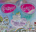 | Details | Blissberger, Linda | 1982 |
| Coconut Grove Poster Advertising Map |
|
Blissberger, Linda |
|
| 1982 |
| LOC:61 |
| $525.00 | Blissberger--Linda | Coconut-Grove-Poster-Advertising-Map | Scarce advertising poster map of Coconut Grove, Florida by artist Linda Blissberger. 1982.
<br><br>
"Designed by the Blissberger with the able assistance of the Bliss Bear while dodging bulldozers on Florida Ave. Jan. - Feb. '82. Blissberger Art & Airbrush Creations & Gallery of Surprises. 3425c Main Hwy. 445-3146." |
| 6835 | 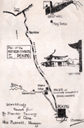 | Details | Yenching University Geology Department | 1927 |
| Rare Advertising Brochure Map of Peking for Sanitary Fur Company |
|
Yenching University Geology Department |
|
| 1927 |
| LOC:41 |
| $320.00 | Yenching-University-Geology-Department | Rare-Advertising-Brochure-Map-of-Peking-for-Sanitary-Fur-Company | Rare, unrecorded pictorial advertising map of Peking or Beijing, China prepared ca. 1927 for the Sanitary Fur Company by the Department of Geology and Geography at Yenching University. The maps are signed by George Barbour (1). Format: small tourist-oriented folding brochure.
<br><br>
The interior of the brochure shows a two-panel "Simplified Map of Peking". Back panel with a smaller-scale "Plan of the Northern Environs of Peking."
<br><br>
According to an inserted sheet found within:
<div class="indenttextblocksingle">
"The tanning of furs in China was started by Dr. H. S. Vincent, head of the Leather Department of Yenching University. This much needed step has popularized Chinese furs as the tanning makes them perfectly sanitary, all germs being killed in the process which also destroys the disagreeable smell so noticeable with Chinese furs imperfectly tanned."
</div><br>
<div id="SC_6835" align="center">
<a title=""></a>
<img id="6835" src="/ZoomifyImages/SC_6835/SC_6835_detail.jpg" alt="Advertisement for the Sanitary Fur Company. Peking China. 1927." width="300"/> <br><font size="-2">Advertisement for the Sanitary Fur Company. 1927.</font>
</div><br> |
| 6834 | 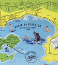 | Details | Melendez, Gilberto | 1955 |
| Fine mid-century pictorial map of Acapulco Mexico |
|
Melendez, Gilberto |
|
| 1955 |
| LOC:86 |
| $395.00 | Melendez--Gilberto | Fine-mid-century-pictorial-map-of-Acapulco-Mexico | Quite attractive touristic pictorial map of Acapulco Bay and surrounding areas. Inset map at top in a larger scale showing the road network between Acapulco and Mexico City. Additional inset map at right of Centro Downtown. Scarce.
<br><br>
Map contains an inset of the main advertiser, Hotel Caleta. Noted features include Isla la Roqueta, Puerto Marquez, el Patal Beach, Playa Suave, and many more. Inset tables identify local nightclubs and beaches. Produced by Gilberto Melendez. |
| 6832 |  | Details | Rentola, Esko | 1947 |
| Pictorial map of the Hood Canal Area |
|
Rentola, Esko |
|
| 1947 |
| LOC: |
| $700.00 | Rentola--Esko | Pictorial-map-of-the-Hood-Canal-Area | Rare pictorial map of the Hood Canal Area in Washington State by artist Esko Rentola. Rentola was closely associated with the Quilette Indian tribe and this map reflects this attachment.
<br><br>
Other maps by Rentola produced between 1957 and 1964 include Camano Island (1957), Forks Washington and Vicinity, West End Washington, and Grayland, North Cove, Tokeland, all approximately 13.5" x 17" in size.
<br><br>
Rare. None of Esko Rentola's maps, including this one, are referenced in WorldCat and only no reference to this map is found online. Dated to 1957 by comparison to the Camano Island map (online) with a similar float-line border and address. |
| 6811 |  | Details | Maury, Matthew Fontaine | 1956 |
| Matthew Maury's Whale Chart Third Ed |
|
Maury, Matthew Fontaine |
|
| 1956 |
| LOC:68 |
| $1,900.00 | Maury--Matthew-Fontaine | Matthew-Maury-s-Whale-Chart-Third-Ed | Rare world-wide thematic chart of reported whale sightings by Matthew Fontaine Maury. Provides data on whale sightings by season, geographic area, whale species, and relative frequency. First published in 1851 but this 3rd edition re-issued in 1956 by the U. S. Navy Hydrographic Office.
<br><br>
Maury's Whale Chart provided valuable information about the migratory patterns of various whale species based on data collected from whalers and merchant ships and depicted the seasonal movements of different whale species in the Atlantic and Pacific Oceans. It included information about the regions where whales were most commonly found during specific times of the year, helping whalers optimize their efforts and increase their chances of successful hunts.
<br><br>
The last three editions of Maury's Whale Chart may be identified thus:
<div class="indenttextblocksingle">
<ul style="list-style-type: circle;">
<li><b>Third Edition (1956)</b></br>
Upper top left position with logo of eagle clutching items in claws surrounded by text: "Hydrographic Office U.S. Navy". Top right position is blank. Bottom right position reads "Price 20 cents / H.O. Miscel. No. 8514".</li>
<li><b>Fourth edition (1960)</b></br>
Upper top left position with logo of eagle over an anchor surrounded by text: "United States Hydrographical Office". Top right position reads "Catalog: Introduction. Part 1.". Bottom right position reads "Price 50 cents / H.O. Miscel. No. 8514" .
</li>
<li><b>Fifth edition (after 1972)</b></br>
Upper top left with logo containing an eagle perched on a globe with text "Defense Mapping Agency". Top right position reads "Catalog P2V10". Bottom right reads "Lith of Wm. Endicott & Co. N. York | 5018 | DMA Stock Number | W0XZC5018.</li>
</ul>
</div> |
| 6797 | 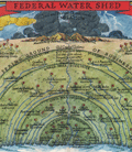 | Details | Appleton, LeRoy H. | 1935 |
| New Deal allegorical pictorial map Federal Water Shed |
|
Appleton, LeRoy H. |
|
| 1935 |
| LOC:89 |
| $225.00 | Appleton--LeRoy-H- | New-Deal-allegorical-pictorial-map-Federal-Water-Shed | A stunningly-executed allegorical persuasive map on the subject of the New Deal by LeRoy Appleton. The intent of the map was to argue against FDR's New Deal policies.
<br><br>
The New Deal was a series of economic programs and reforms implemented by President Franklin D. Roosevelt in the United States during the 1930s in response to the Great Depression. It aimed to provide relief, recovery, and reform to address the severe economic crisis and high unemployment rates of that time. It was implemented between 1933 and 1939.
<br><br>
Appleton uses water as a symbol to represent money, with rivers and wells as sources of that money later stored behind a dam, a symbol for the "reservoir of revenue."
<br><br>
Other allegorical imagery was used during that era to explain specific New Deal programs. For example, the symbol of the "Three Little Pigs" was employed to illustrate the different types of economic recovery measures. The first pig represented the ineffective, weak measures of the past, while the second pig symbolized temporary relief efforts. The third pig, who built his house with sturdy bricks, represented the New Deal programs that aimed to provide long-term economic stability and reform. By employing such storytelling devices, FDR and his administration aimed to create a sense of unity, hope, and support for the New Deal programs among the American people. Found in an issue of Fortune Magazine in 1935.<br> |
| 6794 |  | Details | Poisson, O. | 1950 |
| Fine mid-century lithographed pictorial map of Nice, France |
|
Poisson, O. |
|
| 1950 |
| LOC:89 |
| $165.00 | Poisson--O- | Fine-mid-century-lithographed-pictorial-map-of-Nice--France | Original, attractive, lithographed pictorial map of Nice, France by O. Poisson ca. 1950. Printed by Impremerie Bonfant & Rampelberg, Nice. Shows the Velodrome, Parc Chambrun, Conservatoire de Musique, Eglise Russe, Casino Municipal, and much more. Recto with German text about the city.
<br><br>
Located on the beautiful French Riviera, Nice is a captivating city that offers a unique blend of natural beauty, rich history, and vibrant culture. With its stunning coastline, palm-lined promenades, and crystal-clear waters, Nice is a paradise for beach lovers and outdoor enthusiasts. The iconic Promenade des Anglais, stretching along the azure waters of the Mediterranean, is a bustling hub where visitors can soak up the sun, enjoy leisurely walks, or indulge in delicious cuisine at the numerous beachside cafes and restaurants. Beyond the beaches, Nice boasts a charming Old Town with its narrow streets, colorful buildings, and lively markets, providing a glimpse into the city's rich heritage and offering a delightful blend of local shops, boutiques, and authentic French cuisine. |
| 6795 |  | Details | Delkin, James Ladd | 1944 |
| WWII-era Map of San Francisco, California |
|
Delkin, James Ladd |
|
| 1944 |
| LOC:89 |
| $195.00 | Delkin--James-Ladd | WWII-era-Map-of-San-Francisco--California | Original WWII-era street map of San Francisco, California with sketches of local life including a cable car, a machine-gun emplacement near the Golden Gate Bridge, and a sailor carrying a duffel bag. War housing projects scattered across the city are outlined in red. The map was originally attached within a small brochure published ca. 1944 by James Ladd Delkin: "All About San Francisco, Illustrated Map and Guide."
<br><br>
Verso with a map of Golden Gate Park and Panhandle by the San Francisco Board of Park Commissioners Division of Engineering and Landscape Design.
<br><br>
During World War II, San Francisco experienced significant changes in its housing landscape to accommodate the needs of the military. The city experienced a surge in population due to the influx of military personnel and defense workers, leading to a severe housing shortage. To address the housing shortage, the federal government, in collaboration with local authorities, initiated several public war housing projects. Projects highlighted in red on this map include:
<div class="indenttextblocksingle">
<ul style="list-style-type: circle;">
<li>Hunters Point Annex: The Hunters Point Annex, located in the southeastern part of San Francisco near the Hunters Point Naval Shipyard, was a housing development constructed for defense workers. It provided temporary housing during the war years.</li>
<li>Sunnydale Housing Development: Situated in the Visitacion Valley neighborhood of San Francisco.</li>
<li>Potrero Terrace and Annex: Built in the Potrero Hill neighborhood of San Francisco. </li>
<li>Oakdale</li>
<li>Candlestick Cove</li>
</ul>
</div> |
| 6787 | 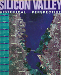 | Details | The Original Silicon Valley Map and Calendar | 1998 |
| Silicon Valley Historical Perspective Calendar Labeled Map |
|
The Original Silicon Valley Map and Calendar |
|
| 1998 |
| LOC: |
| $295.00 | The-Original-Silicon-Valley-Map-and-Calendar | Silicon-Valley-Historical-Perspective-Calendar-Labeled-Map | A sponsored calendar listing notable events for the 100 sponsoring firms in the Santa Clara Valley, Silicon Valley, California. Events range over a period from 1891 when Leland Stanford Jr. University opened near Palo Alto, through 1998 when Hexcel Corporation celebrated its 50th anniversary. Satellite photomap of Silicon Valley labeled with a numerical index sourced from the event table at right.
<br><br>
With large advertisement for the map's primary sponsor, Computer Literacy, that offered "computer and electronics books and related services to its customers through its retail stores and online."
<br><br>
Copyright 1997 by The Original Silicon Valley Map and Calendar a division of Amen International, San Jose California. Designed by OnTarget and printed by Benjamin Litho.
<br><br>
Other key events include:
<div class="indenttextblocksingle">
<ul style="list-style-type: circle;">
<li>1970 | Xerox Palo Alto Research Center is founded.</li>
<li>1976 | Wozniak and Jobs found Apple Computer.</li>
<li>1981 | IBM introduces the first IBM PC.</li>
<li>1987 | Microsoft PowerPoint introduced.</li>
<li>1995 | Sun Microsystems introduces Java.</li>
<li>1997 | Apple acquires Next with Steve Jobs.</li>
</ul>
</div> |
| 6784 |  | Details | Silicon Maps Inc. and Trestria Inc. | 2008 |
| 2008 Pictorial Calendar Map of Silicon Valley California |
|
Silicon Maps Inc. and Trestria Inc. |
|
| 2008 |
| LOC:11111 |
| $600.00 | Silicon-Maps-Inc--and-Trestria-Inc- | 2008-Pictorial-Calendar-Map-of-Silicon-Valley-California | Scarce "Classic Edition" Silicon Valley map and calendar copyrighted 2008 by Silicon Maps Inc. and Testria, Inc. Sponsored by Citrix, 4988 Great America Parkway, Santa Clara, California. Glossy finish as issued. |
| 6782 |  | Details | City Design | 1991 |
| Pictorial Advertising Map of San Jose, California |
|
City Design |
|
| 1991 |
| LOC:111111 |
| $1,600.00 | City-Design | Pictorial-Advertising-Map-of-San-Jose--California | Scarce pictorial advertising map of San Jose, California at the heart of Silicon Valley. A late 20th-century map produced and copyrighted by City Design of Pleasanton, California, in 1991. Names and phone numbers of sponsoring businesses appear in banners in the general vicinity of the business' address.
<br><br>
<div id="6782" align="center">
<a title=""></a>
<img id="6782" src="/ZoomifyImages/SC_6782/SC_6782_detail_1.jpg" alt="Detail from City Design map of San Jose, California. 1991." width="340"/> <br><br> <font size="-2">Detail from 1991 City Design map of San Jose, CA.</font>
</div><br> |
| 6760 |  | Details | Hillam, Corbin | 1981 |
| First Silicon Valley Advertising Pictorial Map |
|
Hillam, Corbin |
|
| 1981 |
| LOC:150 |
| $5,600.00 | Hillam--Corbin | First-Silicon-Valley-Advertising-Pictorial-Map | Original first pictorial advertising map locating "Silicon Valley". In 1981, artist Corbin Hillam unveiled a remarkable pictorial advertising map of Silicon Valley California, an artistic and commercial illustration that inspired a series of more than eighteen similar pictorial advertising maps created by various artists and publishers. Together the maps (1) provide an informative graphical time series of the firms active in Silicon Valley and the Santa Clara Valley Region in the late 20th century.
<br><br>
Analysis: The map is important as it is among the few remaining copies of Hillam's 1981 Silicon Valley map, created in the year IBM introduced its inaugural personal computer or PC, a groundbreaking event that sent ripples of innovation across the business landscape. IBM's PC served as a resounding testament, affirming the tangible reality of personal computing and establishing its enduring presence. 1981 was the year that personal computing won the corporate seal of approval.
<br><br>
Copyright Eclectibles, 1981.
<br><br>
<div id="6760" align="center">
<a title=""></a>
<img id="6760" src="/ZoomifyImages/SC_6760/SC_6760_detail_1.jpg" alt="First Silicon Valley Advertising Pictorial Map. Corbin Hillam. 1981. " width="340"/> <br><br> <font size="-2">Palo Alto detail from "Silicon Valley".</font>
</div><br><br> |
| 6780 | 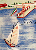 | Details | Ministero della Cultura Popolare | 1935 |
| Pictorial map of the province of Verona, Italy |
|
Ministero della Cultura Popolare |
|
| 1935 |
| LOC:400 |
| $395.00 | Ministero-della-Cultura-Popolare | Pictorial-map-of-the-province-of-Verona--Italy | An attractive lithographed touristic pictorial map of the Verona region of Italy on the verso of an 8-panel folding brochure for that region. Includes Lake Garda and Monte Baldo. Designed by F. Poggi and published ca. 1935 by Italy's Ministero della Cultura Popolare. Rare, no copy is found online.
<br><br>
The map shows images of duck hunters, skiers, swimmers, hikers, soldiers, and winemakers set on a background with local road and rail networks connecting Verona to the rest of Italy and Europe, especially to many nearby old cities. <br><br>
<div id="6780a" align="center">
<a title=""></a>
<img id="6780" src="/ZoomifyImages/SC_6780/SC_6780_detail_1.jpg" alt="Lake Garda detail from a pictorial map of the province of Verona, Italy" width="340"/> <br><br> <font size="-2">Lake Garda coastal boating detail.</font>
</div><br>
Recto with photographs of local attractions. Printed by Pizzi & Pizio - Milano-Roma. French text description at right.><br><br>
<div id="6780b" align="center">
<a title=""></a>
<img id="6780b" src="/ZoomifyImages/SC_6780/SC_6780_detail_2.jpg" alt="Lake Garda coastal and Monte Baldo detail from a pictorial map of the province of Verona, Italy." width="340"/> <br><br> <font size="-2">Lake Garda and Monte Baldo detail .</font>
</div><br> |
| 6775 |  | Details | Mikkelsen and Associates | 1991 |
| Silicon Valley Pictorial Advertising Map Spirit of Innovation |
|
Mikkelsen and Associates |
|
| 1991 |
| LOC:150 |
| $4,400.00 | Mikkelsen-and-Associates | Silicon-Valley-Pictorial-Advertising-Map-Spirit-of-Innovation | Pictorial map poster for Silicon Valley, California by Mikkelsen and Associates, 1991. The creator identifies San Jose as the "Capital of Silicon Valley." Very scarce in this version, lacking a calendar.
<br><br>
<div id="0" align="center">
<a title=""></a>
<img id="6775" src="/ZoomifyImages/SC_6775/SC_6775_detail_1.jpg" alt="Pictorial map poster for Silicon Valley, California by Mikkelsen and Associates, 1991" width="340"/> <br><br> <font size="-2"> Capital of Silicon Valley, San Jose, CA.</font>
</div><br>
The poster was commissioned and copyrighted by Access Global Inc. 1992 (1). With the San Francisco skyline visible at upper left, the poster map shows elevation views of local tech firm buildings and other businesses, each identified with the firm's name and logo. These include:
<br><br>
<div class="indenttextblocksingle">
<ul style="list-style-type: circle;">
<li>Mylex</li>
<li>Phase Two Industries</li>
<li>Synoptics</li>
<li>Hitachi Data Systems</li>
<li>Zilog</li>
<li>Sierra Semiconductor</li>
<li>Jabil Circuit</li>
<li>Photronics</li>
</ul>
</div>
(1) Access Global, Inc. Milpitas, California. Access Global, Inc. was incorporated in 1991. That firm's trademark was "Spirit of Innovation. |
| 6759 | 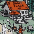 | Details | Clary, A. D. | |
| Pictorial map San Joaquin Power Club Wishon Cove Camp |
|
Clary, A. D. |
|
|
| LOC:89 |
| $250.00 | Clary--A--D- | Pictorial-map-San-Joaquin-Power-Club-Wishon-Cove-Camp | You have heard about "Where's Waldo?" but on this map I ask: "Where's Kilroy?"
<br><br>
An original post-WWII pictorial map of Wishon Cove Camp at Wishon Cove on Bass Lake in Crane Valley, California <b>featuring Kilroy</b> (1). Subtitled "San Joaquin Power Club", apparently this camp was originally a private club for the San Joaquin Power Company. Today the camp is run by the Pacific Service Employees Association.
<br><br>
The map shows hikers, horse-back riders, dancers, hunters, boaters, Boy Scouts, fishermen, and swimmers, all enjoying themselves outdoors on what appears to be some steep slopes. McDougald's store is located next to the shoreline and red-roofed Sam's Place seems to be the local watering hole, surrounded by apartments, dormitories, and numerous outhouses. The camp was named after businessman Arthur Wishon.
<br><br>
Arthur Emory Wishon, often known as A. Emory Wishon, was a pioneering figure in the development of hydroelectric power in California, using Bass Lake water. He served as a chief engineer and later as a vice president for San Joaquin Light and Power Corporation. His work significantly contributed to the construction of multiple dams and power plants in the region.
<br><br> |
| 6736 | 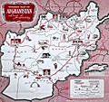 | Details | Information Bureau Royal Afghan Embassy London | 1960 |
| Rare Pictorial tourist map of Afghanistan |
|
Information Bureau Royal Afghan Embassy London |
|
| 1960 |
| LOC:54 |
| $475.00 | Information-Bureau-Royal-Afghan-Embassy-London | Rare-Pictorial-tourist-map-of-Afghanistan | A serious (not comical) pictorial map of Afghanistan published in the early 1960's by the Information Bureau of the Royal Afghan Embassy in London.
<br><br>
Rare, only one copy in WorldCat, at the University of Nebraska, Omaha.
<br><br>
Map focuses on mosques, livestock, and natural resources of Afghanistan. Boundaries of provinces delineated with dotted lines, and mountain passes shown by reversed brackets. Small inset map of Wakhan and Pamir. Scale 1:2,000,000. Roads with distances between major cities. |
| 6735 | 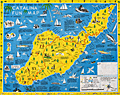 | Details | Ramsey, George | 1947 |
| Scarce pictorial fun map of Santa Catalina Island |
|
Ramsey, George |
|
| 1947 |
| LOC:89 |
| $295.00 | Ramsey--George | Scarce-pictorial-fun-map-of-Santa-Catalina-Island | <br><div class="indenttextblocksingle"><b>For a lasting remembrance of a grand vacation!</b> Keep this souvenir fun-map and mark the points you visit and the dates. Trace the routes of your travels on Catalina. Send copies to friends</div>
<br><br>
Where to go - What to see Santa Catalina Island fun map. A post-WWII pictorial map of Catalina Island, California. Copyright by George Ramsey. Published 1947 by Recreation Publishing Company, Los Angeles, CA. Price when issued 25 cents. Features include: Location of Ling-Ho Chinese junk movie set; Seal Rocks; submarine gardens; Chicago Cubs Ball Park and training grounds; the Catalina Visitors Country Club and much more.
<br><br>
Verso with map for Avalon Town |
| 6728 | 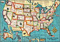 | Details | Anonymous | 1932 |
| Child's pencil box pictorial map United States |
|
Anonymous |
|
| 1932 |
| LOC:13 |
| $125.00 | Anonymous | Child-s-pencil-box-pictorial-map-United-States | Lithographed uncommon pictorial map ca. 1932 of the United States by the Joseph Dixon Crucible Company (DCC). Inset maps for the Philippine Islands, Alaska, Hawaiian Islands, Panama, and Porto Rico. Map interior is the standard cotton, cattle, and cactus and the seas are filled with the scene of a whaleboat capsized by its quarry, a fierce WWI-era battleship, a passenger liner, and a single-deck ship-of-the-line, possibly the Constitution. Following restoration that began in 1925, the Constitution sailed on a 90-port tour along United States' coasts by late 1931.
<br><br>
The DCC is also credited with the publication of Dixon's Mickey Mouse Map of the United States ca. 1936. That 10"x14" map was designed for inclusion in a set of child's pencils.
<br><br>
The Dixon Crucible Company was established by Joseph Dixon in Jersey City, NJ in 1847. Dixon (1799-1869) invented the Dixon Ticonderoga pencil, which was made by mixing graphite with clay and water and pressing it into grooved cedarwood. The company was taken over by Dixon's son-in-law, Orestes Cleveland, who established it as a highly regarded brand for mass production. The company suffered financial setbacks due to Cleveland's malfeasance, but it was saved by Edward F.C. Young and eventually came under the control of his son-in-law George T. Smith. The manufacturing complex was later converted into the Dixon Mills, a mixed-use apartment complex. In 2005, Dixon-Ticonderoga was acquired by the Italian-based FILA Group, a manufacturer in Mexico and China. |
| 6730 | 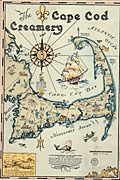 | Details | Gaffney, Walter M. | 1933 |
| Pictorial advertising map for the Cape Cod Creamery |
|
Gaffney, Walter M. |
|
| 1933 |
| LOC:13 |
| $550.00 | Gaffney--Walter-M- | Pictorial-advertising-map-for-the-Cape-Cod-Creamery | Historical pictorial map for Cape Cod Creamery ca. 1933 by Walter M. Gaffney. An unrecorded advertising piece for Cape Cod Creamery, associated with Noble's milk. On heavy card stock. Maps numerous historical and geographic locations including Pilgrim Monument, the Highland Light, Pleasant Bay, the Sandy Neck Light, the Cape Cod Canal. Scattered in each corner is a logo for Noble's milk, the map shows several delivery trucks labeled "Noble's that's good milk", and the large compass rose with a bottle of milk arranged at the center. Small piece of contiguous card stock apparently fashioned into a print hanger suggests the piece may have been trimmed into this shape by a previous owner.
<br><br>
Includes Buzzards Bay, Duxbury Bay, Provincetown Harbor, Wellfleet Harbor, Barnstable Harbor, Pleasant Bay, and a portion of Nantucket Sound.
<br><br>
<div class="indenttextblocksingle">
"Wellfleet or Whalefleet as it was originally called undoubtedly surpassed other towns. In 1843 a whale was captured near the end of the Cape and estimated to contain 200 barrels of oil and 2000 pounds of bone. Only 125 barrels of oil and 300 lbs. of bone were saved but with this waste it netted $10,000."
</div>
<br><br>
Gaffney is also credited with a larger pictorial map of Cap Cod 1932, in a different style, less historically oriented. |
| 6724 |  | Details | Perry, Heather "Herry" | 1930 |
| Rare Art Deco Imperial and International Communications Ltd Map Puzzle |
|
Perry, Heather "Herry" |
|
| 1930 |
| LOC:500 |
| $3,500.00 | Perry--Heather-"Herry" | Rare-Art-Deco-Imperial-and-International-Communications-Ltd-Map-Puzzle | <br></br>Bring a piece of British telecommunications history to your collection. This exquisite, complete, and rare Art Deco style puzzle map of the Imperial and International Communications (IICL) network ca. 1930 precedes McDonald Gill's Cable and Wireless Great Circle map by 15 years and features elegant characters representing the Anemoi, mythological Roman wind gods, and the Greek wind gods or Venti: Boreas, Zephyrus, Notus, Eurus, Aquilo, Favonius, Auster, and Vulturnus. Green lines indicate the undersea cables of the IICL, while dotted green lines signify IICL wireless transmissions.
<br><br>
<div id="0" align="center">
<a title="Perry's Telecom Map Puzzle"></a> <img id="3" src="/zoomifyimages/SC_6724/SC_6724_Detail.jpg" alt="Art Deco details from Herry Perry map puzzle for Imperial and International Communications Ltd, 1930, London." width="350"/> <br><small>Detail from Herry Perry's Art Deco IICL map puzzle, 1930.</small>
</div><br>
The map was designed by Herry Perry and manufactured as a promotional item for the IICL, by the Chad Valley Company, an eminent English toy manufacturer . The Chad Valley Company was active from 1860 to 1978. Its products ranged from high-quality soft toys, educational puzzles, board games, to construction sets.
<br></br>
In 1929, the Imperial Telegraphs Act paved the way for the formation of two new companies that would merge the various telegraph and wireless services within the British Empire and create a coordinated global communications network. Initially, IICL focused on expanding its services within the British Empire, but it eventually expanded its coverage to other regions like the Middle East, Africa, and Asia. IICL merged with Cable & Wireless Limited in 1934. Includes the intact original puzzle box.
<br><br>
Don't miss out on the opportunity to own a rare and remarkable piece of British telecommunications history - purchase this Art Deco map puzzle of the IICL network today. |
| 6716 | 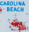 | Details | Greater Wilmington Chamber of Commerce | 1958 |
| New Hanover County Pictorial Fishing Map Mid century |
|
Greater Wilmington Chamber of Commerce |
|
| 1958 |
| LOC:86 |
| $175.00 | Greater-Wilmington-Chamber-of-Commerce | New-Hanover-County-Pictorial-Fishing-Map-Mid-century | Pictorial fishing map from 1958 of New Hanover County, NC. Drawn by Art Newton. Shows pictorially many locations for public fishing piers, surf fishing spots, wrecks, charter boats, boat launches and more. Soundings are provided near the beach and numerous inlets are identified including Carolina Beach Inlet, Masonboro Inlet, Moore Inlet, and Rich Inlet. Decorated with local fish: Flounder, Dolphin, Amberjack, Barracuda, Sailfish, and Bonito.
<br><br>
Copyrighted and published by the Greater Wilmington Chamber of Commerce, 1958. Printed by the Wilmington Printing Company, Wilmington, North Carolina.
<br><br> |
| 6705 |  | Details | John Player and Sons | 1938 |
| Unrecorded thematic pictorial tobacco advertising map |
|
John Player and Sons |
|
| 1938 |
| LOC:40 |
| $1,000.00 | John-Player-and-Sons | Unrecorded-thematic-pictorial-tobacco-advertising-map | Fine unrecorded advertising world map "Tobacco" published by John Player and Sons (1) circa 1938 (2). The map shows graphically the sources where tobacco was grown as well as shipping routes for tobacco cargos to England. Inset tables for: the four methods of curing tobacco; and the United Kingdom's principal sources of supply of different types of tobacco. Sketches at top and bottom of the map show the various steps in the growth, shipment, and preparation of Player's various tobacco products including cigarettes.
<br><br>
Not found in WorldCat. No example or record of a sale of the Tobacco map is found online.
<br><br> |
| 6702 |  | Details | Mathis, George | 1947 |
| Scarce pictorial map of the Feather River Basin |
|
Mathis, George |
|
| 1947 |
| LOC:87 |
| $325.00 | Mathis--George | Scarce-pictorial-map-of-the-Feather-River-Basin | A boomer-era 'cartogravure' of the Feather River Basin by George Mathis on the verso of a folding brochure for Gray Eagle Lodge in Blairsden, Plumas County, California. Dated within at 1955 in a hand-stamp on the recto. Coverage includes the Feather River, Long Lake, Gold Lake, Mud Lake, Smith Lake, Mt. Elwell, Frazier Falls, Mohawk Creek, Mills Peak and more.
<br><br>
The Feather River is a major river in Northern California, USA, with a length of about 71 miles. It is a tributary of the Sacramento River and is known for its scenic beauty, recreational opportunities, and historic significance.
<br><br>
During the California Gold Rush of the mid-19th century, the Feather River became an important source of gold. Miners used hydraulic mining techniques to extract gold from the riverbed, which caused significant environmental damage and siltation of the river. The discovery of gold in the Feather River contributed to the growth of several nearby towns, including Oroville and Marysville.
<br><br>
In the early 20th century, the Feather River became a focal point of water development projects aimed at supplying water to the growing population and agricultural needs of California. The Oroville Dam, completed in 1968, is the tallest dam in the United States and forms Lake Oroville, a major reservoir that stores water from the Feather River. |
| 6703 |  | Details | Prevoteau, Gerard | 1980 |
| Pictorial Map Aruba Pearl in the Caribbean |
|
Prevoteau, Gerard |
|
| 1980 |
| LOC:51 |
| $350.00 | Prevoteau--Gerard | Pictorial-Map-Aruba-Pearl-in-the-Caribbean | Very scarce out-of-print advertising-oriented pictorial map, circa 1980, of the island of Aruba in the Caribbean Sea. Illustrated by Gerard Prevoteau and published by Imprimerie Berger-Bellepage, Fort de France, Martinique (1). Prevoteau is known to have created more than thirty illustrations of towns and islands including Reims, the isle of Oleron, and a pair of maps or plans of the French town of St. Malo, France. Not in WorldCat.
<br><br>
Captions for many illustrations in either Dutch, English, or Spanish.
<br><br>
Aruba is a small Caribbean island located just off the coast of Venezuela. The island has a rich history, having been inhabited by indigenous tribes before being colonized by the Spanish in the 16th century. Today, Aruba is an autonomous territory of the Netherlands, and its culture is a unique blend of Dutch, Caribbean, and Latin American influences. Aruba is known for its beautiful beaches and also boasts a variety of outdoor activities, including snorkeling, scuba diving, hiking, and horseback riding. The island is also home to a number of historic landmarks and cultural attractions, including the California Lighthouse, the Arikok National Park, and the vibrant capital city of Oranjestad.
<br><br>
(1) Berger Bellepage company was created on August 1st, 1964, and it is one of the oldest printing companies in Martinique. The current printing facility has been located in Fort-de-France since 1969. |
| 6690 |  | Details | Weinstock, Howard | 1971 |
| Exuberant Pictorial Map of Florida |
|
Weinstock, Howard |
|
| 1971 |
| LOC:68 |
| $550.00 | Weinstock--Howard | Exuberant-Pictorial-Map-of-Florida | Exuberant Pictorial Map of Florida dated within at 1971. Designed and illustrated by Howard Weinstock. Copyright 1971 United States Map Company. Los Angeles, California.
<br><br>
<div id="0" align="center">
<a title=""></a>
<img id="6690" src="/ZoomifyImages/SC_6690/SC_6690_detail.jpg" alt="Details of the Florida Keys from the exuberant Pictorial Map of Florida by Weinstock dated within at 1971 " width="330"/> <br><br> <font size="-2">The Florida Keys</font>
</div><br>
<div id="0" align="center">
<a title=""></a>
<img id="6690" src="/ZoomifyImages/SC_6690/SC_6690_detail_1.jpg" alt="Gulf coast details from the exuberant Pictorial Map of Florida by Weinstock dated within at 1971 " width="330"/> <br><br> <font size="-2">Florida Gulf Coast</font>
</div><br>
<div id="0" align="center">
<a title=""></a>
<img id="6690" src="/ZoomifyImages/SC_6690/SC_6690_detail_2.jpg" alt="The Sun from the exuberant Pictorial Map of Florida by Weinstock dated within at 1971 " width="330"/> <br><br> <font size="-2">A happy Florida Sun</font>
</div><br> |
| 6685 |  | Details | Clarke, Dorothy Linscott | 1964 |
| Pictorial Map New Hampshire Coast |
|
Clarke, Dorothy Linscott |
|
| 1964 |
| LOC:68 |
| $950.00 | Clarke--Dorothy-Linscott | Pictorial-Map-New-Hampshire-Coast | Dorothy Linscott Clarke's desirable lithographed 1964 pictorial map of "New Hampshire's Famous Seacoast Region". Only 1 copy in WorldCat. Rare.
<br><br>
Unlike some artists' pictorial maps, Clarke doesn't attempt cheap humor or resort to demeaning stereotypes in her pictograms. The visual theme throughout could be described as old-fashioned Yankee Nautical as Clarke combines selected history and geography with nautical imagery to produce a map that reflects the nautical past and present of New Hampshire's Coast. Nautical symbols Clarke used include:
<div class="indenttextblocksingle">
<ul style="list-style-type: circle;">
<li>Anchor: The anchor is a symbol of stability, security, and hope. It represents the idea of being grounded and rooted, and being able to weather storms and challenges.</li>
<li>Ships wheel: The ship's wheel, also known as the helm, is a symbol of leadership, guidance, and control. It represents the idea of being able to steer a course through difficult waters.
<li>Whale: The whale is a symbol of strength, power, and the natural world. In maritime culture, whales were often seen as formidable creatures that commanded respect and awe.
<li>Sailor: The sailor is a symbol of adventure, courage, and freedom. Sailors were often seen as brave and resourceful individuals who were willing to venture out and face danger and uncertainty.</li>
<li>Rope: A rope can be seen as a symbol of connection, safety, or security, as it is often used to tie ships to docks or to other vessels.</li>
</ul>
</div>
Other pictorial maps by Dorothy Clarke include:
<div class="indenttextblocksingle">
<ul style="list-style-type: circle;">
<li>A map of Mother-Goose Land. 1933.</li>
<li>A map showing the locations of some of the houses at Strawberry Banke restoration at Portsmouth, N.H. 1965.</li>
<li>Historical picture map of Vermont, "The Green Mountain State." 1939.</li>
<li>A picture map of Noah's Ark for children. Circa 1930.</li>
</ul>
</div> |
| 6682 | 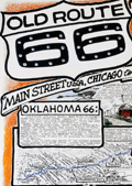 | Details | Waldmire, Robert | 1999 |
| Old Route 66 Pictorial Map Poster Chicago to L.A. 4th Final edition |
|
Waldmire, Robert |
|
| 1999 |
| LOC:300 |
| $140.00 | Waldmire--Robert | Old-Route-66-Pictorial-Map-Poster-Chicago-to-L-A--4th-Final-edition | The "Old Route 66 Main Street U.S.A. Chicago to L.A." poster created by Robert Wildmire is a highly detailed and intricate compilation of maps, historical facts, and drawings related to the famous Route 66 highway that stretches across the U.S. from Chicago to Los Angeles. Includes numerous inset illustrations and larger scale detailed road map fragments. A few of the more unusual locations on the poster, along Route 66 are:<br><br>
<div class="indenttextblocksingle">
<ul style="list-style-type: circle;"></li>
<li>The U-Drop Inn in Shamrock, Texas.</li>
<li>The Blue Swallow Motel in Tucumcari, New Mexico</li>
<li>The Cadillac Ranch, "just West of Amarillo".</li>
</ul>
</div>
First printing 5000 copies, of what Wildmire considered to be the "fourth and final incarnation" of the Route 66 map. According to a note on the poster,
<br><br>
<div class="indenttextblocksingle">"this color map originally appeared in National Parks Magazine (Mar. - Apr. '91). It was subsequently reprinted (in 2 editions, both out-of-print collectibles by now) by Dan Harlow of Rt. 66 Clothing & Goods, by arrangement with the artist."
</div>
<br>
Wildmire explains how this map differs from the three previous editions:<br><br>
<div class="indenttextblocksingle">
"I have added new color drawings & included my set of 8 "66 state postcard strip maps," showing each state's alignment in detail. I have added color to indicate the drivable through stretches (shown in blue) and those stretches on unavoidable Interstate (shown in red). "
</div>
<br>
<div id="0" align="center">
<a title="Baxter Springs"></a>
<img id="3" src="/ZoomifyImages/SC_6682/SC_6682_detail.jpg" alt="Baxter Springs, Kansas. Home of Ruth-anne and Lynn's Biker Bar." width="320"/> <br><small>Drill down view near Baxter Springs, Kansas.</small>
</div><br>
Printed by Frye-Williamson Press Springfield, Illinois Copyright 1999 |
| 6679 |  | Details | Glaubke, Bob | 1952 |
| Wild Bill Hickok Treasure Map pictorial thematic map |
|
Glaubke, Bob |
|
| 1952 |
| LOC:40 |
| $125.00 | Glaubke--Bob | Wild-Bill-Hickok-Treasure-Map-pictorial-thematic-map | 1950's pictorial thematic map, the "Wild Bill Hickok Treasure Map, of the United States, created by Bob Glaubke and published by Rand McNally in 1952. This map was a promotional item created by Rand McNally to advertise their line of maps and atlases.
<br><br>
The Wild Bill Hickok Treasure Map was a colorful and fanciful depiction of the American West, with illustrations of cowboys, Indians, and other Wild West icons. The map purported to show the locations of hidden treasures that were supposedly buried by the legendary gunslinger Wild Bill Hickok.
<br><br>
The Hickok map identifies numerous locations with some connection to mythical lost treasure including
<div class="indenttextblocksingle">
<ul style="list-style-type: circle;">
<li>Pensacola: Five large Spanish Treasure ships were wrecked...</li>
<li>Apalachicola: The pirate Billy Bowlegs ran his ship aground here...</li>
<li>Savannah: Th pirate John Hint is thought to have buried his treasure...</li>
<li>Murrell's Inlet: ...the pirate Murrell took shelter and buried treasure in the marshes here. </li>
</ul>
</div>
Wild Bill Hickok was a famous figure in the Old West, known for his prowess as a gunfighter and gambler. There are several legends surrounding him, including a supposed treasure map that he left behind. According to the legend, Hickok buried a treasure he won in a poker game, gold and other valuables, in the Black Hills of South Dakota before his death in 1876. He allegedly entrusted a treasure map to a friend, but the exact location of the treasure and the authenticity of the map are both widely disputed. |
| 6678 |  | Details | U.S. Coast Guard | 1972 |
| Coast Guard Poster worldwide locations |
|
U.S. Coast Guard |
|
| 1972 |
| LOC:86 |
| $145.00 | U-S--Coast-Guard | Coast-Guard-Poster-worldwide-locations | Decorative old-stock promotional poster ca. 1973 (1) with the locations of the U.S. Coast Guard around the world, or at least the western world. Executed with elements of 70's style reflecting the influence of the counter-culture on the arts during that period. With the Coast Guard motto : Semper Paratus or Always Ready.
The map omits any locations in Asia, where during that time period there was a war raging in Vietnam. Reminding the viewer of that overseas duty station was probably not conducive to the CG recruiting effort in '73.
<br><br>
Legend at bottom lists the activities and programs the U.S. Coast Guard engaged in including:
<div class="indenttextblocksingle">
<ul style="list-style-type: circle;">
<li>Icebreaking</li>
<li>Iceberg Patrol</li>
<li>Fisheries Conservation</li>
<li>Radio Navigation</li>
<li>Port Safety Vessel Traffic System</li>
<li>Search and Rescue</li>
<li>Aids to Navigation</li>
<li>Law Enforcement</li>
</ul>
</div>
(1) We have dated the map with reference to the planned Omega Station shown on the continent of Australia. Planning for that station was underway as early as 1972 when the Australian Department of Shipping and Transport was making a final site selection decision. The Omega Navigation System was a global radio navigation system that operated from 1971 to 1997. It consisted of eight ground-based stations, including three in Alaska, that transmitted signals in the VLF (Very Low Frequency) range to provide accurate navigation information for ships and aircraft. The Omega Navigation System was eventually replaced by more modern and precise satellite-based navigation systems such as GPS (Global Positioning System)
<br><br>
Document ID: G-PMR30 |
| 6677 |  | Details | Anonymous | 1936 |
| About and Roundabout Tucson pictorial map Arizona botanical interest |
|
Anonymous |
|
| 1936 |
| LOC:86 |
| $250.00 | Anonymous | About-and-Roundabout-Tucson-pictorial-map-Arizona-botanical-interest | Neat pictorial map of Tucson, Arizona, filled with historical facts and illustrated with simple sketches related to the city's long and colorful history. Bernice Walkley Porter, a Vassar graduate, is credited with creating a map "About and Roundabout Tucson" in 1936 (1). Though untitled, the map here is apparently Porter's and was issued as an folded untitled insert in a guide book by the same name that was published by the Junior League of Tucson in 1936. Verso with a road map of the state of Arionna.
<br><br>
During the 1930s, Bernice Walkley and Rutger Porter operated Desert Gardens Nursery on the same property as their small adobe house in Tucson. Rutger's love for desert plants earned him the nickname "Kactus Kid". Together Bernice and Rutger expanded their home and created the garden surrounding it. Over the years, their garden evolved into a beautiful oasis of winding walks, adobe walls, fountains, and greenery that reflected the sturdier choices for the Tucson climate.
<br><br>
The Porters closed their Desert Gardens Nursery in 1958. However, Bernice had a dream of turning their beloved property into a public garden, and donated it to the City of Tucson in 1968. By the early 1970s, the Tucson Botanical Gardens and the Porter property became a reality, with the City passing a resolution to develop the property into a horticultural center, sanctuary for wild birds, and a center for education. The Porter's adobe house now serves as the Gift Shop for the Tucson Botanical Garden
<br><br>
Many of the original plants from the Porter estate, including citrus, roses, privet, and jasmine, are still preserved in the Historical Garden, which represents the oasis style typical of large Tucson gardens dating from the 1920s to the mid-1960s.
<br><br>
(1) Griffin, Dori. Mapping Wonderlands: Illustrated Cartography of Arizona, 1912–1962. United States, University of Arizona Press, 2013. p. 192. |
| 6660 | 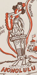 | Details | Mundorff, Ted | 1950 |
| Scarce pictorial map of Oahu, Hawaii |
|
Mundorff, Ted |
|
| 1950 |
| LOC:86 |
| $195.00 | Mundorff--Ted | Scarce-pictorial-map-of-Oahu--Hawaii | Scarce original pictorial map of Oahu, Hawaii by Ted Mundorff on light-ish weight paper. An insert road map from a book "Around Oahu with Moki: A trip around the Island of Oahu as seen through the versatile camera of Fred Maxwell." The map is annotated with location numbers keyed to Maxwell's book. Published by Maxwell from Honolulu in 1950.
<br><br>
Verso is blank.
<br><br>
Interesting cartoon-like drawings featuring cab driver Moki at bottom left lend a relaxed air to the prospective journey around Oahu including:
<div class="indenttextblocksingle">
<ul style="list-style-type: circle;">
<li>A hula-dancing rabbit on Rabbit Island.</li>
<li>Waialae Golf Club</li>
<li>A barber giving a shave at Barber's Point.</li>
<li>Healing stones</li>
<li>Manoa Valley</li>
<li>King Kamehameha</li>
<li>Schofield Barracks</li>
<li>Haleiwa and Kahuku</li>
</ul>
</div> |
| 6649 |  | Details | Perkins, T.C. | 1905 |
| 1905 Connecticut Valley Electric Transit Route Pictorial |
|
Perkins, T.C. |
|
| 1905 |
| LOC:41 |
| $250.00 | Perkins--T-C- | 1905-Connecticut-Valley-Electric-Transit-Route-Pictorial | Birds'-eye view pictorial map of the Connecticut Valley, following the Connecticut River. Shows the Electric Transit Trolley Route from Hartford, Connecticut To Greenfield, Massachusetts. The route includes the towns of Hartford, Chicopee, Springfield, Holyoke, Greenfield, and Turner Falls with population centers shown pictorially in profile.
<br><br>
The Connecticut Valley Electric Transit Route was a trolley line that operated in the early 20th century, specifically from 1905 to 1926, in the Connecticut River Valley region of Massachusetts. The line was a part of the Springfield Street Railway Company, which was one of the largest electric streetcar systems in the United States at the time.
<br><br>
The Connecticut Valley Electric Transit Route ran from Springfield to Holyoke, Northampton, and Amherst, and it was an important transportation link for people living in those areas. The trolley line connected these towns and allowed for easy travel between them, which was especially important for college students attending schools in the region, such as Amherst College and Smith College.
<br><br>
Mount Tom is a mountain located in Holyoke, Massachusetts, in the Connecticut River Valley region. The mountain has an elevation of 1,202 feet (366 meters) and offers sweeping views of the surrounding area.
In the early 20th century, Mount Tom was a popular tourist destination, and it was a common stop on the Connecticut Valley Electric Transit Route. The trolley line had a station at the base of the mountain, and visitors could take a funicular railway up Mount Tom. Once at the top of Mount Tom, visitors could enjoy a range of activities, including hiking, picnicking, and even a zoo. The mountain was also home to a popular amusement park, which featured a roller coaster, a Ferris wheel, and other rides and attractions.
<br><br>Published by T.C. Perkins Hartford, Connecticut 1905. E.A. Sherman del. |
| 6643 |  | Details | White, Ruth Taylor | 1931 |
| Pictorial map of the Island of Oahu in Hawaii |
|
White, Ruth Taylor |
|
| 1931 |
| LOC:89 |
| $200.00 | White--Ruth-Taylor | Pictorial-map-of-the-Island-of-Oahu-in-Hawaii | Fine lithographed cartograph or pictorial map of the island of Oahu, Hawaii by Ruth Taylor White. In 1931 White produced four maps of individual islands for the Hawaii Tourist Bureau: Kauai, Maui, Hawaii, Oahu, and one map of the entire Hawaiian Island chain. Printed by the Honolulu Star-Bulletin.
<br><br>
Locations and features that White captured on her map of Oahu include:"
<div class="indenttextblocksingle">
<ul style="list-style-type: circle;"></li>
<li>Waimea Falls</li>
<li>Kaneohe Bay</li>
<li>Kailua Bay</li>
<li>Diamond Head</li>
<li>Waikiki Beach</li>
<li>Honolulu</li>
<li>Pearl Harbor</li>
<li>Koko Head</li>
</ul>
</div> |
| 6644 | 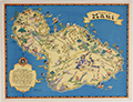 | Details | White, Ruth Taylor | 1931 |
| Pictorial map of the island of Maui in Hawaii |
|
White, Ruth Taylor |
|
| 1931 |
| LOC:89 |
| $250.00 | White--Ruth-Taylor | Pictorial-map-of-the-island-of-Maui-in-Hawaii | Fine lithographed cartograph or pictorial map of the island of Maui, Hawaii by Ruth Taylor White. In 1931 White produced four maps of individual islands for the Hawaii Tourist Bureau: Kauai, Maui, Hawaii, Oahu, and one map of the entire Hawaiian Island chain. Printed by the Honolulu Star-Bulletin.
<br><br>
Locations and activities that White featured on her map of Maui include:"
<div class="indenttextblocksingle">
<ul style="list-style-type: circle;"></li>
<li>Lahaina</li>
<li>Kaanapali</li>
<li>Kahului Harbor</li>
<li>Hana</li>
<li>Kipahuhu</li>
<li>Molokini</li>
<li>Makena</li>
<li>Wailuku</li>
</ul>
</div> |
| 6645 |  | Details | White, Ruth Taylor | 1931 |
| Pictorial map of the island of Kauai in Hawaii Polynesia |
|
White, Ruth Taylor |
|
| 1931 |
| LOC:89 |
| $250.00 | White--Ruth-Taylor | Pictorial-map-of-the-island-of-Kauai-in-Hawaii-Polynesia | Fine lithographed cartograph or pictorial map of the Polynesian island of Kauai, Hawaii by Ruth Taylor White. In 1931 White produced four maps of individual islands for the Hawaii Tourist Bureau: Kauai, Maui, Hawaii, Oahu, and one map of the entire Hawaiian Island chain. Printed by the Honolulu Star-Bulletin.
<br><br>
Locations and activities that White featured in her map of the Island of Kauai include:"
<div class="indenttextblocksingle">
<ul style="list-style-type: circle;"></li>
<li>Barking Sands</li>
<li>Napali Coast</li>
<li>Hanalei Beach</li>
<li>Moloaa</li>
<li>Nawiliwili Harbor</li>
<li>Port Allen</li>
<li>Ruins of Russian Port</li>
<li>Waimea</li>
</ul>
</div> |
| 6646 |  | Details | White, Ruth Taylor | 1931 |
| Pictorial map of the Island of Hawaii |
|
White, Ruth Taylor |
|
| 1931 |
| LOC:89 |
| $200.00 | White--Ruth-Taylor | Pictorial-map-of-the-Island-of-Hawaii | Fine lithographed cartograph or pictorial map of the island of Hawaii by Ruth Taylor White. In 1931 White produced four maps of individual islands for the Hawaii Tourist Bureau: Kauai, Maui, Hawaii, Oahu, and one map of the entire Hawaiian Island chain. Printed by the Honolulu Star-Bulletin.
<br><br>
Locations and features that White featured in her map of Hawaii include:"
<div class="indenttextblocksingle">
<ul style="list-style-type: circle;"></li>
<li>Mauna Kea</li>
<li>Mauna Loa</li>
<li>Kilauea</li>
<li>Hilo</li>
<li>Kealakekua Bay</li>
<li>Kailua</li>
<li>Upolu Point</li>
<li>Hookena</li>
<li>Hoopuloa</li>
</ul>
</div> |
| 6637 |  | Details | Larter, H.C. Jr. | 1939 |
| Pictorial Map of the Lake Champlain Region by Larter |
|
Larter, H.C. Jr. |
|
| 1939 |
| LOC:89 |
| $80.00 | Larter--H-C--Jr- | Pictorial-Map-of-the-Lake-Champlain-Region-by-Larter | An historical pictorial map of the Lake Champlain area surrounded on three sides by vignettes of historical events in the region. Four panels of an 8-panel brochure on Lake Champlain Bridges, specifically the Rouse's Point Bridge and the Lake Champlain Bridge. Published in 1939 by the States of New York and Vermont, Lake Champlain Bridge Commission, Crown Point, N.Y. The New York World's Fair was held in 1939 as well.
<br><br>
Verso with an eight-panel traditional driver's road map of the wider area extending from Boston at lower right to Ottawa at upper left. Printed by The National Survey, Chester, Vermont. National Survey published maps from 1912 until 2000 when they were acquired by Universal Map. |
| 6638 |  | Details | G.M. Hopkins Co. | 1941 |
| Pictorial Map of the Southwest United States |
|
G.M. Hopkins Co. |
|
| 1941 |
| LOC:89 |
| $75.00 | G-M--Hopkins-Co- | Pictorial-Map-of-the-Southwest-United-States | A fine decorative pictorial map of the United States Southwest that plays to many of the stereotypes of the era for that region. One interesting feature near the center of Texas is a depiction of an airplane taking off from "West Point of The Air". West Point of The Air was the name of a 1935 American movie about pilot training at Randolph Field, about 15 miles northeast of San Antonio, Texas. Between October 1931 and March 1935, more than 2,000 candidates reported for pilot training at Randolph Field.
<br><br>
At upper right an inset "Transportation Map of the Picturesque Southwest. With legend showing routes used by aircraft, railroads, and automobile.
<br><br>
Anonymous author, but signed illegibly in the plate at bottom right.
<br><br>
Published in Picturesque Southwest by Picturesque Publications, November, 1941. |
| 6632 |  | Details | Fenner, Marie | 1968 |
| Rare 1968 Savannah, Georgia Sovereign City Pictorial Map by Marie Fenner |
|
Fenner, Marie |
|
| 1968 |
| LOC:500 |
| $695.00 | Fenner--Marie | Rare-1968-Savannah--Georgia-Sovereign-City-Pictorial-Map-by-Marie-Fenner | An attractive, tourist-oriented historic-pictorial map of Savannah, Georgia full of sketches of local architecture and interesting details of the city. At top center Fenner has drawn an image of James Edward Oglethorpe, the first Governor of Georgia.
<br><br>
As with other maps Fenner created in the late 1960's the map's border is surrounded with drawings of local and regional historical scenes including:
<div class="indenttextblocksingle">
<ul style="list-style-type: circle;">
<li>Fort Pulaski</li>
<li>Tybee Light- 18th Century</li>
<li>Cathedral of St. John the Baptist</li>
<li>Forsyth Park</li>
<li>The City Hall- Griffin Park</li>
<li>Davenport House</li>
<li>Monterey Square- General Pulaski Monument</li>
<li>Fort Jackson, and Fort Wayne</li>
</ul>
</div>
Only one copy is found online, in WorldCat, at the University of South Carolina, Columbia SC.
<br><br>
Copyright 1968 by Old South Galleries.
<br><br>
Printed in 1968 using the halftone process (1). Bottom right corner: Charleston Lithographing Co. On 20th century laid paper with an illegible watermark. Verso is blank |
| 6626 |  | Details | Casey-toons | 1997 |
| Pictorial View of Jacksonville Florida Skyline and Jaguars Stadium |
|
Casey-toons |
|
| 1997 |
| LOC:150 |
| $500.00 | Casey-toons | Pictorial-View-of-Jacksonville-Florida-Skyline-and-Jaguars-Stadium | 1997 glossy advertising-oriented poster- a view of the Jacksonville, Florida skyline with a focus on the Jacksonville Jaguars NFL-team stadium, surrounded by Jaguars. Copyright Jacksonville, Jaguars LTD 1997. Produced and distributed by Casey-Toons , II, Inc. An official team illustration.
<br><br>
Above the stadium float blimp-like footballs containing blank scoreboards with the names and date of upcoming Jaguars football games.
<br><br>
Dedicated to Dave and signed in ink by Casey 4-29-97.
<BR><BR>
Includes numerous Jaguars. Here a Jaguar, there a Jaguar. Everywhere ... |
| 6627 |  | Details | Banana, Joe | 1992 |
| Official Souvenir Map of Treasure Island Florida Pictorial |
|
Banana, Joe |
|
| 1992 |
| LOC:150 |
| $350.00 | Banana--Joe | Official-Souvenir-Map-of-Treasure-Island-Florida-Pictorial | Tourist-oriented pictorial map of coastal Treasure Island, Florida titled "Official Souvenir Map of Treasure Island Florida". Published 1992. Copyright 1993 by Joe Banana Enterprises.
<br><br>
An advertising-supported map designed and illustrated entirely by Joe Banana. Margins include text describing the Treasure Island area with statistics, information about the beaches and the educational institution Admiral Farragut Academy (AFA), a preparatory and boarding school. Among the facts in the margins is a statement that the map took Banana over 300 hours to draw and color. |
| 6618 | 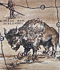 | Details | Holm, Bill | 1965 |
| Old West style pictorial map of the Permian Basin Texas New Mexico |
|
Holm, Bill |
|
| 1965 |
| LOC:89 |
| $350.00 | Holm--Bill | Old-West-style-pictorial-map-of-the-Permian-Basin-Texas-New-Mexico | Original Old-West-style pictorial map of the Permian Basin, Texas and New Mexico, created by Bill Holm and copyrighted circa 1965. This scarce pictorial map was compiled by the Permian Basin Chamber of Commerce Tourist Committee and published by Holm and West Texas Office Supply. The map retains the graphic and illustrative character typical of promotional region maps from the mid-20th century and was originally issued as part of an eight-panel folding brochure titled Ride the Permian Basin, The Official Guide to the History Lands of the Southwest. <br><br>
The map is centered on Odessa, Texas, and extends across the Permian Basin region of West Texas and southeastern New Mexico. It shows towns, roads, highways, and trails, along with pictorial figures and symbols representing Native Americans, buffalo, cowboys, and topographic features such as mesas and escarpments. A legend at right includes historic and overland routes such as the California Trail, overland stage paths, and the Comanche war trail. Named locations include Big Spring, Fort Lancaster, Midland, Fort Stockton, the McDonald Observatory, Guadalupe Peak, Carlsberg Caverns State Park, the Llano Estacado, and Castle Gap. <br><br>
This pictorial map is of interest to collectors of Western Americana, historical travel ephemera, and regional cultural cartography due to its representation of mid-20th century tourism promotion and its depiction of historic routes and landmarks in the Permian Basin. The original brochure format and illustrative style reflect local efforts to interpret and market the history and geography of the American Southwest during the 1960s. |
| 6613 | 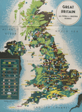 | Details | British Information Services | 1942 |
| Pictorial WWII era propaganda map Great Britain Natural and Industrial Resources |
|
British Information Services |
|
| 1942 |
| LOC:400 |
| $2,500.00 | British-Information-Services | Pictorial-WWII-era-propaganda-map-Great-Britain-Natural-and-Industrial-Resources | Large, lithographed poster-sized map: "Great Britain Her Natural & Industrial Resources" published circa 1942, during WWII, by British Information Services. On the verso a printed statement: "Printed in Great Britain." Scarce on the market and quite nicely executed.
<br><br>
At bottom right the attribution reads: "Distributed by British Information Services, an agency of the British Government, 30 Rockefeller Plaza, New York City." British Information Services was formed in 1941 as an office of the British Government with the goal to promote Britain's interests in the United States. Prior to December 1941 the United States had not formally entered into the war in Europe and this map poster was part of the propaganda Britain employed to sway U.S. opinion to its side. |
| 6609 | 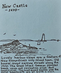 | Details | Nillson, Bob | 1974 |
| Map of East New Hampshire Seacoast with Pictorial Scenes of Activities |
|
Nillson, Bob |
|
| 1974 |
| LOC:62 |
| $375.00 | Nillson--Bob | Map-of-East-New-Hampshire-Seacoast-with-Pictorial-Scenes-of-Activities | Window on the Seacoast the Publick Occurrences Guide to Activities in the New Hampshire Seacoast.
An attractive sketched map of the New Hampshire Seacoast region surrounded by smaller sketches of local New Hampshire Seacoast attractions and activities. These include Prescott Park, New Castle, Fuller Gardens, Isle of Shoals, apple orchards, Kingston, Adams Point, UNH, and Route 125.
<br><br>
Copyrighted, conceived, and created by well-known New Hampshire artist, cartoonist, and teacher- Bob Nilson in 1974. Nilson is best known for his two-handed ambidextrous drawing method and, since the 1990's, for his caricature sketches of local Seacoast bands and performers. Here we have one of Nilson's earlier works, probably based on architectural and landscape sketches he submitted to the Portsmouth Herald for a section: Seacoast Sketchbook. (1)
<br><br>
(1) Online. Accessed 1/23. https://www.portsmouthnh.com/where-the-music-is-seacoast-music-scene-through-eyes-of-bob-nilson/ |
| 6598 | 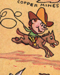 | Details | Dietemann, C.A. | 1934 |
| Scarce Pictorial Map Denver and Rio Grande Western Railroad |
|
Dietemann, C.A. |
|
| 1934 |
| LOC:400 |
| $250.00 | Dietemann--C-A- | Scarce-Pictorial-Map-Denver-and-Rio-Grande-Western-Railroad | C. A. Dietemann's scare pictorial map: Denver and Rio Grande Western (D&RGW) Railroad Scenic Line of the World spans four panels of a six-panel promotional brochure for the railroad featuring the Royal Gorge Route and the James Peak Route with the Moffat Tunnel, cutting through the Continental Divide. The map, dating from the mid 1930's features a wide expanse of the west including portions of New Mexico, Colorado, Utah and Arizona. From Salt Lake City to Denver, this fine map of routes for the Denver and Rio Grande Railroad entices the viewer to visit some of the West's greatest attractions including Mesa Verde National Park, Pikes Peak, Santa Fe, and Rocky Mountain National Park.
<br><br>
Dietemann's pictograms on this lithographed pictorial map feature numerous outdoor activities such as hiking, tennis, skiing, hunting, tobogganing, and fishing.
<br><br>
The D&RGW entered bankruptcy in 1935 and was not able to emerge from that status until 1947.
<br><br>
Only five holdings od Dietmann's pictorial map are found in WorldCat. No copies appear for sale on the market at this moment (01/23). |
| 6596 |  | Details | Brunswick Golden Isles Chamber of Commerce | 1963 |
| Treasure Map Brunswick and Golden Isles Georgia |
|
Brunswick Golden Isles Chamber of Commerce |
|
| 1963 |
| LOC:89 |
| $120.00 | Brunswick-Golden-Isles-Chamber-of-Commerce | Treasure-Map-Brunswick-and-Golden-Isles-Georgia | Ye Olde Treasure Map Brunswick and the Golden Isles of Georgia is a fact-filled pirate-themed pictorial map of Brunswick and the Golden Isles of Georgia. Includes Jekyll Island, Saint Simons Island, and Sea Island. At right, an inset large-scale context map of the United States East Coast.
<br><br>
Blackbeard says hoist your wallet and heave your doubloons on this one before she sails away. Arrgh! |
| 6579 | 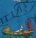 | Details | Deering, Roger L. | 1941 |
| Unrecorded pictorial map Portland Maine by Maine artist Roger Deering |
|
Deering, Roger L. |
|
| 1941 |
| LOC:3 |
| $575.00 | Deering--Roger-L- | Unrecorded-pictorial-map-Portland-Maine-by-Maine-artist-Roger-Deering | Unrecorded pictorial map of Portland, Maine copyrighted in 1941 by Maine artist Roger Deering.
<br><br>
Roger L. Deering (1904-1980) is best known for his paintings of Maine and is credited with creation of a series of small black and white prints for the Maine Bonding and Casualty Company of Portland, Maine.
<br><br>
Tri-fold brochure. Recto with text and black and white images explaining why the reader should "Make your headquarters in Portland". No reference found anywhere to "Playground Metropolis." |
| 6585 |  | Details | Mama Leone | 1960 |
| Large menu for Mama Leone's Restaurant in NYC |
|
Mama Leone |
|
| 1960 |
| LOC:57 |
| $225.00 | Mama-Leone | Large-menu-for-Mama-Leone-s-Restaurant-in-NYC | Large original menu from Mama Leone's restaurant in New York City circa 1960. Colorful pictorial map of Italy at center at center divided into administrative regions with each region promoting one or more of Mama Leone's wine offerings, for example Frecciarossa, Brachetto, Lambrusco, or Verdiccio or another of the available wines. Mama Leone's restaurant closed in 1994.
<br><br>
Inset photo of Mama Leone at top right. |
| 6589 | 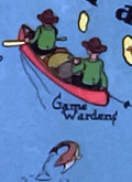 | Details | W. A. Fisher Company | 1936 |
| Pictorial map of Kabetogama Lake Minnesota |
|
W. A. Fisher Company |
|
| 1936 |
| LOC:59 |
| $325.00 | W--A--Fisher-Company | Pictorial-map-of-Kabetogama-Lake-Minnesota | Scarce original pictorial map of Kabetogama Lake, Minnesota. Kabetogama means "rough waters" in Chippewa. Created by Frank M. Antoncich. Published by the W. A. Fisher Company, Virginia, Minnesota. Date of 1936 from the example in the Rumsey Collection. Price when issued was 25 cents.
<br><br>
Along with and cute cartographs including bears and Native Americans the map is filled with useful navigational information and historical facts. Portages, trails and roads are laid out. Many canoes.
<br><br>
Notes and observations about the area include:<br>
<div class="indenttextblocksingle">
<ul style="list-style-type: circle;"></li>
<li>an "Indian Village",</li>
<li>"Funeral Island Burial Ground"</li>
<li>the "Yates Resort",</li>
<li>"Mrs. McCaw- first white woman and homestead here",</li>
<li>"Good duck hunting", and</li>
<li>"Impassable in low water".</li>
</ul>
</div> |
| 6584 | 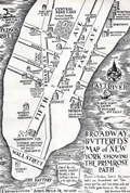 | Details | Held, John Jr. | 1931 |
| Pictorial Map of Lower Manhattan or Broadway Butterfly's Map |
|
Held, John Jr. |
|
| 1931 |
| LOC:89 |
| $200.00 | Held--John-Jr- | Pictorial-Map-of-Lower-Manhattan-or-Broadway-Butterfly-s-Map | John Held, Jr., (1889-1958) was a cartoonist, illustrator, printmaker and author. Held's cartoons satirized and epitomized the United States' “Jazz Age” of the 1920s. Here, Held's cartoon for "Broadway Butterflys" satirizes the fast life of the New York elite with its focus on Wall Street, Broadway, Fifth Avenue, and Park Avenue. Shows the Jefferson Market Night Court, now the Jefferson Market Branch of the New York Public Library and the morgue, "end of the Primrose Path." Presumably Held included the image to illustrate his story, “Broadway Butterfly,” in Held's second published collection of short stories, Dog Tales (1930).
<br><br>
Verso with an engraving by Held: "When the Theatre was Fraught with Romance."
<br><br>
Held was apparently a VERY popular cartoonist before the Depression. According to New York's Center Gallery: <div class="indenttextblocksingle">"He lived in the era of cartoonists as national heroes. In 1927, Vanity Fair named Held to its “Hall of Fame” alongside international luminaries of the decade. The Hearst newspapers paid him $250,000 a year (nearly $4,000,000 today, adjusted for inflation) for his cartoon strip, Oh! Margy, and his drawings sold for up to $5,000 each, roughly the price of a house." (1)
</div><br>
(1) Online. Retrieved December, 2022. https://www.centergallerynyc.org/exhibitions/johnheldjr |
| 6580 | 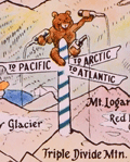 | Details | Scheuerle, Joseph G. | 1925 |
| Pictorial Map of Glacier National Park |
|
Scheuerle, Joseph G. |
|
| 1925 |
| LOC:68 |
| $675.00 | Scheuerle--Joseph-G- | Pictorial-Map-of-Glacier-National-Park | Striking pictorial map of Glacier National Park from 1925 by Joseph G. Scheuerle (1873-1948). Published by the Great Northern Railway. This pictorial map documents Blackfoot Glacier, Harrison Glacier, Pumpelly Glacier, Sperry Glacier, Red Eagle Glacier, Carter Glacier, Dixon Glacier, Sexton Glacier Grinnell Glacier, Ahern Glacier, and Iceberg Lake (1).
<br><br>
Glacier National Park in 1925 was a popular destination for tourists who were seeking adventure, breathtaking scenery, and a chance to experience the great outdoors- hiking, by pack train, or by car. The Going-to-the-Sun Road was completed in 1932, but construction began in 1919. In 1925, visitors could drive part of the road, which offered stunning views of the park's glaciers, mountains, and valleys.
<br><br>
The Many Glacier Hotel was completed in 1915, but it underwent extensive renovations in the early 1920s. By 1925 the hotel had been transformed into a luxurious mountain retreat with modern amenities such as electricity, running water, and telephones.
<br><br>
Around 1873 Joe Scheuerle, moved to Ohio, where he eventually studied at the Cincinnati Art Academy. Best known for his portraits of Native Americans, beginning in 1909, Scheuerle made many visits to Indian reservations in Montana and across the West. He produced "more than 200 exceptional portraits of native American's" (2). One need only look at the title cartouche to understand that Scheurle's portraits greatly influenced this map.
<br><br> |
| 6581 | 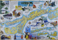 | Details | Mickey, William | 2000 |
| Pictorial map of Marathon and the middle Florida Keys 1st |
|
Mickey, William |
|
| 2000 |
| LOC:130 |
| $250.00 | Mickey--William | Pictorial-map-of-Marathon-and-the-middle-Florida-Keys-1st | Beautifully illustrated and scarce first edition pictorial folding map of the middle Florida Keys including Marathon Key circa 2000. First edition published by William Mickey Art and Design. Map is annotated with names of local businesses.
<br></br>
This original pictorial Map and Guide of Marathon and the Middle Keys is a richly detailed illustrated map of the Florida Keys, centered on Marathon and extending east and west across the Middle Keys. Designed as both a street and harbor guide and a visual souvenir, it presents canals, marinas, bridges, neighborhoods, and waterways alongside bold hand drawn artwork. The combination of practical cartography and colorful illustration makes this map immediately appealing to collectors of Florida Keys maps, Marathon memorabilia, nautical charts, and vintage Florida travel ephemera.<br><br>
The map also serves as an illustrated historical overview of Marathon and its development. Text panels and imagery reference the Calusa Indians, Bahamian fishermen, the arrival of the Overseas Railroad, and the role of Henry Flagler in shaping the Keys as a connected island chain. Historic portraits, early transportation scenes, and descriptive notes provide context for how Marathon evolved from a railroad outpost into one of the largest and most important communities in the Middle Keys. Insets clarify the geography of the islands and emphasize the narrow, linear nature of settlement along the Overseas Highway.<br><br>
Marine life and coastal culture are central to the design, with prominent illustrations of sailfish, marlin, dolphin, reef fish, seabirds, coral, and fishing scenes framing the map. Harbors, channels, beaches, parks, and attractions are clearly labeled, reinforcing the area’s long association with boating, sport fishing, and tourism. |
| 6567 | 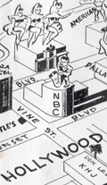 | Details | Anonymous | 1949 |
| Castles Inc. map of Hollywood and Los Angeles |
|
Anonymous |
|
| 1949 |
| LOC:3 |
| $750.00 | Anonymous | Castles-Inc--map-of-Hollywood-and-Los-Angeles | Clean, single-sided pictorial advertising map of Hollywood and the surrounding area circa 1948 published by Castle's Camera Store, 1529 Vine Street, Hollywood 28, California. Scarce. Price when issued 5 cents.
<br></br>
Castle's Camera Store operated from a small storefront across from the streamline-moderne style NBC Radio City office and studios at the corner of Sunset and Vine streets. <br></br>
<div>
<img src="/ZoomifyImages/SC_6567/Castles Camera Shop.jpg" alt="Castle's Camera Store Hollywood Storefront" width="300" align="left" style="margin: 0px 20px"/>
Karl Breneman was brother to radio personality Tom Breneman who operated Tom Breneman's restaurant from a location at 1525 North Vine Street, a few doors from brother Karl's Castle's Camera Shop.
<br></br>
Key landmarks on the map include:
<div class="indenttextblocksingle">
<ul style="list-style-type: circle;">
<li>Don Lee Mutual Broadcasting Studios (1313 North Vine Street opened August 1948)</li>
<li>Beverly Hills</li>
<li>Republic Studios</li>
<li>Grauman's Egyptian Theater</li>
<li>Hollywood Ball Park</li>
<li>a television studio</li>
<li>Earl Carrol's</li>
<li>Santa Monica, Ocean Park, and Venice piers</li>
<li>American Legion Stadium</li>
</ul>
</div> |
| 6564 | 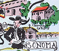 | Details | McCarty, Lea | 1955 |
| Scarce pictorial map of Sonoma County |
|
McCarty, Lea |
|
| 1955 |
| LOC:89 |
| $350.00 | McCarty--Lea | Scarce-pictorial-map-of-Sonoma-County | Fun, activity-oriented cartograph or pictorial map of Sonoma County, California by artist Lea McCarty. From a folding brochure "Fascinating Sonoma County in California's Redwood Empire Wonderland" issued in 1955 by the Sonoma County Board of Supervisors and Associated Chambers of Commerce of Sonoma Valley Inset context map withing a colorful compass rose shows Sonoma County in relationship to San Francisco and other nearby counties in California.
<br></br>
Coverage on this amusing map of Sonoma County includes portions of the surrounding counties: Napa County, Mendocino County and Marin County as well as numerous Sonoma County highlights to include:
<div class="indenttextblocksingle">
<ul style="list-style-type: circle;"></li>
<li>Bodega Bay</li>
<li>Bohemian Grove</li>
<li>Stewarts Point</li>
<li>Healdsburg</li>
<li>Digger Indian Reservation</li>
<li>Petrified Forest</li>
<li>Burbank Gardens, and</li>
<li>Petaluma</li>
</ul>
</div> |
| 6565 | 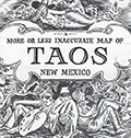 | Details | Lockwood, Ward | 1945 |
| Scarce pictorial map of Taos New Mexico by Ward Lockwood |
|
Lockwood, Ward |
|
| 1945 |
| LOC:89 |
| $325.00 | Lockwood--Ward | Scarce-pictorial-map-of-Taos-New-Mexico-by-Ward-Lockwood | Scarce mid-century pictorial map of Taos New Mexico by Ward Lockwood. This fine, humorous map of Taos comprises three panels in a folding brochure issued by the Taos Chamber of Commerce circa 1945.
<br></br>
<div class="indenttextblock">
<img src="/ZoomifyImages/SC_6565/SC_6565_Title.jpg" alt="Pictorial map of Taos New Mexico by Ward Lockwood, 1945" width="300" align="left" style="margin: 0px 20px">
</div>
<br></br>
Taos artist Ward Lockwood (1894-1963) attended the University of Kansas. Based in Taos (NM), Lockwood taught at the University of Texas (1938-49) and UC Berkeley (1949-61). |
| 6556 | 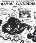 | Details | Anonymous | 1952 |
| Pictorial map New Orleans area near Bayou Gardens Lacombe Louisiana |
|
Anonymous |
|
| 1952 |
| LOC:3 |
| $150.00 | Anonymous | Pictorial-map-New-Orleans-area-near-Bayou-Gardens-Lacombe-Louisiana | Pictorial map (1952) of the New Orleans area to promote the Bayou Gardens attraction in Lacombe, Louisiana. The map spans the back two panels of a promotional brochure titled: "Bayou Gardens Lacombe, La. Beauty Spot of the Bayou Country."
<br><br>
Bayou Gardens was a 25-acre gardening attraction located north of New Orleans between Mandeville and Slidell. Bayou Gardens was founded in the late 1940's by convicted felon and former Louisiana Governor Richard W. Leche (1898-1965). In addition to a commercial nursery, swimming pool and a museum, according to the brochure "The Gardens contain one of the nation's outstanding Camelia collections, numbering hundreds of varieties."
<br><br>
Two-panel folding brochure with text on the recto. |
| 6551 | 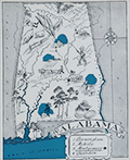 | Details | Johst, Paul Spener | 1931 |
| Johst pictorial maps of Alabama and Georgia |
|
Johst, Paul Spener |
|
| 1931 |
| LOC: |
| $135.00 | Johst--Paul-Spener | Johst-pictorial-maps-of-Alabama-and-Georgia | SOLD
<br><br>
Two pictorial maps of the states of Alabama and of Georgia in a pictorial cartoon-like style.
<br><br>
From "Picture Map Geography of the United States" by Vernon Quinn. With Picture Maps by Paul Spener Johst. Publisher: Frederick A. Stokes Company. New York. 1931. Some picture maps in the book contain depictions that today might be considered politically incorrect or even racist. |
| 6547 |  | Details | Gist, Gilman Jr. | 1943 |
| A Soldier's Guide to Palo Alto Pictorial WWII Era Map |
|
Gist, Gilman Jr. |
|
| 1943 |
| LOC:300 |
| $1,250.00 | Gist--Gilman-Jr- | A-Soldier-s-Guide-to-Palo-Alto-Pictorial-WWII-Era-Map | <br><br>
<div class="indenttextblocksingle">
"This cartoon guide makes it as easy as "Squads Right" to find that <b>place</b> you're looking for and right here within reach of all. If you want to splurge or just "gold-brick" away an evening this will show you just what you want and how to get there."
</div>
<br><br>
Rare pictorial map of Palo Alto, California by Gilman A. Gist Jr. (d. 1960) published in a 1943 issue of the Stanford Chaparral. The Stanford Chaparral or <i>Chappie</i> is a humor magazine published by students of Stanford University since 1899, the third oldest continually published humor magazine in the world.
<br><br>
Inset maps of Menlo Park, El Camino Real, and a stretch of Bayshore Highway. Includes light-hearted images of area restaurants, clubs, theaters and other businesses that a WWII G.I. might want to visit while on leave, as well as transportation. These fine establishments include:
<div class="indenttextblocksingle">
<ul style="list-style-type: circle;"></li>
<li>Bill and Walt Collins Club</li>
<li>Fat Boy Barbecue</li>
<li>O'Neil's Stanford Bowl</li>
<li>Dinah's Shack - real suthen chicken!</li>
<li>Varsity Theater</li>
<li>Stanford Theater</li>
<li>Clarence's Smoke Shop</li>
<li>Grab-a-bite</li>
</ul>
</div> |
| 6542 | 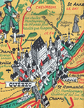 | Details | Turner, Stanley | 1948 |
| Pictorial map Saguenay region Quebec, Canada Stanley Turner 1948 |
|
Turner, Stanley |
|
| 1948 |
| LOC:300 |
| $400.00 | Turner--Stanley | Pictorial-map-Saguenay-region-Quebec--Canada-Stanley-Turner-1948 | Historical-pictorial map of the Saguenay region of Canada with Quebec by Stanley Turner, 1948. A tourist-oriented map published by Brading Brewery designed to encourage vacationers to visit the Saguenay area.
<br><br>
<div id="1" align="center">
<a title="TITLE HERE"></a>
<img id="1" src="/ZoomifyImages/SC_6542/SC_6542_detail.jpg" alt="Stanley Turner pictorial view of Quebec from Brading Brewery map 1948" width="340"/> <br><small>Stanley Turner pictorial view of Quebec.</small>
</div><br>
<div class="indenttextblocksingle">
"This map represents Bas-Saint-Laurent and Saguenay. A lot of information is offered on the map, such as main arteries, railroads, golf clubs, airports, crossings, battlefields, hydroelectric installations and hunting and fishing spots. Some historical information is also added such as dates of battles and discovery of territories. Drawings of inhabitants, animals or historical figures decorate the document."
</div><br>
Copyright 1948 Bradings Capital Brewery Ltd. Ottawa, Canada. French language.
<br><br>
[1] Online. https://archivesdemontreal.ica-atom.org/carte-de-vacances-brading-du-bas-st-laurent-et-de-la-region-de-saguenay-1949 |
| 6543 | 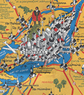 | Details | Turner, Stanley | 1948 |
| Pictorial map Laurentides region Montreal, Canada Stanley Turner 1948 |
|
Turner, Stanley |
|
| 1948 |
| LOC:300 |
| $500.00 | Turner--Stanley | Pictorial-map-Laurentides-region-Montreal--Canada-Stanley-Turner-1948 | Historical-pictorial map of the Laurentides region of Canada with Montreal by Stanley Francis Turner, 1948. A tourist-oriented map published by Brading Brewery designed to encourage vacationers to visit Montreal and the Laurentides region of Canada.
<br><br>
<div id="1" align="center">
<a title="Montreal, Canada"></a>
<img id="1" src="/ZoomifyImages/SC_6543/SC_6543_detail.jpg" alt="Stanley Turner pictorial view of Montreal, Canada from 1948 Brading Brewery map." width="340"/> <br><small>Stanley Turner pictorial view of Montreal, Canada.</small>
</div>
<br>
Copyright 1948 Bradings Capital Brewery Ltd. Ottawa, Canada. French language.
<br><br> |
| 6533 | 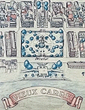 | Details | Fell, April P. | 1976 |
| Plan New Orleans Vieux Carre by April Fell |
|
Fell, April P. |
|
| 1976 |
| LOC:68 |
| $375.00 | Fell--April-P- | Plan-New-Orleans-Vieux-Carre-by-April-Fell | Scarce plan of the Vieux Carre or French Quarter in New Orleans, Louisiana by April P. Fell in 1976. Shows the buildings and street layout of the French Quarter as they existed in 1976. The limits of the Vieux Carre are the Mississippi River, Canal Street, Rampart Street, and Esplanade Avenue.
<br><br>
Todd and April Fell lived in New Orleans beginning in the 70s. They created a travel book called 'The Vignette' that was published until 1987.
<br><br>
Published by The Vignette 240 Rue Chartres. Copyright 1976. |
| 6526 | 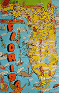 | Details | Skacel, Bill | 1946 |
| Pictorial Cartoon map of Florida Bill Skacel |
|
Skacel, Bill |
|
| 1946 |
| LOC:300 |
| $200.00 | Skacel--Bill | Pictorial-Cartoon-map-of-Florida-Bill-Skacel | Original, scarce pictorial map of the State of Florida by artist Bill Skacel ca. 1946. The humorous, historical cartoon map of Florida was produced ca. 1946 as a folded nine-panel tourist-oriented mailer with the verso containing space for an address as well as facts and photos of Florida
<br><br> |
| 6529 | 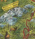 | Details | Green, Walter O. | 1951 |
| Western style pictorial map of the Colorado Rocky Mountains |
|
Green, Walter O. |
|
| 1951 |
| LOC: |
| $375.00 | Green--Walter-O- | Western-style-pictorial-map-of-the-Colorado-Rocky-Mountains | Interesting and scarce pictorial folding motor-tour map of a portion of Colorado near the Rocky Mountain National Park from 1951. Includes Boulder, Estes Park and much more in a western style complete with horse-riding cowboys, bucking broncos, and wizened prospectors. A serious map, not a hint of humor. Issued by the Rocky Mountain Motor Company, Denver, Colorado in 1951. Map by Walter O. Green.
<br><br>
Towns and cities on the map include:
<div class="indenttextblocksingle">
<ul style="list-style-type: circle;"></li>
<li>Denver</li>
<li>Evergreen</li>
<li>Golden</li>
<li>Boulder</li>
<li>Granby</li>
<li>Grand Lake</li>
<li>Estes Park</li>
<li>Fort Collins</li>
<li>Greely</li>
<li>Longmont</li>
<li>Lyons</li>
</ul>
</div>
Verso with color photographs, text, and motor tour schedules.
<br><br>
Green also identifies numerous geographical features
<div class="indenttextblocksingle">
<ul style="list-style-type: circle;"></li>
<li>Big Thompson Canyon</li>
<li>Iceberg Lake</li>
<li>Grand Lake</li>
<li>Arapaho Peak Elev. 13506 Ft.</li>
<li>Longs Peak Elev. 14255 Ft.</li>
<li>Red Rocks</li>
<li>Mount Evans Elev. 14360 Ft.</li>
<li>Berthoud Pass</li>
</ul>
</div> |
| 6516 |  | Details | Barnes, Myra Zimmerman | 1942 |
| Pictorial plan of New Orleans French Quarter of Vieux Carre |
|
Barnes, Myra Zimmerman |
|
| 1942 |
| LOC: |
| $375.00 | Barnes--Myra-Zimmerman | Pictorial-plan-of-New-Orleans-French-Quarter-of-Vieux-Carre | Very attractive lithographed pictorial map of the Vieux Carre (French Quarter) in New Orleans, Louisiana. Rolled with no folds. Barnes based the overall scope of her map and details on the walls surrounding the Vieux Carre on plans produced by surveyors Carlos Trudeau and Joseph Pilie from 1794 through 1808. Over this early framework Barnes has illustrated local architecture and history with elements of contemporary culture from the early 1940s .
<br><br>
The border is surrounded by vignettes of New Orleans and Louisiana history and culture as it existed in 1942 when Barnes created the map, as well as important key events such as two fires in 1788 and 1794 that destroyed many of the early wooden French structures in the city.
<div class="indenttextblocksingle">
<ul>
<li>The Southern Yacht Club</li>
<li>The Fairgrounds</li>
<li>The Bonnet Carre Spillway</li>
<li>Cutting sugar cane</li>
<li>Suicide Oak</li>
</ul>
</div> |
| 6506 | 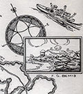 | Details | Dummer, H. Boylston | 1929 |
| Rare unrecorded pictorial historical map Boston South Shore |
|
Dummer, H. Boylston |
|
| 1929 |
| LOC: |
| $450.00 | Dummer--H--Boylston | Rare-unrecorded-pictorial-historical-map-Boston-South-Shore | Unrecorded and very scarce <strong>pictorial map of Boston's South Shore</strong> including the towns of Hingham and Cohasset. The map includes the locations of Bumkin Island, Weir River, World's End, Planters Hill, Sandy Beach, and Hominy Point. Inset illustrations of historical structures including the Garrison House, "Old Ship Church" and "The Old Ordinary" as well as named homes of local families including Ulman, Beal, Reilly, Donovan, Bolles, Foss and the entrance to the estate of Mrs. Thomas J. Plant and Mrs. E.R. Thayer's Weir River Farm.
<br><br>
No examples of the map in WorldCat, OWA, or AMPR. No other copies found online. An online search turned up another map by Dummer in a very similar style and format: "Points of Interest in Quaint Marblehead, published by the Marblehead Craft Shop.
<br></br>
Signed, and dated within to August 4, 1929, |
| 6507 | 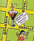 | Details | Skacel, Bill | 1946 |
| Pictorial Cartoon map of Vieux Carre New Orleans by Bill Skacel |
|
Skacel, Bill |
|
| 1946 |
| LOC:90 |
| $400.00 | Skacel--Bill | Pictorial-Cartoon-map-of-Vieux-Carre-New-Orleans-by-Bill-Skacel | Original, scarce pictorial map of the Vieux Carre or French Quarter in New Orleans, Louisiana by artist Bill Skacel ca. 1946. The humorous, historical "Cartoon Map of Vieux Carre in New Orleans" was produced ca. 1946 as a folded nine-panel tourist-oriented mailer with the verso containing space for an address as well as facts and photos of the New Orleans Vieux Carre.
<br><br>
Skacel takes a humorous angle at depicting Vieux Carre locations and culture in the post-WWII era. Two cartoon are puzzling- 1) four images of a young girl with pigtails wearing a sweatshirt bearing the letter "K" , that could possibly, represent a Catholic girl's school student or someone close to Skacel, and 2) at bottom right a matron crocheting a rug? with steel wire.
These cartoons include locations of:
<div class="indenttextblocksingle">
<ul style="list-style-type: circle;"></li>
<li>The Absinthe House, now the Old Absinthe House</li>
<li>Pirates Alley</li>
<li>Tabarry (Tabary) Theater</li>
<li>Napoleon House</li>
<li>A pelican</li>
<li>Blacksmith shop of Jean Lafitte</li>
<li>Cabildo prison</li>
</ul>
</div> |
| 6508 |  | Details | Moss, Ira | 1957 |
| Pictorial Sportsmen's Fishing Map United States and Neighboring Waters |
|
Moss, Ira |
|
| 1957 |
| LOC:141 |
| $275.00 | Moss--Ira | Pictorial-Sportsmen-s-Fishing-Map-United-States-and-Neighboring-Waters | Scarce original 1957 fisherman's map of the United States and Neighboring Waters designed by Ira Moss and produced by Barry, Moss, and Shore. Border is decorated with numerous images of fishing flies and saltwater fishing lures.
<br><br>
Saltwater fish, freshwater fish. Swordfish, bonefish, weakfish, flounder. Whitefish, bluefish, jewfish, croaker. No redfish but "channel bass" with a spot. Wahoo !
<br><br>
Includes small inset maps of the USA showing where a few specific species are most prevalent. Several inset tables: lists of saltwater fish, and freshwater fish; list of states and locations keyed to fish species,
<br><br>
Copyright 1957. Published by Shorewood Press, Fine Arts Publishers, New York. |
| 6513 | 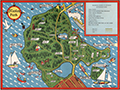 | Details | Page, Peter Hugh | 1940 |
| Fine second edition pictorial map of Stanley Park, Vancouver, British Columbia, Canada |
|
Page, Peter Hugh |
|
| 1940 |
| LOC:78 |
| $350.00 | Page--Peter-Hugh | Fine-second-edition-pictorial-map-of-Stanley-Park--Vancouver--British-Columbia--Canada | Beautiful lithographed pictorial map of Stanley Park, Vancouver, Canada by Peter Hugh Page, ca. 1940. Excellent condition. Second Edition. Shows Prospect Point, Brockton Point, Deadman's Island, Lost Lagoon, Second Beach, Beaver Lake and many other locations and attractions in Stanley Park.
<br><br>
<div align="center">
<a title="Stanley Park Cover"></a>
<img id="3" src="/ZoomifyImages/SC_6513/SC_6513_detail.jpg" alt="Cover from a brochure on Stanley Park, Vancouver, Canada by Peter Hugh Page in 1940." width="175"/> <br><small>Cover from Page's map of Stanley Park</small>
</div><br>
The second edition of Page's map of Stanley Park differs from the first edition in that it includes a depiction of the Lion's Gate Bridge (built 1939) and the label for Siwash Rock is removed. Verso with text about Stanley Park. |
| 6500 | 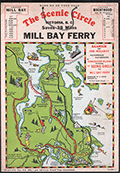 | Details | Page, Peter Hugh | 1936 |
| Rare pictorial map of Victoria, British Columbia with Ferry Routes |
|
Page, Peter Hugh |
|
| 1936 |
| LOC:78 |
| $350.00 | Page--Peter-Hugh | Rare-pictorial-map-of-Victoria--British-Columbia-with-Ferry-Routes | Rare pictorial auto map of Victoria, Vancouver Island, British Columbia, Canada featuring the Mill Bay Ferry route as an element of the Scenic Circle auto route. The map features numerous small cartoonish drawings of local activities including golfing, hunting, fishing, gardening, and horse racing. No holdings of this rare pictorial auto route map are found anywhere else online, nor any record of sales. Dated within to 1936.
<br><br>
Locations noted on the map include Telegraph Beach, Victoria Golf Club, James Island, Sidney, Sidney Island, Esquimalt Harbor, and Cordova Bay.
<br><br>
On card stock, this unusual piece of cartographic ephemera includes the original string hanger still attached through two punched holes.
<br><br>
Recto with departure times for the Mill Bay Ferry from both Malahat and from Brentwood. Verso with a photo of the ferry - M.S. Cascade, an inset smaller-scale sketch map of the Victoria surrounding area, a mileage table, and text on points of interest and suggestions for the Scenic Circle drive.
<div class="indenttextblocksingle">
"Ferry Trip across the placid waters of Saanich Arm, Sport Fishing preserve, where salmon up to 53-lbs. are taken and over fifty species of fish are found. From the Ferry can be seen Senanus Island, an ancient Indian burial ground, Bamberton Cement Works, Brentwood Cottage".
<br>and<br>
"A glance at the Map on the other side will convince you of the ease and simplicity of this Route. You can save MONEY, TIME and reduce your mileage from 83 to 45 by using this convenient connecting link [ferry] between Mr. BUTCHARTS GARNENS and the Famous MALAHAT DRIVE…"
</div> |
| 6499 |  | Details | Anonymous | 1939 |
| Fine colorful map of Bermuda ca. 1939. |
|
Anonymous |
|
| 1939 |
| LOC:90 |
| $125.00 | Anonymous | Fine-colorful-map-of-Bermuda-ca--1939- | An original and very attractive 7"x21" pictorial map of the Bermuda Islands on the recto of a folding promotional brochure for Bermuda in four panels. Numerous simple realistic sketches depict locations that include:
<div class="indenttextblocksingle">
<ul style="list-style-type: circle;">
<li>Ireland Island</li>
<li>Gibbs Hill Lighthouse</li>
<li>St. Paul's Church</li>
<li>Military Barrack Prospect</li>
<li>Harrington Sound</li>
<li>Tucker's Town</li>
<li>Shelly Bay Race Track</li>
<li>St. George</li>
<li>St. Catherines Point</li>
</ul>
</div>Inset street plans for St. George and for Hamilton. North oriented at upper right with a fine colorful compass rose. Text below the map includes latitude and longitude coordinates for Bermuda and a scale of miles.
<br><br>
The verso contains photos and text related to steamship service to Bermuda from several maritime firms including:
<ul style="list-style-type: circle;">
<div class="indenttextblocksingle">
<ul style="list-style-type: circle;"></li>
<li>The Furness Bermuda Line</li>
<li>The Pacific Steam Navigation Company</li>
<li>The Munson Steamship Lines</li>
<li>The Canadian National Steamships</li>
<li>Elders & Fyffes, Ltd.</li>
<li>New York Bermuda Lines</li>
</ul>
</div> |
| 6497 | 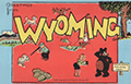 | Details | Skacel, Bill | 1946 |
| Pictorial Cartoon map of Wyoming |
|
Skacel, Bill |
|
| 1946 |
| LOC:90 |
| $250.00 | Skacel--Bill | Pictorial-Cartoon-map-of-Wyoming | Original, uncommon pictorial map of the State of Wyoming by artist Bill Skacel. The humorous, historical "Cartoon Map of Wyoming" was produced ca. 1946 as a folded nine-panel tourist-oriented mailer with the verso containing space for an address as well as facts and photos of the state of Wyoming.
<br><br>
Geographic coverage includes the towns of Jackson Hole, Cheyenne, Laramie, Kemmerer, Casper, and Cody as well as Yellowstone National Park.
<br><br>
Skacel's illustrations include moose, a horned dinosaur, Buffalo Bill, two devils, and a native-American maiden with teepee.
<br><br>
Copyright by E.C. Kropp Co. Milwaukee, Wis. C.M. 27. |
| 6493 |  | Details | Ohio Department of Highways | 1966 |
| Large pictorial map of the State of Ohio |
|
Ohio Department of Highways |
|
| 1966 |
| LOC:400 |
| $185.00 | Ohio-Department-of-Highways | Large-pictorial-map-of-the-State-of-Ohio | Large pictorial map of the State of Ohio. Copyrighted and published in 1966 by the Ohio Department of Highways.
<br><br>
<div id="3" align="center">
<a title="Detail from See the Wonderful World of Ohio map."></a>
<img id="3" src="/ZoomifyImages/SC_6493/SC_6493_Detail.jpg" alt="The Ohio River, 455 miles of water wonderland." width="360"/> <br><small>The Ohio River, 455 miles of water wonderland.</small>
</div><br>
Verso with additional road map, text, and photographs. |
| 6483 | 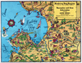 | Details | Sandefur, John Courtney | 1954 |
| Scarce pictorial cartograph or map Monterey Bay Hotel Jeffery |
|
Sandefur, John Courtney |
|
| 1954 |
| LOC:87 |
| $150.00 | Sandefur--John-Courtney | Scarce-pictorial-cartograph-or-map-Monterey-Bay-Hotel-Jeffery | Rare folding pictorial map of the Monterey Bay Region in California by John Courtney Sandefur. Sandefur's pictograms show the obvious influence of an earlier cartograph of the Monterey Region by Ruth Taylor White.
<br><br>
The map was published by Hotel Jeffery ca. early 1950s, then conducting business in Salinas, California for over 90 years. Colorful compass rose bearing a dog's image and the motto of the Hotel Jeffery- "Friendly."
<br><br>
Verso with text about the recreational activities and resources available in the Monterey Bay Area and the Salinas Valley including Pacific Grove, Carmel, Fort Ord, Santa Cruz, and Watsonville.
<br><br>
The Jeffery Hotel in Salinas, California was opened in 1888 at the corner of Alisal and Main Streets by William "Bill" Jeffery. In the 1970’s the original three-story Jeffery Hotel was demolished.<br><br>
<div id="0" align="center">
<a title="Hotel Jeffery, Salinas, California."></a>
<img id="3" src="/ZoomifyImages/SC_6483/SC_6483_HotelJeffery.jpg" alt="Photo of Hotel Jeffery, Salinas, California circa 1960" width="300"/> <br><small>Hotel Jeffery. <i>Courtesy U. California: https://calisphere.org/</i></small>
</div><br> |
| 6478 | 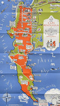 | Details | Boyle, Stuart | 1931 |
| Elegant lithographed pictorial map of the Cape Peninsula South Africa |
|
Boyle, Stuart |
|
| 1931 |
| LOC:14 |
| $550.00 | Boyle--Stuart | Elegant-lithographed-pictorial-map-of-the-Cape-Peninsula-South-Africa | Lovely, original pictorial map of the Cape Peninsula in South Africa by illustrator Stuart Boyle. Stuart Boyle illustrated several books including Evelyn Waugh’s The Loved One.
<br><br>
This fine map of the Cape Peninsula is characterized by elegant, colorful design and superb execution, with locations, notes, and literary quotes identified in scrollwork captions. These include:
<div class="indenttextblocksingle">
<ul style="list-style-type: circle;"></li>
<li>For the seas call and the stars call, and oh! the call of the sky- G. Gould.</li>
<li>White as sand of Muizenberg spun before the gale - Kipling.</li>
<li>Under hot Constantia broad the vineyards lie - Kipling</li>
<li>Good bathing to be had here.</li>
<li>Some say this drive in unequalled anywhere.</li>
<li>Fish simply ask to be caught here.</li>
<li>These are the twelve apostles</li>
</ul>
</div>
Only three holdings of this 1931 pictorial map are identified in WorldCat. No copies currently for sale were located.
<br><br>
Verso with text and numerous photogravure images of locations around the Cape Peninsula.
<br><br>
Issued by the Cape Peninsula Publicity Association and the South African Railways and Harbours Administration in 1931. Printed by the Cape Times. |
| 6472 | 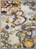 | Details | Shurtleff, Elizabeth | 1927 |
| Rare pictorial map of the Isle of Shoals |
|
Shurtleff, Elizabeth |
|
| 1927 |
| LOC:53 |
| $2,100.00 | Shurtleff--Elizabeth | Rare-pictorial-map-of-the-Isle-of-Shoals | Very rare original full-color lithographed pictorial map of the Isle of Shoals from 1927 designed and drawn by Elizabeth Shurtleff. Copyright by Jessie E. Donahue (1927). Beautiful, saturated colors. With verse by Celia Thaxter and Frederick T McGill.
<br><br>
Only two copies of Elizabeth Shurtleff's 1927 map of the Isle of Shoals were found in WorldCat. No record of a sale of the map was found online. A later much-revised edition of the Shurtleff's map was copyrighted and published in 1960 by Edward Rowe Snow.
<br><br>
Captain John Smith discovered the Isle of Shoals in 1664 lying about seven miles offshore on the border of what are today the states of New Hampshire and Maine. |
| 6464 |  | Details | Suyeoka, George | 1964 |
| VI-Daylin Natural History Map and National Heritage Map |
|
Suyeoka, George |
|
| 1964 |
| LOC:90 |
| $250.00 | Suyeoka--George | VI-Daylin-Natural-History-Map-and-National-Heritage-Map | Scarce pictorial map advertisement for Vi-daylin vitamins as a Natural History Map of the United States (recto). Verso with similar pictorial map but a National Heritage Map.
<br><br>
Not found online. Not in WorldCat.
<br><br>
Cartographs created by textbook illustrator, inventor, and commercial artist George Suyeoka (1926- 2015). Copyrighted and published in 1964 by Abbot Laboratories, North Chicago, Illinois. |
| 6465 |  | Details | Lindgren, Jolly | 1948 |
| Pictorial map of the Jackson Hole country and Grand Teton National Park |
|
Lindgren, Jolly |
|
| 1948 |
| LOC:90 |
| $600.00 | Lindgren--Jolly | Pictorial-map-of-the-Jackson-Hole-country-and-Grand-Teton-National-Park | "A hysterical map of the Jackson Hole country and Grand Teton National Park slightly cockeyed" a fine pictorial map of the area around Jackson Hole, Wyoming. "Made on purpose" by artist Jolly Lindgren, Spokane, Washington.
<br><br>
In addition to numerous mountains identified by name and height Lindgren's many features include Jackson Lake, Jenny Lake, Jackson Hamburgers, Resor Ranch, Church of the Transfiguration, the Federal Elk Refuge, and numerous dude ranches identified by large western-style hats. |
| 6466 |  | Details | Ambler, Edward Vassar | 1930 |
| Pictorial map of the Cape Ann Trail |
|
Ambler, Edward Vassar |
|
| 1930 |
| LOC:150 |
| $150.00 | Ambler--Edward-Vassar | Pictorial-map-of-the-Cape-Ann-Trail | Original 1930 pictorial map of the Cape Ann Trail, Massachusetts in a folding brochure (now flattened) published by the Gloucester, Massachusetts Chamber of Commerce. Attributed to Edward Vassar Ambler but the map is signed within the plate by "Mons". Copyright by Cottage Services, Inc. Text and cover on verso.
<br><br>
The map includes numerous pictograms highlighting key locations along the Cape Ann Trail. The border is filled with vignettes and text that provides detail about each feature. These features include:
<div class="indenttextblocksingle">
<ul style="list-style-type: circle;"></li>
<li>Norman's Woe</li>
<li>Five and Ten Pound Islands</li>
<li>Bass Rocks</li>
<li>Thatcher's Island</li>
<li>The Carillon Church</li>
<li>Ravenswood Park</li>
<li>Mother Ann</li>
<li>Rocky Neck</li>
</ul>
</div> |
| 6470 | 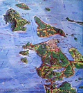 | Details | Pargeter, Richard Arnold | 1980 |
| Pictorial oblique topographic birds-eye view of the San Juan Islands |
|
Pargeter, Richard Arnold |
|
| 1980 |
| LOC:150 |
| $450.00 | Pargeter--Richard-Arnold | Pictorial-oblique-topographic-birds-eye-view-of-the-San-Juan-Islands | An original fine panoramic relief map of the San Juan Islands in Washington State on an oblique perspective. Copyright 1980 by Richard Pargeter. Printed by University Printing Company, Seattle. Pencil stock number in bottom right margin.
<br><br>
A self-taught cartographic illustrator, Pargeter's output includes similar panoramic relief maps of The Olympic Peaks, the Puget Sound Country, and Washington's Northwest Passages. In 1980, when this map was copyrighted, copies were available by mail-order from the Pargeter Company in Kent, Washington. Pargeter's maps were once available online but all available copies are reported as sold-out.
<br><br>
<div class="indenttextblocksingle">
"Tens of thousands of these maps have been sold over the years. All Pargeter's maps are true oblique projections. No planimetrics. All, but the pre-color-separated Olympic map have been full-color halftone shaded relief illustrations rendered in acrylics and a very fine brush, The renderings are based on U.S.G.S. topo quads with mountain "facial features" derived from aerial oblique angle photos taken by Pargeter". [1]
</div><br>
Source
<br><br>
[1] Online: Panorama maps. Pargeter. Online: http://www.panorama-map.com/pargeter/pargeter.html |
| 6525 |  | Details | Lindgren, Jolly | 1948 |
| Pictorial hysterical puzzle map of Utah and parks |
|
Lindgren, Jolly |
|
| 1948 |
| LOC:300 |
| $175.00 | Lindgren--Jolly | Pictorial-hysterical-puzzle-map-of-Utah-and-parks | Unused pictorial puzzle map of the State of Utah- "A hysterical map of Utah which includes Zion, Bryce Canyon, Cedar Breaks & Stinking Springs". "Made in broken English" by artist Jolly Lindgren, Spokane, Washington. Includes the original puzzle mailer with a transparent front. Lindgren-Turner Company.
<br><br>
A humorous tourist-oriented puzzle featuring the State of Utah and many of its numerous natural attractions including:
<div class="indenttextblocksingle">
<ul style="list-style-type: circle;"></li>
<li>Dinosaur National Monument</li>
<li>Zion National Park</li>
<li>Bryce Canyon</li>
<li>Escalante Desert</li>
<li>Natural Bridge</li>
<li>Arches National Monument</li>
<li>Skull Valley</li>
<li>Canyon de Chelly, Arizona</li>
</ul>
</div> |
| 6455 |  | Details | White, Ruth Taylor | 1929 |
| Six early pictorial airline route maps by Ruth Taylor White |
|
White, Ruth Taylor |
|
| 1929 |
| LOC:14 |
| $1,200.00 | White--Ruth-Taylor | Six-early-pictorial-airline-route-maps-by-Ruth-Taylor-White | Rare and fine eleven-page brochure for Western Air Express published in 1929, just three and one-half years after the airline was founded. Includes six pictorial airline route maps or cartographs by famed illustrator Ruth Taylor White. </b> Maps with inset half-tone images of aircraft and flight operations.
<br><br>
The Western Air Express Corporation, later Western Airlines, began its first passenger service in 1926 touting speed, comfort, and dependability. By 1928, employing Fokker Super Tri-motor passenger aircraft capable of transporting twelve passengers at a blistering 125 MPH, the airline "carried about eighteen percent of all inter-city passengers in the United States." In 1928 the company initiated a seaplane route from Catalina Island, California to Los Angeles, California. Maps include:
<div class="indenttextblocksingle">
<ul style="list-style-type: circle;"></li>
<li><b>San Francisco - Los Angeles.</b> 365 miles, 3 hours. "The Worlds Model Air Line." Two facing sheets, each 7.5" x 8"</li>
<li><b>Los Angeles - Kansas City.</b> 1,417 miles - 12 hours. First and fastest all Daylight Passenger Airway." Two facing sheets each 7.5" x 8".</li>
<li><b>Los Angeles to Catalina.</b> 45 miles - 30 minutes. "Over land and sea. The first air passenger service in the United States. Single center-fold sheet 15" x 8".<br>
<b> Los Angeles to Tia Juana or Agua Caliente".</b> 116 miles - 1 hour. With above. </li>
<li><b>Los Angeles - Salt Lake City.</b> 600 miles - 6 hours. "Over the Old Mormon Trail". Two facing sheets each 7.5" x 8".</li>
<li>Map of the USA showing expected travel-time zones, indicated by color legend. No title. One half sheet.</li>
<li>B&W inset map showing location of the Western Air Express Terminal south of San Gabriel. No title.</li>
<li>Cover 8" x 9" showing all included passenger routes for Western Air Express.</li>
</ul>
</div>
Publication date noted within as October, 1929. Folds down to 4" x 9". |
| 6540 |  | Details | White, Ruth Taylor | 1929 |
| Pictorial Western Air Express route map by Ruth Taylor White |
|
White, Ruth Taylor |
|
| 1929 |
| LOC:78 |
| $135.00 | White--Ruth-Taylor | Pictorial-Western-Air-Express-route-map-by-Ruth-Taylor-White | Pictorial airline route map or cartograph by famed illustrator Ruth Taylor White for Western Air Express published in 1929, just three and one-half years after the airline was founded. Inset half-tone images of an early seaplane and of Avalon Harbor on Catalina. <br><br>
<div id="1" align="center">
<a title="Western Air Express 1929 Seaplane"></a>
<img id="1" src="/ZoomifyImages/SC_6540/SC_6540_Seaplane.jpg" alt="Western Air Express 1929 Seaplane" width="300"/> <br><small>Western Air Express 1929 Seaplane, LA to Catalina</small>
</div><br>
This map include two routes flown from Los Angeles by Western Air Express:
<div class="indenttextblocksingle">
<ul style="list-style-type: circle;"></li>
<li><b>Los Angeles to Catalina.</b> 45 miles - 30 minutes. "Over land and sea. The first air passenger service in the United States.<br>
<b> Los Angeles to Tia Juana or Agua Caliente".</b> 116 miles - 1 hour.</li>
</div>
<div id="2" align="center">
<a title="Ruth Taylor White LA to Catalina route map details"></a>
<img id="2" src="/ZoomifyImages/SC_6540/SC_6540_Detail.jpg" alt="Ruth White map details" width="300"/> <br><small>Ruth Taylor White LA to Catalina route map detail</small>
</div><br>
The Western Air Express Corporation, later Western Airlines, began its first passenger service in 1926 touting speed, comfort, and dependability. By 1928, employing Fokker Super Tri-motor passenger aircraft capable of transporting twelve passengers at a blistering 125 MPH, the airline "carried about eighteen percent of all inter-city passengers in the United States." In 1928 the company initiated a seaplane route from Catalina Island, California to Los Angeles, California. Publication date: October, 1929. |
| 6452 |  | Details | Utz, Thornton | 1965 |
| 60s Pictorial map of Sarasota Florida |
|
Utz, Thornton |
|
| 1965 |
| LOC:87 |
| $300.00 | Utz--Thornton | 60s-Pictorial-map-of-Sarasota-Florida | Pictorial map of Sarasota, Florida and surrounding areas ca. 1965. Designated the Official Chamber of Commerce map, it shows a single span of the old Sunshine Skyway bridge. Copyrighted and published by Thornton Utz as the Limited Gift Edition, this printing of Utz's Map of Sarasota was presented as a service by the Sarasota bank and Trust Company.
<br><br>
<div id="1" align="center">
<a title="Sarasota Florida Pictorial Map"></a>
<img id="3" src="/ZoomifyImages/SC_6452/SC_6452_Detail.jpg" alt="1960s Pictorial Map of Sarasota, Florida by Utz" width="340"/> <br><small>Detail from Utz's Map of Sarasota, Florida</small>
</div><br>
Utz included sketches of numerous commercial and recreational activities in his map including:
<div class="indenttextblocksingle">
<ul style="list-style-type: circle;"></li>
<li>Siesta Key and Longboat Key</li>
<li>Sarasota Jungle Gardens</li>
<li>Chicago White Sox training camp</li>
<li>Bradenton Art Center</li>
<li>Camp Flying Eagle Boy Scout camp</li>
<li>Crescent Beach and Lido Beach</li>
<li>Forest Lakes County Club</li>
<li>Ringling Museum</li>
</ul>
</div>
Based on the $3.00 price stated for an mail-order autographed copy of the map, it appears to predate the version of the map held at the Touchton Map Library which carries a $5.00 price and lacks the reference in the title cartouche to Sarasota Bank and Trust. |
| 6697 |  | Details | Lepper, Ruth Rhoads | 1977 |
| Pictorial Map Maine Coast Between Casco Bay Penobscot Bay Lepper |
|
Lepper, Ruth Rhoads |
|
| 1977 |
| LOC:87 |
| $450.00 | Lepper--Ruth-Rhoads | Pictorial-Map-Maine-Coast-Between-Casco-Bay-Penobscot-Bay-Lepper | A Map of the Maine Coast Between Casco and Penobscot Bays made and published circa 1977 by Ruth Rhoads Lepper, West Southport, Maine. The prominent compass rose topped by a fleur-de-lis is a signature feature of Ruth Lepper pictorial maps and in this case is uncolored. Geographic coverage includes only those areas of the Maine Coast between Casco Bay and Penobscot Bay.
<br><br>
Map is dated with reference to a very similar larger-scale map held at the Osher Library: The Maine Coast from Kittery to Cape Elizabeth."
<br><br>
Lepper included brief facts on her coastal maps related to local maritime history:
<div class="indenttextblocksingle">
<ul style="list-style-type: circle;">
<li>On September 5, 1813, the U.S. brig. 'ENTERPRISE' captured the British brig. 'BOXER' The battle was fought in these waters. Both captains were killed.</li>
<li>Dixie Bull, the pirate. sailed into Pemaquid- In 1632. He sacked the trading post & dwellings, carrying away booty amounting to 2500.</li>
<li>The Virginia, first ship built by Englishmen on this Continent, was launched at Popham in 1608.</li>
<li>Allen's Island - Aug. 9,1607 Colonists from "Gift of God" & "Mary & John" listen to a sermon of Thanksgiving -the first English service on New England soil.</li>
</ul>
</div> |
| 6437 |  | Details | Flachmann, Chuck | 1950 |
| Pictorial or cartoon map of St. Louis Missouri |
|
Flachmann, Chuck |
|
| 1950 |
| LOC:90 |
| $350.00 | Flachmann--Chuck | Pictorial-or-cartoon-map-of-St--Louis-Missouri | Pictorial map of St. Louis, Missouri. Specifically, the Anheuser-Busch variant edition of Chuck Flachman's Cartoon Map of St. Louis, 1950. Two prominent identifying features distinguish the Anheuser-Busch variant edition from Flachman's pictorial "Mound City Pride of the Mississippi Valley" edition: 1) The Busch Budweiser logo appears at bottom left rather than the compass rose and 2) the lettering surrounding the map reflects its Mound City moniker. Additionally, the Busch brewery and Clydesdale horses are featured on the map in the Busch edition. Both editions are dated 1950.
<br><br>
Scarce, the Busch-Budweiser variant is much less common on the market in our experience. |
| 6385 | 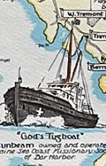 | Details | Lepper, Ruth Rhoads | 1965 |
| Pictorial Map of the Maine Coast from Rockland Schoodic Corea |
|
Lepper, Ruth Rhoads |
|
| 1965 |
| LOC:87 |
| $600.00 | Lepper--Ruth-Rhoads | Pictorial-Map-of-the-Maine-Coast-from-Rockland-Schoodic-Corea | Fine, bright, pictorial map of the Maine Coast from Rockland, through Schoodic to Corea by Ruth Rhoads Lepper, West Southport, Maine. Second Edition ca. 1965. Printed by the Spaulding-Moss Company, Boston, Massachusetts. Inset map of the Schoodic Peninsula. Filled with numerous historical facts and notes.
<br><br>
David Rumsey estimates the date of a later, third edition at 1970.
<br><br> |
| 6403 | 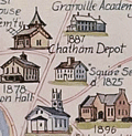 | Details | Rich, Howard L. | 1979 |
| Pictorial Historical Map of Chatham Massachusetts |
|
Rich, Howard L. |
|
| 1979 |
| LOC:87 |
| $225.00 | Rich--Howard-L- | Pictorial-Historical-Map-of-Chatham-Massachusetts | A fine original, first edition, pictorial historical map of Chatham, Massachusetts. Why buy a cheap copy when you can have the original version for a few dollars more?
<br></br>
The map shows numerous historical points of interest, those features no longer existing are shown in green font color. Includes an inset map of Monomoy Island and a smaller inset graphic representing the attack on Fort Fortune during October, 1606. Verso is blank.
<br></br>
Key geographical features on this historical map include Lookout Hill, Stage Harbor, Old Harbor, Great Beach, Strong Island, Great Hill, Morris Island, and Hardings Beach. Among the many historical events and locations that Rich chose to represent are the Mass. Humane Society hut for shipwrecked sailors, Old Harbor Life Saving Station, a ship's block factory, an Indian meeting house and burial ground, and the numerous salt works near Ryder's Cove.
<br></br>
Drawn by Howard L. Rich in 1979. Published by the Chatham Historical Society. |
| 6404 | 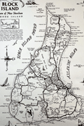 | Details | Overly, Charles H. | 1973 |
| Block Island Town of New Shoreham Rhode Island |
|
Overly, Charles H. |
|
| 1973 |
| LOC:87 |
| $185.00 | Overly--Charles-H- | Block-Island-Town-of-New-Shoreham-Rhode-Island | Very nice pictorial map of Block Island, Rhode Island lying in Block Island Sound. A better quality edition after Charles H. Overly's original map first printed in 1957. The map is printed on laid paper with a light brown tint throughout to simulate age. Scarce.
<br><br>
Esta Gray operated a gift shop in Old Harbor, Block Island- Esta's Gifts of Distinction. In 1957 Esta commissioned Charles H. Overly draw the map of Block Island to sell to tourists visiting her shop. This edition of the map is estimated circa 1973 after Charles Overly's map which contained a double decorative border and a 1957 copyright notice among other differences.
<br><br>
Charles H. Overly (1908-1970) was a University of Vermont graduate and artist. Returning home after a long tour of Europe, Overly began the Charles H. Overly Studio in 1938. He is best known for sketches and paintings of New England historical landmarks. |
| 6405 | 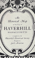 | Details | Atherton, Jack Bonney | 1940 |
| Rare Original Historical Map of Haverhill Massachusetts LeBaron-Bonney |
|
Atherton, Jack Bonney |
|
| 1940 |
| LOC:77 |
| $750.00 | Atherton--Jack-Bonney | Rare-Original-Historical-Map-of-Haverhill-Massachusetts-LeBaron-Bonney | Fine original antique pictorial map of Haverhill, Massachusetts dated within to 1940. Map was compiled by the Haverhill Historical Society, copyrighted and published by the LeBaron-Bonney Company of Bradford, Mass.
<br><br>
Apparently quite scarce. WorldCat shows only one institutional holding, at the Peabody Essex Museum.
<br><br>
Inset key to 38 historical locations identified numerically on the map. Some of those 39 locations with historical significance are depicted in inset graphic sketches including Buttonwoods, the old covered bridge, Kimball Tavern, the old Haverhill Academy, John Ward house, and the first post office.
<br><br>
This pictorial or picture map of Haverhill was designed by Jack Atherton and printed on paper with a light brown tint. Lee (LeBaron) Atherton and Jack (Bonney) Atherton opened the LeBaron-Bonney Co. as a bicycle rental business on Cape Cod in 1938, and expanded into a direct mail business offering pictorial and historic maps. |
| 6410 | 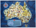 | Details | Santos, George | 1959 |
| Rare pictorial map of Australia with local fauna produced for Shell Oil Company |
|
Santos, George |
|
| 1959 |
| LOC:89 |
| $1,200.00 | Santos--George | Rare-pictorial-map-of-Australia-with-local-fauna-produced-for-Shell-Oil-Company | A very beautiful original 1959 lithographed pictorial map of Australia decorated profusely with drawings of Australian animals. Guaranteed original. Scarce on today's market.
<br><br>
Artwork by George Santos for the Shell Oil Company of Australia. Shell Oil Company logo at upper left.
<br><br>
Overall dimensions: 17.5 in. x 22.25 or 45 cm. x 57 cm.
<br><br>
Legend contains an inset key map and a list that denotes the names of the animals related numerically to positions on the key map.
<br><br>
Very rare. Only two institutional holdings are cataloged in WorldCat, both within Australia. |
| 6411 |  | Details | Overly, Charles H. | 1957 |
| 1st ed. Block Island Town of New Shoreham Rhode Island |
|
Overly, Charles H. |
|
| 1957 |
| LOC:89 |
| $450.00 | Overly--Charles-H- | 1st-ed--Block-Island-Town-of-New-Shoreham-Rhode-Island | Very nice original pictorial map of Block Island, Rhode Island lying in Block Island Sound by Charles H. Overly. First edition map printed in 1957. The map is printed on laid paper with a light brown tint throughout to simulate age.
<br><br>
Esta Gray operated a gift shop in Old Harbor, Block Island- Esta's Gifts of Distinction. In 1957 Esta commissioned Charles H. Overly to draw the map of Block Island to sell to tourists visiting her shop. This edition contains Esta' Grays 1957 copyright notice and a double decorative rope-work border.
<br><br>
Charles H. Overly (1908-1970) was a University of Vermont graduate and artist. Returning home after a long tour of Europe, Overly began the Charles H. Overly Studio in 1938. He is best known for sketches and paintings of New England historical landmarks. |
| 6391 |  | Details | Varvatis Brothers | 1962 |
| Very scarce pictorial map of Greece |
|
Varvatis Brothers |
|
| 1962 |
| LOC:150 |
| $500.00 | Varvatis-Brothers | Very-scarce-pictorial-map-of-Greece | Pictorial map of Greece. Scarce.
<br></br>
Produced by Hellenic Pictorial Cartography of Varvatis Brothers established 1930 Patent 10221 Copyright Varvatis Brothers.
<br></br>
Only one copy found in WorldCat, at BnF. |
| 6387 | 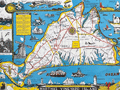 | Details | Parker, Larry | 1955 |
| Pictorial Map of Martha's Vineyard Island, Massachusetts |
|
Parker, Larry |
|
| 1955 |
| LOC:87 |
| $750.00 | Parker--Larry | Pictorial-Map-of-Martha-s-Vineyard-Island--Massachusetts | Original, scarce, 1950's Martha's Vineyard Island, Massachusetts pictorial map by Larry Parker. This lithographed tourist map features bright, bold colors, inset pictorial images of island life, and text blocks of historical facts, all hallmarks of a tourist souvenir map. Slight gloss to the paper finish as typical.
<br></br>
Remarkable condition.
<br></br>
This 1950's era edition is based on Parker's earlier 1935 black and white map of Martha's Vineyard Island. Not only does the new edition feature vivid lithographed color, several changes were made to the content including below the rope-wrapped bollard where the text "Edgartown Harbor" does not appear directly below the bollard. On this colored edition of Parker's map the area is blank. |
| 6388 |  | Details | Phillips, Luther Savage | 1963 |
| Pictorial Map of Penobscot Bay Rare 2nd Edition |
|
Phillips, Luther Savage |
|
| 1963 |
| LOC:87 |
| $550.00 | Phillips--Luther-Savage | Pictorial-Map-of-Penobscot-Bay-Rare-2nd-Edition | Rare second edition of L. S. Phillips's (Luther Savage Phillips) 1940 first edition pictorial map of Penobscot Bay: "A Decorative Map of Penobscot Bay Region Showing the tidal coast of Maine from Camden to Blue Hill and Islesboro to Bangor."
<br><br>
This fine map is credited to Augustus D. Phillips, Luther's son, in 1963. Author attribution and dates are within, below left of the compass rose. Printed on quality laid paper.
<br><br>
No copies of A.D. Phillip's second edition are found online including WorldCat and AMPR. |
| 6367 |  | Details | Leisen, Theodore | 1949 |
| Theodore Leisen Pictorial Map of Key West Florida |
|
Leisen, Theodore |
|
| 1949 |
| LOC: |
| $225.00 | Leisen--Theodore | Theodore-Leisen-Pictorial-Map-of-Key-West-Florida | Scarce medium-format pictorial map of Key West, Florida by Theodore Leisen Jr. The map of Key West map is undated but ca. 1949 based on Leisen's population estimate of 20,000 at publication. The population of Key West in 1950 is recorded as 21,792 persons excluding military personnel [1].
<br></br>
The map / brochure published by the Key West Chamber of Commerce contains a legend with numerous points of interest in Key West. Recto with map of the "World Famous Overseas Highway" from Key Largo to Key West. Key West translates to Cayo Hueso in Spanish.
<br></br>
[1] Wilkinson, Jerry. History of Key West. Online: http://www.keyshistory.org/keywest.html |
| 6428 |  | Details | Anonymous | 1949 |
| Cartoon map of UC Berkeley engineering underground radiation nuclear laboratory |
|
Anonymous |
|
| 1949 |
| LOC:300 |
| $850.00 | Anonymous | Cartoon-map-of-UC-Berkeley-engineering-underground-radiation-nuclear-laboratory | Original centerspread 1949 cartoon pictorial map, "Underground Campus", the campus of the University of California Berkeley, specifically the engineering underground tunnels and facilities including the Radiation Lab. Scientists at the UC Radiation Laboratory, now the Lawrence Berkeley National Laboratory, discovered berkelium (atomic number 97) in 1949 using a 60-inch cyclotron.
<br></br>
<div id="3" align="center">
<a title="California Engineer smoking weed?"></a>
<img id="3" src="/ZoomifyImages/SC_6428/SC_6428_SmokingWhat.jpg" alt="Early depiction of a Berkeley Engineer with roach clip." width="240"/>
</div><br>
The California Engineer began in 1903 as the California Journal of Technology. It was the first college magazine in the west to specialize in the area of science and technology. In January, 1923, after a hiatus of ten years, the magazine was revived and renamed "California Engineer" by the Student Engineers Council (1).
<br></br>
The comical map is centered around Sather Tower with a cutaway view of the subterranean network below the halls at the University of California at Berkeley. Includes Sather tunnel, Leconte Hall, Gilman Hall, Wheeler Auditorium, The Radiation Laboratory housed the research at UC Berkeley during WWII under the Manhattan Project. Note the IBM punch card machine gag at bottom left.
<br></br>
The comical map is from the January 1949 issue of <b>California Engineer</b>, the annual "Mad Issue". 36 pages. Price when issued 25 cents. Published at the University of California, Berkeley, California by the Associated Students of the University of California. |
| 6345 |  | Details | Roberts, Mike | 1966 |
| South Vietnam pictorial map mid-war era |
|
Roberts, Mike |
|
| 1966 |
| LOC:300 |
| $300.00 | Roberts--Mike | South-Vietnam-pictorial-map-mid-war-era | Fine pictorial poster-size map of South Vietnam. Created and published during the middle of the Vietnam War (1966) by Mike Roberts Color Productions. Map contains pictorial scenes of everyday life and of Vietnam War era aircraft and ships. Numerous inset photographs with scenes from simple Vietnamese everyday life, all in a format that suggests probable prior use as tourist-oriented postcards. (1)
<br></br>
Mike Roberts (1905-1989) was known as America's Postcard King. Roberts had a long career in color photography and printing that spanned more than 50 years. He became an important pioneer of Kodachrome postcards in the United States. (2)
<br></br>
Sources:<br />
(1) http://archiveswest.orbiscascade.org/ark:/80444/xv643950<br />
(2) https://www.huffpost.com/entry/wish-you-were-heremike-ro_b_7875752
<br></br>
[Fine pictorial map of Vietnam.] |
| 5493 |  | Details | Dornbush, Adrian | 1935 |
| Public Works of Art Project brochure variant 2nd Edition map Coral Isle of Key West |
|
Dornbush, Adrian |
|
| 1935 |
| LOC:500 |
| $285.00 | Dornbush--Adrian | Public-Works-of-Art-Project-brochure-variant-2nd-Edition-map-Coral-Isle-of-Key-West | Two scarce maps including a rare presumed 2nd. "The Coral Isle of Key West" Florida in a visitor's guide booklet simply titled "Key West" published by the Key West Administration after 1935. The booklet is a product of the Public Works of Art Project (PWAP) during the New Deal that was succeeded by the Federal Art Project of the Works Progress Administration (WPA).
<div class="indenttextblocksingle">
"Public Works of Art Project artists from other parts of the country were brought in and put to work creating paintings, murals or public places, and other projects, such as tourist brochures and postcards." [1]
</div><br>
<div id="3" align="center">
<a title="Key West Booklet"></a>
<img id="3" src="/ZoomifyImages/SC_5493/SC_5493_Cover_400x300.jpg" alt="Dornbush pictorial map The Coral Isle of Key West." width="240"/>
</div>
<br />
Other FERA artists who contributed works to the brochure include Edward Bruce, Richard Sargeant, Avery Johnson, Klir Beck, and Richard Jansen.<br>
</br>
The brochure includes a fine 9" x 6" pictorial map of Key West, Florida: "The Coral Isle of Key West" by artist Adrian Dornbush, 1935. Second edition. This map is most interesting in that it is an <b>unrecorded substantial revision of Dornbush's original map of Key West.</b> This edition contains numerous changes from the first edition including:
<div class="indenttextblocksingle">
<ul>
<li>For the first time, an airport is noted in the location of Meacham Field, now Key West International Airport (EYW)</li>
<li>Seaplane ramps at Trumbull Point (labeled "Key West Airways") are replaced with ship docks. </li>
<li>Radio towers are now shown located at the island's west side near Duval Street.</li>
</ul>
</div>
The map was engraved on a "miraculous" scale and shows key landmarks such as Duval Street, the lighthouse, the Martello Towers, and the yacht basin.
<br></br> |
| 5472 |  | Details | High Times | 1985 |
| Late 20th C map of International Drug Production |
|
High Times |
|
| 1985 |
| LOC:87 |
| $225.00 | High-Times | Late-20th-C-map-of-International-Drug-Production | Thematic, pictorial, world map focused on the agricultural and manufacturing/refining sites that produced illegal drugs in the mid 1980's. A two-page "Bonus Centerfold" to a 1985 issue of <i>High Times</i> a monthly drug-oriented, counterculture magazine published by Trans-High Corporation of Farmingdale, N.Y. Robert Aronson, publisher. Perfect for collectors, dispensary decoration, or nostalgic old hippies.
<br></br>
This fine, increasingly scarce, original map <strong>"The World According to Dope: A Guide to International Drug Production"</strong> shows locations for growing coca, pot, poppies, and khat as well as of laboratories for production of cocaine, heroin amphetamine, and more all explained in a legend near bottom center using simple easily-understood pictographs to represent each drug. Notations on the map supplement the location information with a few interesting tidbits, (e.g., "Ukrainian ditchweed", "Bahamas and Turks and Caicos Islands: one big money laundry".)
<br></br>
Verso with a single-page map <strong> "Guide to International Trade Routes" </strong>for heroin, marijuana, Quaaludes, Cocaine, and khat. Most destinations are located on the map in the United States or in Europe. Polar projection. |
| 5441 | 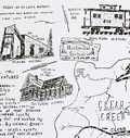 | Details | Morse, Russell A. | 1969 |
| Rusty's historical map of Clear Creek and Gilpin Counties Colorado pictorial |
|
Morse, Russell A. |
|
| 1969 |
| LOC:10 |
| $325.00 | Morse--Russell-A- | Rusty-s-historical-map-of-Clear-Creek-and-Gilpin-Counties-Colorado-pictorial | An original 1969 example of the first historical pictorial map produced by Rusty's Maps: Clear Creek and Gilpin Counties, Colorado. Small icons are used to represent key locations related to mining, railroads, and cultural history of those two counties. Important locations included the Argentine Pass, Silver Plume, Georgetown, Idaho Springs, East Portal, and Idaho Springs, Colorado and many more.
<br><br>
Measures 17 3/8" x 22 3/8" as called for as the 1969 first edition of 1000 on white offset stock. [1]. Published January 24, 1969.
<br><br>
Russell A. Morse (Rusty's Maps) began in 1969 with the publication of five historical maps that reflected Rusty's interest in old Ghost Towns: (1) Clear Creek and Gilpin Counties; (2) Western San Juan's; (3) Boulder-Estes Region; (4) Teller and West El Paso Counties, Colorado; (5) Summit and East Eagle Counties, Colorado. Though most prolific in the 1970's and 1980's, Rusty continued publishing maps and posters into the 1990s with a series for the National Western Stock Show and several posters of Colorado Gold Mining Regions.
<br></br>
[1] Online. 1669-1999. Listing of Rusty's Maps and related publications. https://rustysmaps.com/ |
| 5429 | 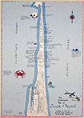 | Details | Price, Matthew | 1983 |
| Historical Map of Duck and Beyond |
|
Price, Matthew |
|
| 1983 |
| LOC:200 |
| $155.00 | Price--Matthew | Historical-Map-of-Duck-and-Beyond | Pictorial map of Currituck Sound, the Atlantic Ocean and the Outer Banks in the vicinity of Duck, Dare County, North Carolina. Created by Matthew Price in 1983.
<br></br>
This "Historical Map of Duck and Beyond" is decorated with scenes typical to the area near Duck, North Carolina (past and present): crabs, whales, wild flowers, shipwrecks, and ducks.
<br></br>
Price shows the street network and notes many points of interest on that narrow strip of land in the Outer Banks including:
<div class="indenttextblocksingle">
<ul style="list-style-type: circle;">
<li>Old Navy bombing range (no bombing allowed during hunting season).</li>
<li>Powder Ridge Gun Club</li>
<li>Caffey's inlet station</li>
<li>Maurice and Bea's Decoy Shops</li>
<li>Home and duck shop of "Pop" Scarborough</li>
<li>Ocean Beach campground</li>
<li>Duck Woods Golf Course</li>
<li>Old site of Martin's Point Club</li>
<li>Carolina Dunes</li>
</ul>
</div> |
| 5420 |  | Details | Maury, Matthew Fontaine | 1972 |
| Maurys Whale Chart 5th Edition |
|
Maury, Matthew Fontaine |
|
| 1972 |
| LOC:0 |
| $1,500.00 | Maury--Matthew-Fontaine | Maurys-Whale-Chart-5th-Edition | Scarce official U.S. thematic chart of reported whale sightings by geographic area, whale species, and relative number of sightings (5th ed. ca. 1972). An early example of the graphical display of quantitative information for decision making. The chart shows the best whaling areas and migration patterns for sperm whales and right whales, as well as the most densely populated areas of "Straggling" Sperm Whales and Right Whales." Chart # 5018.
<br></br>
Matthew Maury's Whale Chart, was first issued by the United States Bureau of Ordnance & Hydrography in 1851. This is the official U.S. fifth (5th.) edition, from the United States Defense Mapping Agency Hydrographic/Topographic Center in the 1970s. The DMA existed from 1972 through 1996. The first edition of Maury's Whale Chart is extremely rare on the market. Only one sale of Maury's chart is recorded in the Antique Map Price Record.
<br/></br/>
The last three editions of Maury's Whale Chart may be identified thus:
<div class="indenttextblocksingle">
<ul style="list-style-type: circle;">
<li><b>Third Edition (1956)</b></br>
Upper top left position with logo of eagle clutching items in claws surrounded by text: "Hydrographic Office U.S. Navy". Top right position is blank. Bottom right position reads "Price 20 cents / H.O. Miscel. No. 8514".</li>
<li><b>Fourth edition (1960)</b></br>
Upper top left position with logo of eagle over an anchor surrounded by text: "United States Hydrographical Office". Top right position reads "Catalog: Introduction. Part 1.". Bottom right position reads "Price 50 cents / H.O. Miscel. No. 8514" .
</li>
<li><b>Fifth edition (after 1972)</b></br>
Upper top left with logo containing an eagle perched on a globe with text "Defense Mapping Agency". Top right position reads "Catalog P2V10". Bottom right reads "Lith of Wm. Endicott & Co. N. York | 5018 | DMA Stock Number | W0XZC5018.</li>
</ul>
</div> |
| 5419 |  | Details | McLaughlin, James F. | 1939 |
| Tercentary Map of Barnstable Massachusetts |
|
McLaughlin, James F. |
|
| 1939 |
| LOC:53 |
| $295.00 | McLaughlin--James-F- | Tercentary-Map-of-Barnstable-Massachusetts | Scarce copy of the Tercentary Map of Barnstable, Massachusetts a pictorial map designed and drawn by James F. Mc Laughlin, Hyannis. Published in 1939. Tables at top left show members of the tercentenary committee (McLaughlin was Chairman) and a list of some of the first Non-Native American settlers in the region.
<br></br>
Contains native American place names such as Skonkonet, Wequaquet, Santuit, and Moskeehtickgut.
Includes the seal of the town of Barnstable, Mass and below, two small circular inset maps: "Old England" and "New England."
<br></br>
WorldCat list only two institutional holdings of this Tercentary Map of Barnstable, Massachusetts.
<br></br> |
| 5393 |  | Details | Anonymous | 1930 |
| Fragments of a manuscript illustrated map of the Caucasus early oil industry |
|
Anonymous |
|
| 1930 |
| LOC:2 |
| $190.00 | Anonymous | Fragments-of-a-manuscript-illustrated-map-of-the-Caucasus-early-oil-industry | Fragments of a larger manuscript pictorial map ca. 1930 of the Soviet Caucasus with early oil industry views. The fragments feature inhabitants of the republics in traditional outfits, some views of the oil derricks and traditional "bazaar" (marketplaces). Illustration of oil derricks show them enclosed in a fabric-covered frame to protect the drilling equipment against the very harsh cold.
<br></br>
The first fragment features Tajik, Turkmen & Uzbek ASSR. The second fragment features Dagestan ASSR, Kabardino-Balkar ASSR, Transcaucasian SFSR and other autonomous republics.
<br></br>
Attributed to a GIZ / IZOGIZ State design bureau worker. Izogiz was the fine arts section of Ogiz publishing. Ink, pencil, gouache on paper. |
| 5385 |  | Details | British Information Services | 1942 |
| Fine pictorial WWII-era map of the British Commonwealth of Nations |
|
British Information Services |
|
| 1942 |
| LOC: |
| $300.00 | British-Information-Services | Fine-pictorial-WWII-era-map-of-the-British-Commonwealth-of-Nations | Fine pictorial world map showing the British Commonwealth of Nations. Issued during WWII by the British Information Services, an agency of the British Government. Mercator projection.
<br></br>
Includes two inset tables:<br>
1) "Forms of Government". This key uses color to signify the form of government administration and management of internal and external affairs. <br>
2) "Principal Products". A tabular representation by geographical area uses pictograms to represent the most valuable products produced in the Commonwealth.
<br></br>
Distributed by the British Information Services, an agency of the British Government, 30 Rockefeller Plaza, New York. Printed in England. |
| 5381 |  | Details | Smith Kline and French | 1962 |
| Thematic map of the USA allergy season by state |
|
Smith Kline and French |
|
| 1962 |
| LOC:88 |
| $220.00 | Smith-Kline-and-French | Thematic-map-of-the-USA-allergy-season-by-state | Decorative thematic advertising map of the continental United States showing the months during which three types of pollen are prevalent. The map, by Smith, Kline, and French Laboratories (SKF) was created to support sales of Teldrin Spansules, SKF's brand name for chlorpheniramine maleate, an antihistamine. This mid 20th-century map shows the pollen season for grass pollen, tree pollen, and ragweed pollen.
<br></br>
Philadelphia. October 1962. |
| 5375 |  | Details | Louisville and Nashville Railroad | 1886 |
| Birds Eye View of Gulf Coast Louisville and Nashville Railroad |
|
Louisville and Nashville Railroad |
|
| 1886 |
| LOC: |
| $725.00 | Louisville-and-Nashville-Railroad | Birds-Eye-View-of-Gulf-Coast-Louisville-and-Nashville-Railroad | </br>"The Great Through Car Line Between the North and South."</br>
"Unrivaled in Speed, Construction and Equipment."
<br></br>
Fine bird's eye view of the central Gulf Coast highlighting the route of the Louisville and Nashville Railroad from Mobile, Alabama, through Mississippi, to New Orleans, Louisiana. The route includes Bay St. Louis, Ocean Springs, Pass Christian, Mississippi City, Biloxi, Pascagoula. Numerous steam-powered and wind-powered vessels are shown plying the waters of the Gulf of Mexico, Lake Ponchartrain and the Mississippi River.
<br></br>
Six-panel folding map, neatly folded inside a 64-page pamphlet (4.5 " x 7.25") titled "The Gulf Coast". With the ink stamp of Sam. B. Jones, General Agent, New York. Published by the passenger department of the Louisville and Nashville R.R.
<br></br>
Printed in Louisville, KY by the Press of the Courier-Journal Job Printing Company. |
| 5376 | 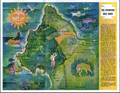 | Details | Runyan and Whitman | 1966 |
| Mid-century map of the Seventeen Mile Drive Carmel, Monterey golf |
|
Runyan and Whitman |
|
| 1966 |
| LOC:13 |
| $135.00 | Runyan-and-Whitman | Mid-century-map-of-the-Seventeen-Mile-Drive-Carmel--Monterey-golf | A perfect gift for the golfer! Fine pictorial map of the Seventeen Mile Drive snaking along Monterey Peninsula in California. Features found on this colorful map include Carmel, the Navy school in Monterey, Del Monte Shopping Center, Coast Highway No. 1, and the Pebble Beach Gun Club.
<br></br>
Verso contains descriptions of twenty-two numbered locations identified on the map including The Monterey Peninsula Country Club, Spanish Bay, Cypress Point, Crocker Grove, and the Pebble Beach Golf Links.
<br></br>
Date of the artifact is based on the fact that the brochure refers to the Spyglass Hill Golf Course as "A new 18 hole course". The Spyglass Hill course, designed by Robert Trent Jones Sr., opened in Pebble Beach during March 1966. |
| 5357 |  | Details | Grimes, George | 1944 |
| Pictorial map of Lowry Field Denver Colorado |
|
Grimes, George |
|
| 1944 |
| LOC:77 |
| $275.00 | Grimes--George | Pictorial-map-of-Lowry-Field-Denver-Colorado | A very scarce pictorial map of Lowry Field, at the eastern edge of Denver, Colorado, from the first issue of the Lowry Field Information Handbook [1] in November, 1944. Lowry field was activated in February, 1938 as the site of the Army Air Forces Training Command [2]. From the 1980’s, Lowry Air Force Base was one of Colorado’s largest employers. Lowry AFB employed nearly 10,000 military and civilian men and women, providing an economic impact annually approaching $1 billion [3].
<br></br>
<div class="indenttextblocksingle">
[1] Earliest publication was November, 1944 with a later edition of February, 1945. On the later map a telephone icon is added and locations of the telephone shelter house and telephone lounges are colored orange.<br>
[2] Information Handbook Lowry Field (AAF Training Command). Mountain States Telephone and Telegraph Company. Denver. 1944. Online.<br>
[3] https://wingsmuseum.org/about/history/. Online
</div> |
| 5346 | 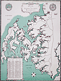 | Details | Kellogg, Charles W. | 1960 |
| Pictorial Map of Seats on Talbot County Waterways |
|
Kellogg, Charles W. |
|
| 1960 |
| LOC:53 |
| $480.00 | Kellogg--Charles-W- | Pictorial-Map-of-Seats-on-Talbot-County-Waterways | Scarce pictorial thematic map with more than 80 historic estates (seats) near Chesapeake Bay in Talbot County, Maryland. Each estate is numbered and keyed to a list with the names of their owners. Small elevation drawings of each estate provide a rough idea of how the estate looked in 1960. The map includes some old historic points of interest in Talbot County such as the old Wye Church and Friends Meeting House.
<br></br>
The large waterways shown on this estate map include the Wye River, Miles River, Harris Creek, Broad Creek, Tred Avon River, and Choptank River. Smaller waterways include among others, Goldsborough Creek, Leeds Creek, Island Creek, and Trappe's Creek. Towns in Talbot County include St. Michaels, Easton, Oxford, Queen Anne, and Trappe.
<br></br>
Map Title: "Seats on Talbot County Waterways Chesapeake Bay." By Charles W. Kellogg. Updated edition from 1960 of a map that Kellogg first published in 1949. Charles Kellogg's own estate on Skipton Creek, numbered as #1 was "Langshaws".
<br></br>
Several of the seats listed in Talbot County in 1960 are found today in the National Register of Historic Places.
<div class="indenttextblocksingle">
<ul style="list-style-type: circle;">
<li>The Anchorage: Easton. Robert L. Kemp</li>
<li>Compton: Trappe. Charles F.C. Arensberg</li>
<li>Otwell: Oxford. J. E. Jackson</li>
<li>Troth's Fortune: Easton. Frederick S. Thomas</li>
<li>Wye House. Easton. Morgan B. Schiller</li>
</ul>
</div> |
| 5258 |  | Details | Goodrich, James J. | 1930 |
| Unrecorded Panoramic Pictorial Map of Panama |
|
Goodrich, James J. |
|
| 1930 |
| LOC:77 |
| $275.00 | Goodrich--James-J- | Unrecorded-Panoramic-Pictorial-Map-of-Panama | Unrecorded pictorial map of Panama by Corporal James J. Goodrich, 11th Engineers ca. 1930. Adorned with numerous idiosyncratic illustrations including at upper right a drawing of a panther labeled "Black Cats." Many illustrations of military aircraft and naval vessels. Dotted line north of the Panama Canal shows a "proposed highway across the isthmus" beginning at the Madden Dam, completed in 1935, and terminating at Colon on the Pacific Ocean.
<br></br>
The 11th Engineer battalion was activated on the 20th of November, 1920 in the Panama Canal Zone. The 11th engineers conducted numerous engineer missions over rugged terrain and through dense jungle. It was in Panama that the 11th adopted for its crest the Panama Black Panther and assumed the nickname "Jungle Cats." The 11th Engineers were relieved of their assignment to the Panama Canal Division in April, 1932. |
| 5260 |  | Details | Stanton, Jeffrey | 1979 |
| Large pictorial map of Venice, California |
|
Stanton, Jeffrey |
|
| 1979 |
| LOC:53 |
| $375.00 | Stanton--Jeffrey | Large-pictorial-map-of-Venice--California | Large and amusing pictorial map of Venice, California by Jeffrey Stanton, businessman and artist. First edition.
<br></br>
Copyright 1979. Artwork by C. June Barton and R. Greenway Frager. |
| 5255 |  | Details | Anonymous | 1958 |
| Pictorial Map of Sanlando Springs attraction near Longwood, Florida |
|
Anonymous |
|
| 1958 |
| LOC: |
| $125.00 | Anonymous | Pictorial-Map-of-Sanlando-Springs-attraction-near-Longwood--Florida | Colorful pictorial map of the Sanlando Springs tourist attraction in Central Florida. Map is surrounded with drawings of family-oriented activities available at Sanlando: Jungle Cruise, outdoor cooking, dancing on the patio. Based on the postal rate of 3 cents this item probably dates to the late 1950's. Folding map, verso with space for a stamp and address as well as a pre-written letter in script touting the many things to do at Sanlando.
<br></br>
Sanlando Springs, along with nearby Rock Springs, Wekiwa Springs and Palm Springs, form the headwaters of the Wekiva River.
<br></br>
The spring, originally Hoosier Springs, was used for recreation as far back as the 1880's. The location was renamed as Sanlando by Altamonte Mayor J.F. Haithcox who developed the location as an amusement park in the 1920's. (Source: https://studiohourglass.blogspot.com/2013/06/giving-new-life-to-sanlando-springs.html). |
| 5253 | 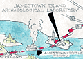 | Details | James River Ceramics Club | 1951 |
| Jamestown James River Ceramics Club Field Trip |
|
James River Ceramics Club |
|
| 1951 |
| LOC: |
| $350.00 | James-River-Ceramics-Club | Jamestown-James-River-Ceramics-Club-Field-Trip | Unrecorded and hand-colored pictorial route map for the James River Ceramics Club. Mid 20th-century birds-eye perspective map of the area surrounding the James River near Jamestown, Virginia, location of the first permanent English settlement in North America.
<br></br>
Made for the occasion of the first annual field trip of the James River Ceramics Club to the Jamestown Island Archaeological Laboratory and to James O'Donnell Pottery on Sunday, August 12, 1951. Shows the towns of Williamsburg, Hilton Village, Benn's Church, Bacon's Castle, Surry, Burrowsville and more. With the logo for the James River Ceramics Club. |
| 5251 |  | Details | Hutson, H.H. | 1948 |
| Humorous map of the world from a Texans perspective |
|
Hutson, H.H. |
|
| 1948 |
| LOC:200 |
| $125.00 | Hutson--H-H- | Humorous-map-of-the-world-from-a-Texans-perspective | A humorous map of the world explained by pictorial illustrations related to Texas features and exaggerations. Distributed as a paper placemat for Long Champ restaurant in Amarillo, Texas - Homer Rice, Owner. Copyright 1948 by H.H. Hutson. Only one recent sale recorded, scarce. |
| 5200 | 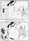 | Details | Army Bureau of Current Affairs | 1945 |
| Wartime pictorial maps one week after A-bombs on Japan |
|
Army Bureau of Current Affairs |
|
| 1945 |
| LOC:62 |
| $475.00 | Army-Bureau-of-Current-Affairs | Wartime-pictorial-maps-one-week-after-A-bombs-on-Japan | Large wartime pictorial poster issued less than one week after the United States used nuclear weapons on Hiroshima and Nagasaki, Japan. This issue, with a heavy emphasis on use of maps to communicate the progress of the war, was the first such to be issued by the [British] Army Bureau of Current Affairs (ABCA) after the United States dropped atomic bombs on Hiroshima and Nagasaki on August 6 and 9 respectively. The issue was published 3 days before Emperor Hirohito announced the total Japanese surrender on national radio.
<br></br>
The maps reflect the importance of the A-bomb to Allied war efforts and the hastiness with which this publication was revised before publication. No photographs or illustrations are present that show the mushroom cloud or the aftermath of the attacks. The verso contains text that does not reflect the news about the bomb: " … the counter invasion of this island empire [East Indies] has begun."
<br></br>
Printed on both sides:
<div class="indenttextblocksingle">
<ul style="list-style-type: circle;">
<li><b>Recto:</b> Headings include "The close of 14 years of Jap aggression" with six inset pictorial maps charting Japanese aggression from 1933 to 1945. Japan's early successes and later defeat are reflected in the image of a sword-bearing Japanese soldier who grows fat with success and then thin with defeat. Also, photographs of the British Cabinet and news from the Potsdam conference.</li>
<li><b>Verso:</b> "Riches of the Southern Seas". Large black and white pictorial map focused on the strategic value of key commodities in the Netherlands East Indies. Map contains pictograms for oil, rubber, rice, tin, and vegetable oils. </li>
</ul>
</div>
ABCA MAP Review No. 72 From July 30th to August 12th, 1945. Drawn and issued by the Army Bureau of Current Affairs. Printed for H.M. Stationery Office by Fosh & Cross Ltd., [1945]
<br></br>
No copies of this issue found online. Scarce. |
| 5095 | 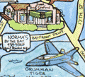 | Details | Gulf Coast Impressions | 1996 |
| 50th anniversary poster map Pensacola Blue Angels |
|
Gulf Coast Impressions |
|
| 1996 |
| LOC:87 |
| $145.00 | Gulf-Coast-Impressions | 50th-anniversary-poster-map-Pensacola-Blue-Angels | Pictorial poster map of Pensacola, Florida printed for the 50th Anniversary of The Navy Blue Angels Precision Flying Squadron. With advertising for local businesses. Glossy paper.
<br></br>
The Blue Angels were formed in 1946 under the leadership of Admiral Chester Nimitz to increase public interest in naval aviation. Since 1955 the Blue Angels have made Forrest Sherman Field, Naval Air Station Pensacola, Florida their home base during the air show season. |
| 5097 |  | Details | Withers, James Harlan | 1958 |
| A Texan's Map of U.S.A. |
|
Withers, James Harlan |
|
| 1958 |
| LOC:0 |
| $500.00 | Withers--James-Harlan | A-Texan-s-Map-of-U-S-A- | A Texan's Map of U.S.A. A derivative edition of a classic pictorial "humorous" map with more than a whiff of the intolerance that some believe permeates the state of Texas today. Tablecloth-sized map of the United States on Indian Head cloth [1] based on a design copyrighted by J.H. Withers in 1947 and branded with the imprint of Lackland Air Force Base in San Antonio, Texas.
<br></br>
Wither's distinctive design elements include a revised shape for Texas which extends to the west coast to provide Texas with a space for a "future seaport" and the appellation "damm' Yankee territory" for most of the northeast U.S.A.
<br></br>
The Catalog of Copyright Entries for 1947 records a copyright for "A Texan's Map of U.S.A.", held by James Harlan Withers of San Angelo, Texas. Wither's 1947 pictorial map is the earliest documented example of a genre of pictorial map with many derivative versions that begin with the fact that Texas was, at the time, the largest state in the U.S. and extend that simple premise to exaggerate the importance and quality of the state of Texas over the every other state in the U.S.A.
<br></br>
Early 50's date is supported by the fact that neither Alaska nor Hawaii, which both attained statehood in 1959, are mentioned on the map.
<br></br>
[1] Indian Head cloth was not manufactured after 1962. Indian Head Cloth Permanent Finish Sanforized stamping on a single line is associated with cloth produced from the late 1940s to early 1950s. (Source: http://info.fabrics.net/indian-head-remembered-revisiting-an-american-institution/) |
| 5085 | 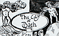 | Details | Anonymous | 1970 |
| Manuscript copy of the map City of Bath after Joseph Gilmore |
|
Anonymous |
|
| 1970 |
| LOC:200 |
| $450.00 | Anonymous | Manuscript-copy-of-the-map-City-of-Bath-after-Joseph-Gilmore | Manuscript pen and ink (hand drawn) map of the City of Bath, England after an earlier map by Joseph Gilmore in 1731. On heavy paper. Likely mid-20th century. Differs from Gilmore's original map of Bath in that fewer buildings are shown on the border of the map.
<br></br>
Gilmore's original elaborate map of the city of Bath shows Bath still largely contained within its medieval walls. The map indicates the growing popularity of Bath as a destination for visitors in the early 18th century. Around the border of Gilmore's map are views of 36 lodging houses or other public buildings. The map was reissued 6 times between 1694 and 1731. |
| 5076 | 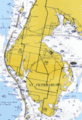 | Details | Smiley, Russ | 1987 |
| Russ Smiley's Fishing-Boating Map Cape Sable to Crystal River |
|
Smiley, Russ |
|
| 1987 |
| LOC: |
| $175.00 | Smiley--Russ | Russ-Smiley-s-Fishing-Boating-Map-Cape-Sable-to-Crystal-River | Late 1980's chart of the Everglades, South Florida, and the Florida Keys surrounded by Smiley's illustrations of colorful fishes. Chart is overprinted with dots representing hot fishing spots and with the names of the fishes that might be caught in an area.
<br></br>
Created and published by Miami, Florida artist Russ Smiley. Last copyright is from 1979 by Russ Smiley. Purchased as new old stock. Published by Windward Publishing, Miami.
<br></br>
Verso with illustrations of south Florida fishes, fishing techniques, and baits. |
| 5040 |  | Details | H. R. Elliot and Co. Inc. | 1937 |
| Map of Bermuda Merrily we go around |
|
H. R. Elliot and Co. Inc. |
|
| 1937 |
| LOC:10 |
| $175.00 | H--R--Elliot-and-Co--Inc- | Map-of-Bermuda-Merrily-we-go-around | Cute pictorial map of Bermuda: "Merrily we go around. " Four panel brochure with an Illustration of a train and a pirate are featured next to the title cartouche. Verso with advertisements. Not dated but ca. 1937.
<br></br>
Published and printed by H. R. Elliot and Co. Inc., New York, N. Y. Provided courtesy of Bermuda. Size within the neatline 17" W x 7 H. |
| 5024 |  | Details | Borrego Springs Land and Development Company | 1953 |
| Scarce Borrego Springs California Sales Map |
|
Borrego Springs Land and Development Company |
|
| 1953 |
| LOC:400 |
| $550.00 | Borrego-Springs-Land-and-Development-Company | Scarce-Borrego-Springs-California-Sales-Map | Scarce tract map of lots for sale in Borrego Springs, California ca. 1953 before construction was completed on the Catholic Church. With an inset smaller-scale humorous pictorial map of the region around Borrego Springs, in San Diego County.
<br></br>
Today Borrego Springs is designated as a Dark Sky Community, the only community in California with that designation and one of only 22 locations in the world to have the designation. Not dated, not attributed. |
| 4984 | 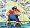 | Details | West Coast Airlines | 1954 |
| Pictorial Map of Washington State by West Coast Airlines |
|
West Coast Airlines |
|
| 1954 |
| LOC:88 |
| $300.00 | West-Coast-Airlines | Pictorial-Map-of-Washington-State-by-West-Coast-Airlines | Scarce, colorful, pictorial map of airline routes across Washington, Oregon, and Idaho flown by West Coast Airlines. Statement at bottom of the map reads: "Paul Bunyan's Empire Cut to Travel Size".
<br></br>
West Coast Airlines (WCA), founded in 1941, was based at Boeing Field in Seattle. WCA began scheduled passenger service in 1946 with a fleet of Douglas DC-3s. Table at upper right contains a list of Key Points of Interest across the three-state area. Dated within at 1954. Verso with text and photo images from across the region.
<br></br>
Apparently the map was updated and re-issued again in 1962. |
| 4971 | 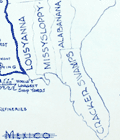 | Details | Withers, James Harlan | 1947 |
| Humorous map of Texas from a Texan perspective |
|
Withers, James Harlan |
|
| 1947 |
| LOC:63 |
| $700.00 | Withers--James-Harlan | Humorous-map-of-Texas-from-a-Texan-perspective | Scarce original blue-line, politically incorrect, map of the state of Texas from the 'humorously' distorted perspective of a Texan looking outward at the rest of the country. Believed to be the earliest recorded version of later similar 'humorous' maps of Texas inspired by Wither's design. Only one holding is found online, at the University of Texas, Arlington, where it is described:
<div class="indenttextblocksingle">
Map shows distortion of boundaries of the state of Texas in comparison to its U.S. neighbors with humorous bragging and derogatory relabeling. Relief shown by hachures. (Source: https://texashistory.unt.edu/ark:/67531/metapth252139/)
</div>
<br></br>
The Catalog of Copyright Entries for 1947 records a copyright for "A Texan's Map of U.S.A.", held by James Harlan Withers of San Angelo , Texas. Predates by two years the derivative but substantially different "A Texan's Map of the United States" by Frank Oliver published in 1949 for TexOak flooring.
<br></br>
The blue-line, or diazo process is a chemical method of document reproduction that fell out of use in the early 2000's. |
| 4948 |  | Details | City of Elizabeth, New Jersey | 1860 |
| Broadside for Rising Sun Property Elizabethport, NJ. |
|
City of Elizabeth, New Jersey |
|
| 1860 |
| LOC:53 |
| $800.00 | City-of-Elizabeth--New-Jersey | Broadside-for-Rising-Sun-Property-Elizabethport--NJ- | Rare lithographed broadside for a Sheriff's sale of the Rising Sun Property, consisting of 1000 lots in Elizabethport, New Jersey along the Elizabeth River (13 miles SW of Lower Manhattan). The land for sale is apparently the Rising Sun Farm, one of Thomas Gibbon's extensive land holdings in New Jersey. Gibbons was an early employer and partner with Cornelius Vanderbilt.
<br></br>
Quite a bit of land to the north of the Rising Sun tract is associated with Captain J.S. Spencer. Captain John Smythe Spencer (1745-1826), son of Colonel Thomas Spencer, was a British Army officer who lived in Elizabeth, New Jersey at an estate aptly named "Edgemoor". Spencer married Julia Radcliffe who produced two children: John Cotton Smith Spencer and Maria Spencer.
<br></br>
Two sailing vessels are shown plying the waters of Elizabethtown Creek; significant in that neither ship shows any evidence of steam power.
<br></br>
Streets named include: Atlantic, Baltic, Caspian, Delaware, Erie , Florida, Geneva ,Second, Butler, Smith, First, and Water Street. Avenues named include: Fourth, Third , Second, First, and Elizabeth Avenue.
<br></br>
Noted points of interest include: Old Point Road, Elizabethtown Creek, J. C. Fairbank & Company Rope Walk, Staten Island Sound, Whitmore & Jones Wheel Factory, Eagle Hotel, Price's Creek, Elizabethport & New York Ferry Dock, Voorhees and Bacon's Coal Yard, and the C. H. Waterbury Oil Manufactory.
<br></br>
Lithographed by William Faust, 59 Fulton Street, New York. An 1860 entry for Faust in Trow's New York City Directory lists his address as 59 Fulton Street. Stamped by James S. Vosseller. Purchased from a lot of similar Voseller surveys and sales broadsides dated 1857 - 1874.
<br></br>
The City of Elizabeth, N.J. was created in March, 1855 combining and replacing both Elizabeth Township and Elizabeth Borough. With the creation of the City of Elizabeth, Elizabeth Township was dissolved. |
| 4861 |  | Details | Edwards, Ham | 1929 |
| Antique Map Catalina Island, California Depression-era |
|
Edwards, Ham |
|
| 1929 |
| LOC:13 |
| $150.00 | Edwards--Ham | Antique-Map-Catalina-Island--California-Depression-era | Fine pre-depression-era brochure with a bright pictorial map of Catalina Island in the Pacific Ocean, off the coast of Long Beach, California. Published by Wilmington Transportation Company who offered steamer services from the Catalina Steamer Terminal to Catalina Island from Los Angeles, Long Beach, and Pasadena.
<br></br>
Included in a six-page brochure with things to do, rates for trips and ferry service, photographs, and advertisements for local hotels including the "Largest one floor hotel in the world with 1250 rooms." Map predates the Great Crash of October 1929 by three months.
<br></br>
Drawn by "Ham" Edwards - Art Services. |
| 4769 |  | Details | Societa Partenopea di Navigazione | 1970 |
| Pictorial map of Amalfi Coast and Bay of Naples. |
|
Societa Partenopea di Navigazione |
|
| 1970 |
| LOC:0 |
| $35.00 | Societa-Partenopea-di-Navigazione | Pictorial-map-of-Amalfi-Coast-and-Bay-of-Naples- | Decorative pictorial map of the Bay of Naples and Amalfi Coast area in Italy ca. 1970. Includes the islands of Capri, Ischia, and Procida linked with mainland towns of Pozzuoli, Napoli, Sorrento, Positano, and Amalfi.
<br></br>
This colorful small map was published by the Italian transportation service SPAN, the Societa Partenopea di Navigazione. Art by Cassese. With the SPAN flag and the phrase "con la SPAN verso mete felici" or Google-translated from Italian as "with SPAN towards happy destinations."
<br></br>
Verso with a complete SPAN timetable in English. |
| 4767 | 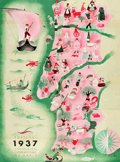 | Details | Botelho, Carlos | 1937 |
| Portugal 1937 Exposition Internationale de Paris |
|
Botelho, Carlos |
|
| 1937 |
| LOC:88 |
| $400.00 | Botelho--Carlos | Portugal-1937-Exposition-Internationale-de-Paris | Very fine map of Portugal in a simple, folksy, pictorial style. For a brochure "Portugal Gastronomique" to support the Portuguese exhibit at the 1937 International Exhibition of Arts and Techniques in Paris, France May 4 to November 27, 1937. There, pavilions of the participating countries were built along the Seine. These structures were projects by the outstanding architects of the time.
<br></br>
On the recto French text written by Albino Forjaz Sampaio and simple images related to traditional Portuguese food.
(Source: http://garfadasonline.blogspot.com/2013/04/portugal-gastronomico-na-exposicao-de.html
<br></br>
Signed within as "Botelho 37". Carlos Botelho (1899-1982) was a multi-faceted artist, illustrator, and caricaturist. Lito National - Porto. |
| 4733 |  | Details | Asahi Shimbun | 1926 |
| Fine Japanese inter war sugoroku biplane flight game board |
|
Asahi Shimbun |
|
| 1926 |
| LOC:0 |
| $165.00 | Asahi-Shimbun | Fine-Japanese-inter-war-sugoroku-biplane-flight-game-board | Very attractive and decorative Japanese Taisho period inter-war sugoroku board game with pictures of biplanes. This large sugoroku commemorates a record long flight to Europe in July 1925 via the route of Tokyo-Paris-London. The flight, with two Breguet 19 A2 biplanes, was sponsored by the Asahi Shimbun newspaper and piloted by H. Abe and K. Kawachi, covering 13,800 km (8,575 mi).
<div class="indenttextblock">
The Bréguet XIX was two-seater light bomber and as a reconnaissance aircraft, first rolled out in 1923. A very successful metal biplane, it stayed in operational service for fifteen years.
(Source Online: http://acepilots.com/pioneer/breguet19.html)
</div>
</BR>
Set across a background of Asia, locations on the board correspond to cities in Asia and Europe to include Rome, London, Paris, Istanbul and many more. Text in Japanese. Verso is blank.
<br></br>
E-sugoroku, with rules similar to the game of chutes and ladders, appeared in Japan as late 13th century and became popular due to the cheap and elaborate wooden block printing technology of the Edo period. Sugoroku boards were made with pictures and themes from religion, political, actors, heroes, and popular culture. |
| 1418 |  | Details | Johst, Paul Spener | 1931 |
| California Pictorial Map |
|
Johst, Paul Spener |
|
| 1931 |
| LOC:20 |
| $85.00 | Johst--Paul-Spener | California-Pictorial-Map | Pictorial map of the State of California in a cartoon-like style. Depicts transportation, chief industries (film-making, asparagus farming), nature, and recreations for the state in an exaggerated, stereotyped manner. Legend identifies 5 locations within California: Yosemite National Park, San Francissco, Oakland, Los Angeles, and San Diego. Catalina Island is identified by name. Page 181.
<br></br>
Verso with text extolling the virtues of California's natural wonders and its agriculture.
<br></br>
From "Picture Map Geography of the United States" by Vernon Quinn. With Picture Maps by Paul Spener Johst. Publisher: Frederick A. Stokes Company. New York. 1931. Some picture maps in the book contain depictions that today might be considered politically incorrect or even racist. |
| 1419 |  | Details | Johst, Paul Spener | 1931 |
| Alaska Pictorial Map |
|
Johst, Paul Spener |
|
| 1931 |
| LOC:41 |
| $85.00 | Johst--Paul-Spener | Alaska-Pictorial-Map | Pictorial map of the State of Alaska in a cartoon-like style. Depicts transportation (dog sledding) , nature (bears and igloos) and recreations for Alaska in an exaggerated, stereotyped manner. Legend identifies four locations within Alaska: Juneau, Ketchikan, Anchorage, and Wrangell. Kodiak Island, British Columbia and the Yukon are identified by name. Page 193.
<br></br>
Verso with text extolling the virtues of Alaska's natural wonders and its mountains; and bears.
<br></br>
From "Picture Map Geography of the United States" by Vernon Quinn. With Picture Maps by Paul Spener Johst. Publisher: Frederick A. Stokes Company. New York. 1931. Some picture maps in the book contain depictions that today might be considered politically incorrect or even racist. |
| 1421 |  | Details | Johst, Paul Spener | 1931 |
| South Carolina Pictorial Map |
|
Johst, Paul Spener |
|
| 1931 |
| LOC:41 |
| $85.00 | Johst--Paul-Spener | South-Carolina-Pictorial-Map | Pictorial map of the State of South Carolina in a cartoon-like style. Depicts transportation (mules), agriculture (tobacco, rice, watermelon, cotton, corn) for the State of South Carolina in an exaggerated, stereotyped manner. A decorative legend at bottom left identifies four locations within South Carolina: Charleston, Columbia, Greenville, and Spartanburg. Page 57.
<br></br>
Verso with text extolling the virtues of South Carolina geography and natural wonders.
<br></br>
From "Picture Map Geography of the United States" by Vernon Quinn. With Picture Maps by Paul Spener Johst. Publisher: Frederick A. Stokes Company. New York. 1931. Some picture maps in the book contain depictions that today might be considered politically incorrect or even racist. |
| 1377 |  | Details | Pennsylvania Railroad | 1885 |
| Early Pictorial Map of New Jersey Ocean Resorts and Railroads |
|
Pennsylvania Railroad |
|
| 1885 |
| LOC:0 |
| $190.00 | Pennsylvania-Railroad | Early-Pictorial-Map-of-New-Jersey-Ocean-Resorts-and-Railroads | Interesting map evoking seaside dreams of an earlier age at the Jersey shore.
<br></br>
Matted and framed pictorial map from 1885 to accompany the Pennsylvania Railroad Summer Excursion routes publication. Size with frame 17" x 21". This old survivor shows numerous resorts, beaches, parks, coast and bays covered with decorative ship traffic heading in every direction, most of the vessels under sail or sail with steam assist. Lithograph. Includes New York City at top, Coney Island, Asbury Park, Manasquan, Barnegat, Atlantic City, Cape May, Philadelphia, Delaware Bay and River and Rehoboth Beach at bottom. Very decorative. $45 packing and shipping.
<br></br>
Railroad lines shown include: the Camden and Atlantic Railroad, West Jersey Railroad, Pennsylvania Railroad, New York and Long Branch R.R., the Cumberland and Maurice Railroad and many more. Shows little trains of four or five commuter cars with a steam engine puffing along ahead. The age of steam! Great for the man cave. |
| 1371 |  | Details | Butler, Lowell | 1952 |
| Fine Baby-Boom Era Pictorial Map of California |
|
Butler, Lowell |
|
| 1952 |
| LOC:0 |
| $155.00 | Butler--Lowell | Fine-Baby-Boom-Era-Pictorial-Map-of-California | Large, attractive poster-size map of California's historical sites created during the post-war baby-boom era of the early 1950s. Numerous sites are numbered on the map. Includes extensive notations on the verso related to a whopping 496 sites in California. Cartography By Lowell Butler.
<br></br>
Verso contains textual descriptions related to the precise location and a brief history of each of the 496 sites.
A few examples of the sites include: <br><br/>
<hr>
<ul>
<li><strong>1-- Customs House. Alvarado, Main and Scott Streets, Monterrey.</strong><i> The port of entry for vessels and cargo reaching California during the days of Spanish and Mexican occupation...</i></li>
<li><strong>411-- Campo Store. Campo, San Diego County</strong><i> A frontier trading post and border fort built by Luman H. and Silas E. Gaskill who settled here in 1868.</i></li>
<li><strong>190-- Painted Rock. 7 miles southeast of Corona on State Highway No 71, Riverside County. </strong><i>A boulder with Indian pictographs applied (probably of Louiseno origin), registered and marked in 1927. What the pictographs mean has not been determined.
<hr></i></li>
</ul>
According to David Rumsey "The sites are identified by whether they are from the Spanish-Mexican Period, Years of the Gold Rush, Agricultural Era or Commercial and Industrial Expansion era. . With insets: San Francisco Bay; Monterey sites; Los Angeles and vicinity sites; San Diego sites; Mother lode sites. On verso: 'A note of explanation by Phil Townsend Hanna'; descriptive list of historical sites with color drawings, numbered to correspond with sites on map."
<br></br>
Compiled from the official registrations of the California State Department of Natural Resources. By Phil Townsend Hanna and William Webb. Copyright 1952 by the Automobile Club of Southern California. Published by Westways, Vol. 44, No. 12. |
| 1352 |  | Details | Bullard Company, The | 1916 |
| Huge road map of New England with early advertisements |
|
Bullard Company, The |
|
| 1916 |
| LOC:0 |
| $65.00 | Bullard-Company--The | Huge-road-map-of-New-England-with-early-advertisements | Large antique advertising-related 4' x 3' road map of south New England from the beginning of the age of automobile travel. Coverage extends from New York and Albany in the west to Cape Ann and Nantucket in the east. Includes Boston, Cape Cod, Martha's Vineyard, Block Island Sound, Rhode Island and Long Island Sound. Copyrighted 1916 by the Bullard Company, 44 Cornhill, Boston. A fine piece for the man-cave. (Yard-stick shown for size estimation, not included).
<br></br>
Inset advertising and related photographs and numerous closeup circular maps of key areas including: Fall River, Marblehead, New London, Concord, Plymouth, and Cape Cod. Overstamp reads: "Compliments of the Hotel Raymond. Fitchburg, Mass.".
<br></br>
Verso with advertisements and numerous tables of related information including distances and census data. Orginal envelope included. |
| 1136 |  | Details | Wilson, John F. | 1979 |
| Decorative pictorial map of Manteo, North Carolina |
|
Wilson, John F. |
|
| 1979 |
| LOC:52 |
| $225.00 | Wilson--John-F- | Decorative-pictorial-map-of-Manteo--North-Carolina | Interesting pictorial map of downtown Manteo, North Carolina on Roanoke Island along Shallowbag Bay. This very decorative map is packed with features of daily life on Roanoke and provides a street map and birds-eye view of Manteo downtown ringed by pictures reflecting its maritime heritage including boats, sea chests, seagulls, oars, antique furniture, anchors, and foodstuffs.
<br></br>
A number of local historical homes are featured including the George Howard Creef House; the Forbes Nixon House; the Meekins House; the James Bonner House; and "The Old House" or George Washington Creef House, said to be one of the oldest structures then standing in downtown Manteo. Other key features pictured on the map are the Pioneer Theater; the Roanoke Island Volunteer Fire Department; Water Oak at Mother Vineyard; and the Dare County Courthouse.
<br></br>
About the courthouse Wilson notes:
<div class="indenttextblock"> "Erected 1904, replacing a wooden 1873 structure. The land for the building was donated by John Wescott in 1870 when the county of Dare was formed from the counties of Hyde, Tyrrell and Currituck. It was named in honor of Virginia Dare, the first child of English parents born in the New World."
</div>
<br />
Manteo is located on Roanoke Island, part of North Carolina's Outer Banks. Named the seat of government for Dare County in 1870, Manteo incorporated in 1899 and in 2010 had a population of just 1434 persons.
<br></br>
Published by John F. Wilson IV in 1979. |
| 716 |  | Details | George W. Walker Lithograph and Publishing Co | 1907 |
| Boston Harbor and the North Shore |
|
George W. Walker Lithograph and Publishing Co |
|
| 1907 |
| LOC:0 |
| $260.00 | George-W--Walker-Lithograph-and-Publishing-Co | Boston-Harbor-and-the-North-Shore | Original antique birdseye view folding map of Boston Harbor by George Walker shows ferry routes, steamer routes and railroad lines between Boston and points both within Boston Harbor and to outlying towns. This fascinating old lithographed map differs from other birdseye-view maps we are aware of from this era because it includes Marblehead, Lynn, Salem and extends north-eastwards to Gloucester, Massachusetts. We can date the map with confidence because it clearly shows the Wonderland Amusement Park at Revere Beach which failed after five years, operating exclusively between 1906 and 1911. Wonderland, served by the Revere Beach and Lynn Railroad, was modeled along the lines of the World's Fairs of that era and included roller coasters, technological exhibits, theaters and a boardwalk.
<br></br>
Noted points of interest include Charlestown, Point of Pines, Magnolia, Baker's Island, Thompson's Island, "the Pumping Station", Dorchester Bay, Squantum, Norfolk Downs, Quincy Bay, Hough's Neck, Hingham Harbor, Winthrop, Beachmont, Great Head, Peddock's Island, Nantasket Beach, Port Allerton, the town of Hull with Fort Revere, George's Island with Fort Warren, Deer Island, Lovell's Island, Lynn, Swampscott, Thatcher's Island, Strawberry Hill, and many more. Captures several local lighthouses and aids to navigation including Boston Light, Long Island Light, Fawn Bar Beacon, Graves Light, and far out the bay - a whistling buoy.
<br></br>
Original lithograph by George W. Walker, lithographer of Boston in landscape format is in very good condition for a 105+ year old map. Was originally folded into a card cover but the front half has disappeared leaving the map attached to the back cover, as issued.
<br></br> |