| | Thumbnail | | Creator | Date | Title / Author / Date / Location | Price | | | Description |
| 2489 | 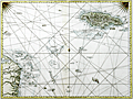 | Details | Jefferys, Thomas | 1775 |
| Antique Chart of The Island of Jamaica and Cape Gracias a Dios |
|
Jefferys, Thomas |
|
| 1775 |
| LOC:51 |
| $1,675.00 | Jefferys--Thomas | Antique-Chart-of-The-Island-of-Jamaica-and-Cape-Gracias-a-Dios | Fine antique sea chart covering from the Mosquito Coast (labeled Moskito King's Party) of Honduras and Nicaragua to Jamaica, a distance over water of more than 400 miles. First state chart with numerous navigational details such as depth soundings, reefs, and the prevailing current.
<br></br>
Includes ships' tracks labeled 'Galleons Track from Cartagena to Havana' that skirt numerous reefs on the dangerous voyage from Colombia to Cuba. These details are worthy of study under magnification for the insight they provide on the key success factors for seafarers in the mid-eighteenth century.
<div class="indenttextblock">
<ul style="list-style-type: circle;">
<li>South Key- "Fresh water under a large wild grape tree."</li>
<li>"Main Cape Reef and Keys by the Spaniards los Tiburones"</li>
<li>"Serrana alias The English Bank called also Pearl Island"</li>
<li>"Quinta el Sueno called by the baymen Guana Reef"</li>
<li>Southwest of Jamaica- "La Bivora or Pedro Shoals according to the surveys of Spanish pilots in 1727 and 1750"</li>
</ul>
</div>
From Sayer's and Bennett's atlas titled: The West-India Atlas: or, a compendious description of the West-Indies: illustrated with forty one correct charts and maps, taken from actual surveys."
<br></br>
Publishers attribution reads: "London. Printed for Rob.t Sayer, Map and Printseller. No 53 Fleet Street as the Act directs 20th Feb.y 1775. According to Rumsey <div class="indenttextblock">
"Sayer and Bennet acquired his [Jefferys'] materials in preparation for this atlas, and published the atlas posthumously under his name (as they did with the American Atlas) in 1775. The heart of this atlas and the most detailed part is the sixteen sheet large chart and index sheet of the whole of the West Indies. (
<a href="http://www.davidrumsey.com/luna/servlet/detail/RUMSEY~8~1~2795~310044:The-coast-of-Yucatan-from-Campeche-" target="_blank">Internet </a>)
</div> |
| 1450 | 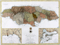 | Details | van Keulen, Gerard | 1775 |
| Jefferys Sayers Chart of Jamaica from West-India Atlas |
|
van Keulen, Gerard |
|
| 1775 |
| LOC:51 |
| $450.00 | van-Keulen--Gerard | Jefferys-Sayers-Chart-of-Jamaica-from-West-India-Atlas | Attractive, very desirable antique British chart of the Island of Jamaica in the Caribbean Sea by Thomas Jefferys. After surveys by Dutch cartographer Gerard Van Keulen.
<br></br>
This spectacular chart is from the scarce <b>first issue of The West-India Atlas, 1775 by Sayer</b>, the other issues being 1781, 1787, 1794, 1796, 1807, and 1818 published by Sayer and then Laurie and Whittle. <a href="https://www.davidrumsey.com/home" target="_blank">(Online).</a>
<br></br>
"The West-India Atlas: or, A Compendious Description of the West-Indies: illustrated with Forty Correct Charts and Maps, taken from Actual Surveys. Together with An Historical Account of the Several Countries and Islands which compose that part of the world. Their Discovery, Situation, Extent, Boundaries, Product, Trade, Inhabitants, Strength, Government, Religion, &c."
Authors: Gerard van Keulen, Thomas Jefferys.
Publishers: Robert Sayer.
Jefferys died in 1771; Sayer acquired Jefferys' materials in preparation for this atlas, and published the atlas posthumously under his name. |
| 71 | 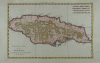 | Details | Bonne, Rigobert | 1780 |
| Carte de l'Isle de la Jamaique |
|
Bonne, Rigobert |
|
| 1780 |
| LOC:5 |
| $150.00 | Bonne--Rigobert | Carte-de-l-Isle-de-la-Jamaique | Attractive hand-colored antique chart by Bonne ca. 1780. Horizontal format of the island of Jamaica showing extensive mountain ranges. Spanish Town, Fort "Ahgusta", and Port Royal Harbor clearly identified. |
| 3601 | 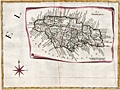 | Details | Zatta, Antonio | 1788 |
| Splendid antique map of Jamaica divided into parishes |
|
Zatta, Antonio |
|
| 1788 |
| LOC:10 |
| $400.00 | Zatta--Antonio | Splendid-antique-map-of-Jamaica-divided-into-parishes | Antique, hand-colored engraving, a decorative map of Jamaica drawn as though on a scroll, published in Antonio Zatta's 'Atlante Novissimo' as sheet IX in his twelve-sheet map of North America. With many engraved place names, rivers, mountains, etc. The island of Jamaica is divided into eighteen parishes including Portland, San Andrea, San Elisabet, and Westmoreland . Numerous place names, all in Italian.
<br></br>
Folio 9. Large compass rose. |
| 371 | 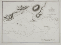 | Details | Direccion Hidrografia | 1809 |
| Plano del Fondeadero Bleufields |
|
Direccion Hidrografia |
|
| 1809 |
| LOC:5 |
| $500.00 | Direccion-Hidrografia | Plano-del-Fondeadero-Bleufields | Chart of southwest coast of Jamaica near Bluefields Bay (Bleufields), near the current town of Belmond. Noted feature include El Fuerte on a point jutting into the Caribbean and a small rocky island "Arrecife del Moro". North is oriented to the left.
<BR> </BR>
Published in 1809, this large-scale port/harbor chart is one of 22 charts of ports in Haiti, Dominican Republic and Jamaica (on 16 plates) published by the Spanish Admiralty, the Direccion Hidrografia, in Part IV of the atlas "Portolano de la America Setentrional Construido en la Direccion Detrabajos Hidrograficos". Because of Spain's secrecy about its New World territories these charts represent some of the earliest detailed charts of these areas. These small charts do not often appear on the market. Plate Number 6. Scale in cables.<BR> </BR>
Reference: Materiales para una Cartografia Mexicana. Manuel Orozco y Berra. 1871. p. 216. |
| 372 |  | Details | Direccion Hidrografia | 1809 |
| Puerto de Mosquito (Jamayca) |
|
Direccion Hidrografia |
|
| 1809 |
| LOC:5 |
| $500.00 | Direccion-Hidrografia | Puerto-de-Mosquito-(Jamayca) | Chart of Mosquito Cove on the north coast of Jamaica (Jamayca) near Barbican and between Lucea Harbor and Sandy Bay . North is oriented to the bottom. Numerous soundings and hazards are marked. Plate Number 4. Scale in cables.<BR> </BR>
Published in 1809, this large-scale port/harbor chart is one of 22 charts of ports in Haiti, Dominican Republic and Jamaica (on 16 plates) published by the Spanish Admiralty, the Direccion Hidrografia, in Part IV of the atlas "Portolano de la America Septentrional Construido en la Direccion Detrabajos Hidrograficos". Because of Spain's secrecy about its New World territories these charts represent some of the earliest detailed charts of these areas. <BR> </BR>
Reference: Materiales para una Cartografia Mexicana. Manuel Orozco y Berra. 1871. p. 216. |
| 373 | 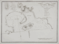 | Details | Direccion Hidrografia | 1809 |
| Puerto Antonio (Jamayca) |
|
Direccion Hidrografia |
|
| 1809 |
| LOC:5 |
| $500.00 | Direccion-Hidrografia | Puerto-Antonio-(Jamayca) | Chart of Puerto Antonio, the capital of the parish of Portland, on the northeast coast of Jamaica (Jamayca) Legend at right identifies 8 features including a church, fortress, and watering spot. North is oriented to the bottom. Numerous soundings, rocks, and hazards are marked. Plate Number 1. Scale in cables.<BR> </BR>
Published in 1809, this large-scale port/harbor chart is one of 22 charts of ports in Haiti, Dominican Republic and Jamaica (on 16 plates) published by the Spanish Admiralty, the Direccion Hidrografia, in Part IV of the atlas "Portolano de la America Septentrional Construido en la Direccion Detrabajos Hidrograficos". Because of Spain's secrecy about its New World territories these charts represent some of the earliest detailed charts of these areas. <BR> </BR> |
| 376 | 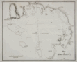 | Details | Direccion Hidrografia | 1809 |
| Plano de Bahia Antigua |
|
Direccion Hidrografia |
|
| 1809 |
| LOC:200 |
| $400.00 | Direccion-Hidrografia | Plano-de-Bahia-Antigua | Chart by the Direccion Hidrografia of the southern coast of Jamaica centered on what is today called Moore's Pen. When the chart was published a small settlement in that area is noted as "Bahia Antigua". Coverage includes Great Goat Island, Ridley's Bay, Coleman's Bay, Salt River Bay, Peake Bay, Mahoe Gardens, and Portland Point although places names on the chart from 1809 do not always correspond to today's. Somewhat larger that the other charts from the Portolano. Plate Number 7. Scale in cables.<BR> </BR>
Published in 1809, this large-scale port/harbor chart is one of 22 charts of ports in Haiti, Dominican Republic and Jamaica (on 16 plates) published by the Spanish Admiralty, the Direccion Hidrografia, in Part IV of the atlas "Portolano de la America Septentrional Construido en la Direccion Detrabajos Hidrograficos". Because of Spain's secrecy about its New World territories these charts represent some of the earliest detailed charts of these areas. <BR> </BR> |
| 1324 | 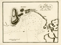 | Details | Direccion Hidrografia | 1809 |
| Antique chart of Montego Bay, Jamaica (Jamayca) |
|
Direccion Hidrografia |
|
| 1809 |
| LOC:5 |
| $600.00 | Direccion-Hidrografia | Antique-chart-of-Montego-Bay--Jamaica-(Jamayca) | Antique Spanish chart of the harbor at Montego Bay, Jamaica (Jamayca) by Spain's Direccion Hidrografia. Jamaica was a colony of Spain from 1511 until 1655, when England drove the Spanish from the island.
<BR> </BR>
Named features on this copper-plate engraved chart include:
<div class="indenttextblock">
<ul style="list-style-type: circle;">
<li>Poblacion de Barnat (Barnett Estate Plantation)</li>
<li>Rio Montego</li>
<li>Monte de Richmond</li>
<li>Punta de Fuerte Viejo (the old British fort)</li>
<li>Punta de Arenas</li>
</ul>
</div>
Published in 1809, this large-scale port/harbor chart is one of 22 charts of ports in Haiti, Dominican Republic and Jamaica (on 16 plates) published by the Spanish Admiralty, the Direccion Hidrografia, in Part IV of the atlas "Portolano de la America Septentrional Construido en la Direccion Detrabajos Hidrograficos". Because of Spain's secrecy about its New World territories these charts represent some of the earliest detailed charts of these areas.
<BR> </BR>
North is oriented to the left. Numerous soundings and hazards are marked. Plate Number 3. Scale in cables. Reference: (Materiales para una Cartografia Mexicana. Manuel Orozco y Berra. 1871. p. 216.) |