| | Thumbnail | | Creator | Date | Title / Author / Date / Location | Price | | | Description |
| 1460 | 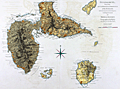 | Details | Jefferys, Thomas | 1775 |
| Antique Chart of Guadeloupe in the Caribbean Sea Jefferys Sayer |
|
Jefferys, Thomas |
|
| 1775 |
| LOC:51 |
| $800.00 | Jefferys--Thomas | Antique-Chart-of-Guadeloupe-in-the-Caribbean-Sea-Jefferys-Sayer | Fine antique British chart of the island of Guadeloupe ("Guadaloupe") in the Caribbean Sea. Includes the nearby islets of Marie-Galante, Isle des Saintes, Petit Terre, and la Desirade. Jefferys names three main sections of Guadeloupe: Basse Terre, Cares Terre, and Grand Terre. With depth soundings, sand banks, and anchorages identified. Fine central compass rose.
<br></br>
Attribution reads: London. Printed for Robert Sayer Map and Printseller. No. 53 Fleet Street as the act directs 20 February, 1775.
<br></br>
The chart is from the scarce <b>first issue of The West-India Atlas, 1775 by Sayer</b>, the other issues being 1781, 1787, 1794, 1796, 1807, and 1818 published by Sayer and then Laurie and Whittle. The volume combined both the elements of an atlas and a pilot, with geographic and hydrographic information. The maps include those for the larger individual islands of the West Indies. <a href="https://www.davidrumsey.com/home" target="_blank">(Online).</a> |
| 1443 | 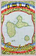 | Details | Raggio, Antonio | 1939 |
| Manuscript map of the Caribbean island of Guadeloupe |
|
Raggio, Antonio |
|
| 1939 |
| LOC:5 |
| $300.00 | Raggio--Antonio | Manuscript-map-of-the-Caribbean-island-of-Guadeloupe | Beautiful manuscript map of Guadeloupe (Isla Guadalupe), part of the Lesser Antilles in the Caribbean Sea. Includes the Isles des Saintes and Maria Galante Island. Fine detail with rivers, mountains, and cities identified. Includes a separate matching fact sheet on the island in Spanish. Both on light card stock.
<br></br>
By Antonio F. Raggio as one in a series of ink and watercolor maps on cards prepared for the Exposicion Filatelica Internacional 11th Congreso de la Union Postal Universal (World Postal Congress), held in Buenos Aires, Argentina in 1939. It is likely that the manuscript cards were proof drawings or models for the engraving of stamps. |