| | Thumbnail | | Creator | Date | Title / Author / Date / Location | Price | | | Description |
| 585 |  | Details | Homann Heirs | 1740 |
| Regni Sinae vel Sinae Propria |
|
Homann Heirs |
|
| 1740 |
| LOC:0 |
| $0.00 | Homann-Heirs | Regni-Sinae-vel-Sinae-Propria | SOLD<br></br>Large hand-colored engraved antique map of China ca. 1740 divided into provinces. Coverage includes Shanghai, the large islands of Hainan and Taiwan, and the Pearl River delta with Hong Kong and Macau.
<br></br>
Decorative title cartouche at bottom right is flanked by a pair of "Chinamen" and Chinese dragons.
<br></br>
Published by the firm Homann Heirs. Homann Heirs (also "Homannianis Heredibus" or "Homann Erben" or "Heritiers de Homann") was a company established after the death of German cartographer J.B. Homann to carry on the publishing business of the firm he started in the early 1700's. The designation "Homann Heirs" appears on maps published by that successor firm from about 1730 to 1848. |
| 579 | 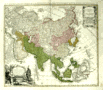 | Details | Homann Heirs | 1744 |
| Carte de l'Asie |
|
Homann Heirs |
|
| 1744 |
| LOC:59 |
| $355.00 | Homann-Heirs | Carte-de-l-Asie | Decorative antique map of Asia dated to 1744. Coverage include Egypt, Saudia Arabia, the Persian Gulf, India, China, Borneo, New Guinea, Siberia, and Japan, and the North Pole. Bottom left of this antique map contains a title cartouche with a large lizard, natives, and subtropical fauna.
<br></br>
Published by the firm Homann Heirs. Homann Heirs (also "Homannianis Heredibus" or "Homann Erben" or "Heritiers de Homann") was a company established after the death of German cartographer J.B. Homann to carry on the map publishing business of the firm he started in the early 1700's. The designation "Homann Heirs" appears on maps published by that successor firm from about 1730 to 1848.
<br></br> |
| 402 |  | Details | Bellin, Jacques Nicolas | 1750 |
| Macao |
|
Bellin, Jacques Nicolas |
|
| 1750 |
| LOC:6 |
| $180.00 | Bellin--Jacques-Nicolas | Macao | Early chart of the port of Macao, China by Bellin ca. 1750. |
| 1475 | 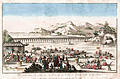 | Details | Huquier Fils. | 1760 |
| Antique vue d'optique of the Port of Beijing Pekin, China |
|
Huquier Fils. |
|
| 1760 |
| LOC:6 |
| $320.00 | Huquier-Fils- | Antique-vue-d-optique-of-the-Port-of-Beijing-Pekin--China | Scarce French vue d'optique or optical print ca. 1760 of the Port of Pekin or Beijing, China. Engraved by the sons of Jacques Gabriel Huquier. In the foreground of this colorful original antique engraving numerous covered boats are unloaded by a variety of workers dressed in colorful native apparel.
<br></br>
Attribution at bottom reads "A Paris ches Huquier Fils, Graveur rue St. Jacques, au Grand St. Remy." Jacques Gabriel Huquier (1725 - 1805) was an engraver and printseller located at Rue St. Jacques in Paris, France. Jacques-Gabriel fils was the son of J. Gabriel Huquier, also a printseller and engraver who worked from the same address. According to Jeffares, Jacques-Gabriel Huquier made a fortuitous marriage in 1758:
<div class="indenttextblock">"[J.G. Huquier] married Anne-Louise, the daughter of the engraver Jacques Chéreau. She brought a dowry of 10,000 livres, mostly in stock in the business at rue Saint-Jacques, “au Grand Saint-Rémy”, and for the next three years with Huquier fils and Chéreau collaborated as engravers and printsellers." (Source : http://www.pastellists.com/Articles/HUQUIER.pdf.)
</div>
By 1772 Huquier had abandoned his family and emigrated to England. Screenplay in progress. |
| 940 | 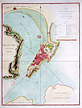 | Details | Barrow, John | 1796 |
| Large antique plan of Macau, China |
|
Barrow, John |
|
| 1796 |
| LOC:59 |
| $1,800.00 | Barrow--John | Large-antique-plan-of-Macau--China | Spectacular plan of <b>Macau or Macao</b>, the Macao Special Administrative Region of the People's Republic of China. Published in George Staunton's "An Authentic Account of an Embassy from the King of Great Britain to the Emperor of China", a work which documented <b>Britain's first official embassy to China</b>, lead by Lord Macartney, in 1792.
<br></br>
Published on April, 12, 1796 by George Nicol. |
| 440 | 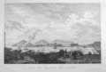 | Details | Duché de Vancy, Gaspard | 1797 |
| Vue de Macao en Chine |
|
Duché de Vancy, Gaspard |
|
| 1797 |
| LOC:0 |
| $0.00 | Duché-de-Vancy--Gaspard | Vue-de-Macao-en-Chine | SOLD
<br></br>
Very attractive copperplate engraved view of the former Portuguese colony of Macau as it existed in 1787. Macau is now a special administrative region of China. <BR> </BR>
Drawn by Gaspard Duchè de Vancy, a French artist of the 18th century. From the "Atlas du Voyage de La Perouse" published by Jean-Francois La Perouse. La Perouse led a scientific expiration to the Pacific from 1785, accompanied by Duchè de Vancy, and sent the drawing on which this engraving is based to France in 1788 with the intention of returning home by 1789. Departing Botany Bay, Australia in March 1788 neither La Perouse, his ships the Boussole or Astrolabe, nor his men were ever seen again. Number 40.<BR> </BR>
Believe the engraving is an early 20th century re-strike from the original copper plate produced by the French Chalcographie du Louvre. La Chalcographie du Louvre is a repository of more that 13,000 original plates from the Louvre's archives, housed upstairs above the Louvre's Paris galleries . Upon request visitors can have a engraving produced on museum-quality paper from the original plate by a master printer. V. 26.<BR> </BR> |
| 4725 | 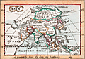 | Details | Turner, Richard (Rev.) | 1799 |
| Antique Miniature Map of Asia |
|
Turner, Richard (Rev.) |
|
| 1799 |
| LOC:0 |
| $95.00 | Turner--Richard-(Rev-) | Antique-Miniature-Map-of-Asia | Antique miniature map of Asia by Turner. Includes India, Tibet, China, Japan, Arabia, Persia, Siberia, New Britain, and the Philippine Islands. Hand colored on paper with watermark.
<br></br>
From one of the smallest geographical atlases issued in the 18th century: <b>A New and Easy Introduction to Universal Geography</b>. First issued in 1794. Reverend Richard Turner's most successful publication went through at least 11 editions. Verso blank.
<br></br>
Within Letter XXIII of Turner's Universal Geography the author introduces the reader to the geography, dress, climate, and culture of the region.
<div class="indenttextblock">
Asia … is superior to Europe and Africa in the extent of its territories, stretching into all climates; from the frozen wilds of Siberia, where the hardy inhabitants, clothed in furs, are drawn in sledges over the snow; to the sultry regions of India and Siam, where, seated upon lofty elephants, the people shelter themselves from the scorching sun by spreading umbrella.
</div>
In two paragraphs Turner lays out the riches available in the region and then describes those peoples in unflattering terms which some could argue formed the basis for exploiting those same resources.
<div class="indenttextblock">
Most of the islands lying |
| 4969 | 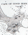 | Details | British Admiralty Hydrographical Office | 1849 |
| Antique Admiralty Chart Eastern China Chelang To Chauan |
|
British Admiralty Hydrographical Office |
|
| 1849 |
| LOC:59 |
| $575.00 | British-Admiralty-Hydrographical-Office | Antique-Admiralty-Chart-Eastern-China-Chelang-To-Chauan | Antique nautical chart of China coast. First edition of a scarce Admiralty nautical chart of the East coast of China. <b>"Sheet III - Eastern Coast from Chelang Pt. To Chauan Bay"</b> .
<br></br>
Includes an area north of Hong Kong from Jieshi Bay ( "Hie-Che-Chin Bay" ) trending northeast past Nan'ao ( "Namoa" ) Island to Zhao'an Bay ( "Chauan Bay" ). In 2007, off the coast of Nan'ao island local fishermen discovered a shipwreck, Nan'ao One, considered to be the first late Ming dynasty ship ever found; likely the only one from the reign of Emperor Wanli (1573–1620) that China has discovered.
<br></br>
Manuscript pencil and ink course plot lines and position plots. Published September 12, 1849 by the Hydrographic Agency of the British Admiralty. Number 1963. Four detailed inset port/harbor plans:
<div class="indenttextblocksingle">
<ul style="list-style-type: circle;">
<li>Chino Bay</li>
<li>Cupchi Point</li>
<li>Cape of Good Hope</li>
<li>Hai Mun</li>
</ul>
</div>
Based on a survey conducted by Royal Navy Captain R. Collinson in 1845. Published by the Admiralty September 12, 1849. Engraved by J & C Walker. Chart #1963. |
| 841 | 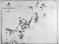 | Details | British Admiralty Hydrographical Office | 1849 |
| Nautical chart of China Between Taizhou and Wenzhou |
|
British Admiralty Hydrographical Office |
|
| 1849 |
| LOC:0 |
| $475.00 | British-Admiralty-Hydrographical-Office | Nautical-chart-of-China-Between-Taizhou-and-Wenzhou | British sea chart of the East coast of China, in Zhejiang province, from Taizhou ( "Taichow" ) to Wenzhou ( "Wan-Chew Foo" ), China. Coverage on this old nautical chart includes the Dachen Islands, consisting of 29 islands, rocks, and islets to the east of Taizhou. Also shown East of Wenzhou in the East China Sea is Dongtou, an island district in China composed of 168 islands.
<br></br>
Published from London by the British Admiralty, originally in 1843. This edition was produced in August 1849. Sold by J.D. Potter 31 Poultry and 11 King Street, Tower Hill. |
| 577 |  | Details | British Admiralty Hydrographical Office | 1882 |
| China Eastern Coast Hieshan Isles to the Yang-Tse-Kiang |
|
British Admiralty Hydrographical Office |
|
| 1882 |
| LOC:0 |
| $1,100.00 | British-Admiralty-Hydrographical-Office | China-Eastern-Coast-Hieshan-Isles-to-the-Yang-Tse-Kiang | Rolled British Admiralty sea chart of China's Eastern coast first published October 3, 1849. Coverage includes Shanghai, China, the mouth of the Yangtze River and part of the Poo-Tung (Putuo) Peninsula south to the Chusan (Zhoushan) islands. This edition of the antique nautical chart reflects the latest corrections made in 1882. With an attached extension at left. The chart is comprised of one large lithographed sheet conjoined with two smaller sheets when published.
<br></br>
Sold by J.D. Potter agent for the Admiralty Charts. 31 Poultry and 11 King Street Tower Hill (London). Number 1199. Price when issued was three shillings. |
| 4760 | 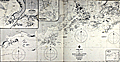 | Details | British Admiralty Hydrographical Office | 1907 |
| China From Hailing Island to Hong Kong with Macao |
|
British Admiralty Hydrographical Office |
|
| 1907 |
| LOC:59 |
| $0.00 | British-Admiralty-Hydrographical-Office | China-From-Hailing-Island-to-Hong-Kong-with-Macao | SOLD<br></br>
Fine, very scarce original British Admiralty nautical chart of the coast of China west of <b>Hong Kong</b> by Belcher. Published in 1853 (1907), this fine sea chart was engraved by J & C Walker.
<br></br>
Coverage extends from Hailing Island (Hui Ling Island) past Macau and ends with Hong Kong. Includes three detailed inset charts and plans: Macao Harbour, Namo Harbour, and Hui-Ling (Hailing) Harbour.
<br></br>
First published Sept 4, 1853 according to an Act of Parliament at the Hydrographic Office of the Admiralty. Corrections to 1883 by Captain J. Calder of the Chinese Gunboat Sui-Tsing. Numerous minor corrections, with the last small correction in 1907. This chart 2212 is a later edition of Belcher's Admiralty chart 1625 "Mongchow to Hong Kong".
<br></br>
Verso with several MS chart collation numbers including a stenciled "143". Sold by J.D. Potter Agent for Admiralty Charts, 146 Minories. Chart number 2212. Two sheets joined; one vertical fold.
<br></br>
Admiral Sir Edward Belcher (1799 – 1877) was born in Nova Scotia and at age 13 enlisted as a volunteer in the British Royal Navy. Belcher went on to a long career as a British naval officer, hydrographer, and explorer. Belcher is credited with producing the first detailed map of Hong Kong in 1841, one year before the island was handed over to Britain. |
| 4737 | 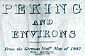 | Details | British War Office | 1909 |
| Rare Map of Peking and Environs |
|
British War Office |
|
| 1909 |
| LOC:62 |
| $6,000.00 | British-War-Office | Rare-Map-of-Peking-and-Environs | Extremely rare British map of Beijing or Peking, China drawn prepared by the British Ordnance Survey Office, Southampton for the War Office. Dated within to 1909. Blue ink stamp to recto "For Official Use Only". Black oval stamp on verso: "North China Command, 7 Jul 1910, General Staff."
<br></br>
Not found in the Antique Map Price Record (AMPR).
<br></br>
Cartographically the map is based upon a 1907 German map published in Berlin entitled Peking und Umgebung. This map was created during the period of occupation following the suppression of the 1900 Boxer Rebellion, an era that produced detailed survey work, such as the present map, in anticipation of urban management needs and infrastructure development.
<br></br>
In the present example, stamped Chinese characters have been added for each English location name.
Chart no. 2417. |
| 6835 | 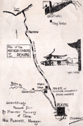 | Details | Yenching University Geology Department | 1927 |
| Rare Advertising Brochure Map of Peking for Sanitary Fur Company |
|
Yenching University Geology Department |
|
| 1927 |
| LOC:41 |
| $320.00 | Yenching-University-Geology-Department | Rare-Advertising-Brochure-Map-of-Peking-for-Sanitary-Fur-Company | Rare, unrecorded pictorial advertising map of Peking or Beijing, China prepared ca. 1927 for the Sanitary Fur Company by the Department of Geology and Geography at Yenching University. The maps are signed by George Barbour (1). Format: small tourist-oriented folding brochure.
<br><br>
The interior of the brochure shows a two-panel "Simplified Map of Peking". Back panel with a smaller-scale "Plan of the Northern Environs of Peking."
<br><br>
According to an inserted sheet found within:
<div class="indenttextblocksingle">
"The tanning of furs in China was started by Dr. H. S. Vincent, head of the Leather Department of Yenching University. This much needed step has popularized Chinese furs as the tanning makes them perfectly sanitary, all germs being killed in the process which also destroys the disagreeable smell so noticeable with Chinese furs imperfectly tanned."
</div><br>
<div id="SC_6835" align="center">
<a title=""></a>
<img id="6835" src="/ZoomifyImages/SC_6835/SC_6835_detail.jpg" alt="Advertisement for the Sanitary Fur Company. Peking China. 1927." width="300"/> <br><font size="-2">Advertisement for the Sanitary Fur Company. 1927.</font>
</div><br> |
| 5290 | 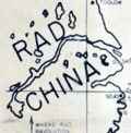 | Details | Anonymous | 1949 |
| Unrecorded comical map related to the Communist Revolution in China |
|
Anonymous |
|
| 1949 |
| LOC:9 |
| $0.00 | Anonymous | Unrecorded-comical-map-related-to-the-Communist-Revolution-in-China | SOLD
<br></br>
Unrecorded, and somewhat puzzling comical map of East Asia (China, Korea, Japan) inspired by Al Capp's "Lower Slobbovia" cartoon map from Capp's Li'l Abner comic book series (1949). In crude Russian and Chinese-inflected dialect the map documents (in manuscript red ink) the exodus of American workers from Shanghai, China to the United States during the last two years of the Chinese Civil War. This is a U.S. artifact from the early establishment of the People's Republic of China after WWII with a probable connection to the U.S. military [1]. Very rare. Not found anywhere else on this planet.
<br></br>
After the end of WWII United States companies built lucrative businesses within China. During 1948 and 1949, it became clear that the Chinese Nationalist forces under Chiang Kai-shek (supported by the U.S.A.) would be defeated by Chinese Communist forces, led by Mao Zedong and supported by Russia. U.S. diplomats and civilian business leaders began an exodus [2] from China. By May, 1949 the stream of foreigners leaving China was concentrated in Shanghai, China where most caught ships to the U.S.A [3], [4].
<br></br>
Includes a depiction of the Trans Manchuria Railway with an unknown connection to salt. The railway is shown extending from Saltport (Dalian), past Saltograd, Staffograd, past the Rad (Red) River and ending near Slobbovian Salt Mines.
<br><br>
Note:<br>
Humerican = American<br>
Pitchavich=Peretychika, Russia<br>
Havaveto = Pyongyang, North Korea<br>
<br>
[1]"You is here you lucky dogs" = Zama, Japan, the earliest U.S. Army barracks in Japan and the former site of the Imperial Japanese Army Academy.
[2] "Where Rad (Red) revolution is ending Humerican blue platt specials."
[3] "Is showing route of 'Vanishink Humerican' class of 1948 and 1949."
[4] Shows a sea route in MS red ink connecting Gimpo (Kimpo), Korea; Shanghai, China; and the United States. |
| 5028 | 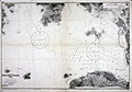 | Details | British Admiralty Hydrographical Office | 1963 |
| Chart of Hong Kong Waters West China South Coast |
|
British Admiralty Hydrographical Office |
|
| 1963 |
| LOC:59 |
| $1,000.00 | British-Admiralty-Hydrographical-Office | Chart-of-Hong-Kong-Waters-West-China-South-Coast | Twentieth-century British Admiralty nautical chart of western Hong Kong Harbor, Hong Kong Island, Victoria Harbor, and Belcher Harbor. Extends as far west as Lantau Island in the vicinity of Hong Kong Disneyland.
<br></br>
Engraved and first published by the Admiralty in 1903, this edition contains minor corrections to 1963. Chart number 3280. Numerous updates to aids to navigation shown in red ink. |
| 6449 |  | Details | Great Wall Poster Company | 1982 |
| 1982 Pictorial Advertising Map of Hong Kong |
|
Great Wall Poster Company |
|
| 1982 |
| LOC:1404 |
| $0.00 | Great-Wall-Poster-Company | 1982-Pictorial-Advertising-Map-of-Hong-Kong | SOLD<br><br>
Scarce 1982 thematic pictorial advertising map for Hong Kong published by Great Wall Poster Company. Shows geographical locations around the city with numerous small pictorial advertisements for local businesses. A snapshot of the frenetic commercial activity surrounding Hong Kong in the last decade of the 20th century. Businesses of all sizes and sectors are represented on the map including transportation, hospitality, banking, and entertainment. For example:
<div class="indenttextblocksingle">
<ul style="list-style-type: circle;"></li>
<li>Colosseum Disco</li>
<li>Japan Air Line</li>
<li>Royal Hong Kong Jockey Club</li>
<li>Far East Hydrofoil Co. Ltd.</li>
<li>Beefy's Bistro</li>
<li>Credit Suisse</li>
<li>Kowloon's number one nightspot 'Bottoms Up' (the basement)</li>
</ul>
</div>
<div id="0" align="center">
<a title="Compass rose Hong Kong pictorial map, 1982."></a>
<img id="3" src="/ZoomifyImages/SC_6449/SC_6449_CompassRose.jpg" alt="Compass rose 1982 Annual Poster of Hong Kong by Tom Briggs." width="300"/> <br><small>1982 Hong Kong map compass rose "for Australian readers." </small>
</div><br>
The creator uses humor to enliven the company descriptions and shows that at an early date there was concern about the reversion of Hong Kong to Chinese rule: "Buy your poster now, it may be smaller after 1997." Compass rose rotated 180 degrees with north oriented to bottom. Map has an antique appearance by design.
<br><br>
In this pictorial map pictograms are used along with text to identify specific commercial enterprises conducting business in Hong Kong. Based on a statement from a self-portrait of the copyright holder and author, Tom Briggs, the size of the advertisement was correlated to the amount that advertisers were willing to pay for a spot on the map "Well, how much do you want on the poster for sixteen bucks?" |
| 6484 | 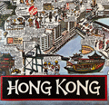 | Details | Great Wall Poster Company | 1990 |
| 1990 Pictorial Advertising Map of Hong Kong |
|
Great Wall Poster Company |
|
| 1990 |
| LOC:1404 |
| $0.00 | Great-Wall-Poster-Company | 1990-Pictorial-Advertising-Map-of-Hong-Kong | SOLD<br><br>
Thematic pictorial advertising map of Hong Kong from 1990. One of a series of annual advertising posters of Hong Kong published by Great Wall Poster Company. Printed by Pronto Print, LTD. Copyright 1980 by Tom Briggs.
<br><br>
Shows geographical locations around the city with interesting historical notes "In 1942 a tiger was shot by a Japanese patrol near Stanley" or "In 1887 the Hong Kong College of Medicine was established and one of its first students was Sun Yat Sen." Contains numerous small pictorial advertisements for local businesses with an attempt at levity in some cases.
<br><br>
The pictorial map is a snapshot of the frenetic commercial activity surrounding Hong Kong in the last decade of the 20th century. Businesses of all sizes and sectors are represented on the map including retail, transportation, hospitality, banking, and entertainment. The numerous commercial enterprises include:
<div class="indenttextblocksingle">
<ul style="list-style-type: circle;"></li>
<li>Hong Kong & Shanghai Banking Corporation</li>
<li>Water tours of Hong Kong, Ltd.</li>
<li>Overseas Containers Limited</li>
<li>George Wimpey H.K. Ltd.</li>
<li>British Caledonian Airline</li>
<li>Singapore Club Coffee House</li>
</ul>
</div>
<div id="0" align="center">
<a title="Detail from Hong Kong pictorial map, 1990."></a>
<img id="3" src="/ZoomifyImages/SC_6484/SC_6484_Detail.jpg" alt="Detail from 1990 Annual Poster of Hong Kong by Tom Briggs." width="330"/> <br><small>1990 Hong Kong pictorial advertising map detail. </small>
</div> |