| | Thumbnail | | Creator | Date | Title / Author / Date / Location | Price | | | Description |
| 761 | 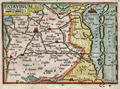 | Details | Langenes, Barent | 1600 |
| Antique map of the Gulf of Venice and Veneto, Italy |
|
Langenes, Barent |
|
| 1600 |
| LOC:0 |
| $0.00 | Langenes--Barent | Antique-map-of-the-Gulf-of-Venice-and-Veneto--Italy | SOLD
<br></br>
Attractive antique map of a portion of the Veneto region of Italy including most of the Gulf of Venice and Venetian lagoon from south of Chioggia ( Cioza ) extending northward past Venice ( Venetia ). The title of the map 'Patavinum', ca. 1600 reflects the fact that it is more or less centered on Padua, called Patavium by the Romans. Named features include towns and islands of Padua, Murano, Torcello, Porto de Sant Erasmo , Porto de Malamocco, Porto de San Nicolò al Lido, Cavarzere, Piove di Sacco, and Monselice.
<br></br>
Map carries the signature of Dutch engraver and globe maker Peter Kaerius (1571-1646) at lower right corner. French text on verso. Probably from one of three editions of the French version of the 'Thresor de Chartes Contenant les Tableaux de Tous le Pays du Monde' published in the early 17th century (1600, 1602, and 1609)
(Source: http://www.septentrionalium.com/Book2_entry1.pdf). |
| 1074 | 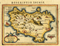 | Details | Bertius, Petrus | 1616 |
| Antique map of the island of Ischia in the Bay of Naples |
|
Bertius, Petrus |
|
| 1616 |
| LOC:4 |
| $150.00 | Bertius--Petrus | Antique-map-of-the-island-of-Ischia-in-the-Bay-of-Naples | Small detailed, 400 year-old map of the volcanic island of Ischia which lies off the coast of Naples, Italy. Ischia is the largest of three islands that lie in or near the Gulf of Naples: Ischia, Capri, and Procida. At the east end of the island is shown the Aragonese Castle built in the year 474.
<br></br>
From the Latin edition of Bertius' 'Tabularum geographicarum contractarum..' |
| 489 | 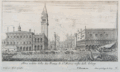 | Details | Sylvester, Israel | 1642 |
| Altra veduta della due piazza di San Marco visto dell'Orloge |
|
Sylvester, Israel |
|
| 1642 |
| LOC:0 |
| $0.00 | Sylvester--Israel | Altra-veduta-della-due-piazza-di-San-Marco-visto-dell-Orloge | SOLD<br></br>
Rare antique etching of St Mark's Square in Venice, Italy, looking much as it does today. The lagoon in the foreground, at left the Biblioteca Marciana with the campanile behind, and at right the Doge's palace; with some gondolas moored to the quay. Far right shows the stern of a large sailing vessel covered with a cloth awning.
<BR> </BR>
Engraved and drawn by artist Israel Sylvestre (1621-1691). Published by Pierre Mariette (1634-1716) 'avec privilege du Roy' in Paris. The print was likely published after 1663 when Sylvestre was appointed court painter and engraver by Louis XIV and would have been able to claim royal privilege. Number 10. |
| 490 | 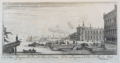 | Details | Sylvester, Israel | 1663 |
| Veduta e prospectiva della Piazza di St. Marco di Venezia |
|
Sylvester, Israel |
|
| 1663 |
| LOC:7 |
| $325.00 | Sylvester--Israel | Veduta-e-prospectiva-della-Piazza-di-St--Marco-di-Venezia | Rare antique copperplate etching of St Mark's Square in Venice, Italy, an oblique view from the Northeast looking down the Grand Canal with the lagoon to the left. At right are the Doge's palace and Biblioteca Marciana with Punta della Dogana and the entrance to the Grand Canal in the background. Shows numerous small vessels underway and moored; at far left the decoratively carved stern of a sailing vessel with banners fluttering in the breeze.
<BR> </BR>
Engraved and drawn by artist Israel Sylvestre (1621-1691). Published by Pierre Mariette (1634-1716) "avec privilege du Roy" in Paris. The print was likely published after 1663 when Sylvestre was appointed court painter and engraver by Louis XIV and would have been able to claim royal privilege. Title also in French at bottom of engraving. Number 11. |
| 357 |  | Details | Blaeu, Johannes | 1663 |
| Milazzo ou Melazzo ville en Sicile |
|
Blaeu, Johannes |
|
| 1663 |
| LOC:8 |
| $350.00 | Blaeu--Johannes | Milazzo-ou-Melazzo-ville-en-Sicile | Sizable map of the fortress at Milazzo, Italy published by Blaeu in 1663. Source was “Theatrum Civitatum et admirandorum Italiae” published from Amsterdam. This scarce antique map depicts the fortress walls in great detail but with no interior detail. The single decorative element is the depiction of a galley in the left bottom corner from which a sailor can be seen fishing. Plate 33. |
| 4777 | 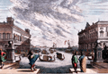 | Details | Baur, Johann Wilhelm and Küsell, Melchior | 1680 |
| Extremely fine antique engraving of the Grand Canal at Venice, Italy |
|
Baur, Johann Wilhelm and Küsell, Melchior |
|
| 1680 |
| LOC:88 |
| $450.00 | Baur--Johann-Wilhelm-and-Küsell--Melchior | Extremely-fine-antique-engraving-of-the-Grand-Canal-at-Venice--Italy | The Grand Canal at Venice, Italy. A finely-engraved and very decorative antique view of Venice's Grand Canal. Against a dramatic, cloudy sky numerous gondolas and, far in the background, lateen-rigged vessels. From the late 17th century.
<br></br>
With a very fine manuscript calligraphic title : "Canal Grando zu Venedig allivo die Gondoli Al Fresco fahren"
<br></br>
Drawn by J. Baur and engraved by Melchior Kussell. Plate 132. With privilege.
<br></br>
Johann Wilhelm Baur (1607-1640) was a German painter, engraver, and etcher. |
| 4942 | 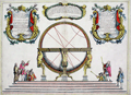 | Details | Coronelli, Vincenzo | 1689 |
| Globe Celeste |
|
Coronelli, Vincenzo |
|
| 1689 |
| LOC:62 |
| $650.00 | Coronelli--Vincenzo | Globe-Celeste | A copper-plate engraved view of the Globe Celeste of Vincenzo Maria Coronelli (1650-1718), considered as one of Italy's most famous and greatest cartographers. Coronelli was an Italian Franciscan friar, cartographer, cosmographer and encyclopedist, a trained wood engraver who studied astronomy, Euclidean geometry and ancient philosophy and was named cosmographer for the Republic of Venice.
<br></br>
Coronelli became most famous for his very large globes built in Paris from 1681-1683 at the order of King Louis XIV. His terrestrial and celestial globes measured 3.9 meters in diameter and were not equaled for more than 200 years.
<br></br>
The print, dated within at 1689, celebrates the consecration of the Celestial Globe in 1683 by Cardinal Destrees. Scarce. Only two sales recorded in the AMPR. |
| 5240 |  | Details | Coronelli, Vincenzo | 1689 |
| Primi Elementi o Introdutione al Corso Geografico |
|
Coronelli, Vincenzo |
|
| 1689 |
| LOC:62 |
| $650.00 | Coronelli--Vincenzo | Primi-Elementi-o-Introdutione-al-Corso-Geografico | An attractive, fine original copper-plate engraving that illustrates the basic principles of geography. The main map is a double hemisphere without landmasses, showing lines of latitude and longitude and climate zones The left sphere is inscribed with the names of the compass points and directions. The right sphere is inscribed with the names of the winds, and the is sphere divided into climatic zones.
<br></br>
The spheres are surrounded by several smaller spherical diagrams and tables making in all a very interesting and informative graphic compilation of the state of geographical knowledge in Venice, Italy at the end of the 17th century. From Coronelli's Atlante Veneto, based on work derived from his large globes.
<br></br>
Vincenzo Maria Coronelli (1650-1718) is considered as one of Italy's most famous and greatest cartographers. Coronelli was an Italian Franciscan friar, cartographer, cosmographer and encyclopedist, a trained wood engraver who studied astronomy, Euclidean geometry and ancient philosophy and was named cosmographer for the Republic of Venice.
<br></br>
Coronelli became most famous for his very large globes built in Paris from 1681-1683 at the order of King Louis XIV. His terrestrial and celestial globes measured 3.9 meters in diameter and were not equaled for more than 200 years. |
| 720 | 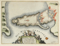 | Details | de Fer, Nicolas | 1693 |
| Syracuse or Siracuse, Sicily |
|
de Fer, Nicolas |
|
| 1693 |
| LOC:4 |
| $0.00 | de-Fer--Nicolas | Syracuse-or-Siracuse--Sicily | SOLD<br><br>
Beautiful antique plan of the fortifications at Syracuse ( Siracuse ) on the Mediterranean island of Sicily. Title cartouche at bottom surrounded by putti engaged in agricultural and food gathering activities. Text in French describes the location precisely with Latitude and Longitude. By Nicolas de Fer, in "Introduction à la fortification." Paris 1693. |
| 393 | 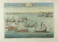 | Details | Fontana, Fulvio | 1701 |
| Presa di Due Galee Turchesche |
|
Fontana, Fulvio |
|
| 1701 |
| LOC:50 |
| $375.00 | Fontana--Fulvio | Presa-di-Due-Galee-Turchesche | Scarce copperplate engraving depicts a battle between Ottoman galleys and galleys from the military order of Saint Stephen (Santo Stefano) Pope and Martyr. Location of that engagement was near the Strait of Bonifacio (Bocche de Bonifazio), between Corsica and Sardegna. The order of Santo Stefano was founded by Cosimo I de' Medici in 1561. The purpose of the order , with financial support from the Grand Dukes of Tuscany, was to free Christians from slavery by fighting Ottomans and pirates. Vessels of the order of Santo Stefano are marked by flags with the symbol of their order, an eight-pointed cross much like that of the Knights of Malta.<BR> </BR>
From: "I pregi della Toscana nell' imprese piu segnalate de' Cavaliere di Santo Stefano opera dat a in luce da Fulvio Fontana della Compagnia di Gesu dedicata all' Altezza Reale di Cosimo III, Gran Duca di Toscana e Gran Maestro dell' Ordine. Published in 1701 from Florence by Mattia Miccioni and Michele Neftenus. Plate 2. Probably from a later state.<BR> </BR>
Reference: http://digital.ub.uni-duesseldorf.de/ihd/content/pageview/3361129 |
| 394 | 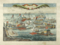 | Details | Fontana, Fulvio | 1701 |
| Presa di Cinque Legni Turcheschi |
|
Fontana, Fulvio |
|
| 1701 |
| LOC:50 |
| $375.00 | Fontana--Fulvio | Presa-di-Cinque-Legni-Turcheschi | Scarce copperplate engraving depicts a battle in 1596 conducted by galleys from the military order of Saint Stephen (Santo Stefano) Pope and Martyr and Muslim corsairs. The battle was led by Francesco Borbolani, eighth Admiral of the order of Santo Stefano. <BR> </BR>
The order of Santo Stefano was founded by Cosimo I de' Medici in 1561. The purpose of the order , with financial support from the Grand Dukes of Tuscany, was to free Christians from slavery by fighting Ottomans and pirates. Vessels of the order of Santo Stefano are marked by flags with the symbol of their order, an eight-pointed cross much like that of the Knights of Malta.<BR> </BR>
From "I pregi della Toscana nell' imprese piu segnalate de' Cavaliere di Santo Stefano opera dat a in luce da Fulvio Fontana della Compagnia di Gesu dedicata all' Altezza reale di Cosimo III, Gran Duca di Toscana e Gran Maestro dell' Ordine. Published in 1701 from Florence by Mattia Miccioni and Michele Neftenus. Plate 10. Probably from a later state of the engraving.<BR> </BR>
Reference: http://digital.ub.uni-duesseldorf.de/ihd/content/pageview/3361129 |
| 879 | 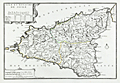 | Details | de Fer, Nicolas | 1701 |
| Antique Map of the Mediterranean island of Sicily, Italy |
|
de Fer, Nicolas |
|
| 1701 |
| LOC:4 |
| $240.00 | de-Fer--Nicolas | Antique-Map-of-the-Mediterranean-island-of-Sicily--Italy | Attractive antique map of the island of <b>Sicily</b> in Italy published from Paris in 1701 . Adjoining the mainland at the "toe" of the Italian peninsula, and separated by the Strait of Messina, the southernmost tip of Calabria is shown with the key city of Reggio.
<br></br>
Much detail in the interior of this original old map includes mountains, rivers, major roads, and villages. Key cities in Sicily include Palermo, Messina, Noto, Mazara, and Siracusa. A few miles northwest of the coastal city of Catania, <b>Mount Etna</b> ( Aetna ) is shown erupting violently.
<br></br>
At the time this map was published Sicily, the largest of all Mediterranean islands, was ruled by Philip IV , King of Spain.
<br></br>
This antique map was produced by the well known French geographer and cartographer, Nicolas de Fer (1646 - 1720) and was published in de Fer's atlas: "L'atlas curieux, ou Le monde réprésenté dans des cartes générales et particulières du ciel et de la terre… et orné par des plans et descriptions des villes capitales et principales ..."
<br></br>
Publication details are found In the lower left corner : <div class="indenttextblock">" A Paris. Chez l'Autheur dans l'Isle du Palais a la Sphere Royale. Avec Privilege du Roy. 1701. " </div> |
| 868 | 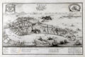 | Details | de Fer, Nicolas | 1705 |
| Antique Engraved Birds-eye View of Venice, Italy |
|
de Fer, Nicolas |
|
| 1705 |
| LOC:7 |
| $500.00 | de-Fer--Nicolas | Antique-Engraved-Birds-eye-View-of-Venice--Italy | Antique birds-eye view of Venice, Italy with the Grand Canal, Giudecca, the Venetian Arsenal, and St. Mark's Square as they existed around 1700. This attractive, detailed, copper-plate engraved view includes the outlying islands of Murano, Mazzorbo, Torcello, San Michelle, and others. Numerous churches are identified by name and a legend at bottom is keyed to the six chief Venetian neighborhoods or sestieri. Ten important locations are identified including the columns at St. Mark's square, erected in the 13th century; two prisons; the Ducal Palace; and the customs house.
<br></br>
This antique view was produced by the well known French geographer and cartographer, Nicolas de Fer (1646 - 1720). De Fer was a prolific producer of maps and prints who among other honors, was appointed as official geographer to the Spanish King in 1702. Published in de Fer's atlas: "L'Atlas Curieux, ou Le monde réprésenté dans des cartes générales et particulières du ciel et de la terre… et orné par des plans et descriptions des villes capitales et principales, ...". |
| 572 | 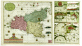 | Details | van Keulen, Gerard | 1724 |
| Sicilia |
|
van Keulen, Gerard |
|
| 1724 |
| LOC:0 |
| $4,000.00 | van-Keulen--Gerard | Sicilia | Extra-large, rare, original antique nautical chart of the island of Sicily, Italy. <strong>Two views of an erupting Mount Aetna ( Etna ) in Catania.</strong> Includes nine smaller harbor charts on the same sheet: Palermo, Trapani, Messina, Milazzo, Augusta, Catania, Agrigento and Siracusa. Unusually colorful and attractive specimen. Unusual to find this combination of large-scale and small-scale charts on a single page.
<br></br>
Inset at right in the sea shows two scenes related to the Battle of Cape Passaro, between Spanish and British naval forces on August 11, 1718 off the coast of Sicily. During the Battle of Cape Passaro, off the southeast coast of Sicily, forces led by British Admiral Sir George Byng aboard the flagship 'Barfleur' defeated Spanish naval forces led by Rear-Admiral Don Fernando Chacon.
<br></br>
By Gerard van Keulen, with the royal privilege, possibly from the third part of 'De Nieuwe Groote Lichtende Zee-Fakkel' published 1724. Near van Keulen's name is found the Coat of Arms of the Kingdom of Sicily with two facing eagles flanking the red stripes of the arms of the House of Aragon. |
| 252 | 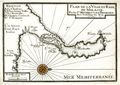 | Details | Michelot and Bremond | 1730 |
| Plan de la Ville et Rade de Melasse (Milazzo, Sicily) |
|
Michelot and Bremond |
|
| 1730 |
| LOC:4 |
| $300.00 | Michelot-and-Bremond | Plan-de-la-Ville-et-Rade-de-Melasse-(Milazzo--Sicily) | Antique copperplate chart of Cape Milazzo, Sicily from French galley pilot and hydrographer <a style="color:#9BAFCB" rel="nofollow" href= "/MichelotBremondBackground.aspx">Henri Michelot.</a> This is one of four old charts of Sicilian ports in Michelot's and Bremond's important 37-plate atlas of 1730: <a id="A3" href="http://www.rarecharts.com/ShowDetail/Creator/Michelot-and-Bremond/Title/Recueil-de-plusieurs-plans-des-ports-et-rades-de-la-mer-mediterranee---(Atlas-of-37-plates)/230" onclick="_gaq.push(['_trackEvent', 'Michelot and Bremond, 'View All', 'MichelotBremondBackground']);">
“Recueil de Plusiers Plans des Ports et Rades de la Mer Mediterranee". </a>
<BR> </BR>
The town of Milazzo (Melasse) , Sicily is clearly shown surrounded by Vauban-style defensive walls and the nearby sea area is marked with sparse soundings and a few anchorages. The charts contains a feature that is unusual for these smaller plans-- labeled, keyed references to five locations in Milazzo: Le Chateau; l'Ancienne Ville; La Nouvelle; Chemin Couvert; and St. Francois. These detailed labels suggest a high level of familiarity with the area. |
| 570 |  | Details | Homann Heirs | 1742 |
| Italia |
|
Homann Heirs |
|
| 1742 |
| LOC:58 |
| $490.00 | Homann-Heirs | Italia | Attractive antique map of Italy divided into provinces with the islands of Corsica ( Corse ), Sardinia ( Sardegna or Sardigna ), Sicily ( Sicilia ), Malta, Gozo, and Lampedusa. This large 18th century, hand-colored engraving was published from Nuremberg, Germany in 1742 (dated at top of map). Decorative title cartouche in Latin at bottom left of the map.
<br></br>
By the heirs of J. B. Homann. Homann Heirs (also "Homannianis Heredibus" or "Homann Erben" or "Heritiers de Homann") was a company established after the death of the famous German cartographer Johann Baptist Homann to carry on the publishing business of the firm he started in the early 1700's. The designation "Homann Heirs" appears on maps published by that successor firm from about 1730 to 1848. |
| 583 |  | Details | Homann, Johann | 1745 |
| Totius Regni Neapolis |
|
Homann, Johann |
|
| 1745 |
| LOC:58 |
| $600.00 | Homann--Johann | Totius-Regni-Neapolis | Map of the southern boot of Italy divided into provinces. Coverage of this antique hand-colored map includes islands of both the Tyrhennian Sea and Adriatic Sea including Capri, Procida, Ischia, Naples ( Napoli ), Stromboli, Lipari, Basilio, the Tremiti Islands and the northern tip of Sicily including Milazzo and the Strait of Messina. Two decorative cartouches give life to the map, one includes a sea serpent, flying horses and numerous putti fencing with epee.
<br></br>
Drawn by famous German cartographer Johann Homann ca. 1720, the map was published later by the firm Homann Heirs. Homann Heirs (also "Homannianis Heredibus" or "Homann Erben" or "Heritiers de Homann") was a company established after the death of Homann to carry on the publishing business of the firm he started in the early 1700's. The designation "Homann Heirs" appears on maps published by that successor firm from about 1730 to 1848. |
| 1181 |  | Details | Ayrouard, Jacques | 1746 |
| Antique plan of the Bay of Taranto, Italy |
|
Ayrouard, Jacques |
|
| 1746 |
| LOC:8 |
| $375.00 | Ayrouard--Jacques | Antique-plan-of-the-Bay-of-Taranto--Italy | Distinctive antique engraved French port plan / chart ca. 1746 for the bay and walled village of Taranto, Italy a coastal city in Apulia. Today, Taranto is the capital of the Province of Taranto and is an important commercial port as well as the main Italian naval base and claims a population of over 200,000 persons.
<br></br>
The antique chart is by Jacques Ayrouard (Marseilles ca. 1732- 1746) from a scarce atlas titled: "Recueil de Plusiers Plans des Ports et Rades et de Quelque Cartes Particulieres de la Mer Mediterranee". Plate 37.
<br></br>
Ayrouard identifies a few key landmarks including several offshore: La Pizolle, Isle Pisco, Isle de St. George, and two channels into the bay. On land only a few landmarks are noted including guard towers, the port; the village of Taranto ("Tarante") connected to the mainland by two bridges; and the Pointe de Victo where today is found the area of San Vito.
<br></br>
In the attribution Ayrouard is described as "Pilot Real" or pilot of la Reale, the flagship of the French galley corps with a total complement of about 550 including 360 oarsmen and 100 soldiers. In their <i>Dictionnaire de la Marine</i> from 1702 Covens and Mortier explain: <div class="indenttextblock">"(Réale) is the name of the main galley of an independent kingdom, not of a tributary kingdom annexed to a greater one. The Réale, in France, is reserved for the general of the galleys and flies the royal ensign which distinguishes it from the others. This ensign is square in shape and red in colour, with golden fleurs-de-lys." <a href="http://www.ulmo.net/bateaux/reale/dico02.jpg" target="_blank"> (Internet)</a> </div>
Ayrouard was likely one of the last galley pilots as the French galley corps was disbanded in 1748 and incorporated into the regular French sailing navy. |
| 907 |  | Details | Ayrouard, Jacques | 1746 |
| Antique plan of the port of Livorno, Italy |
|
Ayrouard, Jacques |
|
| 1746 |
| LOC:8 |
| $525.00 | Ayrouard--Jacques | Antique-plan-of-the-port-of-Livorno--Italy | Antique French port plan / chart for the town of Livorno, Italy located on the western coast of the Tuscany region.
The antique chart is by Jacques Ayrouard (Marseilles ca. 1732- 1746) from a scarce atlas titled: "Recueil de Plusiers Plans des Ports et Rades et de Quelque Cartes Particulieres de la Mer Mediterranee".
<br></br>
Ayrouard identifies a few key landmarks including several offshore: a "fanal" or lighthouse and another the "Tour de la Marsoque". On land only a few landmarks are noted including "Les 4 gigantes" a reference to the Four Moors statue (the engraver includes a tiny icon-like representation of the statue) next to "la darce" or the old port for Livorno; a church- St. Francois; and of course the walled town of Livorno ("Livourne") itself.
<br></br>
In the attribution Ayrouard is described as "Pilot Real" or pilot of la Reale, the flagship of the French galley corps with a total complement of about 550 including 360 oarsmen and 100 soldiers. In their <i>Dictionnaire de la Marine</i> from 1702 Covens and Mortier explain: <div class="indenttextblock">"(Réale) is the name of the main galley of an independent kingdom, not of a tributary kingdom annexed to a greater one. The Réale, in France, is reserved for the general of the galleys and flies the royal ensign which distinguishes it from the others. This ensign is square in shape and red in colour, with golden fleurs-de-lys." <a href="http://www.ulmo.net/bateaux/reale/dico02.jpg" target="_blank"> (Internet)</a> </div>
Ayrouard was likely one of the last such pilots as the French Corps des Galeres was disbanded in 1748 and incorporated into the regular French sailing navy. |
| 908 | 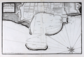 | Details | Ayrouard, Jacques | 1746 |
| Antique plan of the port of Civitavecchia, Italy |
|
Ayrouard, Jacques |
|
| 1746 |
| LOC:8 |
| $525.00 | Ayrouard--Jacques | Antique-plan-of-the-port-of-Civitavecchia--Italy | Plan of Civitavecchia, Italy also referred to as the "port of Rome", as it lies on the Tyrrhenian Sea, about 50 miles south of Rome. The antique chart is by Jacques Ayrouard (Marseilles ca. 1732- 1746) from a scarce atlas titled: "Recueil de Plusiers Plans des Ports et Rades et de Quelque Cartes Particulieres de la Mer Mediterranee". Identifies only a few features by name including "la Darce" or the old port, and significantly "les Chantiers des Galeres" or the boatyard where galleys were constructed and repaired.
<br></br>
In the attribution Ayrouard is described as "Pilot Real" or pilot of la Reale, the flagship of the French galley corps with a total complement of about 550 including 360 oarsmen and 100 soldiers. In their <i>Dictionnaire de la Marine</i> from 1702 Covens and Mortier explain: <div class="indenttextblock">"(Réale) is the name of the main galley of an independent kingdom, not of a tributary kingdom annexed to a greater one. The Réale, in France, is reserved for the general of the galleys and flies the royal ensign which distinguishes it from the others. This ensign is square in shape and red in colour, with golden fleurs-de-lys." <a href="http://www.ulmo.net/bateaux/reale/dico02.jpg" target="_blank"> (Internet)</a> </div>
Ayrouard was likely one of the last such pilots as the French Corps des Galeres was disbanded in 1748 and incorporated into the regular French sailing navy.
<br></br>
Little information exists on Ayrouard's background but like Henry Michelot, Ayrouard was a pilot of the French royal galley, the Reale, based in Marseille, France. However, Ayrouard's port plans and rare sea charts are very different from Michelot's earlier works. The much larger size (18"x11") and extensively shaded topography seen in this plan of Antibe are distinctive characteristics of Ayrouard's plans. Engraved by Louis Corne. Published with the royal privilege. |
| 4973 | 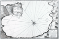 | Details | Ayrouard, Jacques | 1746 |
| Antique plan of Portoferraio Porto Ferraro Italy |
|
Ayrouard, Jacques |
|
| 1746 |
| LOC:0 |
| $425.00 | Ayrouard--Jacques | Antique-plan-of-Portoferraio-Porto-Ferraro-Italy | Fine copper-plate engraved 1746 antique port/harbor plan or chart of Porto Ferraro (Portoferraio), Italy by Jacques Ayrouard. Portoferraio is the largest city on the island of Elba, located in the Tyrrhenian Sea about 30 miles east of Corsica.
<br></br>
In the chart's attribution Ayrouard is described as "Pilot Real" or pilot of la Reale, the flagship of the French galley corps with a total complement of about 550 including 360 oarsmen and 100 soldiers. In their <i>Dictionnaire de la Marine</i> from 1702 Covens and Mortier explain: <div class="indenttextblock">"(Réale) is the name of the main galley of an independent kingdom, not of a tributary kingdom annexed to a greater one. The Réale, in France, is reserved for the general of the galleys and flies the royal ensign which distinguishes it from the others. This ensign is square in shape and red in colour, with golden fleurs-de-lys." <a href="http://www.ulmo.net/bateaux/reale/dico02.jpg" target="_blank"> (Internet)</a> </div>
Ayrouard was likely one of the last such pilots as the French Corps des Galeres was disbanded in 1748 and incorporated into the regular French sailing navy. Engraved by Louis Corne. |
| 5191 | 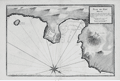 | Details | Ayrouard, Jacques | 1746 |
| Plan du Port Hercule Porto Ercole Tuscany |
|
Ayrouard, Jacques |
|
| 1746 |
| LOC:9 |
| $450.00 | Ayrouard--Jacques | Plan-du-Port-Hercule-Porto-Ercole-Tuscany | Original antique nautical chart or plan of the town and harbor of Port Hercule (Porto Ercole), Italy by Jacques Ayrouard (Marseilles ca. 1732- 1746). The plan is from Ayrouard's scarce sea atlas titled: "Recueil de Plusiers Plans des Ports et Rades et de Quelque Cartes Particulieres de la Mer Méditerranée". This engraved plan is of the old port at Porto Ercole which is located on the eastern side of the Monte Argentario promontory in the province of Grosetto, in the Tuscany region.
<br></br>
Like Henry Michelot, Jacques Ayrouard was a pilot of the French royal galley, the Reale, based in Marseille. However, Ayrouard's port plans are very different from Michelot's earlier works. The much larger size (18"x11") and extensively shaded topography in this plan are distinctive characteristics of Ayrouard's nautical plans. Plate 29. <br> </br> |
| 3585 | 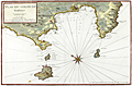 | Details | Ayrouard, Jacques | 1746 |
| Antique chart of the Gulf of Naples by Ayrouard |
|
Ayrouard, Jacques |
|
| 1746 |
| LOC:88 |
| $0.00 | Ayrouard--Jacques | Antique-chart-of-the-Gulf-of-Naples-by-Ayrouard | SOLD<br><br>
Beautifully colored antique nautical chart of the Bay of Naples, Italy by Jacques Ayrouard (Marseilles ca. 1746). From Ayrouard's scarce nautical atlas: "Recueil de Plusiers Plans des Ports et Rades et de Quelque Cartes Particulieres de la Mer Mediterranee".
<BR> </BR>
This fine small-scale copperplate-engraved chart covers the entire Bay of Naples, including Mount Vesuvius, Vigo, Sorrento, and the islands of Ischia (Iscle), Procida (Procita), and Capri (Cabrita). Numerous windmills, guard towers, and other structures are noted. Shows much of Italy's justly famous Amalfi Coast as far to the north as the vicinity of Positano and Praiano.
<BR> </BR>
Mount Vesuvius is shown erupting. According to one source, relatively severe eruptions of Vesuvius occurred in 1660, 1682, 1694, 1698, 1707, 1737. The 1737 event brought disaster to the town of Torre del Greco.
<BR> </BR>
Little information exists on Ayrouard's background but like <a style="color:#9BAFCB" rel="nofollow" href= "/MichelotBremondBackground.aspx">Henry Michelot</a>, Ayrouard was a pilot of the French royal galley, the Reale, based in Marseille. However, Ayrouard's port plans and charts are very different from Michelot's earlier works. The much larger size (17"x11") and the extensively shaded topography are distinctive characteristics of Ayrouard's plans.
<BR> </BR>
Large compass rose with fleur-de-lis. Plate 35. With the royal privilege. |
| 3586 | 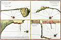 | Details | Ayrouard, Jacques | 1746 |
| Scarce Port Plan details near the Bay of Naples |
|
Ayrouard, Jacques |
|
| 1746 |
| LOC:88 |
| $475.00 | Ayrouard--Jacques | Scarce-Port-Plan-details-near-the-Bay-of-Naples | Beautifully colored antique detailed nautical plans of four areas near the Bay of Naples, Italy by Jacques Ayrouard (Marseilles ca. 1746). From Ayrouard's scarce nautical atlas: "Recueil de Plusiers Plans des Ports et Rades et de Quelque Cartes Particulieres de la Mer Mediterranee". Includes the breakwater/wharf in Naples; the port of Pozzuoli; and two views of the "Cote Romaine" or Roman Coast south of Terracina.
<BR> </BR>
Little information exists on Ayrouard's background but like <a style="color:#9BAFCB" rel="nofollow" href= "/MichelotBremondBackground.aspx">Henry Michelot</a>, Ayrouard was a pilot of the French royal galley, the Reale, based in Marseille. However, Ayrouard's port plans and charts are very different from Michelot's earlier works. The much larger size (17"x11") and the extensively shaded topography are distinctive characteristics of Ayrouard's plans.
<BR> </BR>
Plate 34. With the royal privilege. |
| 269 | 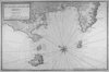 | Details | Ayrouard, Jacques | 1746 |
| Plan du Golfe de Naples |
|
Ayrouard, Jacques |
|
| 1746 |
| LOC:0 |
| $0.00 | Ayrouard--Jacques | Plan-du-Golfe-de-Naples | SOLD<br></br> Please search our site for "Ayrouard" for a similar engraving with beautiful hand-color..
<br></br>
Lovely antique nautical chart by Jacques Ayrouard (Marseilles ca. 1746) from a scarce nautical atlas: "Recueil de Plusiers Plans des Ports et Rades et de Quelque Cartes Particulieres de la Mer Mediterranee". |
| 569 | 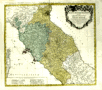 | Details | Homann Heirs | 1748 |
| Status Ecclesiastici Toscanae |
|
Homann Heirs |
|
| 1748 |
| LOC:66 |
| $290.00 | Homann-Heirs | Status-Ecclesiastici-Toscanae | Fine, large, hand-colored, copper-plate engraved antique map of Italy centered on Tuscany by the heirs of J. B. Homann. Includes Rome, Citavecchia, Ostia, Elba, Pisa, Ravenna, and the northern tip of Corsica. Leafy cartouche at top right decorated with the arms of Rome and Tuscany.
<br></br>
The map was published from Nuremberg, Germany in 1748 (dated at top).
<br></br>
Homann Heirs (also "Homannianis Heredibus" or "Homann Erben" or "Heritiers de Homann") was a company established after the death of the famous German cartographer Johann Baptist Homann to carry on the map publishing business of the firm he started in the early 1700's. The designation "Homann Heirs" appears on maps published by that successor firm from about 1730 to 1848. |
| 411 | 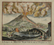 | Details | Anonymous | 1750 |
| A Prospect of Mount Vesuvius with its Irruption in 1630 |
|
Anonymous |
|
| 1750 |
| LOC:50 |
| $225.00 | Anonymous | A-Prospect-of-Mount-Vesuvius-with-its-Irruption-in-1630 | Hand colored engraving depicting the eruption of Mount Vesuvius near Naples, Italy more than a century earlier. From the April 1750 edition of Gentleman's Magazine. Features depicted include the catastrophic explosion of Vesuvius, the Torre del Greco (Greek Tower) covered with ashes, two barges on which several people saved themselves, and the bridge "la Nunciato". |
| 470 |  | Details | Delisle, Guillaume | 1750 |
| Title Page-Atlante Novissimo |
|
Delisle, Guillaume |
|
| 1750 |
| LOC:1 |
| $175.00 | Delisle--Guillaume | Title-Page-Atlante-Novissimo | Undated decorative copperplate title-page from Delisle's Atlas 'Atlante Novissimo'. The atlas was published from Venice, Italy in 1750. As the author's name is spelled 'Guglielmo' we assume this engraving is from an Italian edition of the atlas. Bottom vignette contains a view of St. Marks square in Venice with the Campanile to the left. |
| 838 | 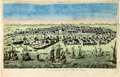 | Details | Anonymous | 1750 |
| Hand-colored Antique Vue d'Optique View of Venice, Italy |
|
Anonymous |
|
| 1750 |
| LOC:7 |
| $275.00 | Anonymous | Hand-colored-Antique-Vue-d-Optique-View-of-Venice--Italy | Hand colored copperplate engraved view of Venice, Italy from the mid 18th century. This Vue d'Optique, when viewed through the lens of a zograscope ( left-right reversed ) would have shown that city of islands as it would have appeared from the South looking slightly northwest across the Giudecca and San Giorgio Maggiore to Piazza san Marco.
<br></br>
Shown underway in the lagoon, in the Giudecca Canal, and in Saint Mark's Basin are numerous ships- galleys, xebecs, and square-rigged vessels , as well as dozens of Venice's signature gondolas. |
| 575 | 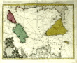 | Details | Homann Heirs | 1762 |
| Antique chart of the Mediterranean featuring Sicily Sardinia Corsica Malta Gozo |
|
Homann Heirs |
|
| 1762 |
| LOC:50 |
| $650.00 | Homann-Heirs | Antique-chart-of-the-Mediterranean-featuring-Sicily-Sardinia-Corsica-Malta-Gozo | Decorative antique chart of the southern boot of Italy with the islands of <strong>Corsica</strong> ( Corse ) , <strong>Sardinia</strong> ( Sardegna or Sardegna ), <strong>Sicily</strong> ( Sicilia ), <strong>Malta</strong>, <strong>Gozo</strong> and much more to the Gulf of Tunis and northern coast of Africa (Barbaria). Based on the work of Rizzi Zannoni. Dated in the top title to 1762. A highly decorative title cartouche at bottom left of this antique map contains angels carrying state coats of arms above symbols of war including a warship firing a salvo from its starboard side.
<br></br>
Published by the firm <strong>Homann Heirs</strong>. Homann Heirs (also "Homannianis Heredibus" or "Homann Erben" or "Heritiers de Homann") was a company established after the death of German cartographer J.B. Homann to carry on the map publishing business of the firm he started in the early 1700's. The designation "Homann Heirs" appears on maps published by that successor firm from about 1730 to 1848. |
| 199 | 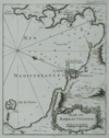 | Details | Bellin, Jacques Nicolas | 1764 |
| Plan de Bayes et Poussole |
|
Bellin, Jacques Nicolas |
|
| 1764 |
| LOC:0 |
| $0.00 | Bellin--Jacques-Nicolas | Plan-de-Bayes-et-Poussole | SOLD
<br></br>
Clean copy of this small 18th century antique chart of the Italian coast including the city of Pozzouli (Poussole) from La Petit Atlas Maritime. Coverage includes the Mediterranean coast from Cap Mizene to Cap Coroille. Highlights include a small volcano "Souffriere" and the island of Nizita south of Pozzouli. Tome 4. No. 85. |
| 410 | 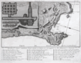 | Details | Morghen, Filippo | 1766 |
| Pianta del Cratere |
|
Morghen, Filippo |
|
| 1766 |
| LOC:8 |
| $190.00 | Morghen--Filippo | Pianta-del-Cratere | 18th century scarce copperplate engraved plan of the Phlegraean Fields (Campi Flegrei) near Pozzuoli west of Naples, Italy by Florentine artist Filippo Morghen in his "Views of Ruins in the Environs of Naples". <BR> </BR>
Noted geographic features include Capo di Posilipo, Miseno, Campana, Bacoli, Mare Morto, Lago Fusaro, Cuma, and Lago di Patria. This finely engraved plan contains inset plans of grottos in the vicinity including Grotta a Miseno, Grotta Lago Averno, and the Grotta a Cuma Superiore and Grotta a Cuma Inferiore. These geographical features and inset items and many more are among the 40 places of interest denoted by numbers on the plan and explained in a legend at the bottom of the engraving. Number 1. "Anno 1766". |
| 4830 | 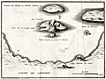 | Details | Ransonnette, Nicolas | 1783 |
| Scarce antique map of the Bay at Santorini, Italy |
|
Ransonnette, Nicolas |
|
| 1783 |
| LOC:13 |
| $175.00 | Ransonnette--Nicolas | Scarce-antique-map-of-the-Bay-at-Santorini--Italy | Interesting antique engraved map of the bay and islands of Santorini (Santorin), Italy. Shows the central portion of the volcanic caldera on "Isle Nouvelle" as emitting steam or smoke, an indication of recent and continuing volcanic activity on the island. Shows the Chateau de Searo. From "Illustrations de Lettres édifiantes et curieuses" by Nicolas Ransonnette (1745-1810). Tome 1, Page 78. |
| 5286 | 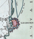 | Details | Luffman, John | 1801 |
| Chart of Leghorn, Italy (Livorno) engraved for Luffman's Select Plans |
|
Luffman, John |
|
| 1801 |
| LOC:7 |
| $225.00 | Luffman--John | Chart-of-Leghorn--Italy--(Livorno)-engraved-for-Luffman-s-Select-Plans | Copper-plate engraved chart or map of the port of Livorno (Leghorn), Italy. In the 16th-century Leghorn was under the control of the Medici family who greatly improved the harbor. Leghorn was free and neutral from 1691 until 1867 when it was incorporated into the nation of Italy.
<br></br>
The chart shows the Mellora Shoal and Mellora Tower west of Livorno; the Tower of Marzocco, the Colombrone River, and numerous hydrographic features including anchorages, navigation hazards, and depth soundings.
<br></br>
Description at the bottom reads in part:
<div class="indenttextblock">
"The Port of Leghorn is a free port in the Mediterranean Sea, in the Dominions of the Grand Duke of Tuscany in Italy. It is a place of considerable trade; 46 miles west of Florence & 145 miles North West of Rome."
</div>
<br />
From "Luffman's Select Plans of the Principal Cities, Harbors, Forts etc. in the World". Engraved and published by John Luffman, No. 28 Little Bell Alley, Coleman Street, January 1, 1801. Vol 1. Number 73.
<br></br> |
| 866 | 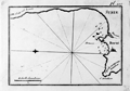 | Details | Allezard, Jean Joseph | 1817 |
| Antique nautical chart of Beirut, Lebanon and approaches |
|
Allezard, Jean Joseph |
|
| 1817 |
| LOC:4 |
| $135.00 | Allezard--Jean-Joseph | Antique-nautical-chart-of-Beirut--Lebanon-and-approaches | Antique maritime chart of the area around and including Beirut, Lebanon, then considered part of Syria ( "Syrie" ). This old copperplate-engraved map extends from Cape Danthon to the east past Beirut and then follows the coast northward until approximately the town of Juniyah. A few soundings and anchorages are defined. Sea charts of ports on the Levantine coast of the Eastern Mediterranean from this time period are somewhat scarce.
<br></br>
One of 163 plates of ports on the Mediterranean, Adriatic and Black seas from Allezard's atlas "Recueil de 163 des principaux plans des ports et rades de la Mediterranée, dont 40 ont été derniérement publiés par Jean Joseph Allezard ancien capitaine de marine et plusieurs des autres corrigés" . This atlas was a re-issue of Joseph Roux's atlas published from Marseille in several editions beginning in 1764. Published by Joseph Gamba from Livorno, Italy. Plate 119. |
| 865 |  | Details | Allezard, Jean Joseph | 1817 |
| Antique nautical plan of Venice, Italy and lagoons |
|
Allezard, Jean Joseph |
|
| 1817 |
| LOC:4 |
| $175.00 | Allezard--Jean-Joseph | Antique-nautical-plan-of-Venice--Italy-and-lagoons | Antique harbor plan of Venice, Italy and its nearby islands, canals, and villages. The copperplate-engraved map extends from Chioggia ( "Chiozza" ) in the south past the islands of Lido and Malamocco. Venice is shown as an archipelago of about 30 inhabited islands in the center of the lagoon. Some of the noted towns and villages surrounding Venice include Ville Franche, Termine, Palestrina, Bolta, St. Ange, St. George, Muran ( Murano ), Vignole, Neuveau Lazaret, and St. Francis du Desert. Soundings and navigational aids are absent from this small nautical chart. The primary man-made feature of note is the hospital at the east of Venice.
<br></br>
One of 163 plates of ports on the Mediterranean, Adriatic and Black seas from Allezard's atlas "Recueil de 163 des principaux plans des ports et rades de la Mediterranée, dont 40 ont été derniérement publiés par Jean Joseph Allezard ancien capitaine de marine et plusieurs des autres corrigés" . This atlas was a re-issue of Joseph Roux's atlas published from Marseille in several editions beginning in 1764. Published by Joseph Gamba from Livorno, Italy. Plate 81. |
| 5467 |  | Details | Smyth, William Henry | 1827 |
| Complete 4-sheet set of Sardinia Capt W H Smyth |
|
Smyth, William Henry |
|
| 1827 |
| LOC: |
| $6,000.00 | Smyth--William-Henry | Complete-4-sheet-set-of-Sardinia-Capt-W-H-Smyth | Exceedingly rare and complete set of four nautical charts of the Mediterranean island of Sardinia by Captain William Henry Smyth based on his hydrographic survey of Sardinia for the Royal Navy during 1823 and 1824. Sardinia is the second largest island in the Mediterranean and one of 20 regions of Italy.
<br></br>
Whatman Turkey Mill watermark (date illegible) on one of four sheets. Complete set of four, ea. ~ 17" x 24".
Elson and Graves are co-authors for all four charts. Slater is credited on the chart of the entire Island.
<br></br>
In 1828 Smyth published a book on the political history of Sardinia- <b>"Sketch of the present state of the Island of Sardinia"</b> [1]. Smyth references a four chart set in the introduction to his "Sketch": <div class="indenttextblocksingle">… in conclusion it may not be unnecessary to state that my <strong>Nautical Survey of Sardinia</strong> has just been published, on four sheets, at the Hydrographical office of the Admiralty. As no pains have been spared in the construction, it is hoped that these charts will be found equal to every purpose of Navigation. [Smyth's chart titles are used here:] </br><div class="indenttextblocksingle">
<ul style="list-style-type: circle;">
<li>A general chart of the Island, "The Island of Sardinia"</li>
<li>"The South Coast of Sardinia"</li>
<li>"The North East Coast of Sardinia"</li>
<li>"The Gulf of Asinara on the N. W. Coast of Sardinia"</li></div>
</ul>
</div>
Small traces of manuscript pencil notations attesting to real-life use of this chart while at sea. Well-executed early to mid 20th-century conservation with the chart laid to linen and protected via a thin-film lamination process. After experience with the lamination process over time, lamination is not now considered to be a effective document conservation procedure.
<br></br>
[1] Captain William Henry Smyth. London. John-Murray. 351 pp.
<br></br>
[Sardegna] |
| 5256 | 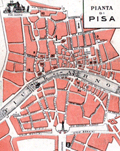 | Details | Jonni, G. | 1915 |
| Pianta di Pisa |
|
Jonni, G. |
|
| 1915 |
| LOC:14 |
| $75.00 | Jonni--G- | Pianta-di-Pisa | Map of Pisa, Italy for Jonni's Grand Hotel Minerva ca 1915. Located on verso of a folding trade card for the hotel. No phone number, but electric lights … estimated ca. 1915 when adoption rates for the telephone in Italy were about 5% of the rate in the U.S.A. |
| 6780 | 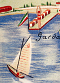 | Details | Ministero della Cultura Popolare | 1935 |
| Pictorial map of the province of Verona, Italy |
|
Ministero della Cultura Popolare |
|
| 1935 |
| LOC:400 |
| $395.00 | Ministero-della-Cultura-Popolare | Pictorial-map-of-the-province-of-Verona--Italy | An attractive lithographed touristic pictorial map of the Verona region of Italy on the verso of an 8-panel folding brochure for that region. Includes Lake Garda and Monte Baldo. Designed by F. Poggi and published ca. 1935 by Italy's Ministero della Cultura Popolare. Rare, no copy is found online.
<br><br>
The map shows images of duck hunters, skiers, swimmers, hikers, soldiers, and winemakers set on a background with local road and rail networks connecting Verona to the rest of Italy and Europe, especially to many nearby old cities. <br><br>
<div id="6780a" align="center">
<a title=""></a>
<img id="6780" src="/ZoomifyImages/SC_6780/SC_6780_detail_1.jpg" alt="Lake Garda detail from a pictorial map of the province of Verona, Italy" width="340"/> <br><br> <font size="-2">Lake Garda coastal boating detail.</font>
</div><br>
Recto with photographs of local attractions. Printed by Pizzi & Pizio - Milano-Roma. French text description at right.><br><br>
<div id="6780b" align="center">
<a title=""></a>
<img id="6780b" src="/ZoomifyImages/SC_6780/SC_6780_detail_2.jpg" alt="Lake Garda coastal and Monte Baldo detail from a pictorial map of the province of Verona, Italy." width="340"/> <br><br> <font size="-2">Lake Garda and Monte Baldo detail .</font>
</div><br> |
| 7893 | 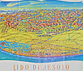 | Details | Oberbacher, Hans | 1958 |
| Lido di Jesolo beach near Venice Italy |
|
Oberbacher, Hans |
|
| 1958 |
| LOC:86 |
| $255.00 | Oberbacher--Hans | Lido-di-Jesolo-beach-near-Venice-Italy | Fine birds-eye view, "Lido di Jesolo", with Venice, Italy at the left. By Hans Oberbacher. 1958.
<br><br>
Lido di Jesolo, a popular seaside resort town, is situated within the metropolitan city of Venice, Italy. It is well known for its long sandy beach and vibrant nightlife, and it serves as a popular tourist destination, especially during the summer months. Lido di Jesolo is situated on the Adriatic coast close to Venice, making it a convenient location for visitors looking to enjoy both the beach and the historic city of Venice.
<br><br>
The region surrounding Jesolo has been featured in cartographic works dating back to the 14th century or earlier, crafted by renowned cartographers such as Pietro Vesconte, Fra Mauro, Benedetto Bordone, and Vincenzo Maria Coronelli, among others. These prior charts provide insight into the development of the Venetian Lagoon over time.
<br><br>
Jesolo has a history that dates back to ancient Roman times when it was known as Equilium, meaning "city of horses." The area was largely abandoned during the Middle Ages due to the decline of the Roman Empire and encroachment of the surrounding marshlands.
<br><br>
During the era of the Republic of Venice, which lasted from the 8th to the 18th century, the Venetians began to drain and reclaim the land for agriculture and fishing. The first settlements were established in the 19th century, and the town was renamed Cavazuccherina.
<br><br>
The opening of the first beach resort in 1911 marked the beginning of tourism in Lido di Jesolo. However, it was not until the post-World War II period that the town experienced a significant boom in tourism. During the 1950s and 1960s, rapid development and urbanization transformed Lido di Jesolo into one of the most popular seaside resorts in Italy. |
| 6585 | 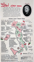 | Details | Mama Leone | 1960 |
| Large menu for Mama Leone's Restaurant in NYC |
|
Mama Leone |
|
| 1960 |
| LOC:57 |
| $225.00 | Mama-Leone | Large-menu-for-Mama-Leone-s-Restaurant-in-NYC | Large original menu from Mama Leone's restaurant in New York City circa 1960. Colorful pictorial map of Italy at center at center divided into administrative regions with each region promoting one or more of Mama Leone's wine offerings, for example Frecciarossa, Brachetto, Lambrusco, or Verdiccio or another of the available wines. Mama Leone's restaurant closed in 1994.
<br><br>
Inset photo of Mama Leone at top right. |
| 4769 | 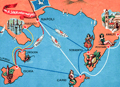 | Details | Societa Partenopea di Navigazione | 1970 |
| Pictorial map of Amalfi Coast and Bay of Naples. |
|
Societa Partenopea di Navigazione |
|
| 1970 |
| LOC:0 |
| $35.00 | Societa-Partenopea-di-Navigazione | Pictorial-map-of-Amalfi-Coast-and-Bay-of-Naples- | Decorative pictorial map of the Bay of Naples and Amalfi Coast area in Italy ca. 1970. Includes the islands of Capri, Ischia, and Procida linked with mainland towns of Pozzuoli, Napoli, Sorrento, Positano, and Amalfi.
<br></br>
This colorful small map was published by the Italian transportation service SPAN, the Societa Partenopea di Navigazione. Art by Cassese. With the SPAN flag and the phrase "con la SPAN verso mete felici" or Google-translated from Italian as "with SPAN towards happy destinations."
<br></br>
Verso with a complete SPAN timetable in English. |