| | Thumbnail | | Creator | Date | Title / Author / Date / Location | Price | | | Description |
| 5197 | 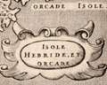 | Details | Porcacchi, Tomasso | 1572 |
| Isole Hebride et Orcade Scotland |
|
Porcacchi, Tomasso |
|
| 1572 |
| LOC:7 |
| $375.00 | Porcacchi--Tomasso | Isole-Hebride-et-Orcade-Scotland | Authentic copperplate-engraved antique map (1572) of the Hebrides and Orcades Islands off the mainland of Scotland. This map of the Orcades and Hebrides was drawn by Tomasso Porcacchi and was engraved by Girolamo Porro.
<br></br>
Printed in Tomasso Porcacchi's "Isolario" or island book "L'Isol Piu Famose Del Mondo". That work contains a number of finely engraved maps of islands and the continents at a reduced scale. Porcacchi (1530-1585) was born in Tuscany to a poor family and first settled in Florence. He wrote about history, geography, and archaeology and later published the Isolario from Venice, Italy in three editions beginning in 1572. |
| 905 | 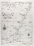 | Details | Dudley, Robert | 1646 |
| Fine Antique Nautical Chart of Scotland with Edinburgh |
|
Dudley, Robert |
|
| 1646 |
| LOC:89 |
| $2,400.00 | Dudley--Robert | Fine-Antique-Nautical-Chart-of-Scotland-with-Edinburgh | Rare and extremely desirable first edition nautical chart of the east coast of Scotland including coastline for all or part of the following Scottish council areas : the Lothians, Fife, Angus, Aberdeenshire, Moray ("Costa di Muray"), and Highland.
<br></br>
This antique sea chart is from the <b>Dell' Arcano del Mare</b> published from Florence in 1646 by Sir Robert Dudley, the illegitimate son of Robert Dudley, 1st Earl of Leicester and a close friend of Elizabeth I. Dudley was an adventurer, explorer, naval advisor to the Grand Duke of Tuscany, and publisher. The charts have a unique sparse Baroque style that is complemented by very high quality calligraphy and engraving (by Lucini). In addition to the quality of execution, charts from the Arcano del Mare are highly sought after for their singularity- as the <b>first maritime atlas to cover the entire globe</b>, the first world atlas published by an Englishman, and the first maritime atlas to use the Mercator projection.
<br></br>
There are many named settlements in Scotland on this old chart including: Dunbar, Edinburgh ("Edenburgh"), Dundee ("Donde"), <b>St. Andrews or "S. Andrea" (of golfing legend)</b> , Aberdeen ("Alberden"), Peterhead ("Peter Polle"), Spey Bay ("Spyn"), Rosemarkie ("Rosemark") . Kinloss ("Killos"). At the far north the chart ends at Cromarty ("C. di Comar").
<br></br>
In much the same way as Wagenhaer exaggerated certain features on his charts, so too the mouths of firths, bays, and rivers are not to scale. By depicting them at a larger scale, Dudley is able to obtain some of the benefits of a large-scale chart in what is otherwise a small-scale chart of the area. |
| 4728 | 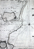 | Details | Adair, John | 1693 |
| Very Rare Antique Chart of Montrose, Angus, Scotland |
|
Adair, John |
|
| 1693 |
| LOC:88 |
| $1,950.00 | Adair--John | Very-Rare-Antique-Chart-of-Montrose--Angus--Scotland | Original antique navigation chart of Montrose (Montross), Scotland by civilian marine surveyor and cartographer John Adair (1655 - 1722). Maps by Adair seldom are found for sale.
<br></br>
Adair was the foremost surveyor of Scotland in the late 1600s, and was appointed to conduct a hydrographical survey of the Scottish coast by a special act of Scottish Parliament to be funded by a tax on vessels entering Scottish ports. The tax proved unpopular and Adair's survey was underfunded and slow in progress. Thus, this chart, engraved in 1693, was not printed until 10 years later in 1703.
<br></br>
Montrose lies along the eastern coast of Scotland about 50 miles north of Dundee. The chart includes small images of local fishing vessels.
<br></br>
This rare chart of the Scottish coast, although compiled and engraved in 1693, was published in 1703 along with 5 other charts in Adair's rare sea atlas "The Description of the Sea- Coast and Islands of Scotland With Large and Exact Maps, for the Use of Seamen" [1]. These other charts in Adair's atlas are titled as below:
<div class="indenttextblock">
1) General chart of Scotland made on a voyage by James the Fifth.</BR>
2) St. Abb's Head to Sunderland Point.</BR>
3) Firth of Forth.</BR>
4) Frith and River Tay.</BR>
5) Red Head to Aberdeen including Montrose.</BR>
</div>
</BR>
The AMPR shows no record of this chart sold individually and records only one copy of Adair's atlas sold (2010).
<br></br>
[1] Robinson, A.H.W. 'Marine Cartography in Britain'. Leicester University Press. 1962. pp. 162; . |
| 943 | 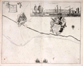 | Details | Collins, Greenvile | 1750 |
| Antique chart of the coast near Leith, Scotland |
|
Collins, Greenvile |
|
| 1750 |
| LOC:0 |
| $325.00 | Collins--Greenvile | Antique-chart-of-the-coast-near-Leith--Scotland | Antique chart of the city of <b>Leith, Scotland</b> (North and South Leith) and the surrounding coastline by <b>Greenville Collins</b>. With an attractive inset view "Prospect of Leith from the East" showing Leith Harbour, with square-rigged sailing ships anchored behind the pier. With one of the earliest available street plans of Leith, showing the bridge across the Water of Leith linking the two halves of the city. That bridge, originally built in the late 15th century, was demolished in 1780.
<br></br>
From one of the many editions of Greenville Collin's 'Great Britain's Coasting Pilot', published from 1693 to 1792. At top left angels hover holding a sheet on which is drawn a elevation view of a castle with three domed towers and three gates, each with a portcullis. Suggested by one writer to be a coat-of-arms, the actual meaning of the image is unkown. |
| 1287 | 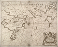 | Details | Collins, Greenvile | 1750 |
| Antique Chart of the Shetland Islands |
|
Collins, Greenvile |
|
| 1750 |
| LOC:0 |
| $156.00 | Collins--Greenvile | Antique-Chart-of-the-Shetland-Islands | Antique sea chart of the eastern portion of the <b>Shetland island of the "Mainland"</b>, a part of Scotland. Includes the islands of Bressay (Brassey) and Noss (Nos). Noted are the villages of Lerwick, Heoghan, Laxford and many more.
<br></br>
Decorative antique eighteenth century copperplate nautical sea chart, printed on thick paper ca. 1750. Attribution for engraving at bottom left to "H. Moll"- Herman Moll.
<br></br>
From Captain Greenville or Greenvile Collins "Great Britain's Coasting Pilot: being a new and exact survey of the sea-coast of England and Scotland from the river of Thames to the westward and northward ...".
<br></br>
Greenville Collins was an officer of the Royal Navy and prominent hydrographer who was commissioned by King Charles II in 1676 and appointed by Samuel Pepys to chart the coasts of Great Britain. The resulting atlas - Great Britain's Coasting Pilot - was the first original sea atlas to be produced by an Englishman. |
| 1316 | 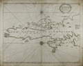 | Details | Collins, Greenvile | 1750 |
| Antique Chart of the South Shetland Islands |
|
Collins, Greenvile |
|
| 1750 |
| LOC:0 |
| $240.00 | Collins--Greenvile | Antique-Chart-of-the-South-Shetland-Islands | Old engraved antique sea chart of the southern portion of the <b>Shetland Islands</b>, a part of Scotland. Includes the islands of Tronzo, Nebra, West Buro, Bressay (Brassey) and Noss (Nos). Inset chart of Catford Roe with soundings and anchorages noted.
<br></br>
A decorative antique eighteenth century copperplate nautical sea chart, with an authentic sea-worn appearance, printed on thick paper ca. 1750.
<br></br>
From Captain Greenville or Greenvile Collins "Great Britain's Coasting Pilot: being a new and exact survey of the sea-coast of England and Scotland from the river of Thames to the westward and northward ...".
<br></br>
Greenville Collins was an officer of the Royal Navy and prominent hydrographer who was commissioned by King Charles II in 1676 and appointed by Samuel Pepys to chart the coasts of Great Britain. The resulting atlas - Great Britain's Coasting Pilot - was the first original sea atlas to be produced by an Englishman. |
| 825 | 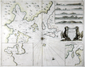 | Details | Collins, Greenvile | 1750 |
| Antique nautical chart of the Orkney Islands |
|
Collins, Greenvile |
|
| 1750 |
| LOC:57 |
| $550.00 | Collins--Greenvile | Antique-nautical-chart-of-the-Orkney-Islands | Antique sea chart of the North Sea, the Orkney Islands, Wide Firth, Hoy Sound and Deer Sound. The islands shown on this scarce, old British chart include parts of the Mainland ("Pomona"), Shapinsay, Gairsay, Wyre, Egilsay, and Rousay. With 5 coastal elevation views including: Copinsha to Mulhead; Faire Isle; the Maiden Papps of Carness; Dunkins Bay Head.
<br></br>
Title cartouche on this decorative chart of the Orkneys is held up by a pair of fierce sea eagles clutching a rag between their beaks. <div class="indenttextblock">Sea eagles have a long history in Orkney. The Bronze Age burial tomb at Isbister, South Ronaldsay (the ‘Tomb of the Eagles’) famously contains their bones, while a Pictish symbol stone found at the Knowe of Burrian, Harray, features a beautifully carved bird.
<br></br>
Sea eagles became extinct across the UK in the early 19th century due to combination of widespread habitat loss and human persecution, with the last bird shot in Shetland in 1918. (<b>Sea Eagles Nest in Orkney after 142-year Absence</b>". Royal Society for the Protection of Birds. <a href="http://www.rspb.org.uk/community/placestovisit/orkney/b/orkney-blog/archive/2015/04/16/sea-eagles-nest-in-orkney-after-142-year-absence.aspx">Internet.</a> June 19, 2015)</div>
</br>
Date in the title cartouche was largely erased from the copper engraving plate but remains faintly visible as 1688. This sheet is probably a later edition (estimated 1750), explaining the erasure. From one of the many editions of Greenville Collin's 'Great Britain's Coasting Pilot', published from 1693 to 1792. |
| 262 | 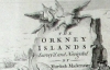 | Details | Mackenzie, Murdoch (Senior) | 1750 |
| Survey of the Orkney and Lewis Islands. (Atlas of 8 folio plates) |
|
Mackenzie, Murdoch (Senior) |
|
| 1750 |
| LOC:0 |
| $5,655.00 | Mackenzie--Murdoch-(Senior) | Survey-of-the-Orkney-and-Lewis-Islands--(Atlas-of-8-folio-plates) | This important, intact, and scarce folio-sized antique atlas of 8 plates is a landmark in cartography by Orkney native Murdoch Mackenzie Senior (1712 - 1797). This antique nautical atlas of the Orkney Islands, published in 1750 is Mackenzie's first published work and is considered to be the most accurate survey in Britain up to the mid 18th century. </br> </br>
<strong><a style="color:#9BAFCB" href= "/MackenzieAtlasViewer.aspx">[ Browse the entire atlas ]</a></strong> </br> </br>
In 1962 A.G.W. Robinson wrote about the unique characteristics of Mackenzie's first charts: "Some of the conventions he adopted, for example showing bottom deposits by a letter under the relevant sounding, are still in use on present day charts."
<br></br>
Contents include Title Page, Subscriber list, A 14 page History of the Orkneys, 8 charts of the Orkneys, Pomona, and the Lewis.
<br></br>
Reference: Robinson, A.H.W. 'Marine Cartography in Britain'. Leicester University Press. 1962. pp. 60-70. |
| 4956 | 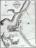 | Details | Wood, John | 1821 |
| Rare Plan of the Town and Harbour of Stornaway Lewis Island |
|
Wood, John |
|
| 1821 |
| LOC:64 |
| $1,999.39 | Wood--John | Rare-Plan-of-the-Town-and-Harbour-of-Stornaway-Lewis-Island | Very scarce antique map of the Harbor at Stornaway on the Island of Lewis, part of the Outer Hebrides Islands of Scotland. An exceptional finely-engraved example of an early 19th century harbor map. By John Woods from his Town Atlas to accompany his "Descriptive Account of the Principal Towns of Scotland…"
<br></br>
With a decorative smaller-scale inset Plan of the Town and Harbor of Stornaway and Projected Improvements. Notable features of the inset plan include Seaforth Lodge, Gallow Hill, Anish, Sandwich Bay, Big Rock, and Sandwich Hill.
<br></br>
Wood described Stornaway as
<div class="indenttextblocksingle">"a considerable thriving town in the Island of Lewis, in the Parish of that name and shire of Ross. The old part of the Town is situated at the head of the Loch of Stornaway, on a point or ness of land jutting into it; the newer parts of the Town stretch to the north and south of this point, along the margins of the Loch." (ibid pp. 545-547).</div> |
| 6521 | 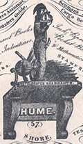 | Details | Nautical Warehouse | 1830 |
| Rare trade card Nautical Warehouse Leith Scotland harbor map |
|
Nautical Warehouse |
|
| 1830 |
| LOC:300 |
| $375.00 | Nautical-Warehouse | Rare-trade-card-Nautical-Warehouse-Leith-Scotland-harbor-map | Rare lithographed trade card c. 1830 for the Nautical Warehouse in Leith, Scotland. 4.5" x 3". As a logo a naval officer ("the Little Midshipman") is shown with a sextant taking a sighting atop a bracket shelf bearing the name "Hume."
<br><br>
Verso with a plan of Leith Harbor. The plan shows the East and West piers, a Martello Tower offshore, two wet docks and a small number of depth soundings leading to the entrance into the harbor between the two piers. The map includes an arrow showing the set off the ebb tide, an important consideration for mariners entering the harbor given the small entrance.
<br><br>
Recto reads:
<div class="indenttextblocksingle">
AT THE NAUTICAL WAREHOUSE 57 SHORE, Sign of the NAVAL OFFICER are sold Charts of North Sea, Baltic, Atlantic, English, and St. Georges Channel &c
</div>
The trade card goes on to list many of the items sold at the Nautical Warehouse:
<div class="indenttextblocksingle">
<ul style="list-style-type: circle;"></li>
<li>Nories, Riddles, and Moore's Navigations</li>
<li>Bibles</li>
<li>Tonnage tables</li>
<li>Mathematical instruments</li>
<li>Log books</li>
<li>Coaster's guides</li>
<li>Shipmaster's Assistant</li>
<li>Parallel Rules</li>
</ul>
</div>
Lithographed by Hume. |
| 6657 | 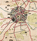 | Details | Pilcher, R. Stuart | 1926 |
| Pictorial map of Edinburgh roads and tramways Scotland |
|
Pilcher, R. Stuart |
|
| 1926 |
| LOC: |
| $275.00 | Pilcher--R--Stuart | Pictorial-map-of-Edinburgh-roads-and-tramways-Scotland | A scarce and graphically interesting pictorial map of Edinburgh and Leith, Scotland, the "Edinburgh Corporation Tramways & Motors" map published 1926 with tramway routes in red and motor bus routes shown in blue. R. Stuart Pilcher, Tramways Manager. Printed by Robert Mitchell and Sons Lithographers, Edinburgh. Verso with cover of Edinburgh skyline and numerous advertisements.
<br><br>
A graphically commanding map of Edinburgh, the core of the city displayed in a circle with black overtones and colorful motorways radiating outwards past Edinburgh's green spaces- cemeteries, parks, public gardens, and golf courses which include:
<div class="indenttextblocksingle">
<ul style="list-style-type: circle;">
<li>Craigentinny Golf Course</li>
<li>Leith Links</li>
<li>Craigmiller Park Golf Course</li>
<li>Bruntsfield Golf Course</li>
<li>Murrayfield Golf Course</li>
<li>Prestonfield Golf Course</li>
<li>Liberton Golf Course</li>
</ul>
</div>
This pictorial map of Edinburg contains numerous inset sketches of important local buildings including:
<div class="indenttextblocksingle">
<ul style="list-style-type: circle;">
<li>City Poorhouse</li>
<li>Redford Barracks</li>
<li>Merchiston Castle </li>
<li>Dan Steworth College</li>
<li>Royal Observatory</li>
<li>Fettes College</li>
<li>Leith Public Health Hospital</li>
<li>Holyrood Castle</li>
</ul>
</div> |
| 5433 | 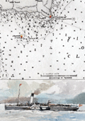 | Details | Anonymous | 1950 |
| Map of Rothesay Sound with watercolor side-wheel steamer. |
|
Anonymous |
|
| 1950 |
| LOC:78 |
| $160.00 | Anonymous | Map-of-Rothesay-Sound-with-watercolor-side-wheel-steamer- | Attractive, offset lithographed chart of Rothesay Sound and the Firth of Clyde, Scotland decorated with a small manuscript watercolor of a side-wheel steamboat. The chart is undated but probably 20th century after an earlier chart. Aids to navigation are highlighted in red and yellow.
<br></br>
The steamboat is unnamed but probably the <strong>Duchess of Fife</strong>, built and launched by Fairfield Shipbuilding and Engineering Company in May 1903. The Duchess of Fife was owned by the Caledonian Steam Packet Company and except for use during WWI and WWII, spent her career serving passenger routes in the Firth of Clyde.
<br></br>
Anonymous but initials "E.S." at bottom right corner. |