| | Thumbnail | | Creator | Date | Title / Author / Date / Location | Price | | | Description |
| 1009 | 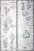 | Details | Depot de la Marine | 1841 |
| Antique French chart of the Maldive Islands |
|
Depot de la Marine |
|
| 1841 |
| LOC:0 |
| $0.00 | Depot-de-la-Marine | Antique-French-chart-of-the-Maldive-Islands | SOLD
<br></br>
Fine antique nautical chart of the Maldive islands, a island country and archipelago located in the Indian Ocean. This large old chart "Carte des Isles Maldives" was published by the French Depot de la Marine in 1841 (dated within) based on hydrographical data from Moresby and Powell, both officers in the British East India Company.
<br></br>
With a blue ink octagonal overstamp from the seller Antoine Roux, fils. (probably Mathieu-Antoine Roux 1799-1872) from Marseille, France. Roux was a hydrographer and painter with premises at "Quai Rive l'avenue Pres le Pharmacien in Marseille. " The Roux family was active in Marseille as hydrograpers and marine painters over at least three generations beginning with Joesph Roux. Number 942. |