| | Thumbnail | | Creator | Date | Title / Author / Date / Location | Price | | | Description |
| 6515 | 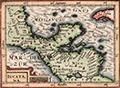 | Details | Bertius, Petrus | 1616 |
| Fine 1616 map of Mexico, Yucatan, Nicaragua and offshore islands |
|
Bertius, Petrus |
|
| 1616 |
| LOC:78 |
| $275.00 | Bertius--Petrus | Fine-1616-map-of-Mexico--Yucatan--Nicaragua-and-offshore-islands | Attractive original engraved map of the Yucatan Peninsula (Iucatana), Southern Mexico and Nicaragua by Petrus Bertius.
<br><br>
Petrus Bertius' 1616 map of the Yucatan Peninsula (Iucatana) and a portion of Central America is hand colored with attractive hachuring in the oceans that provides an interesting dimensionality to this scarce artifact.
<br><br>
Very scarce original reduced-size version created by Bertius in 1616 to meet the demands of a growing and cost conscious market. This very fine map covers a wide area that includes the western portion of Cuba, northern Nicaragua, Honduras, the Yucatan Peninsula and southern Mexico (Nova Hispanie Pars). |
| 6640 | 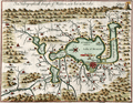 | Details | Gemelli Carreri, Giovanni Francesco | 1704 |
| Early map of Mexico City with Lakes and Causeways by Gemelli |
|
Gemelli Carreri, Giovanni Francesco |
|
| 1704 |
| LOC:3 |
| $525.00 | Gemelli-Carreri--Giovanni-Francesco | Early-map-of-Mexico-City-with-Lakes-and-Causeways-by-Gemelli | Original, copper-plate engraved and hand-colored map of the Valley of Mexico by Giovanni Francesco Gemelli Carreri (Gemelli) after Enrico Martinez and Adrian Boot (1). Scarce. North is oriented to the left.
<br><br>
Shows lakes, rivers, streams, and mountains in the Valley of Mexico along with numerous villages and towns. Nascent Mexico City or Tenochtitlán, is shown to lie in lower Lake Texcoco connected to the mainland by seven causeways. From an English-language publication of A Voyage Around the World (1699), probably A. and J. Churchill, 1704.
<br><br>
(1) Connolly, Patricia and Roberto Mayer. Vingboons, Trasmonte and Boot: European Cartography of Mexican Cities in Early Seventeenth Century. Imago Mundi. January, 2009. |
| 875 | 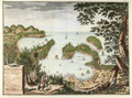 | Details | Valentijn, Francois | 1724 |
| Antique Dutch View of Acapulco Harbor in Mexico |
|
Valentijn, Francois |
|
| 1724 |
| LOC:0 |
| $0.00 | Valentijn--Francois | Antique-Dutch-View-of-Acapulco-Harbor-in-Mexico | SOLD
<br></br>
Fascinating antique panoramic view of the harbor of <b>Acapulco, Mexico</b> ("Aquapulco") from the early eighteenth century. This copperplate-engraved view has a legend at bottom left corner keyed to six locations on the scene:
<div class="indenttextblock">
<ul>
<li>Acapulco village</li>
<li>Fort San Diego (with latitude and longitude coordinates)</li>
<li>Grote mont. (harbor entrance)</li>
<li>Punta el Grifo</li>
<li>Kleyne mont. (channel between the mainland and la Roqueta island)</li>
<li>Haven van Marques (Puerto Marques Bay)</li>
</ul>
</div>
This colorful old view of the Acapulco area is by <b>Francois Valentijn</b> (or Valentyn) from 'Oud en Nieuw Oost Indien' published from Amsterdam in 1724 by Joannes van Braam. Valentijn ( 1666–1727 ) was a Dutch minister and naturalist who worked in the East Indies for the V.O.C. (Vereenigde Oost-Indische Compagnie). It is likely that Valentijn's access to V.O.C. maps and documents provided much source material for the eight volumes with over one thousand engravings. However, the basis for this relief map of Acapulco is an earlier watercolor by Dutch artist Johannes Vingboons who derived his work from drawings made in New Spain by Juan Gómez de Trasmonte and Adrian Boot before 1628.
<div class="indenttextblock"> (Connolly, Priscilla. "Vingboons, Trasmonte and Boot: European Cartography of Mexican Cities in the Early Seventeenth Century". 2014. <a href="http://www.researchgate.net/publication/249029290_Vingboons_Trasmonte_and_Boot_European_Cartography_of_Mexican_Cities_in_the_Early_Seventeenth_Century">Internet</a>)</div>
<br></br>
Two interesting graphical elements are the compass atop the title block at left which gives the orientation of the site and also in the far right bottom corner is a barely visible image of a woodsman with axe, removing a limb from the tall tree. |
| 3593 | 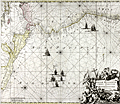 | Details | Ottens, Ranier and Joshua | 1745 |
| Spectacular antique chart of Mexico, Central America and South America |
|
Ottens, Ranier and Joshua |
|
| 1745 |
| LOC:51 |
| $1,150.00 | Ottens--Ranier-and-Joshua | Spectacular-antique-chart-of-Mexico--Central-America-and-South-America | Copper-engraved sea chart oriented with north to the left, showing the Pacific Ocean from Xalisco, Mexico, to Puerta Bairres in Chile (including Yucatan, Central America, the Western Caribbean and the Galapagos Islands). Columbia is shown in its entirety, along with a small piece of Venezuela. Includes well over 125 place names arranged in Portolan style. Finely engraved title cartouche with conquistadors, slaves, and putti set into an allegorical background.
<br></br>
Updated and corrected sea chart by Ottens, after Renard and de Wit from "Atlas van Zeevart en Koophandel door de Geheele Wereldt" (Amsterdam, 1745). The name of Louis Renard has been replaced by the names of Reinier and Joshua Ottens. Reinier and Joshua Ottens (1704-1765) were Dutch publishers, cartographers and map engravers. The family business was founded by their father Joachim, but the firm was most productive under the leadership of Reinier and Joshua. |
| 1195 | 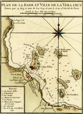 | Details | Bellin, Jacques Nicolas | 1754 |
| Plan de la Rade et Ville de la Veracruz, Mexico. |
|
Bellin, Jacques Nicolas |
|
| 1754 |
| LOC:0 |
| $0.00 | Bellin--Jacques-Nicolas | Plan-de-la-Rade-et-Ville-de-la-Veracruz--Mexico- | SOLD<br></br>One of the earliest available port plans of Veracruz, Mexico, the harbor of Veracruz and nearby islands. Notations of numerous depth soundings, sandbanks (ex: Banc de Roches; le Banc Forain; le Grand Banc de Roches) , and an anchorage attest to the nautical heritage of this small antique French port plan. From the 15-volume "Histoire Generale des Voyages" of Antoine François Prévost published from Paris in 1754. Tome XII. Number 7.
<br></br>
It was on the island of San Juan de Ulúa that Spanish captain Juan de Grijalva first arrived in 1518, along with conquistador and author Bernal Díaz del Castillo ("The True History of the Conquest of New Spain"). That island was also the scene of a battle in 1569 between the Spanish Navy and a fleet led by John Hawkins that included Francis Drake. The treachery that the English perceived on the part of Spain at that battle helped to fuel antagonism between the two powers for many decades.
<br></br>
In Veracruz several key points are identified on a legend at bottom right including:
<div class="indenttextblock">
<ul style="list-style-type: circle;">
<li>La Grande Eglise</li>
<li>L 'Inquisition</li>
<li>Les Jesuits</li>
<li>Maison de Gouverneur </li>
<li>La Douane (the customs house)</li>
<li>Maison de Compagnie de l'Assiente</li>
<li>Les Augustins</li>
</ul>
</div> |
| 5213 | 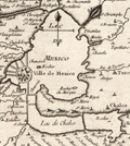 | Details | Bellin, Jacques Nicolas | 1754 |
| Antique plan of Mexico City with Lake Texcoco Cortez Moctezuma |
|
Bellin, Jacques Nicolas |
|
| 1754 |
| LOC:77 |
| $250.00 | Bellin--Jacques-Nicolas | Antique-plan-of-Mexico-City-with-Lake-Texcoco-Cortez-Moctezuma | Original engraved French map of the Valley of Mexico and Mexico City as it was when encountered by Spanish conquistador Hernán Cortés in 1521. Shows Mexico City or Tenochtitlán, the island capital of the Aztec state. In this copper-plate engraved image Tenochtitlán is located near the southwest end of the "Lac de Mexico" or Lake Texcoco. Tenochtitlán was connected to the Valley of Mexico via several causeways. Includes the larger cities of Pachuca, Tezcuco, Chalco. Tenochtitlan was largely destroyed by Cortés after a siege in 1521, and modern-day Mexico City now lies over much of its remains.
<br></br>
By Jacques Bellin. Published in a French edition of L'Abbe Prevost's "Histoire Générale des Voyages". Tome 2 No. 5. |
| 1402 | 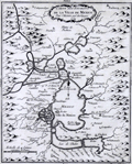 | Details | Bellin, Jacques Nicolas | 1754 |
| Antique Pre-Columbian Plan of Mexico City |
|
Bellin, Jacques Nicolas |
|
| 1754 |
| LOC: |
| $300.00 | Bellin--Jacques-Nicolas | Antique-Pre-Columbian-Plan-of-Mexico-City | Early French map of the Valley of Mexico and Mexico City. Shows Mexico City or Tenochtitlán, the island capital of the Aztec state, as it was when encountered by Spanish conquistador Hernán Cortés in 1521. In the copper-plate engraved image Tenochtitlán is located near the southwest end of the "Lac de Mexico" or Lake Texcoco. Tenochtitlán was connected to the Valley of Mexico via several causeways. Includes the larger cities of Pachuca, Tezcuco, Chalco. No mention of Teotihuacan. By French cartographer Nicolas Bellin.
<br></br>
Framed and matted meaures 12" W x 14" H.
<br></br>
Tenochtitlan was largely destroyed by Cortés after a siege in 1521, and modern-day Mexico City now lies over much of its remains.
<br></br>
Published in a French edition of L'Abbe Prevost's "Histoire Générale des Voyages". Tome 12, No. 10. |
| 1403 | 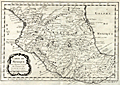 | Details | Bellin, Jacques Nicolas | 1754 |
| Antique Map of Central Mexico |
|
Bellin, Jacques Nicolas |
|
| 1754 |
| LOC:0 |
| $0.00 | Bellin--Jacques-Nicolas | Antique-Map-of-Central-Mexico | Not available
<BR></BR>
Original mid 18th-century French map of the Central Mexico region. This early cartographic artifact covers an area from roughly south of Durango to a line north of Acapulco. In all, a fine copperplate-engraved antique map of Mexico by N. Bellin that includes the towns of "Mazatland" (Mazatlan), "Guadalaxara" (Guadalajara), Zacatecas, Veracruz, "Mechoacan", and many more. Shows mountains in relief, many rivers, and small villages. Dated within an elaborate cartouche to 1754.
<br></br>
Framed, glazed, and double matted. Size with frame 18.5" x 15".
<br></br>
Published in a French edition of L'Abbe Prevost's "Histoire Générale des Voyages". Tome 12, No. 8. |
| 3659 | 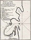 | Details | Bellin, Jacques Nicolas | 1754 |
| Antique port plan of Acapulco, Mexico |
|
Bellin, Jacques Nicolas |
|
| 1754 |
| LOC:77 |
| $185.00 | Bellin--Jacques-Nicolas | Antique-port-plan-of-Acapulco--Mexico | J.N. Bellin's neat antique plan of the walled fort, port and harbor at Acapulco, Mexico. Includes a French-language key to fourteen principal locations on the plan including Fort San Diego with 100 pieces of cannon, four new bastions lining the bay, and on the south side of the bay- two trees where the Manilla Galleon attaches a cable (rope) for mooring.
<br></br>
North is oriented to the left. Page 195. |
| 263 |  | Details | Jefferys, Thomas | 1762 |
| Plan of la Vera Cruz from Spanish Draughts. |
|
Jefferys, Thomas |
|
| 1762 |
| LOC:5 |
| $425.00 | Jefferys--Thomas | Plan-of-la-Vera-Cruz-from-Spanish-Draughts- | Antique copperplate engraved map / port plan of the fortified city of 'la Vera Cruz' and historically significant Fort San Juan de Ulúa in the Mexican state of Veracruz. Published in 1762 by the prolific British engraver and publisher Thomas Jefferys (ca.1710-1771) in "A Description of the Spanish Islands and Settlements on the Coast of the West Indies, compiled from Authentic Memoirs, Revised by Gentlemen who have Resided Many Years in the Spanish Settlements".<br></br>
It was on the island of San Juan de Ulúa that Spanish captain Juan de Grijalva first arrived in 1518, along with conquistador and author Bernal Díaz del Castillo ("The True History of the Conquest of New Spain"). That island was also the scene of a battle in 1569 between the Spanish Navy and a fleet led by John Hawkins that included Francis Drake. The treachery that the English perceived on the part of Spain at that battle helped to fuel antagonism between the two powers for many decades. <br></br>
In Vera Cruz several key points are identified including the powder magazine, a 'magazine of masts for the galleons', and numerous churches, chapels, and sites associated with religious orders of Jesuits, Dominicans, Augustines, and Franciscans.<br></br>
Plate 14. Page 64. Contains an 11 item legend. |
| 669 | 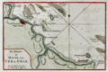 | Details | Tirion, Isaac | 1769 |
| Veracruz, Mexico |
|
Tirion, Isaac |
|
| 1769 |
| LOC:5 |
| $165.00 | Tirion--Isaac | Veracruz--Mexico | <br></br>Original antique chart of Veracruz, Mexico. Prominently features the walled city of Vera Cruz with the fortress (Kafteel) of San Juan de Ulua across a narrow channel. Includes Green Island ( Groen Eiland ) , White Island, Offerhanden Island, Blanquilla Island, Rivier Medello, Cape Gorda, Cape Hornos, Cape Mocamba, and Cape d'Anton Lizardo. Hydrographic features include numerous soundings and sandbanks.
<br></br>
It was on the island of San Juan de Ulúa that Spanish captain Juan de Grijalva first arrived in 1518, along with conquistador and author Bernal Díaz del Castillo ("The True History of the Conquest of New Spain"). That island was also the scene of a battle in 1569 between the Spanish Navy and a fleet led by John Hawkins that included Francis Drake. The treachery that the English perceived on the part of Spain at that battle helped to fuel antagonism between the two powers for many decades.
<br></br>
Published in 1769 from Amsterdam by Isaac Tirion (1705 - 1765) in his "Hedendaagsche Historie of Tegenwoordige Staat van Amerika" or "Modern History". |
| 895 | 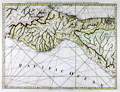 | Details | Jefferys, Thomas | 1775 |
| Antique Chart of Southern Mexico from Veracruz to Ciudad del Carmen |
|
Jefferys, Thomas |
|
| 1775 |
| LOC:51 |
| $920.00 | Jefferys--Thomas | Antique-Chart-of-Southern-Mexico-from-Veracruz-to-Ciudad-del-Carmen | Beautiful antique British chart of southern Mexico and Guatemala centered on the Mexican state of Oaxaca. This first edition chart by Thomas Jefferies in 1775, includes coastal features of the <b>Bay of Campeche</b> to the north and the <b>Gulf of Tehuantepec</b> on the Pacific or southern coast. This chart contains significant interior details including volcanos (e.g. Vulcan de San Martin or "el Pan de Mizapa"), rivers, mountains, and numerous towns and villages.
<br></br>
First, more scarce edition with spelling error in the title: "NEUva Veracruz". In the second edition the title was corrected to "NUEva Vera Cruz".
<br></br>
On the northern Gulf Coast in Mexico's Veracruz and Tabasco states significant habitations include <b>Nueva Vera Cruz</b>, San Juan de Ulua, a fort, guardhouse, and dock near the Laguna de Alvarado ("Rio Alvarado"), smaller villages both near the mouth of the Rio Grijalva and Frontera, and in the vicinity of Ciudad del Carmen ("Y. Triste"). Fascinating note south of the Laguna de Terminos at far right corner reads "<b>Logwood Creeks</b> occupied formerly by the English". Logwood, a small tree used to produce dye for clothing, was one of the main exports from the region. Notably, in 1675, the explorer and sometime buccaneer William Dampier traveled to "Campeachy" and worked among the logwood-cutters.
<br></br>
On the Pacific Coast, in the states of Oaxaca and Chiapas noted villages include: Puerto Angel ("Puerto de Angeles"), Puerto Escondido, Galera ("Punta de la Galera"), Tangolunda ("Tangolo or Tangolotanga"), "Puerta de la Ventosa", Salina Cruz, and Puerto San Jose, Guatemala ("Port of Guatimala").
<br></br>
Publishers attribution reads: "London. Printed for Rob.t Sayer, Map and Printseller. No 53 Fleet Street as the Act directs 20th Feb.y 1775. Online sources indicate that the misspelling of Nueva as "Neuva" is a characteristic of Jeffery's first state of this chart. |
| 4958 | 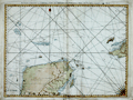 | Details | Jefferys, Thomas | 1775 |
| Jefferys Antique Chart of the Yucatan Peninsula |
|
Jefferys, Thomas |
|
| 1775 |
| LOC:52 |
| $650.00 | Jefferys--Thomas | Jefferys-Antique-Chart-of-the-Yucatan-Peninsula | Well-worn, decorative antique sea chart covering from the Yucatan Peninsula of Mexico to western Cuba, including Merida, Valladolid, Loggerhead Key, Cozumel, Isla Mujeres, etc. By English cartographer Thomas Jefferys. A fleet of galleons is shown on a plotted track labeled: "Gallions Track from Cartagena", while two ships head west along a plotted track labeled: "Track from Cape Catoche to Campeche." To round out the cast of characters a third ship, apparently a privateer, exits a shorter track between two rocky areas. That track is noted as the "Passage del Corsario" (A corsair was a privateer, or pirate acting with the explicit backing of a foreign government).
<br></br>
From Sayer's and Bennett's atlas titled: The West-India Atlas: or, a compendious description of the West-Indies: illustrated with forty one correct charts and maps, taken from actual surveys."
<br></br>
Publishers attribution reads: "London. Printed for Rob.t Sayer, Map and Print seller. No 53 Fleet Street as the Act directs 20th Feb.y 1775. |
| 4807 | 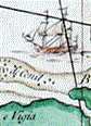 | Details | Jefferys, Thomas | 1775 |
| Jefferys excellent 1775 antique chart of the Yucatan Peninsula to western Cuba |
|
Jefferys, Thomas |
|
| 1775 |
| LOC:0 |
| $1,050.00 | Jefferys--Thomas | Jefferys-excellent-1775-antique-chart-of-the-Yucatan-Peninsula-to-western-Cuba | Antique engraved sea chart from <b>Yucatan</b> Peninsula to western Cuba. Numerous large square-rigged ships are depicted enroute to either Campeche; Cartagena, Colombia; or Havana, Cuba.
<br></br>
Published under Thomas Jeffery's name by Sayer and Bennet. Includes <b>Merida, Valladolid, Loggerhead Key, Cozumel, Isla Mujeres</b>, etc.
<br></br>
This 1775 original British privately-published chart is a continuation of Jefferys' magnificent map of Cuba, which omits the western tip of the Pearl of the Antilles, Cuba.
<br></br>
A fleet of square-rigged galleons is shown sailing on a plotted track labeled: "Gallions Track from Cartagena", while two ships sail west along a plotted track labeled: "Track from Cape Catoche to Campeche." To round out the cast of characters a third ship, apparently a privateer, exits a shorter track between two rocky areas. That track is noted as the "Passage del Corsario." Note: a favorite tactic of pirates, corsairs, and cocaine smugglers has long been to use local knowledge of the water depth and hazards to frustrate pursuers.
<br></br>
From Sayer's and Bennett's atlas titled: The West-India Atlas: or, a compendious description of the West-Indies: illustrated with forty one correct charts and maps, taken from actual surveys."
<br></br>
Publishers attribution reads: "London. Printed for Rob.t Sayer, Map and Print seller. No 53 Fleet Street as the Act directs 20th Feb.y 1775. According to Rumsey <div class="indenttextblock">
"Sayer and Bennet acquired his [Jefferys'] materials in preparation for this atlas, and published the atlas posthumously under his name (as they did with the American Atlas) in 1775. The heart of this atlas and the most detailed part is the sixteen sheet large chart and index sheet of the whole of the West Indies. (
<a href="http://www.davidrumsey.com/luna/servlet/detail/RUMSEY~8~1~2795~310044:The-coast-of-Yucatan-from-Campeche-" target="_blank">Internet </a>)
</div> |
| 1078 | 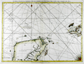 | Details | Jefferys, Thomas | 1775 |
| Antique Chart of the Yucatan Peninsula and Western Cuba |
|
Jefferys, Thomas |
|
| 1775 |
| LOC:0 |
| $0.00 | Jefferys--Thomas | Antique-Chart-of-the-Yucatan-Peninsula-and-Western-Cuba | SOLD<br></br>See another example of
<a href="https://www.rarecharts.com/ShowDetail/Creator/Jefferys--Thomas/Title/Jefferys-excellent-1775-antique-chart-of-the-Yucatan-Peninsula-to-western-Cuba/4807" target="_blank">
Jeffery's chart</a> for sale from our collection. |
| 118 | 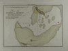 | Details | Direccion Hidrografia | 1809 |
| Plano del Puerto del Alacran |
|
Direccion Hidrografia |
|
| 1809 |
| LOC:5 |
| $400.00 | Direccion-Hidrografia | Plano-del-Puerto-del-Alacran | Small, extremely rare, antique copperplate island chart from the Direccion Hidrografia, Spain's equivalent of the Depot de la Marine in France. This chart is one of 66 charts from the second volume of the work published in 1809: "Portulano de la America Setentrional Construido en la Direccion Detrabajos Hidrograficos. Antique Spanish sea charts of their New World possessions from this time period are not often found.<BR> </BR>
About 65 miles from the Yucatan coast of Mexico the Alacranes (Scorpion) reef was declared a Marine Protection Area in 1994. The chart includes numerous soundings along with the composition of the sands near the reef. Shows 4 small islands: Isla de Perez, La Lavendera, Isla Chica, and Isla de Pajaras. North oriented at the right of the chart. |
| 406 |  | Details | Humboldt, Alexander von | 1811 |
| Plan du Port de Veracruz |
|
Humboldt, Alexander von |
|
| 1811 |
| LOC:0 |
| $0.00 | Humboldt--Alexander-von | Plan-du-Port-de-Veracruz | <BR> </BR>
SOLD
<BR> </BR>
Chart and plan of the walled city of Veracruz, Mexico and surrounding area by scientist and explorer Alexander von Humboldt after a chart by Spain's Deposito Hidrograficos. Important features include: Isla de Sacrificios; Chateau de St. Juan de Ulua; the Cathedral; Chapelle du Santo Christo et Cimetiere, and several suggested courses for ships entering the harbor. Delicate, fine stippled engraving and numerous soundings. Inset profile view at upper left from Villa Rica to Punta Delgada. An excellent example.<BR> </BR>
From: "Atlas Géographique Et Physique Du Royaume De La Nouvelle-Espagne, Fonde Sur Des Observations Astronomiques, Des Mesures Trigonometriques Et Des Nivellemens Barometriques." Par Al. De Humboldt. Paris, Chez F. Schoell, Rue Des Fosses-Saint-Germain -L'Auxerrois, No. 29. 1811. De L'Imprimerie De J.H. Stone.<BR> </BR> |
| 1300 | 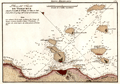 | Details | Direccion Hidrografia | 1818 |
| Antique Spanish chart the port of Veracruz, Mexico. |
|
Direccion Hidrografia |
|
| 1818 |
| LOC:10 |
| $850.00 | Direccion-Hidrografia | Antique-Spanish-chart-the-port-of-Veracruz--Mexico- | A scarce Spanish nautical chart of the harbor, islands, and waters surrounding Veracruz, Mexico. An original antique navigation chart by the Direccion Hidrografia; the detailed chart is dotted with numerous depth soundings and notation of composition of the sea floor, e.g. arena (sand), piedra (rock), and lama (mud).
<br></br>
Place names and features on this old Spanish harbor chart include Castillo de San Juan de Ulua, Arrecife e Isla de Pajaros, Arrecife de la Blanquilla, Punta de la Gallega, Punta de Hornos, and Arrecife de Punta Gorda and Arrecife e Isla de Sacrificios. Isla de Sacrificios has a bloody past. Bernal Diaz del Castillo reports that when the Spanish first landed on the Isla de Sacrificios:
<div class="indenttextblock">
"We found two stone buildings of good workmanship, each with a flight of steps leading up to a kind of altar, and on those altars were evil-looking idols, which were their gods. Here we found five Indians who had been sacrificed to them on that very night. Their chests had been struck open and their arms and thighs cut off, and the walls of these buildings were covered in blood. All this amazed us greatly, and we called this island the Isla de Sacrificios, as it is now named on the charts."
</div>
<BR/>
From the second part of "Portolano de la America...", published in 1818 by Spain's Admiralty department, the Dirección de Hidrografía. In 1809 the Direccion first published this atlas of plans of bays, harbors, and ports from Spain’s New World possessions: "Portolano de la America Septentrional Construido en la Direccion de Trabajos Hidrograficos". (Updated in 1818). Plate 52. |
| 5406 | 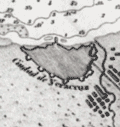 | Details | Direccion Hidrografia | 1818 |
| Plano del Puerto de Veracruz situado el Castillo de San Juan de Ulua Mexico |
|
Direccion Hidrografia |
|
| 1818 |
| LOC: |
| $375.00 | Direccion-Hidrografia | Plano-del-Puerto-de-Veracruz-situado-el-Castillo-de-San-Juan-de-Ulua-Mexico | Fine, original, engraved Spanish nautical chart of the harbor, islands, and waters surrounding Veracruz, Mexico by the Direccion Hidrografia [1]. The detailed chart is dotted with numerous depth soundings and notation of composition of the sea floor, e.g. arena (sand), piedra (rock), and lama (mud).
<br></br>
Place names and features on this old Spanish harbor chart include [2]:
<div class="indenttextblocksingle">
<ul style="list-style-type: circle;">
<li>Castillo de San Juan de Ulua</li>
<li>Arrecife e Isla de Pajaros</li>
<li>Arrecife de la Blanquilla</li>
<li>Punta de la Gallega</li>
<li>Punta de Hornos</li>
<li>Arrecife de Punta Gorda</li>
<li>Arrecife e Isla de Sacrificios</li>
<li>Anegada de adentro</li>
<li>Arrecife de Isla Verde</li>
</ul>
</div>
[1] From the second part of "Portolano de la America...", published in 1818 by Spain's Admiralty department, the Dirección de Hidrografía. In 1809 the Direccion first published this atlas of plans of bays, harbors, and ports from Spain’s New World possessions: "Portolano de la America Septentrional Construido en la Direccion de Trabajos Hidrograficos". Plate 52.<br/>
[2] Arrecife = reef; Isla = island; Anegada = flooded or underwater. |
| 3603 | 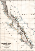 | Details | Perthes, Justus | 1868 |
| Map of Baja California |
|
Perthes, Justus |
|
| 1868 |
| LOC:0 |
| $0.00 | Perthes--Justus | Map-of-Baja-California | SOLD
<br></br>
Original geographical, German map of Baja California in 1868 for the Lower California Company with information taken from the expeditions of J. Ross Browne. In 1866 the Lower California Company purchased the Baja Peninsula from 24 degrees 20'
to 31 degrees including both coasts of the peninsula. The company's intent was to colonize and exploit the lands.
<br></br>
From "Mittheilungen aus Justus Perthes' Geographischer Anstalt uber Wichtige Neue Erforschungen auf dem Gessammtgebiete der Geographie von Dr. A. Petermann, 1868." Roughly: "Communications from Justus Perthes Geographical Institute Concerning Important New Studies in the Whole Field of Geography by Dr. Augustus Petermann, 1868. Drawn by C. Hellfarthin.
<br></br>
Finely printed by Justus Perthes in blues and greys.
<br></br> |
| 4926 | 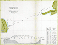 | Details | U.S. Coast and Geodetic Survey | 1872 |
| Antique chart of the Yucatan Channel Mexico Cuba |
|
U.S. Coast and Geodetic Survey |
|
| 1872 |
| LOC:13 |
| $240.00 | U-S--Coast-and-Geodetic-Survey | Antique-chart-of-the-Yucatan-Channel-Mexico-Cuba | Scarce U.S. Coast and Geodetic Survey hydrographic chart of the Yucatan Channel with soundings from 1872 taken by R. Platt then an Acting Master in the U.S.N.
<br /><br />
Old survey chart of the channel between the east Yucatan area of Mexico and the Cape San Antonio Light in Cuba. Inset drawing of the profile of the channel with a horizontal scale of 1 / 100,000. With a tabular display of the type of bottom composition (sand, mud …) encountered by depth of the soundings. |
| 4790 | 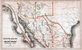 | Details | Bancroft, Hubert Howe | 1883 |
| Native races of the Pacific states New Mexican group |
|
Bancroft, Hubert Howe |
|
| 1883 |
| LOC:77 |
| $70.00 | Bancroft--Hubert-Howe | Native-races-of-the-Pacific-states-New-Mexican-group | Shows the names and lands of the Native American Indians. Covers the full extent of the Baja California peninsula, the Sea of Cortez, parts of Texas, Mexico, Arizona and New Mexico. Places Cape (Cabo) San Lucas at the tip of the Baja peninsula. Native tribes placed in their geographical context include the Guanicuris, Cochimis, Yuma, Papago, Comanche, Zuni, Navajo and many more.
<br></br>
From Bancroft's "The Native Races of the Pacific States of North America." Includes land formations, political boundaries, and rivers. |
| 5150 | 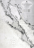 | Details | British Admiralty Hydrographical Office | 1925 |
| Antique Chart of Baja California and Sea of Cortez |
|
British Admiralty Hydrographical Office |
|
| 1925 |
| LOC:63 |
| $0.00 | British-Admiralty-Hydrographical-Office | Antique-Chart-of-Baja-California-and-Sea-of-Cortez | SOLD<br><br>This authentic British nautical chart includes the states of Baja California, Baja California Sur, Sonora, Mexico and the Sea of Cortez. This large chart will make a very attractive, unusual, and affordable gift for anyone with an interest in fishing or boating in the vicinity of Baja California. Numerous well-known fishing spots are noted including: San Jaime Bank, Golden Gate Bank, Outer Gorda Bank, Finger Bank, and Morgan Bank. Two inset profiles of Cabo San Lucas. Engraved by Davies and Company.
<br></br>
This is a later edition of a British Admiralty chart first engraved and published from London in 1879, and updated numerous times after that. Last corrections from 1925.
<br></br>
Coverage includes the entire Baja Peninsula and Gulf of California (Sea of Cortez) from San Diego, California to Cabo San Lucas, Mexico. Contains detailed names of the numerous rivers, lights, capes, and bays surrounding the Baja Peninsula. For example: Todos Santos Bay, Rosario Bay, Boca de Santo Domingo, Port San Bartolome, Cape San Lazaro, Santa Margarita Island, Lusitania Bank, Magdalena Bay, Pescadero Point, San Jose del Cabo Bay, Ceralbo Island, and San Jose Island.
<br></br>
This bold dark lithographed chart retains the cartographic look and style of the late 19th century. Logo of the British Hydrographical Office at top of the title block. Published from London on April 9, 1879 (1925). Number 2324 |
| 1338 | 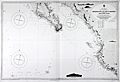 | Details | British Admiralty Hydrographical Office | 1926 |
| Chart of Lower Baja California, Cabo San Lucas, to Manzanilla Bay |
|
British Admiralty Hydrographical Office |
|
| 1926 |
| LOC:0 |
| $525.00 | British-Admiralty-Hydrographical-Office | Chart-of-Lower-Baja-California--Cabo-San-Lucas--to-Manzanilla-Bay | Amazing, clean, authentic British nautical chart of lower Baja Peninsula and west coastal Mexico with Sinaloa, Jalisco and the Sea of Cortez. Heading southward this popular and highly attractive chart covers from San Ignaciao Bay to Manzanillo Bay. This large chart will make a very attractive, unusual, and affordable gift for anyone with an interest in fishing or boating in the vicinity of Baja California. Thousands of depth soundings and numerous well-known fishing spots are noted including: San Jaime Bank, Golden Gate Bank, Outer Gorda Bank, Finger Bank, and Morgan Bank. Two inset profile views at top of the Baja Californa coast as seen from offshore near Las Animas.
<br></br>
Later edition of a British Admiralty chart first engraved and published from London in 1879; this edition to 1916 and the last corrections made in 1926. Coverage includes the lower Baja California Peninsula and Gulf of California (Sea of Cortez) from Las Animas to Cabo San Lucas, Mexico, Mazatlan, Cape Corrientes, and on to Manzanillo Bay. Contains detailed names of the numerous rivers, lights, capes, and bays surrounding the Baja Peninsula. Includes the Revillagigedo Archipelago.
<br></br>
Bold dark lithographed print retains the cartographic look and style of the late 19th century. More recent charts do not display the character of this beauty. Logo of the British Hydrographical Office at top of the title block. Originally published from London on April 9, 1879 but the edition of 1916 with corrections to 1926. Number 2323. |
| 1075 | 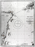 | Details | British Admiralty Hydrographical Office | 1927 |
| Chart of the eastern Yucatan Peninsula with Cozumel and Tulum |
|
British Admiralty Hydrographical Office |
|
| 1927 |
| LOC:0 |
| $0.00 | British-Admiralty-Hydrographical-Office | Chart-of-the-eastern-Yucatan-Peninsula-with-Cozumel-and-Tulum | SOLD<br></br>Very cool antique British chart of the east side of Mexico's Yucatan Peninsula with the Yucatan Channel and the west end of Cuba. Produced decades before the building boom of the 1970s and beyond. Several areas offshore carry the printed note: "Good Fishing" . Key features include: Cozumel Island, Tulum, Isla Blancilla, Yalahau Fort, Cabo Catoche, Puerto de Mujeres, Bahia de la Ascension, Arrowsmith Bank, Bahia del Espititu Santo, Banco Chinchorro, Turneffe, Lighthouse Reef, and Swan Island.
<br></br>
Lighthouses and aids to navigation are highlighed in orange. Steel engraved nautical chart with the oval logo of the "Hydrographic Office" at bottom right.
<br></br>
Frequent updates noted at bottom left. Large corrections to 1915. Small corrections to 1925 with an additional hand written correction to 1927. Sold by J. D. Potter, Agent for the Sale of the Admiralty Charts. Chart number 1204. Price when issued was two shillings. |
| 6801 | 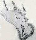 | Details | British Admiralty Hydrographical Office | 1933 |
| Original Nautical Chart Baja Cabo San Lucas |
|
British Admiralty Hydrographical Office |
|
| 1933 |
| LOC: |
| $0.00 | British-Admiralty-Hydrographical-Office | Original-Nautical-Chart-Baja-Cabo-San-Lucas | SOLD
<br><br>
Fine British Admiralty nautical chart of lower or Baja California published by the Admiralty on July 25, 1903 (last correction in 1933). Shows the Baja California Peninsula south of Ameljas Bay (24 degrees 38 minutes N latitude). The southernmost 15 miles of the Baja Peninsula with Cape Falso, San Lucas Bay, and Cabo San Lucas are shown in an inset or "compartment" at bottom right. Chart number 3327.
<br><br>
Numerous soundings in fathoms. Fine topographic detail for the coastal interior of the peninsula. |
| 6530 | 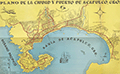 | Details | Anonymous | 1950 |
| Scarce plan of the city of Acapulco, Mexico |
|
Anonymous |
|
| 1950 |
| LOC:86 |
| $0.00 | Anonymous | Scarce-plan-of-the-city-of-Acapulco--Mexico | SOLD
<br><br>
Very unusual and scarce folding map or plan of Acapulco, Mexico on the Pacific Ocean ca. 1950: "Plano de la Ciudad y Puerto de Acapulco". A street plan of Acapulco in the mid-20th century with images of fish, Spanish galleons, and a twin-engine propellor-driven aircraft. Legend at bottom left identifies, government offices, hotels, schools, churches and local public transportation routes identified with red outline color.
<br><br>
Just below the title is a representation of the shield of the city of Acapulco, symbolizing two hands that break a leafy reed.
<br><br>
Numerous subdivisions (fraccionamientos) are noted in bold black headings including:
<div class="indenttextblocksingle">
<ul style="list-style-type: circle;"></li>
<li>Fraccionamiento Mozimba</li>
<li>Fraccionamiento Vista Allegre</li>
<li>Fraccionamiento Magallanes</li>
<li>Fraccionamiento Deportivo</li>
<li>Fraccionamiento Costa Azul</li>
</ul>
</div> |
| 6834 | 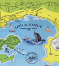 | Details | Melendez, Gilberto | 1955 |
| Fine mid-century pictorial map of Acapulco Mexico |
|
Melendez, Gilberto |
|
| 1955 |
| LOC:86 |
| $395.00 | Melendez--Gilberto | Fine-mid-century-pictorial-map-of-Acapulco-Mexico | Quite attractive touristic pictorial map of Acapulco Bay and surrounding areas. Inset map at top in a larger scale showing the road network between Acapulco and Mexico City. Additional inset map at right of Centro Downtown. Scarce.
<br><br>
Map contains an inset of the main advertiser, Hotel Caleta. Noted features include Isla la Roqueta, Puerto Marquez, el Patal Beach, Playa Suave, and many more. Inset tables identify local nightclubs and beaches. Produced by Gilberto Melendez. |
| 6696 |  | Details | U. S. Navy Oceanographic Office | 1964 |
| United States Navy Chart of Baja California. |
|
U. S. Navy Oceanographic Office |
|
| 1964 |
| LOC:68 |
| $225.00 | U--S--Navy-Oceanographic-Office | United-States-Navy-Chart-of-Baja-California- | Very large original U. S. Navy chart of the Baja Peninsula and the Gulf of California. U.S. and British Admiralty charts of Baja California are among the most requested items on RareCharts.
<br><br>
Dark shading on land areas enhances the contrast between land and sea. Manuscript traces of faded writing.
<br><br>
<div id="0" align="center">
<a title=""></a>
<img id="6648" src="/ZoomifyImages/SC_6696/SC_6696_detail.jpg" alt="Very large original U. S. Navy chart of the Baja Peninsula and the Gulf of California, 1964" width="340"/> <br><br> <font size="-2">Baja- La Paz Bay and Isla Espiritu Santo</font>
</div><br>
"Mexico - West Coast Cabo San Lazaro to Cabo San Lucas and Southern Part of Golfo de California. From U. S. Navy Surveys between 1873 and 1901 with additions in 1962". 1st edition was in 1876 but this 68th edition last revised in June, 1964. Mercator projection. Catalog region 2. Chart # 621. |
| 3606 | 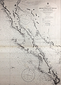 | Details | British Admiralty Hydrographical Office | 1965 |
| Chart of Baja California and Sea of Cortez |
|
British Admiralty Hydrographical Office |
|
| 1965 |
| LOC:0 |
| $0.00 | British-Admiralty-Hydrographical-Office | Chart-of-Baja-California-and-Sea-of-Cortez | SOLD
<br></br>
Later 1965 edition of a British Admiralty chart first engraved and published from London in 1879, and updated numerous times after that. Coverage includes the entire Baja Peninsula and Gulf of California (Sea of Cortez) from San Diego, California to Cabo San Lucas, Mexico.
<br></br>
Bold dark lithographed print retains the cartographic look and style of the late 19th century. Logo of the British Hydrographical Office at top of the title block. Published from London on April 9, 1879, but 1965. Number 2324 |
| 5389 | 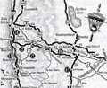 | Details | National Automobile Club | 1969 |
| About Baja California booklet with maps Mexico |
|
National Automobile Club |
|
| 1969 |
| LOC:3 |
| $90.00 | National-Automobile-Club | About-Baja-California-booklet-with-maps-Mexico | Fine original booklet for Baja California by the National Automobile Club, circa 1969, with two road maps of the automobile route from San Diego down Mexico's Baja Peninsula.
<br></br>
12 pages, with an dark green faux-leather, embossed, stapled card cover.
<br></br>
Text describes local accommodations and details each segment of the journey southward with the warning:<br>
<b>Travel South of Rosario By Passenger Automobile Not Recommended Under Any Circumstances."</b> |
| 781 | 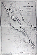 | Details | British Admiralty Hydrographical Office | 1971 |
| Chart of Baja California and the Sea of Cortez |
|
British Admiralty Hydrographical Office |
|
| 1971 |
| LOC:0 |
| $0.00 | British-Admiralty-Hydrographical-Office | Chart-of-Baja-California-and-the-Sea-of-Cortez | SOLD but… we have been able to acquire
<a href="https://www.rarecharts.com/ShowDetail/Creator/British-Admiralty-Hydrographical-Office/Title/Antique-Chart-of-Baja-California-and-Sea-of-Cortez/5150" target="_blank"> an earlier edition of the same chart from 1925 now in stock.
</a>
<br></br>
<hr>
<br></br>
British Admiralty chart first engraved and published from London in 1879, and updated numerous times after that. Coverage includes the entire Baja Peninsula and Gulf of California (Sea of Cortez) from San Diego, California to Cabo San Lucas, Mexico. |
| 697 | 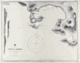 | Details | British Admiralty Hydrographical Office | 1972 |
| Acapulco Harbor |
|
British Admiralty Hydrographical Office |
|
| 1972 |
| LOC:0 |
| $125.00 | British-Admiralty-Hydrographical-Office | Acapulco-Harbor | Neat, attractive, authentic 20th century nautical chart of Acapulco, Mexico by the British Admiralty after an 1881 U.S. chart. This chart has character. Though published by the Admiralty in 1972, this chart retains much of the style and appearance of earlier copper-plate engraved charts but on modern paper in fine condition. Features shown on the map include Fort San Diego, Isla Roqueta or Isla Grifo, Puerto Marques, Punta Rodrigo, Punta Diamante (Diamond Point), Punta Bruja, Bahia St. Lucia, Punta Lorenz, Farallon de Obispo, the Fiscal Wharf and las Dos Piedras. The town of Acapulco is shown as it must have looked when the chart was first published… very small in extent.
<br></br>
This chart was originally published in August 1849 but updated and corrected numerous times, as documented at bottom left of the chart,- including 1882 (re-engraved) and 1945, and this copy dates to 1972. Numerous soundings and aids to navigation are noted.
<br></br>
With two profile view insets: 1) "Acapulco from the Westward, Isla Roqueta, 093° distant 9 or 10 miles" Boca Chica and Puerto Marques and 2) "Acapulco from the S.W., I Roqueta 042° distant 9 or 10 miles" with Punta Diamante. Modern compass rose with half fleur-de-lis indicating North.
Verso is stamped "Printed [19]72 1944 Acapulco Harbor. Folio 25. Consecutive number 11." Chart no. 1944. |
| 6552 |  | Details | British Admiralty Hydrographical Office | 1978 |
| Admiralty Chart Baja California Sea of Cortez with Cabo San Lucas |
|
British Admiralty Hydrographical Office |
|
| 1978 |
| LOC:0 |
| $500.00 | British-Admiralty-Hydrographical-Office | Admiralty-Chart-Baja-California-Sea-of-Cortez-with-Cabo-San-Lucas | Original later issue of a British Admiralty nautical chart first engraved and published in London at the Admiralty on April 9, 1879, under the superintendence of Royal Navy Hydrographer Captain F.J. Evans and updated with corrections. Last corrected in 1978.
<br></br>
Coverage on this fine Admiralty nautical chart includes the entire Baja Peninsula and Gulf of California (Sea of Cortez) from San Diego, California to Cabo San Lucas, Mexico.
<br></br>
Numerous well-known fishing spots are noted including: San Jaime Bank, Golden Gate Bank, Outer Gorda Bank, Finger Bank, and Morgan Bank. Two inset profiles of Cabo San Lucas.
<br></br>
Bold, dark, lithographed print retains the cartographic look and style of the late 19th century. Original engraving was executed by Davies and Company. Logo of the British Hydrographical Office at top of the title block. Chart Number 2324. Crown copyright reserved. |