| | Thumbnail | | Creator | Date | Title / Author / Date / Location | Price | | | Description |
| 8034 | 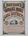 | Details | Mayson, Thomas | 1875 |
| Victorian exhibition advertisement for Mayson’s Relief Ordnance Model |
|
Mayson, Thomas |
|
| 1875 |
| LOC:89 |
| $200.00 | Mayson--Thomas | Victorian-exhibition-advertisement-for-Mayson’s-Relief-Ordnance-Model | Original Victorian exhibition advertisement for Mayson’s 3D Ordnance relief model of the Lake District, Cumbria, North West England, created in 1875 as a major visitor attraction in Keswick. The broadside announces the enormous 210 square foot model exhibited daily at the Lake District Repository on Lake Road, a sculpted landscape built to a scale of six inches to the mile and rendered with exactness from Ordnance Survey data. Bold Victorian lettering, fern motifs, and a vignette of the Repository building frame the promotional text, which highlights mountains, lakes, rivers, waterfalls, villages, and roads shown in full relief and hand colored to nature.
<br><br>
The model was commissioned by Keswick photographer Henry Mayson and his brother Thomas and built by the Italian sculptor Raffaelle Monti and his team using Ordnance Survey sheets as the mathematical basis for every contour. The advertisement stresses its practical value for travelers, noting that the model was an essential tool for planning excursions and understanding the correct topography of the Lake District at a time when tourism was rapidly increasing. Daily opening hours, illumination during summer months, and a one shilling admission charge appear prominently in the lower text block.
<br><br>
As an example of nineteenth century exhibition ephemera, this poster documents one of the most ambitious public relief models ever constructed in Britain and preserves the original marketing for a landmark Lake District attraction. Surviving advertisements for Mayson’s Ordnance Model are scarce, and this sheet stands as a desirable item for collectors of British posters, Lake District history, and early Ordnance Survey derived cartography. |
| 7979 | 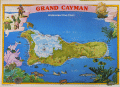 | Details | International Map Services Ltd. | 1975 |
| Grand Cayman Island Underwater Dive Chart |
|
International Map Services Ltd. |
|
| 1975 |
| LOC:86 |
| $175.00 | International-Map-Services-Ltd- | Grand-Cayman-Island-Underwater-Dive-Chart | Unrecorded fine pirate-themed chart of underwater dive sites in the Cayman Island ca. 1975.
Grand Cayman is the largest of the three Cayman Islands, which are a British Overseas Territory in the western Caribbean Sea. The map is specifically an "Underwater Dive Chart," highlighting various dive sites, dive shops and marine life around the island.
<br><br>
Some of the many dive sites noted include: New Tarpon Alley, Hepps Pipeline, Pinnacle Rock, Bonnie's Arch, Oro Verde Wreck, Balboa Wreck, Japanese Gardens, and East End Reefs.
<br><br>
Also noted is Bob Soto's diving shop. Bob Soto (1926–2015), known as the “Father of Diving” in the Cayman Islands, died at age 88, prompting dive flags to fly at half-mast across the islands. He founded recreational scuba diving in the Cayman Islands when he opened the first dive shop on George Town’s waterfront in 1957, starting with one wooden boat, several tanks, and a small staff he personally trained. Soto’s pioneering efforts created the foundation of Cayman’s world-renowned dive industry, mentoring many of today’s dive leaders.
<br><br>
Copyright International Map Services Ltd. P.O. Box 2187. Cayman Islands, B.W.I. "International Map Services Ltd." was a small company based in George Town, Grand Cayman, Cayman Islands, and was involved in the map publishing industry. |
| 7974 | 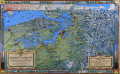 | Details | Kroll Map Company | 1944 |
| Evergreen Playground View of Pacific Northwest First State |
|
Kroll Map Company |
|
| 1944 |
| LOC:130 |
| $250.00 | Kroll-Map-Company | Evergreen-Playground-View-of-Pacific-Northwest-First-State | This pictorial map, titled The Evergreen Playground, (first state with the Tacoma Narrows Bridge lacking a deck) was published in 1944 by the Kroll Map Company of Seattle. It presents a detailed bird’s-eye view of western Washington, extending from Olympia and Tacoma northward through Seattle and Everett to Bellingham and Vancouver, B.C., and eastward to the Cascade Mountains. The map highlights major highways, railways, ferry routes, and points of interest, emphasizing the transportation network and recreational attractions of the Pacific Northwest at mid-century. Drawn by Ed Poland.
<br><br>
Insets along the borders depict regional scenery, industry, and Native American–inspired motifs. The lower right legend identifies the “Unequaled Transportation Facilities” that connect the area by train, highway, and ferry service. The title panel describes the region as unique in North America for combining sea, forest, and mountain environments within a compact area. Printed in full color with topographic shading and decorative borders, this map reflects the Kroll Company’s skill in cartographic illustration and mid-20th-century regional promotion.
<br><br>
Ed (Edwin) Poland was a long-time chief cartographer at the Seattle-based Kroll Map Company, active from at least the 1930s through the postwar era. Poland’s work for Kroll is characterized by dense place-name coverage, promotional vignettes, and clear drafting that made the firm’s Pacific Northwest maps popular for decades. |
| 6813 |  | Details | McMillan, | 1990 |
| Dynamic Clearwater Florida Sailing Poster |
|
McMillan, |
|
| 1990 |
| LOC:55 |
| $95.00 | McMillan- | Dynamic-Clearwater-Florida-Sailing-Poster | Dynamic glossy sailing poster for the 1990 Florida Coastal Management Conference: Navigating the Nineties by McMillan. The 1990 Florida Coastal Management Conference was held in Clearwater, Florida during September 26 - 28.
<br><br>
Could be trimmed and framed. Image alone is ~ 12" x 30". |
| 6738 |  | Details | Soule, George | 1859 |
| Very Rare Antebellum New Orleans advertisement Soule Commercial College |
|
Soule, George |
|
| 1859 |
| LOC:150 |
| $6,500.00 | Soule--George | Very-Rare-Antebellum-New-Orleans-advertisement-Soule-Commercial-College | Very rare New Orleans imprint antebellum broadsheet advertisement or "Balance Sheet Circular" produced by George Soule to advertise Soule's Commercial College, established 1856 at the corner of Camp Street and Common Street, in New Orleans, Louisiana. A finely detailed lithograph featuring exquisite calligraphy, numerous inset views of commercial activities, and four example financial statements, including at bottom right, "Statement of Steamer Eclipse Trip No. 8 T.R. Winn Master."
<br><br>
An online search found only one copy of Soule's "Balance Sheet Circular", at the Historic New Orleans Collection.
<br><br>
<div id="6738" align="center">
<a title=""></a>
<img id="6738" src="/ZoomifyImages/SC_6738/SC_6738_400x300.jpg" alt=" Antebellum advertisement for Soule's Commercial College, established 1856 in New Orleans, LA." width="340"/> <br><br> <font size="-2">Soule's Commercial College Balance Sheet Circular</font>
</div><br>
Lithographed by J. Manouvrier. (2) This fine lithograph with beautiful calligraphy was printed in New Orleans in 1859, just after Soule opened the College at Camp and Common Streets. Between 1856 and 1860 Soule's Commercial College graduated a total of more than 275 students. By 1905 the school could boast 1000 students enrolled, 20 teachers, and over 19,000 former students. The school operated in New Orleans continuously, except for a few years during the Civil War, until 1983 when it finally closed.
<br><br>
<div id="6738_2" align="center">
<a title=""></a>
<img id="6738_2" src="/ZoomifyImages/SC_6738/SC_6738_Detail_2.jpg" alt=" Antebellum advertisement for Soule's Commercial College, a view of Jackson Square." width="340"/> <br><br> <font size="-2">Early View of Jackson Square, New Orleans</font>
</div> |
| 6685 |  | Details | Clarke, Dorothy Linscott | 1964 |
| Pictorial Map New Hampshire Coast |
|
Clarke, Dorothy Linscott |
|
| 1964 |
| LOC:68 |
| $950.00 | Clarke--Dorothy-Linscott | Pictorial-Map-New-Hampshire-Coast | Dorothy Linscott Clarke's desirable lithographed 1964 pictorial map of "New Hampshire's Famous Seacoast Region". Only 1 copy in WorldCat. Rare.
<br><br>
Unlike some artists' pictorial maps, Clarke doesn't attempt cheap humor or resort to demeaning stereotypes in her pictograms. The visual theme throughout could be described as old-fashioned Yankee Nautical as Clarke combines selected history and geography with nautical imagery to produce a map that reflects the nautical past and present of New Hampshire's Coast. Nautical symbols Clarke used include:
<div class="indenttextblocksingle">
<ul style="list-style-type: circle;">
<li>Anchor: The anchor is a symbol of stability, security, and hope. It represents the idea of being grounded and rooted, and being able to weather storms and challenges.</li>
<li>Ships wheel: The ship's wheel, also known as the helm, is a symbol of leadership, guidance, and control. It represents the idea of being able to steer a course through difficult waters.
<li>Whale: The whale is a symbol of strength, power, and the natural world. In maritime culture, whales were often seen as formidable creatures that commanded respect and awe.
<li>Sailor: The sailor is a symbol of adventure, courage, and freedom. Sailors were often seen as brave and resourceful individuals who were willing to venture out and face danger and uncertainty.</li>
<li>Rope: A rope can be seen as a symbol of connection, safety, or security, as it is often used to tie ships to docks or to other vessels.</li>
</ul>
</div>
Other pictorial maps by Dorothy Clarke include:
<div class="indenttextblocksingle">
<ul style="list-style-type: circle;">
<li>A map of Mother-Goose Land. 1933.</li>
<li>A map showing the locations of some of the houses at Strawberry Banke restoration at Portsmouth, N.H. 1965.</li>
<li>Historical picture map of Vermont, "The Green Mountain State." 1939.</li>
<li>A picture map of Noah's Ark for children. Circa 1930.</li>
</ul>
</div> |
| 6678 |  | Details | U.S. Coast Guard | 1972 |
| Coast Guard Poster worldwide locations |
|
U.S. Coast Guard |
|
| 1972 |
| LOC:86 |
| $145.00 | U-S--Coast-Guard | Coast-Guard-Poster-worldwide-locations | Decorative old-stock promotional poster ca. 1973 (1) with the locations of the U.S. Coast Guard around the world, or at least the western world. Executed with elements of 70's style reflecting the influence of the counter-culture on the arts during that period. With the Coast Guard motto : Semper Paratus or Always Ready.
The map omits any locations in Asia, where during that time period there was a war raging in Vietnam. Reminding the viewer of that overseas duty station was probably not conducive to the CG recruiting effort in '73.
<br><br>
Legend at bottom lists the activities and programs the U.S. Coast Guard engaged in including:
<div class="indenttextblocksingle">
<ul style="list-style-type: circle;">
<li>Icebreaking</li>
<li>Iceberg Patrol</li>
<li>Fisheries Conservation</li>
<li>Radio Navigation</li>
<li>Port Safety Vessel Traffic System</li>
<li>Search and Rescue</li>
<li>Aids to Navigation</li>
<li>Law Enforcement</li>
</ul>
</div>
(1) We have dated the map with reference to the planned Omega Station shown on the continent of Australia. Planning for that station was underway as early as 1972 when the Australian Department of Shipping and Transport was making a final site selection decision. The Omega Navigation System was a global radio navigation system that operated from 1971 to 1997. It consisted of eight ground-based stations, including three in Alaska, that transmitted signals in the VLF (Very Low Frequency) range to provide accurate navigation information for ships and aircraft. The Omega Navigation System was eventually replaced by more modern and precise satellite-based navigation systems such as GPS (Global Positioning System)
<br><br>
Document ID: G-PMR30 |
| 6621 | 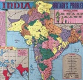 | Details | Sundberg, Edwin L. | 1946 |
| India Britains Problem Child Pictorial Coloroto map |
|
Sundberg, Edwin L. |
|
| 1946 |
| LOC:300 |
| $250.00 | Sundberg--Edwin-L- | India-Britains-Problem-Child-Pictorial-Coloroto-map | Post-WWII pictorial Coloroto (1) or color rotogravure map with India referred to a "Britain's Problem Child", reflecting Britain's colonial presence in India in July, 1946. A legend lists numerous exported products with icons for each including jute, coconut, manganese, copper, linseed, and rubber. Inset map at left shows trade routes from Britain to India via the Suez Canal with British colonies colored in red. Inset pictorial bar chart at right shows the comparative population for each religion in India.
<br><br>
(1) Coloroto is a trade name for a rotogravure used to print multiple colors. According to Google a rotogravure printing system uses a rotary press with <b>intaglio cylinders</b>, typically running at high speed and used for long print runs of magazines and stamps. (Google Oxford languages dictionary. Online).
<br><br> |
| 6613 | 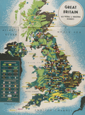 | Details | British Information Services | 1942 |
| Pictorial WWII era propaganda map Great Britain Natural and Industrial Resources |
|
British Information Services |
|
| 1942 |
| LOC:400 |
| $2,500.00 | British-Information-Services | Pictorial-WWII-era-propaganda-map-Great-Britain-Natural-and-Industrial-Resources | Large, lithographed poster-sized map: "Great Britain Her Natural & Industrial Resources" published circa 1942, during WWII, by British Information Services. On the verso a printed statement: "Printed in Great Britain." Scarce on the market and quite nicely executed.
<br><br>
At bottom right the attribution reads: "Distributed by British Information Services, an agency of the British Government, 30 Rockefeller Plaza, New York City." British Information Services was formed in 1941 as an office of the British Government with the goal to promote Britain's interests in the United States. Prior to December 1941 the United States had not formally entered into the war in Europe and this map poster was part of the propaganda Britain employed to sway U.S. opinion to its side. |
| 6605 |  | Details | Black Star Liberation Press | 1974 |
| Astrology and Black People Zodiacal Chart |
|
Black Star Liberation Press |
|
| 1974 |
| LOC:89 |
| $695.00 | Black-Star-Liberation-Press | Astrology-and-Black-People-Zodiacal-Chart | Unrecorded, a bit strange and highly unusual astrological or horoscope poster: "Astrology and Black People" an apparently self-published poster from Berkeley, California in 1974.
<div><img src="/ZoomifyImages/SC_6605/SC_6605_detail.jpg" alt="Title cartouche details for 1974 Astrology and Black People zodiacal chart published by Black Star Liberation Press" width="300" align="center" style="margin: 20px 20px 20px"/>
</div>
The creator's faces, names, astrological sign, and role appear at bottom center in a far-out UFO-style title cartouche: Reggie, layout; Gypsie, astrologer; Detroit, artist; Wayne, details; and Jason, ideas. Black Studies interest.
<br><br>
Published and copyrighted 1974 by Black Star Liberation Press, P.O. Box 3215 Berkeley, California. Verso is blank. |
| 6581 | 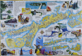 | Details | Mickey, William | 2000 |
| Pictorial map of Marathon and the middle Florida Keys 1st |
|
Mickey, William |
|
| 2000 |
| LOC:130 |
| $250.00 | Mickey--William | Pictorial-map-of-Marathon-and-the-middle-Florida-Keys-1st | Beautifully illustrated and scarce first edition pictorial folding map of the middle Florida Keys including Marathon Key circa 2000. First edition published by William Mickey Art and Design. Map is annotated with names of local businesses.
<br></br>
This original pictorial Map and Guide of Marathon and the Middle Keys is a richly detailed illustrated map of the Florida Keys, centered on Marathon and extending east and west across the Middle Keys. Designed as both a street and harbor guide and a visual souvenir, it presents canals, marinas, bridges, neighborhoods, and waterways alongside bold hand drawn artwork. The combination of practical cartography and colorful illustration makes this map immediately appealing to collectors of Florida Keys maps, Marathon memorabilia, nautical charts, and vintage Florida travel ephemera.<br><br>
The map also serves as an illustrated historical overview of Marathon and its development. Text panels and imagery reference the Calusa Indians, Bahamian fishermen, the arrival of the Overseas Railroad, and the role of Henry Flagler in shaping the Keys as a connected island chain. Historic portraits, early transportation scenes, and descriptive notes provide context for how Marathon evolved from a railroad outpost into one of the largest and most important communities in the Middle Keys. Insets clarify the geography of the islands and emphasize the narrow, linear nature of settlement along the Overseas Highway.<br><br>
Marine life and coastal culture are central to the design, with prominent illustrations of sailfish, marlin, dolphin, reef fish, seabirds, coral, and fishing scenes framing the map. Harbors, channels, beaches, parks, and attractions are clearly labeled, reinforcing the area’s long association with boating, sport fishing, and tourism. |
| 6486 | 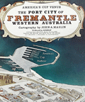 | Details | Maslin, John A. | 1985 |
| America's Cup pictorial bird-eye view of Freemantle, Western Australia |
|
Maslin, John A. |
|
| 1985 |
| LOC:1404 |
| $350.00 | Maslin--John-A- | America-s-Cup-pictorial-bird-eye-view-of-Freemantle--Western-Australia | Attractive oblique pictorial birds-eye view map of the town and harbor of Freemantle, Western Australia. July 1985 edition. Copyrighted and produced by Ausimap, Perth. Cartography by John A. Maslin.
<br><br>
In addition to Cockburn Sound and Freemantle Harbor the expansive birds-eye view shows Success Harbor, the fishing boat harbor, and the America's Cup harbour at Freemantle.
<br><br>
Two years before this map was published, and for the first time in 132 years, the America’s Cup was won by a team from other than the USA. That year, in Rhode Island, Australia II, skippered by John Bertrand defeated Dennis O'Conner on the Liberty. In 1987 the America's Cup race was held in Freemantle, Australia where the Stars & Stripes 87 won the series in a four-race sweep. |
| 6480 |  | Details | Anonymous | 1986 |
| Decorative serigraph poster San Francisco Bay Golden Gate Bridge |
|
Anonymous |
|
| 1986 |
| LOC:1404 |
| $875.00 | Anonymous | Decorative-serigraph-poster-San-Francisco-Bay-Golden-Gate-Bridge | Fine decorative nautical-themed limited-edition silk-screen poster of San Francisco Bay, California and the Golden Gate Bridge from the seventh-annual users conference held by Data Design Associates in 1986. Deep rich colors. Signed within (illegible, maybe Bob Williams ?). Number 127 of 600 copies.
<br><br>
Data Design Associates, Inc., was a Sunnyvale, Calif-based developer of mainframe financial software. |
| 6481 | 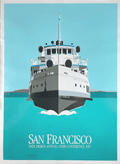 | Details | Anonymous | 1986 |
| Decorative serigraph poster City of San Francisco Ferry |
|
Anonymous |
|
| 1986 |
| LOC:1404 |
| $475.00 | Anonymous | Decorative-serigraph-poster-City-of-San-Francisco-Ferry | Fine decorative nautical-themed limited-edition silk-screen poster of San Francisco Bay, California and the ferry "City of San Francisco" from the eighth-annual users conference held by Data Design Associates in 1987. Deep rich colors. Signed within (illegible). Number 579 of 700 copies.
<br><br>
Data Design Associates, Inc., was a Sunnyvale, Calif-based developer of mainframe financial software. |
| 6482 | 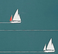 | Details | Anonymous | 1986 |
| Decorative serigraph poster San Francisco Bay and Coit Tower |
|
Anonymous |
|
| 1986 |
| LOC:1404 |
| $375.00 | Anonymous | Decorative-serigraph-poster-San-Francisco-Bay-and-Coit-Tower | Fine decorative nautical-themed limited-edition silk-screen poster of San Francisco Bay, California and Coit Tower from the fifth-annual users conference held by Data Design Associates in 1984. Deep rich colors. Signed within (illegible). Number 472 of 500.
<br><br>
Data Design Associates, Inc., was a Sunnyvale, Calif-based developer of mainframe financial software. |
| 6387 | 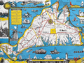 | Details | Parker, Larry | 1955 |
| Pictorial Map of Martha's Vineyard Island, Massachusetts |
|
Parker, Larry |
|
| 1955 |
| LOC:87 |
| $750.00 | Parker--Larry | Pictorial-Map-of-Martha-s-Vineyard-Island--Massachusetts | Original, scarce, 1950's Martha's Vineyard Island, Massachusetts pictorial map by Larry Parker. This lithographed tourist map features bright, bold colors, inset pictorial images of island life, and text blocks of historical facts, all hallmarks of a tourist souvenir map. Slight gloss to the paper finish as typical.
<br></br>
Remarkable condition.
<br></br>
This 1950's era edition is based on Parker's earlier 1935 black and white map of Martha's Vineyard Island. Not only does the new edition feature vivid lithographed color, several changes were made to the content including below the rope-wrapped bollard where the text "Edgartown Harbor" does not appear directly below the bollard. On this colored edition of Parker's map the area is blank. |
| 453 | 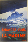 | Details | Theunissen, A. | 1930 |
| Engagez-vous dans la Marine |
|
Theunissen, A. |
|
| 1930 |
| LOC:0 |
| $650.00 | Theunissen--A- | Engagez-vous-dans-la-Marine | Large, dynamic, post-WWI recruiting poster for the French navy dated to 1930. Depicts a fast patrol boat or destroyer. <BR> </BR>
Lithograph, signed in the plate by A. Theunissen, followed by the symbol of an anchor which is one of the privileges accorded those artists who have been appointed as official "Peintre de la Marine". Theunissen was given that honor in 1925 by the French Minister of Defense in recognition of his artistic work for the French Navy or maritime subjects . Published by Devambez, Paris. 1930. |
| 451 | 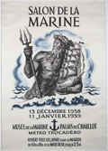 | Details | Decaris, Albert | 1958 |
| Salon de la Marine |
|
Decaris, Albert |
|
| 1958 |
| LOC:50 |
| $195.00 | Decaris--Albert | Salon-de-la-Marine | Very decorative medium-format original two-color poster shows <strong>Neptune</strong> grasping a trident while cradling a sailing vessel. The poster was produced to promote the Salon de la Marine, held in 1958 at the <strong>Paris Musee de la Marine.</strong> The Salon is an event held at the National Marine Museum in Paris to display maritime art by invited artists and by artists named as "Peintre de la Marine" or official marine painter.
<BR> </BR>
By <strong>Albert Decaris</strong>, one of France's top engravers in the 20th century. Decaris was honored with the post of the official painter of the Marine Française in 1962. |