| | Thumbnail | | Creator | Date | Title / Author / Date / Location | Price | | | Description |
| 820 | 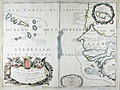 | Details | Coronelli, Vincenzo | 1692 |
| Antique map of Cape Verde Islands and West Africa |
|
Coronelli, Vincenzo |
|
| 1692 |
| LOC:54 |
| $650.00 | Coronelli--Vincenzo | Antique-map-of-Cape-Verde-Islands-and-West-Africa | Beautiful antique map of the Cape Verde Islands and West coast of Africa by cartographer and Franciscan monk Vicenzo Coronelli (1650 - 1718). The map was published from Venice in 1692 in Coronelli's atlas, the Atlante Veneto. Highly decorative title cartouche at bottom left with angels holding a large tapestry in front of a decorative garland. Inset of the African island of Goree at upper right corner. Goree was a trading post with some association to the Atlantic slave trade.
<br></br>
The Cape Verde islands were a stopping and revictualing location for numerous early explorers since their discovery by the Portuguese around 1456. In 1522 the famished crew of Ferdinand Magellan's ship Victoria, numbering about two dozen, stopped at the island of Santiago on their return from their record-setting circumnavigation of the earth. A bit more that 60 years later in 1585, Sir Francis Drake attacked and burned the town of Cidade Velha on the island of Santiago.
<br></br>
Seller's attribution at bottom left reads "Si vende presso Domenico Padoani sul ponte di Rialto all'Insegna della Geografia." Contains some soundings and marked anchorages but the intended use of the map was not for navigation but for general information and decoration. |