| | Thumbnail | | Creator | Date | Title / Author / Date / Location | Price | | | Description |
| 425 | 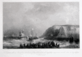 | Details | Gudin, Baron Theodore | |
| D'Espineville de Harfleur brule une flotte Hollandaise |
|
Gudin, Baron Theodore |
|
|
| LOC:89 |
| $90.00 | Gudin--Baron-Theodore | D-Espineville-de-Harfleur-brule-une-flotte-Hollandaise | This engraving depicts a battle in 1555 between twenty-two Dutch warships and twenty-five French off Dover in the English channel. During the battle five French vessels were set on fire. French crews jumped overboard and swam to the nearest vessel for safety, whether friend or foe. The Dutch recovered so many French sailors that it was impossible to guard them thoroughly, the result of which was that the rescued French sailors overpowered and captured five Dutch vessels and brought them as prizes to Dieppe. In all, 1000 Dutch and 400 French sailors are thought to have perished (although Dutch sources disagree). The French Admiral, d'Espineville was one of the casualties. <BR> </BR>
This fine work from the original 19th century plate, is a 20th century reprint from the Louvre of an etching and engraving on steel plate by Chavane. Subject matter is based on a painting by French Marine Painter Baron Theodore Gudin (1802-1880 ) in 1839. <BR> </BR>
With the circular embossed stamp of "Chalcographie Musee National du Louvre". La Chalcographie du Louvre is a repository of more that 13,000 plates from the Louvre's archives, housed upstairs above the Louvre's Paris galleries . Upon request visitors can have a engraving produced from one of those original plates by master printers on museum-quality paper. |
| 2506 | 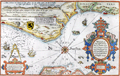 | Details | Waghenaer, Lucas Jansz | 1584 |
| Rare Dutch Sea chart of Belgium, Picardie, and France |
|
Waghenaer, Lucas Jansz |
|
| 1584 |
| LOC:9 |
| $1,800.00 | Waghenaer---Lucas-Jansz | Rare-Dutch-Sea-chart-of-Belgium--Picardie--and-France | A treasure! Chart of the English Channel printed in 1584, four years before the "Invincible Armada" of Spain was defeated in their attempt to conquer England. Extends from Nieuwpoort to Dieppe. With two coastal profiles. French text edition. Published in Leiden by Plantin. |
| 123 |  | Details | Braun and Hogenberg | 1598 |
| Caletum |
|
Braun and Hogenberg |
|
| 1598 |
| LOC:89 |
| $850.00 | Braun-and-Hogenberg | Caletum | A decorative antique view / plan of Callais, France by Braun and Hogenberg. The engraving records a brief moment in history 1596 - 1598 during which Callais was taken from the French and occupied by Spain. This was a tumultuous time, less than a decade after the failed "invincible armada" in which Spain attempted to invade and occupy England. Shown in the foreground near the landward drawbridge are two Spanish soldiers- a pike man and an arquebusier. The depiction of Dover, England at the far top of the engraving is a reminder of Callais' strategic position on the English Channel. |
| 1284 |  | Details | Ortelius, Abraham | 1599 |
| Antique Ortelius map of Brittany, France |
|
Ortelius, Abraham |
|
| 1599 |
| LOC:0 |
| $0.00 | Ortelius--Abraham | Antique-Ortelius-map-of-Brittany--France | SOLD
<br><br/>
Attractive, antique miniature map of Brittany in France with a stipple engraved sea, showing the region from Granville to the mouth of the Loire River. This fine map of Brittany in north west France suggests the importance of rivers and coasts for sixteenth century transportation. The rivers are exagerrated in their size as are the main settlements such as Rennes, St Malo, Brest, Vannes and Nantes.
<br></br>
Published by Giovanni Botero, an Italian priest and geographer, in 'Relationi Universali'. The 1599 edition of that work is noteworthy for using a complete set of Ortelius miniature maps engraved by Pietro Marchetti.
<br></br>
Set in a page of Italian text with text also on the verso. From Book I, page 48. |
| 171 |  | Details | Anonymous | 1600 |
| Des Dieux |
|
Anonymous |
|
| 1600 |
| LOC:0 |
| $50.00 | Anonymous | Des-Dieux | Fanciful antique woodblock engraving of a small galley. French text at bottom and verso. Vines cover the mast, oars and rudder and several lions are seen on deck while in the foreground two sea creatures swim menacingly. Ca 1600. Unknown origin. Page 543. |
| 1205 | 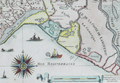 | Details | Tassin, Christophe Nicholas | 1634 |
| Antique coastal map of the Captainerie de Agde and Coast of Languedoc |
|
Tassin, Christophe Nicholas |
|
| 1634 |
| LOC:7 |
| $480.00 | Tassin--Christophe-Nicholas | Antique-coastal-map-of-the-Captainerie-de-Agde-and-Coast-of-Languedoc | Scarce antique engraved, 380 year-old map of the <b>Languedoc</b> region (coastal areas of France including the Camargue with villages of Montpellier, Aigues-Mortes, and La Motte) by French cartographer Christophe Nicholas Tassin. Contains a beautifully designed and intricately engraved compass rose with 32 points. Decorated with small sailing vessels (including a galley) and a <b>fantastical sea monster</b>. Scrollwork distance scale in French lieue.
<br></br>
This rare antique map is not from the common series of town views in pocket atlas format published by Tassin but from the earliest atlas of charts specifically of coastal areas published by Tassin in France ca. 1634: "Cartes Generale et Particulieres de toutes le costes de France Tant de la Mer Oceane que Mediterranee"...
<br></br>
See
<a href="http://gallica.bnf.fr/ark:/12148/btv1b77100033. " target="_blank">this page</a> at the Bibliotheque national de France for all the maps in Tassin's scare coastal atlas.
<br></br>
Attribution at bottom reads: "Par Sieur Tassin Geographe ordinaire de ca Majeste. Par Privilege du Roy." Tassin's background was as a military engineer and his works often show militarily important sites, either sketched on site, composed from firsthand drawings by military engineers, or sometimes borrowed from other mapmakers. Additionally, Christophe Tassin also published several small sized atlases with profiles of French towns and maps of the provinces.
<br></br>
Published in Paris by Chez Melchior Tavernier, en lisle du Palais, vis à vis la quay de la Megisserie. |
| 656 | 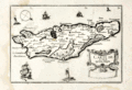 | Details | Tassin, Christophe Nicholas | 1634 |
| Carte de l'Isle de Oleron |
|
Tassin, Christophe Nicholas |
|
| 1634 |
| LOC:4 |
| $160.00 | Tassin--Christophe-Nicholas | Carte-de-l-Isle-de-Oleron | Small, attractive map of the island of Oleron in the Bay of Biscay in Western France, just off the coast in the Atlantic Ocean. Oleron is France's second largest island, after Corsica.
<br></br>
Shows a great deal of interior detail as small as individual buildings, churches, windmills, and gardens. This map is a variant similar to but substantially different from the version published by Tassin in "Les Plans et profils de toutes les principales villes et lieux considerables de France" . This more scarce version contains a compass rose, the cartouche appears at bottom right, and the ships and interior island details are different.
<br></br>
Published by Tavernier in one of the many small-sized atlases created by Christophe Nicholas Tassin (d. 1660) . Tassin's background was as a military engineer, and he is best known for his nautical atlas of 30 sheets, dedicated to Richelieu, documenting France's coastline. Tassin's works contain topographic maps, often of militarily important sites, either sketched on site, composed from firsthand drawings by military engineers, or sometimes borrowed from other mapmakers. Plate 30. |
| 660 |  | Details | Tassin, Christophe Nicholas | 1634 |
| Cartes Generale et Particulieres de toutes le costes de France |
|
Tassin, Christophe Nicholas |
|
| 1634 |
| LOC:1 |
| $475.00 | Tassin--Christophe-Nicholas | Cartes-Generale-et-Particulieres-de-toutes-le-costes-de-France | Extraordinary engraved and very scarce 13" x 9" sea-atlas title page by French cartographer Christophe Nicholas Tassin. Contains scrollwork, angels, garlands, and a flat frog-like creature. A beautiful example of 17th century copperplate engraved art. This title page is not from the common series of town views in pocket atlas format published by Tassin.
<br></br>
This title page is from the earliest sea atlas published in France ( 1634 ) by Christophe Tassin. That atlas of 32 plates depicts hydrographic and topographic details of the French coast.
<br></br>
See this site for charts in Tassin's rare atlas: http://gallica.bnf.fr/ark:/12148/btv1b77100033.
<br></br>
Attribution at bottom reads: "Par Sieur Tassin Geographe ordinaire de ca Majeste. Par Privilege du Roy." Tassin's background was as a military engineer. Tassin's work contains topographic maps, often of militarily important sites, either sketched on site, composed from firsthand drawings by military engineers, or sometimes borrowed from other mapmakers. Additionally, Christophe Tassin also published several small sized atlases with profiles of French towns and maps of the provinces.
<br></br>
Published in Paris by Chez Melchior Tavernier, en lisle du Palais, vis à vis la quay de la Megisserie. |
| 739 |  | Details | Tassin, Christophe Nicholas | 1634 |
| Antique Chart of the Guyenne and Biscay Coasts |
|
Tassin, Christophe Nicholas |
|
| 1634 |
| LOC:0 |
| $0.00 | Tassin--Christophe-Nicholas | Antique-Chart-of-the-Guyenne-and-Biscay-Coasts | SOLD
<br></br>
Antique engraved and very scarce 380 year-old chart of the Basque Region (coastal areas of Spain and France directly north of the Pyrenees mountains) by French cartographer Christophe Nicholas Tassin. The chart was published in 1634 as part of Tassin's "Cartes Generale et Particulieres de toutes le costes de France Tant de la Mer Oceane que Mediterranee"... Coverage includes the "Coste de Guyenne" (archaic name for the Aquitaine region of France) with Saint-Jean-de-Luz, Biarritz ,and Bayonne, France. In Spain, San Sebastien, Pasaia (le Pasage), Hondarribia (Funtarabie) on the Biscayan Coast.
<br></br>
This rare antique chart is not from the common series of town views in pocket atlas format published by Tassin but from the earliest atlas of charts specifically of coastal areas published by Tassin in France ca. 1634. Contains a beautifully designed and intricately engraved compass rose with sixteen points. Surrounded by small sailing vessels and a fantastical sea monster.
<br></br>
See
<a href="http://gallica.bnf.fr/ark:/12148/btv1b77100033. " target="_blank">this page</a> at the Bibliotheque national de France for all the maps in Tassin's scare coastal atlas.
<br></br>
Nicholas Tassin's background included a long period of employment as a military engineer and his printed works often show militarily important sites, either sketched on site, composed from firsthand drawings by military engineers, or sometimes borrowed from other mapmakers. Additionally, Tassin also published several small sized atlases with inspired profiles of French towns and maps of the provinces.
<br></br>
Published in Paris: Chez Melchior Tavernier, en lisle du Palais, vis à vis la quay de la Megisserie. |
| 655 | 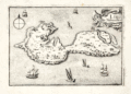 | Details | Tassin, Christophe Nicholas | 1634 |
| Isle de Noirmoutier |
|
Tassin, Christophe Nicholas |
|
| 1634 |
| LOC:0 |
| $0.00 | Tassin--Christophe-Nicholas | Isle-de-Noirmoutier | SALE IS PENDING
<br></br>
Small, attractive map of the island of Noirmoutier, France in the Pays de Loire region of Western France, just off the coast in the Atlantic Ocean. Price includes standard international shipping.
<br></br>
The map shows a great deal of interior detail as small as individual buildings, churches, windmills, and gardens. Offshore, small sailing vessels fill up the empty space. This map is a variant similar to but substantially different from the version published by Tassin in "Les Plans et profils de toutes les principales villes et lieux considerables de France" . This more scarce version contains a compass rose, the cartouche appears at top right, and the ships and interior island details are different. This version of the map is also a variant of the copy held by the Bibliothèque nationale de France. Plate 28.
<br></br>
Published by Tavernier in one of the many small-sized atlases created by Christophe Nicholas Tassin (d. 1660) . Tassin's background was as a military engineer, and he is best known for his nautical atlas of 30 sheets, dedicated to Richelieu, documenting France's coastline. Tassin's work contains topographic maps, often of militarily important sites, either sketched on site, composed from firsthand drawings by military engineers, or sometimes borrowed from other mapmakers. |
| 1360 | 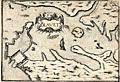 | Details | Tassin, Christophe Nicholas | 1636 |
| Antique map of the Port of Blavet, France |
|
Tassin, Christophe Nicholas |
|
| 1636 |
| LOC:0 |
| $0.00 | Tassin--Christophe-Nicholas | Antique-map-of-the-Port-of-Blavet--France | SOLD
<br></br>
Antique copper-plate engraved map of the Port of Blavet by C.N. Tassin. The map covers a small area in the southern Brittany region of France, near Lorient at the mouth of the Canal du Blavet. One of the earlest available maps to feature a plan of the Citadelle de Port-Louis, built in the 16th century. Alain Mallet's engraving titled "Plan de la Ville et du Fort de Blavet" is amost an exact copy of Tassin's earlier work.
<br></br>
Archivally matted. With mat measures 12" W x 10" H.
<br></br>
Published in the small-sized atlas "Les Plans et profils de toutes les principales villes et lieux considerables de France" by Christophe Nicholas Tassin (d. 1660) . Tassin's background was as a military engineer, and he is best known for his nautical atlas of 30 sheets, dedicated to Richelieu, documenting France's coastline. Tassin's work contains topographic maps, often of militarily important sites, either sketched on site, composed from firsthand drawings by military engineers, or sometimes borrowed from other mapmakers. |
| 1359 | 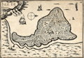 | Details | Tassin, Christophe Nicholas | 1636 |
| Antique map of the Isle de Bouin, France |
|
Tassin, Christophe Nicholas |
|
| 1636 |
| LOC:0 |
| $80.00 | Tassin--Christophe-Nicholas | Antique-map-of-the-Isle-de-Bouin--France | Decorative antique island map of Bouin, France- an island, located in the Breton marshes that exists no more. Created by Nicolas Tassin in 1636, this neat small map shows what was the <b>Isle of Bouin</b> , a commune in the western Pays de la Loire region of France. At the time of our map Tassin shows almost every square foot covered with houses, roads, or ponds.
<br></br>
Archivally matted. With mat measures 12" W x 10" H.
<br></br>
The isle of Bouin no longer exists as such because over time the narrow channel separating the island from the mainland silted up, and the island became part of the mainland. The town of Bouin still exists.
<br></br>
Published in the small-sized atlas "Les Plans et profils de toutes les principales villes et lieux considerables de France" by Christophe Nicholas Tassin (d. 1660) . Tassin's background was as a military engineer, and he is best known for his nautical atlas of 30 sheets, dedicated to Richelieu, documenting France's coastline. Tassin's work contains topographic maps, often of militarily important sites, either sketched on site, composed from firsthand drawings by military engineers, or sometimes borrowed from other mapmakers. |
| 999 |  | Details | Tassin, Christophe Nicholas | 1636 |
| Antique title page for Dauphiné province in France |
|
Tassin, Christophe Nicholas |
|
| 1636 |
| LOC:50 |
| $95.00 | Tassin--Christophe-Nicholas | Antique-title-page-for-Dauphiné-province-in-France | Beautiful hand-colored, engraved sectional title page for Tassin's small atlas of French towns. This example is for the chapter containing the province of Dauphiné, in southeastern France. This title page with its scrollwork cartouche is topped with a whimical insect head. A very fine example of 17th century engraving craftsmanship and artistry.
<br></br>
Published in the small-sized atlas "Les Plans et profils de toutes les principales villes et lieux considerables de France" by Christophe Nicholas Tassin (d. 1660) . Tassin's background was as a military engineer, and he is best known for his nautical atlas of 30 sheets, dedicated to Richelieu, documenting France's coastline. Tassin's work contains topographic maps, often of militarily important sites, either sketched on site, composed from firsthand drawings by military engineers, or sometimes borrowed from other mapmakers. |
| 1000 | 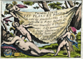 | Details | Tassin, Christophe Nicholas | 1636 |
| Antique title page for Tassins French town atlas |
|
Tassin, Christophe Nicholas |
|
| 1636 |
| LOC:0 |
| $0.00 | Tassin--Christophe-Nicholas | Antique-title-page-for-Tassins-French-town-atlas | SOLD<br></br>
Beautiful antique title page for the "Premiere Partie" or first part of Tassin's small atlas of French towns. This hand-colored copper-engraved title page shows cherubs stretching a sheet bearing the title over a sleeping nude female figure. Resting near the nude are a globe, backstaff (an early navigational instrument), and a compass, each reflecting Tassin's interest in cartography. A substantially fine example of 17th century engraving craftsmanship and artistry.
<br></br>
Published in the small-sized atlas "Les Plans et profils de toutes les principales villes et lieux considerables de France" by Christophe Nicholas Tassin (d. 1660) . Tassin's background was as a military engineer, and he is best known for his nautical atlas of 30 sheets, dedicated to Richelieu, documenting France's coastline. Tassin's work contains topographic maps, often of militarily important sites, either sketched on site, composed from firsthand drawings by military engineers, or sometimes borrowed from other mapmakers. |
| 140 | 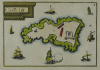 | Details | Tassin, Christophe Nicholas | 1636 |
| Chateau d'If |
|
Tassin, Christophe Nicholas |
|
| 1636 |
| LOC:0 |
| $0.00 | Tassin--Christophe-Nicholas | Chateau-d-If | SOLD<BR> </BR>
Scarce antique island map by Nicolas Tassin from 1636. Highly decorative map shows the island fortress, Chateau d'If, on the island of If located in the Bay of Marseilles, close offshore from the town of Marseilles. The engraving shows the island, surrounded by numerous galleys and other sailing vessels. At the time this engraving was made Marseille was the primary Mediterranean base for the French Corps des Galeres.
<br></br>
Published in the small-sized atlas "Les Plans et profils de toutes les principales villes et lieux considerables de France" by Christophe Nicholas Tassin (d. 1660) . Tassin's background was as a military engineer, and he is best known for his nautical atlas of 30 sheets, dedicated to Richelieu, documenting France's coastline. Tassin's work contains topographic maps, often of militarily important sites, either sketched on site, composed from firsthand drawings by military engineers, or sometimes borrowed from other mapmakers. |
| 141 | 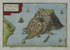 | Details | Tassin, Christophe Nicholas | 1636 |
| Fort de Brigancon |
|
Tassin, Christophe Nicholas |
|
| 1636 |
| LOC:4 |
| $195.00 | Tassin--Christophe-Nicholas | Fort-de-Brigancon | Scarce antique island map by Christophe N. Tassin from 1636. Depicts the Fort of Bregancon near Toulon which is the official retreat for the President of France. The island today looks very much the same as this copperplate engraved view created more than 360 years ago .
<br></br>
Published in the small-sized atlas "Les Plans et profils de toutes les principales villes et lieux considerables de France" by Christophe Nicholas Tassin (d. 1660) . Tassin's background was as a military engineer, and he is best known for his nautical atlas of 30 sheets, dedicated to Richelieu, documenting France's coastline. Tassin's work contains topographic maps, often of militarily important sites, either sketched on site, composed from firsthand drawings by military engineers, or sometimes borrowed from other mapmakers. |
| 149 | 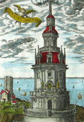 | Details | Tassin, Christophe Nicholas | 1636 |
| Tour de Corduan |
|
Tassin, Christophe Nicholas |
|
| 1636 |
| LOC:0 |
| $350.00 | Tassin--Christophe-Nicholas | Tour-de-Corduan | <b>A recommended item</b> for any collector of maritime, lighthouse, or nautical antiques. Should appeal to collectors of coastal charts of France. Very unusual and quite interesting engraving from Tassin who produced almost exclusively charts and plans of the French coast and little else.
<br></br>
Extremely scarce antique view of the lighthouse "Tower of Corduan" ca. 1636 after an earlier work by Claude Châtillon in 1612. The "Tour de Corduan" is the oldest lighthouse in France and one of the oldest lighthouses in the world. The structure was completed in 1611, more than 35 years after its initial design by Louis de Foix.
<br></br>
Sometimes called the King of Lighthouses because of its large size and extravagant construction details, Le Phare Corduan marks the entrance to the Gironde river near Royan, France. As is common with Tassin engravings numerous sailing vessels are shown offshore the lighthouse, with one firing a blast from its cannon.
<br></br>
Published in the small-sized atlas "Les Plans et profils de toutes les principales villes et lieux considerables de France" by Christophe Nicholas Tassin (d. 1660) . Tassin's background was as a military engineer, and he is best known for his nautical atlas of 30 sheets, dedicated to Richelieu, documenting France's coastline. Tassin's work contains topographic maps, often of militarily important sites, either sketched on site, composed from firsthand drawings by military engineers, or sometimes borrowed from other mapmakers. |
| 983 | 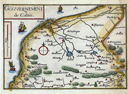 | Details | Tassin, Christophe Nicholas | 1636 |
| Antique map of the Calais, France environs by Tassin |
|
Tassin, Christophe Nicholas |
|
| 1636 |
| LOC:7 |
| $110.00 | Tassin--Christophe-Nicholas | Antique-map-of-the-Calais--France-environs-by-Tassin | Antique map by Nicolas Tassin of the vicinity around Calais, France on the English Channel. Key features include the towns of Calais and Ardres and the Riviere de Graveline. The map is dotted with numerous smaller villages. Sailing ships cruise offshore, a typical decorative feature of Tassin's maps.
<br></br>
Published in the small-sized atlas "Les Plans et profils de toutes les principales villes et lieux considerables de France" by Christophe Nicholas Tassin (d. 1660) . Tassin's background was as a military engineer, and he is best known for his nautical atlas of 30 sheets, dedicated to Richelieu, documenting France's coastline. Tassin's work contains topographic maps, often of militarily important sites, either sketched on site, composed from firsthand drawings by military engineers, or sometimes borrowed from other mapmakers. |
| 152 | 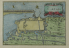 | Details | Tassin, Christophe Nicholas | 1636 |
| Calais |
|
Tassin, Christophe Nicholas |
|
| 1636 |
| LOC:7 |
| $110.00 | Tassin--Christophe-Nicholas | Calais | Antique engraved view of the town and harbor of Calais, France by the author of an atlas on French towns and villages- Christophe Nicolas Tassin. This small copperplate engraving focuses on the nearby area surrounding the town of Calais, its fortifications, and hydraulic plan. With a decorative title cartouche of two sea serpents.
<br></br>
Published in the small-sized atlas "Les Plans et profils de toutes les principales villes et lieux considerables de France" by Christophe Nicholas Tassin (d. 1660) . Tassin's background was as a military engineer, and he is best known for his nautical atlas of 30 sheets, dedicated to Richelieu, documenting France's coastline. Tassin's work contains topographic maps, often of militarily important sites, either sketched on site, composed from firsthand drawings by military engineers, or sometimes borrowed from other mapmakers. |
| 1365 | 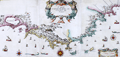 | Details | Tassin, Christophe Nicholas | 1638 |
| NOT AVAILABLE Magnificent Antique Map of the Coast of Provence, France |
|
Tassin, Christophe Nicholas |
|
| 1638 |
| LOC:0 |
| $0.00 | Tassin--Christophe-Nicholas | NOT-AVAILABLE-------Magnificent-Antique-Map-of-the-Coast-of-Provence--France | What a stunning and special map! Spectacular large nautical map of the coastline of Provence, France and Languedoc. Beautiful decorative map (1638) by Christophe Nicolas Tassin shows the French coastline from Port-de-Bouc to Nice. Includes a large, decorative title cartouche, 18 galleys and other sailing vessels, several sea monsters and three gorgeous compass roses. Done in a style somewhat unique to Tassin, with outlandish creatures comprising the cartouches and numerous ships and aquatic sea monsters filling the empty spaces on the map.
<br></br>
In 3 sheets joined, now restored and laid to linen. Without the attribution to Tassin "Geographe ordinaire" or the date.
<br></br>
Tassin's background was as a military engineer. Tassin's work contains topographic maps, often of militarily important sites, either sketched on site, composed from firsthand drawings by military engineers, or sometimes borrowed from other mapmakers. Additionally, Christophe Tassin also published several small sized atlases with profiles of French towns and maps of the provinces.
<br></br>
A very early map from Tassin who authored the first atlas of the French coast "Cartes Generale et Particulieres de toutes le costes de France" in 1634. This map from Tassin's "Les cartes generales de toutes les provinces de France royaumes et provinces de l'Europe. Revues corrigées & augmentées par le Sieur Tassin geographe ordinaire de sa Magesté" |
| 600 | 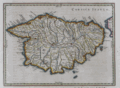 | Details | Jansson, Jan | 1657 |
| Het Eylandt Corsica |
|
Jansson, Jan |
|
| 1657 |
| LOC:8 |
| $0.00 | Jansson--Jan | Het-Eylandt-Corsica | SOLD<br><br>
Antique Dutch map of the French island of Corsica ( Corse ), in the Mediterranean Sea from ca. 1657 by Jan Jansson. Jansson (1588-1664) was a Dutch publisher and map maker from Amsterdam.
<br></br>
This nautical map is an original antique, over 350 years old and is oriented with North to the left. Prominent coastal details that are featured include: San Bonifacio strait, Golfo S. Fiorenzo, Golfo de Genarca, Golfo Aiazzo, Gollfo de Talabo, and at the far West, Capo Corsa.
<br></br>
On a folio-sized page with Dutch text on both the recto and verso related to the geography of that island.
<br></br>
Page 21. |
| 2577 | 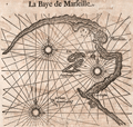 | Details | Goos, Pieter | 1669 |
| 17th century woodblock chart of Marseilles, France |
|
Goos, Pieter |
|
| 1669 |
| LOC:77 |
| $185.00 | Goos--Pieter | 17th-century-woodblock-chart-of-Marseilles--France | Two woodblock charts (verso and recto) of the Bay of Marseille, France and of the coast and islands of the Bay of Hyeres: Porquerolles, Port Cros, Ile du Levant. Scarce.
<br></br>
Produced by Dutch cartographer Pieter Goos from Amsterdam in 1669. |
| 4742 | 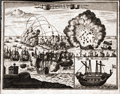 | Details | Anonymous | 1680 |
| Antique engraving of the bombardment of St. Malo France |
|
Anonymous |
|
| 1680 |
| LOC:77 |
| $150.00 | Anonymous | Antique-engraving-of-the-bombardment-of-St--Malo-France | Anonymous antique engraved print of the bombardment of St. Malo, France, probably during the 17th century. Decorative unusual copper engraved map ca. 1680 showing a naval siege of Saint-Malo, France. The plate show the city with its buildings, churches, harbor and town walls. Inset showing a warship "Das Machine Schiff" (probably a bomb vessel). Verso blank. |
| 1392 |  | Details | Mallet, Allain Manesson | 1683 |
| Antique map of the ancient Gaul |
|
Mallet, Allain Manesson |
|
| 1683 |
| LOC:7 |
| $120.00 | Mallet--Allain-Manesson | Antique-map-of-the-ancient-Gaul | Original antique engraved map of the ancient area controlled by the Gauls ca 1st century BC with territory identified for the Gallic tribes including Belgica, Aquitania, and Celtica. French text on verso.
<br></br>
From Mallet's "Description de l'Univers, contenant les differents systemes du Monde, les Cartes generales & particulieres de la Geographie Ancienne & Moderne . . . " By Allain Manesson Mallet. Paris, Chez Denys Thierry, Rue S. Jacques. Figure 55. Page 135. |
| 621 |  | Details | Arnaves, J. | 1683 |
| Naval Architecture- Pieces of an First Rate French Warship circa 1683 |
|
Arnaves, J. |
|
| 1683 |
| LOC:55 |
| $2,600.00 | Arnaves--J- | Naval-Architecture--Pieces-of-an-First-Rate-French-Warship-circa-1683 | Highly interesting and very rare graphical parts diagram of all the pieces used in the construction of a French first-rate ship-of-the line, including structural members. This is an antique original copperplate engraved print dated within to 1683. Attribution at bottom left is to the creator "J. Arnave fec(it)" but the original inspiration for the work is attributed within an inset to Francois Coullomb: "Faict a Toulon dans lescolle de la construction par Francois Coullomb Fitz avec permission 1683." <br></br>
The original usage of the diagram by Coullomb was as a large wall chart for students at the royal shipyard at Toulon, France. Includes ( in French ) the name, count, and size of each piece. The pieces shown include frames, longitudinals, knees, bitts, grates, masts, capstans, ladders, cannon, anchors, rudder, and numerous decorative trim. <br></br>
This work was probably bound into a copy of Henri Sbonski de Passebon's "Plan de Plusieurs Batiments de Mer avec leurs Proportions" a volume of engravings dedicated to late 17th century nautical architecture. <br></br>
Published from Toulon, France, the home to the regular French naval forces ( Vaisseaux ). |
| 988 |  | Details | Mallet, Allain Manesson | 1684 |
| Plan of Dunkirk, France by Mallet |
|
Mallet, Allain Manesson |
|
| 1684 |
| LOC:7 |
| $60.00 | Mallet--Allain-Manesson | Plan-of-Dunkirk--France-by-Mallet | Small antique hand-colored plan of Dunkirk / Dunkerque, France. The plan shows the town with moats and surrounded by at least three walls. At the port Mallet shows several ships entering from offshore.
<br></br>
From "Les Travaux de Mars ou l'Art de la Guerre " in 3 volumes. Paris, 1684. Figure LXVII . French text on verso. Page 213. |
| 305 |  | Details | Henri Sbonski de Passebon | 1690 |
| La galere Patronne a la rame |
|
Henri Sbonski de Passebon |
|
| 1690 |
| LOC:50 |
| $1,100.00 | Henri-Sbonski-de-Passebon | La-galere-Patronne-a-la-rame | "La galere (galère, Fr.) patronne a la rame" is one of a series of 17 antique folio-sized copperplate engravings created ca. 1690 by French galley Captain Henry Sbonski de Passebon. This print was engraved by Claude Randon, as part of a volume of nautical architecture plates first published from Marseille where, in the late 17th century the arsenal was home port to the galley service of Louis XIV.<BR> </BR>
<a style="color:#9BAFCB" rel="nofollow" href= "/SbonskiPassebonBackground.aspx">View other
Sbonski de Passebon engravings</a>
<BR> </BR>
De Passebon was stationed at Marseilles as a Lieutenant in the Corps des Galeres during the period that he produced the drawing from which this antique print was engraved. Therefore this plate, drawn from first-hand observation, is perhaps the best record of the Patronne available. There was only one Patronne in the Galley Corps, typically reserved for the Lieutenant General des Galeres and the Patronne was second in prominence and beauty only to the royal galley, the Reale.<BR> </BR>
<br>Attribution at bottom left: "Randon delineauit et sculpsit cura D'ni de Passebon Equitis"
<br>Royal privilege at bottom right: "Marsiliae cum privilegio Regis"
<br>Seller's attribution: "Se vendent a Marseilles chez Laurent Bremond sur le port au Coin de reboul" |
| 306 | 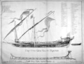 | Details | Henri Sbonski de Passebon | 1690 |
| Coupe d'une galere avec ses proportions |
|
Henri Sbonski de Passebon |
|
| 1690 |
| LOC:50 |
| $1,400.00 | Henri-Sbonski-de-Passebon | Coupe-d-une-galere-avec-ses-proportions | "Coupe d'une galere avec ses proportions" is one of a series of 17 antique folio-sized copperplate engravings created ca. 1690 by <strong>French galley Captain Henry Sbonski de Passebon.</strong> Scarce cutaway print of a standard late <strong>17th century French galley</strong> (galère, Fr.) with a detailed legend of parts (in French). Below the galley is a representation of the keel-form at the shipyard on which the keel was apparently built up. Very scarce.
<BR> </BR>
<a style="color:#9BAFCB" rel="nofollow" href= "/SbonskiPassebonBackground.aspx">View all Sbonski de Passebon engravings</a>
<BR> </BR>
Engraved by Barthelemy Chasse, the collection of nautical architecture plates was first published from Marseille where, in the late 17th century the arsenal was home port to the galley service of Louis XIV. This is the only plate in the volume engraved by Chasse. All other plates were engraved by Claude Randon.
<BR> </BR>
De Passebon was stationed at Marseilles as a Lieutenant in the Corps des Galeres during the period that he produced the drawings from which these plates were engraved.
<BR> </BR>
Attribution at bottom left: "Randon delineauit et sculpsit cura D'ni de Passebon Equitis"
<BR></BR>Royal privilege at bottom right: "Marsiliae cum privilegio Regis"
<BR></BR>Seller's attribution: <strong>"Se vendent a Marseilles chez Laurent Bremond sur le port au Coin de reboul"</strong> (Sold by Laurent Bremond from the port [Marseille] at the corner of Reboul [street].) |
| 307 |  | Details | Henri Sbonski de Passebon | 1690 |
| Flute vaisseau de charge a la voile |
|
Henri Sbonski de Passebon |
|
| 1690 |
| LOC:0 |
| $0.00 | Henri-Sbonski-de-Passebon | Flute-vaisseau-de-charge-a-la-voile | SOLD
<br></br>
"Flute vaisseau de charge a la voile" is one of a series of 17 antique folio-sized copperplate engravings created ca. 1690 by French galley Captain Henry Sbonski de Passebon. Engraved by Claude Randon, the collection of nautical architecture plates was first published from Marseille where, in the late 17th century the arsenal was home port to the galley service of Louis XIV.<BR> </BR>
A flute ( fluyt ; pronounced 'flight') was typically a cargo-carrying vessel of about 80 feet in length and displaced between 200 - 300 tons.<br></br>
<a style="color:#9BAFCB" rel="nofollow" href= "http://en.wikipedia.org/wiki/Fluyt"> According to Wikipedia the fluyt </a> was one of the keys to Dutch commercial competitiveness in the 17th century as it: <i>"... was designed to facilitate transoceanic delivery with the maximum of space and crew efficiency. Unlike rivals, it was not built for conversion in wartime to a warship, so it was cheaper to build and carried twice the cargo, and could be handled by a smaller crew. Construction by specialized shipyards using new tools made it half the cost of rival ships. The factors combined to sharply lower the cost of transportation for Dutch merchants, giving them a major competitive advantage."</i>
<br></br>
<a style="color:#9BAFCB" rel="nofollow" href= "/SbonskiPassebonBackground.aspx">View all Sbonski de Passebon engravings</a>
<BR> </BR>
De Passebon was stationed at Marseilles as a Lieutenant in the Corps des Galeres during the period that he produced the drawings from which these plates were engraved. <BR> </BR>
<br>Attribution at bottom left: "Randon delineauit et sculpsit cura D'ni de Passebon Equitis"
<br>Royal privilege at bottom right: "Marsiliae cum privilegio Regis"
<br>Seller's attribution: "Se vendent a Marseilles chez Laurent Bremond sur le port au Coin de reboul" |
| 308 |  | Details | Henri Sbonski de Passebon | 1690 |
| Galeasse a la voile |
|
Henri Sbonski de Passebon |
|
| 1690 |
| LOC:0 |
| $5,000.00 | Henri-Sbonski-de-Passebon | Galeasse-a-la-voile | Antique engraved print titled "Galeasse a la voile" depicts a Venetian galeazza (galeasse) under full sail. We know the vessel is from Venice, Italy because under close inspection one can see the faint outline of the Lion of St. Marks on the flag at the very top of the main mast. A galeasse is a larger vessel than a galley (galère, Fr.) typically powered by 3 lateen-rigged sails as well as oars. <BR> </BR>
This highly detailed plate is one of a series of 17 folio-sized antique copperplate engravings created ca. 1690 by French galley Captain Henry Sbonski de Passebon. Engraved by Claude Randon, the volume of nautical architecture plates was first published from Marseille where, in the late 17th century the arsenal was home port to the galley service of Louis XIV.<BR> </BR>
<a style="color:#9BAFCB" rel="nofollow" href= "/SbonskiPassebonBackground.aspx">View all Sbonski de Passebon engravings</a>
<BR> </BR>
De Passebon was stationed at Marseilles as a Lieutenant in the Corps des Galeres during the period that he produced the drawings from which these plates were engraved. <BR> </BR>
<br>Attribution at bottom left: "Randon delineauit et sculpsit cura D'ni de Passebon Equitis"
<br>Royal privilege at bottom right: "Marsiliae cum privilegio Regis"
<br>Seller's attribution: "Se vendent a Marseilles chez Laurent Bremond sur le port au Coin de reboul" |
| 309 |  | Details | Henri Sbonski de Passebon | 1690 |
| Galiote a bombe |
|
Henri Sbonski de Passebon |
|
| 1690 |
| LOC:0 |
| $2,400.00 | Henri-Sbonski-de-Passebon | Galiote-a-bombe | 'Galiote a bombe' or 'bomb galiote' is an antique folio-sized copperplate engraving created ca. 1690 by French galley Captain Henry Sbonski de Passebon. This original antique engraving is the earliest readily available rendering of a bomb vessel. No doubt de Passebon was intimately familiar with this type ship- he is reported to have participated in the French bombardment of Genoa in 1684. Engraved by Claude Randon, this example is one of 17 ship engravings in a collection of nautical architecture plates first published from Marseille where, in the late 17th century the arsenal was home port to the galley service of Louis XIV. <BR> </BR>
A 'Bomb Vessel' or 'Bomb Ketch' was typically 60 to 70 feet long and drew 8 or 9 feet of water. This relatively shallow draft would have enabled the vessels to approach closer to their target, One authoritative source defines 'Bomb Vessel' : as <div class="indenttextblock">"a ship of the old sailing navies armed with one or occasionally two, heavy howitzers or mortars and used for bombarding places ashore. Mostly the mortars were fitted in ketches either specially built or converted into such from a small three-masted vessel by the removal of her foremast to provide a good deck space forward for the mortars. When employed in bombardment, bomb vessels were moored in position with springs on their cables so that the ships themselves were trained for the mortars to fire on the desired bearing."(Oxford Companion to Ships and The Sea, Peter Kemp, ed. Oxford University Press. London, 1976, p. 93.)</div>In this example it can be seen clearly that the foremast had been removed as described above.<br></br>
De Passebon was stationed at Marseilles as a Lieutenant in the Corps des Galeres during the period that he produced the drawings from which these plates were engraved. |
| 310 | 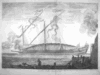 | Details | Henri Sbonski de Passebon | 1690 |
| La galere reale a la fonde |
|
Henri Sbonski de Passebon |
|
| 1690 |
| LOC:0 |
| $1,400.00 | Henri-Sbonski-de-Passebon | La-galere-reale-a-la-fonde | "La galere reale a la fonde" is one of a series of 17 folio-sized antique copperplate engravings created ca. 1690 by French galley Captain Henry Sbonski de Passebon. Engraved by Claude Randon, the collection of nautical architecture plates was first published from Marseille where, in the late 17th century the arsenal was home port to the galley (galère, Fr.) service of Louis XIV.<BR> </BR>
<a style="color:#9BAFCB" rel="nofollow" href= "/SbonskiPassebonBackground.aspx">View all Sbonski de Passebon engravings</a>
<BR> </BR>
De Passebon was stationed at Marseilles as a Lieutenant in the Corps des Galeres during the period that he produced the drawings from which these plates were engraved. <BR> </BR>
<br>Attribution at bottom left: "Randon delineauit et sculpsit cura D'ni de Passebon Equitis"
<br>Royal privilege at bottom right: "Marsiliae cum privilegio Regis"
<br>Seller's attribution: "Se vendent a Marseilles chez Laurent Bremond sur le port au Coin de reboul" |
| 311 |  | Details | Henri Sbonski de Passebon | 1690 |
| Polacre a la voille |
|
Henri Sbonski de Passebon |
|
| 1690 |
| LOC:50 |
| $2,500.00 | Henri-Sbonski-de-Passebon | Polacre-a-la-voille | "Polacre a la voille" is one of a series of 17 folio-sized antique copperplate engravings created ca. 1690 by French galley Captain Henry Sbonski de Passebon. Engraved by Claude Randon, the collection of nautical architecture plates was first published from Marseille where, in the late 17th century the arsenal was home port to the galley service of Louis XIV.<BR> </BR>
<a style="color:#9BAFCB" rel="nofollow" href= "/SbonskiPassebonBackground.aspx">View all Sbonski de Passebon engravings</a><BR> </BR>
De Passebon was stationed at Marseilles as a Lieutenant in the Corps des Galeres during the period that he produced the drawings from which these plates were engraved. <BR> </BR>
<br>Attribution at bottom left: "Randon delineauit et sculpsit cura D'ni de Passebon Equitis"
<br>Royal privilege at bottom right: "Marsiliae cum privilegio Regis"
<br>Seller's attribution: "Se vendent a Marseilles chez Laurent Bremond sur le port au Coin de reboul" |
| 312 |  | Details | Henri Sbonski de Passebon | 1690 |
| Saique batiment dont les Turcs |
|
Henri Sbonski de Passebon |
|
| 1690 |
| LOC: |
| $1,600.00 | Henri-Sbonski-de-Passebon | Saique-batiment-dont-les-Turcs | "Saique batiment dont les Turcs" is one of a series of 17 folio-sized antique copperplate engravings created ca. 1690 by French galley Captain Henry Sbonski de Passebon. Engraved by Claude Randon, the collection of antique nautical architecture plates was first published from Marseille where, in the late 17th century the arsenal was home port to the galley service of Louis XIV.<BR> </BR>
According to Wikipedia- "A <a rel="nofollow" href= "http://en.wikipedia.org/wiki/Ca%C3%AFque">caïque</a> (Greek: καΐκι, kaiki, from Turkish: kayık ) is the term for a traditional fishing boat usually found among the waters of the Ionian or Aegean Sea, and also a light skiff used on the Bosporus."
<BR> </BR>
<a rel="nofollow" href= "/SbonskiPassebonBackground.aspx">View all Sbonski de Passebon engravings</a>
<BR> </BR>
De Passebon was stationed at Marseilles as a Lieutenant in the Corps des Galeres during the period that he produced the drawings from which these plates were engraved. <BR> </BR>
<br>Attribution at bottom left: "Randon delineauit et sculpsit cura D'ni de Passebon Equitis"
<br>Royal privilege at bottom right: "Marsiliae cum privilegio Regis"
<br>Seller's attribution: "Se vendent a Marseilles chez Laurent Bremond sur le port au Coin de reboul" |
| 313 |  | Details | Henri Sbonski de Passebon | 1690 |
| Vaisseau du troiseme rang a la voille |
|
Henri Sbonski de Passebon |
|
| 1690 |
| LOC:0 |
| $4,950.00 | Henri-Sbonski-de-Passebon | Vaisseau-du-troiseme-rang-a-la-voille | "Vaisseau du troiseme rang a la voille" is one of a series of 17 folio-sized antique copperplate engravings created ca. 1690 by French galley Captain Henry Sbonski de Passebon. Engraved by Claude Randon, the collection of nautical architecture plates was first published from Marseille where, in the late 17th century the arsenal was home port to the galley service of Louis XIV.<BR> </BR>
<a style="color:#9BAFCB" rel="nofollow" href= "/SbonskiPassebonBackground.aspx">View other Sbonski de Passebon engravings</a>
<BR> </BR>
De Passebon was stationed at Marseilles as a Lieutenant in the Corps des Galeres during the period that he produced the drawings from which these plates were engraved. <BR> </BR>
<br>Attribution at bottom left: "Randon delineauit et sculpsit cura D'ni de Passebon Equitis"
<br>Royal privilege at bottom right: "Marsiliae cum privilegio Regis"
<br>Seller's attribution: "Se vendent a Marseilles chez Laurent Bremond sur le port au Coin de reboul" |
| 321 |  | Details | Henri Sbonski de Passebon | 1690 |
| Galere a la voille portant l'Estendart de chef d'Escadre |
|
Henri Sbonski de Passebon |
|
| 1690 |
| LOC:50 |
| $2,275.00 | Henri-Sbonski-de-Passebon | Galere-a-la-voille-portant-l-Estendart-de-chef-d-Escadre | This rare and decorative antique copper-plate engraving depicts an ordinary French galley (galère, Fr.) under sail in the Mediterranean, the cookstove billowing white smoke slightly aft of midships on the port side.<BR> </BR>
"Galere a la voille portant l'Estendart de chef d'Escadre" (Galley under sail with the banner of the squadron leader) is one of a series of 17 folio-sized copperplate engravings created ca. 1690 by French galley Captain Henry Sbonski de Passebon. Engraved by Claude Randon, the collection of nautical architecture plates ("Plan de Plusieurs Batiments de Mer et ses proportions") was first published from Marseille where, in the late 17th century the arsenal was home port to the galley service of Louis XIV.<BR> </BR>
<a style="color:#9BAFCB" rel="nofollow" href= "/SbonskiPassebonBackground.aspx">View other Sbonski de Passebon engravings</a> <BR> </BR>
Sbonski de Passebon was stationed at Marseilles as a Lieutenant in the Corps des Galeres during the period that he produced the drawings from which these antique plates were engraved. His close affiliation with the galley corps resulted in highly detailed renderings that capture the technical flavor of early 18th century seafaring along with the beauty of the nearby Mediterranean shoreline. Within 50 years of the publication of these plates the French Corps des Galeres was disbanded as the galley was no longer a cost-effective means of projecting power.<BR> </BR>
Attribution at bottom left: "Randon delineauit et sculpsit cura D'ni de Passebon Equitis"
<BR> </BR> Royal privilege at bottom right: "Marsiliae cum privilegio Regis"
<BR> </BR> Seller's attribution: "Se vendent a Marseilles chez Laurent Bremond sur le port au Coin de reboul"
<BR> </BR> This plate has been professionally restored, neutralized, and colored and contains wider margins that those shown.<BR> </BR> |
| 322 |  | Details | Henri Sbonski de Passebon | 1690 |
| Barque allant vent arriere |
|
Henri Sbonski de Passebon |
|
| 1690 |
| LOC:0 |
| $0.00 | Henri-Sbonski-de-Passebon | Barque-allant-vent-arriere | * SOLD * <BR> </BR>
This dynamic and striking antique engraving depicts a small sailing vessel towing the ship's boat in a stiff following breeze with an ominous fuming volcano in the background. The volcano depicted may well be Vesuvius as it was active almost continuously after 1631 with major eruptions noted in 1660, 1682, 1694, and 1698. Of all the prints in this series, this example of a bark best captures the feeling of movement and excitement as waves splash the port side of the vessel.<BR> </BR>
"Barque allant vent arriere" (Bark going downwind) is one of a series of copperplate engravings created ca. 1690 by French galley Captain Henry Sbonski de Passebon. Engraved by Claude Randon, "Plan de Plusieurs Batiments de Mer et ses proportions", a collection of 17 folio-sized nautical architecture plates, was first published from Marseille where, in the late 17th century the arsenal was home port to the galley service of Louis XIV.<BR> </BR>
<a style="color:#9BAFCB" rel="nofollow" href= "/SbonskiPassebonBackground.aspx">View other Sbonski de Passebon engravings</a>
<BR> </BR>
De Passebon was stationed at Marseilles as a Lieutenant in the Corps des Galeres during the period that he produced the drawings from which these plates were engraved. <BR> </BR>
Attribution at bottom left: "Randon delineauit et sculpsit cura D'ni de Passebon Equitis"
<BR> </BR> Royal privilege at bottom right: "Marsiliae cum privilegio Regis"
<BR> </BR> Seller's attribution: "Se vendent a Marseilles chez Laurent Bremond sur le port au Coin de reboul" |
| 619 | 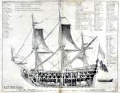 | Details | Henri Sbonski de Passebon | 1690 |
| Antique 17th Century Cutaway View of French Admiral's Flagship |
|
Henri Sbonski de Passebon |
|
| 1690 |
| LOC:55 |
| $750.00 | Henri-Sbonski-de-Passebon | Antique-17th-Century-Cutaway-View-of-French-Admiral-s-Flagship | Antique and scarce 1690 cutaway architectural view of a French Admiral's flagship of 104 cannons. Bernard Quaritch's Catalog No. 229. <sup>1 </sup> attributes the engraving's design to French galley Captain Henri Sbonski de Passebon and the engraving to Claude Randon in de Passebon's "Plans de Plusieurs Batiments de Mer avec leurs Proportions". <br></br>
This highly detailed plate is one of 17 folio-sized antique copperplate engravings in that work which included a similar cutaway of a oared galley. Engraved by Claude Randon, the volume of nautical architecture plates was first published from Marseille where, in the late 17th century the arsenal was home port to the galley service of Louis XIV.<br></br>
<sup>1 </sup> Quaritch, Bernard. "Catalogue of Works on the Fine Arts offered at the net prices affixed, By Bernard Quaritch." London, 1904. http://books.google.com/books?id=i0tFAAAAYAAJ&dq. |
| 4710 |  | Details | Chatelain, Henry | 1695 |
| Carte Generalle du Gouvernement Militaire de France |
|
Chatelain, Henry |
|
| 1695 |
| LOC:0 |
| $250.00 | Chatelain--Henry | Carte-Generalle-du-Gouvernement-Militaire-de-France | Folio-size antique copperplate engraving on chain-laid paper by Chatelain. This scarce decorative historical artifact records the state of France's land and naval forces in 1695.
<BR> </BR>
Contains detailed textual information on the finances and disposition of France's military not found elsewhere and a wealth of images related to those sea forces. It includes views of major naval ports, weapons, emblems, and flags associated with both the regular navy and the galley corps.
<BR> </BR>
There was considerable inter-service rivalry between the sailing navy (vaisseaux) and the galley corps (galeres) of which there were then 40 vessels. The lower left quadrant contains a breakdown by type of the total 665 vaisseaux then in service. The lower right quadrant is dedicated solely to the galley corps, which was then near the peak of its power, listing the number of officers of each rank and the count of each galley type- for instance 1 Galere Reale (Royal Galley, the premier vessel). From the information provided by Chatelain we learn that 6 galleys would have been stationed outside the Mediterranean or Levant: 2 each in Bordeaux, St Malo, and Dunkirk.
<BR> </BR>
Less than 30 years after this engraving was published the Corps des Galeres was disbanded (1748), not able to compete against larger, better armed ships of the line. This sheet provides detailed historical background for collectors of <a rel="nofollow" href= "/MichelotBremondBackground.aspx">Michelot and Bremond</a> charts which were created during the period represented by this plate. Plate 28. |
| 128 |  | Details | Chatelain, Henry | 1695 |
| Gouvernement Militaire de France |
|
Chatelain, Henry |
|
| 1695 |
| LOC:0 |
| $0.00 | Chatelain--Henry | Gouvernement-Militaire-de-France | SOLD
<BR> </BR>
Folio-size antique copperplate engraving on chain-laid paper by Chatelain that records the state of France's land and naval forces in 1695. Contains detailed textual information on the finances and disposition of France's military not found elsewhere and a wealth of images related to those sea forces. Includes views of major naval ports, weapons, emblems, and flags associated with both the regular navy and the galley corps.
<BR> </BR>
There was considerable inter-service rivalry between the sailing navy (vaisseaux) and the galley corps (galeres) of which there were then 40 vessels. The lower left quadrant contains a breakdown by type of the total 665 vaisseaux then in service. The lower right quadrant is dedicated solely to the galley corps, which was then near the peak of its power, listing the number of officers of each rank and the count of each galley type- for instance 1 Galere Reale (Royal Galley, the premier vessel). From the information provided by Chatelain we learn that 6 galleys would have been stationed outside the Mediterranean or Levant: 2 each in Bordeaux, St Malo, and Dunkirk.
<BR> </BR>
Less than 30 years after this engraving was published the Corps des Galeres was disbanded (1748), not able to compete against larger, better armed ships of the line. This sheet provides detailed historical background for collectors of <a rel="nofollow" href= "/MichelotBremondBackground.aspx">Michelot and Bremond</a> charts which were created during the period represented by this plate. Plate 28. |
| 1375 | 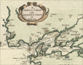 | Details | Moll, Herman | 1695 |
| Antique map of Belle Isle, Brest, in Brittany France |
|
Moll, Herman |
|
| 1695 |
| LOC:7 |
| $200.00 | Moll--Herman | Antique-map-of-Belle-Isle--Brest--in-Brittany-France |
Attractive antique copper-engraved map by Moll of the lower tip of Brittany (Bretagne), France from roughly the Pointe de Corsen, past Pointe de Kermorvan, le Conquet, Brest, and Crozon. This scarce map is titled "The Marquisate and Government of Bell-Isle Divided into its Four Parishes of the Palace, Bangor, Lomaria, and Sauzon."
<br></br>
One unusual feature of this map is the large number of mills the cartographer identifies, perhaps because their high elevation, like that of church steeples, would have provided coastal mariners with navigational reference points ashore. Together Moll's emphasis on features of great height and the rhumb lines with compass rose, suggest the original inspiration for this map is derived from a nautical chart. Verso with map of Belle Isle, France in the Sea of Bretagne. |
| 618 | 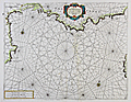 | Details | Coronelli, Vincenzo | 1697 |
| Chart of the Coast of Languedoc and Provence |
|
Coronelli, Vincenzo |
|
| 1697 |
| LOC:58 |
| $950.00 | Coronelli--Vincenzo | Chart-of-the-Coast-of-Languedoc-and-Provence | Antique nautical chart with original hand color covering the southern Mediterranean coast of France including the provinces of Languedoc and Provence. Coverage of this original antique chart includes numerous towns along southern France's Mediterranean coast, including the Cote d'Azure, Monaco, and the western coast of Corsica. Towns noted include Palamos, Roses, Agde, Marseilles, Toulon, Antibe, Freuil, and many more. From the scarce Isolario ( island book ) of Vincenzo Coronelli ca. 1697. <br></br>
Verso with Italian text on two pages and includes two inset views- the first of the town of Avignon, France along the Rhone river, titled "Avignone Già Seggio de Sommi Pontefici". The second inset view, titled "Isole di Ionquieres e Torre di Buc Nel Canale di Martegues" shows the area near the Canal de Martigues in the Bouches-du-Rhône department, nicknamed "The Venice of Provence" because of its canals and maritime features. |
| 315 | 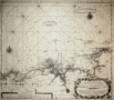 | Details | van Keulen, Gerard | 1698 |
| Nouvelle carte marine croissante en degres d'une partie des cotes maritime de Bretagne |
|
van Keulen, Gerard |
|
| 1698 |
| LOC:0 |
| $375.00 | van-Keulen--Gerard | Nouvelle-carte-marine-croissante-en-degres-d-une-partie-des-cotes-maritime-de-Bretagne | Antique nautical chart of Brittany (Bretagne) from 1698 by Gerard van Keulen, well known Dutch chart maker. Coverage is centered on the coastline, estuary and rivers near Morlaix, France. Goulven, St. Paul de Leon, and Lanion are among the largest towns depicted. Chart contains picturesque details that would have been useful to coastal navigators including villages, churches, windmills, offshore rocks and islands (Les Seit Isles; roche blanche) and navigational aids. Chart is set on a series of rhumb lines with two decorative compass roses. |
| 5264 |  | Details | Bodenher, Gabriel | 1704 |
| Antique bird's-eye view of Cote d'Azur Provence Nice Monaco |
|
Bodenher, Gabriel |
|
| 1704 |
| LOC:77 |
| $350.00 | Bodenher--Gabriel | Antique-bird-s-eye-view-of-Cote-d-Azur-Provence-Nice-Monaco | |
| 5211 |  | Details | Coronelli, Vincenzo | 1706 |
| Rare antique chart of French islands of Sainte-Marguerite and Saint-Honorat |
|
Coronelli, Vincenzo |
|
| 1706 |
| LOC:77 |
| $265.00 | Coronelli--Vincenzo | Rare-antique-chart-of-French-islands-of--Sainte-Marguerite-and-Saint-Honorat | Rare chart of the a portion of the Cote d'Azur and islands of Sainte-Marguerite and Saint-Honorat off the coast of Cannes, (Canet) France near the Cap de Antibes.
<br></br>
This small well-engraved antique chart is from Coronelli's Teatro della Guerra. TEATRO DELLA GUERRA, DIVISO IN XXXXVIII. PARTI, IN CUI SONO ESATTAMENTE DELINEATI, E COMPENDIOSAMENTE DESCRITTI SIN L'ANNO M.DCC. NAPLES, 1706. Page 25.
<br></br>
Vincenzo Maria Coronelli (1650-1718), is considered as one of Italy's most famous and greatest cartographers and cosmographers to the Republic of Venice. |
| 5214 | 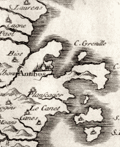 | Details | Coronelli, Vincenzo | 1706 |
| Scarce Italian Map of the French Riviera Cote d'Azur |
|
Coronelli, Vincenzo |
|
| 1706 |
| LOC:77 |
| $265.00 | Coronelli--Vincenzo | Scarce-Italian-Map-of-the-French-Riviera-Cote-d-Azur | Original early eighteenth-century engraved map of the coast of Provence, France at the Cote d'Azur, or French Riviera. Includes the villages of Antibes and Cannes. North is oriented to the upper left.
<br></br>
This small well-engraved antique chart is from Coronelli's Teatro della Guerra. TEATRO DELLA GUERRA, DIVISO IN XXXXVIII. PARTI, IN CUI SONO ESATTAMENTE DELINEATI, E COMPENDIOSAMENTE DESCRITTI SIN L'ANNO M.DCC. NAPLES, 1706. Page 13.
<br></br>
Vincenzo Maria Coronelli (1650-1718), is considered as one of Italy's most famous and greatest cartographers and cosmographers to the Republic of Venice. |
| 5215 | 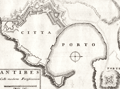 | Details | Coronelli, Vincenzo | 1706 |
| Plan of fortifications at Antibes, France |
|
Coronelli, Vincenzo |
|
| 1706 |
| LOC:77 |
| $265.00 | Coronelli--Vincenzo | Plan-of-fortifications-at-Antibes--France | V. Coronelli's rare antique engraved plan of the port and the Vauban-style fortifications surrounding the city of Antibes, France. Antibes is a town on the French Riviera: the Cote d'Azur. North oriented to the right.
<br></br>
This small well-engraved antique chart is from Coronelli's Teatro della Guerra. TEATRO DELLA GUERRA, DIVISO IN XXXXVIII. PARTI, IN CUI SONO ESATTAMENTE DELINEATI, E COMPENDIOSAMENTE DESCRITTI SIN L'ANNO M.DCC. NAPLES, 1706. Page 25.
<br></br>
Vincenzo Maria Coronelli (1650-1718), is considered as one of Italy's most famous and greatest cartographers and cosmographers to the Republic of Venice. |
| 4744 | 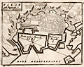 | Details | Coronelli, Vincenzo | 1706 |
| Coronelli's port plan of Toulon, France |
|
Coronelli, Vincenzo |
|
| 1706 |
| LOC:77 |
| $225.00 | Coronelli--Vincenzo | Coronelli-s-port-plan-of-Toulon--France | A fine and rare engraved chart from Coronelli's "Teatro della Guerra" with a plan of Toulon, France along the northern Mediterranean coast. This nice antique engraved chart shows two distinct anchorages for ships: "Porto per i Vascelli de Re" for the King's vessels and "Porto per i Vascelli di Mercanzia" for merchant vessels. The small town of Tolon (Toulon) is shown heavily fortified with then-modern Vauban style walls.
<br></br>
This small well-engraved antique chart is from Coronelli's Teatro della Guerra. TEATRO DELLA GUERRA, DIVISO IN XXXXVIII. PARTI, IN CUI SONO ESATTAMENTE DELINEATI, E COMPENDIOSAMENTE DESCRITTI SIN L'ANNO M.DCC. NAPLES, 1706. (See also our smaller-scale chart of the entire Toulon harbor by Coronelli). Page 8.
<br></br>
Vincenzo Maria Coronelli (1650-1718), is considered as one of Italy's most famous and greatest cartographers and cosmographers to the Republic of Venice. |
| 4745 |  | Details | Coronelli, Vincenzo | 1706 |
| Coronelli's plan of the bay and harbor at Toulon, France |
|
Coronelli, Vincenzo |
|
| 1706 |
| LOC:77 |
| $270.00 | Coronelli--Vincenzo | Coronelli-s-plan-of-the-bay-and-harbor-at-Toulon--France | Attractive antique engraved chart from Coronelli's "Teatro della Guerra" with a harbor chart of Tolon (Toulon), France along the northern Mediterranean coast. Numerous depth soundings crisscross the bay, reflecting several surveys. Little named detail.
<br></br>
This small well-engraved antique chart is from the "Teatro della Guerra." TEATRO DELLA GUERRA, DIVISO IN XXXXVIII. PARTI, IN CUI SONO ESATTAMENTE DELINEATI, E COMPENDIOSAMENTE DESCRITTI SIN L'ANNO M.DCC. NAPLES, 1706. (See also our larger-scale port plan of the town of Toulon by Coronelli). Page 7.
<br></br>
Vincenzo Maria Coronelli (1650-1718), is considered as one of Italy's most famous and greatest cartographers and cosmographers to the Republic of Venice. |
| 5217 | 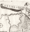 | Details | Coronelli, Vincenzo | 1706 |
| Antique birds-eye view of Antibes, France |
|
Coronelli, Vincenzo |
|
| 1706 |
| LOC:77 |
| $265.00 | Coronelli--Vincenzo | Antique-birds-eye-view-of-Antibes--France | Antique bird's-eye view of Antibes, France. In this scarce early eighteenth-century engraving an angel flies above a fortified port city with a banner that reads: "Antibes Avanti l' ultime Fortificazioni'. That banner flies for Antibes, a village' on the French Riviera or Cote d'Azur, shown with its fortress and harbor.
<br></br>
This small well-engraved antique chart is from Coronelli's Teatro della Guerra. TEATRO DELLA GUERRA, DIVISO IN XXXXVIII. PARTI, IN CUI SONO ESATTAMENTE DELINEATI, E COMPENDIOSAMENTE DESCRITTI SIN L'ANNO M.DCC. NAPLES, 1706.
<br></br>
Vincenzo Maria Coronelli (1650-1718), is considered as one of Italy's most famous and greatest cartographers and cosmographers to the Republic of Venice. |
| 2575 |  | Details | Coronelli, Vincenzo | 1706 |
| Scarce antique map and plan of Marseilles, France |
|
Coronelli, Vincenzo |
|
| 1706 |
| LOC:77 |
| $275.00 | Coronelli--Vincenzo | Scarce-antique-map-and-plan-of-Marseilles--France | Very scarce map of the Bay of Marseille and surrounding area with a birds-eye view of the city of Marseille, France (Marseglia). Marseilles was the home of France's 'Corps de Galleres' or rowing galleys with lateen-rigged sails. The main fleet of French Navy sailing vessels was headquarted in Toulon, France. The two services were combined in 1744.
<br></br>
Shows a very early view of Marseilles predating the construction and fortification of the town's southern side. In 1660, Louis XIV ensured Marseilles would become the premier commercial port of France in the Mediterranean. Louis commissioned significant new fortifications, and was reported to have said “We noticed that the inhabitants of Marseilles were extremely fond of nice fortresses. We wanted to have our own at the entrance to this great port.”
<br></br>
From "La Francia Divisa in XII Prefetture" , a section of Coronelli's multi-volume "Teatro delle citta e porti principali dell'Europa…" Plate 3 with previous plate number 212. Verso blank |
| 5210 |  | Details | Coronelli, Vincenzo | 1706 |
| Coronelli's Forte di Brigancon ed Isole de yeres (Bregancon, Hyeres) |
|
Coronelli, Vincenzo |
|
| 1706 |
| LOC:77 |
| $245.00 | Coronelli--Vincenzo | Coronelli-s-Forte-di-Brigancon-ed-Isole-de-yeres-(Bregancon--Hyeres) | Rare birdseye view of the island of Bregancon, France and the Isles de Hyeres by Coronelli. Today the island of Bregancon, near the French Riviera, is attached to the mainland by a short causeway. Includes the offshore islands of Tilan, Port Cros, Porquerolles and the village of San Margarita. Decorated with drawings of galleys under sail and oars.
<br></br>
This small well-engraved antique chart is from Coronelli's Teatro della Guerra. TEATRO DELLA GUERRA, DIVISO IN XXXXVIII. PARTI, IN CUI SONO ESATTAMENTE DELINEATI, E COMPENDIOSAMENTE DESCRITTI SIN L'ANNO M.DCC. NAPLES, 1706. (See also our smaller-scale chart of the entire Toulon harbor by Coronelli). Page 8.
<br></br>
Vincenzo Maria Coronelli (1650-1718), is considered as one of Italy's most famous and greatest cartographers and cosmographers to the Republic of Venice. |
| 5216 |  | Details | Coronelli, Vincenzo | 1706 |
| Fine elevation view of the town of Orleans, France. |
|
Coronelli, Vincenzo |
|
| 1706 |
| LOC:77 |
| $265.00 | Coronelli--Vincenzo | Fine-elevation-view-of-the-town-of-Orleans--France- | Antique elevation view of the town of Orleans, France along the Loire River. With a fine decorative cartouche dedicating the engraving to Carlo Bernardi.
<br></br>
This small well-engraved antique chart is from Coronelli's Teatro della Guerra. TEATRO DELLA GUERRA, DIVISO IN XXXXVIII. PARTI, IN CUI SONO ESATTAMENTE DELINEATI, E COMPENDIOSAMENTE DESCRITTI SIN L'ANNO M.DCC. NAPLES, 1706.
<br></br>
Vincenzo Maria Coronelli (1650-1718), is considered as one of Italy's most famous and greatest cartographers and cosmographers to the Republic of Venice. |
| 52 |  | Details | Anonymous | 1716 |
| Plan des environs de Dunkerque et Mardick |
|
Anonymous |
|
| 1716 |
| LOC:9 |
| $175.00 | Anonymous | Plan-des-environs-de-Dunkerque-et-Mardick | This antique French map on watermarked, chain-laid paper depicts the environs of Mardick and Dunkirk within 3 years after the demolition of the Dunkirk harbor in 1714. <BR> </BR>
At the end of the War of Spanish Succession England agreed to turn over Dunkirk, which it captured in 1708, to the French. In order to prevent the port's usage as a base for privateers and sea raiders the English demolished the harbor and city walls. This map depicts the French's quick response to the demolition- a new canal near Mardick that re-connected Dunkirk's harbor to the sea. |
| 334 | 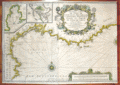 | Details | Michelot and Bremond | 1718 |
| Nouvelle Carte De Cotes De Catalogne, Roussillon, Languedoc, Provence |
|
Michelot and Bremond |
|
| 1718 |
| LOC:58 |
| $1,500.00 | Michelot-and-Bremond | Nouvelle-Carte-De-Cotes-De-Catalogne--Roussillon--Languedoc--Provence | Original antique engraved nautical chart from 1718. Left half of a double-width chart of the Northwestern Mediterranean sea titled: <br> <i>"Nouvelle Carte De Cotes De Catalogne, Roussillon, Languedoc, Provence, D'Italie et Partie De L'Isle De Corce dediee a Monseigneur le Chevalier d'Orleans General de Galeres de France par ses tres Humbles Serviteurs Michelot Hydrographe et Pilot de Galeres du Roy et Bremond Hydrographe du Roy et de la Ville" </i> Dated within an elaborate title cartouche at 1718.
<br></br> Inset port/ harbor plans include: <br>
"Plan du Port de Cette en Languedoc" <br>
"Plan du Port de Cadeques en Catalogne"
<br></br>
This antique nautical chart was produced ca. 1727 by French hydrographer and pilot of the French royal galley "La Reale" <a style="color:#9BAFCB" rel="nofollow" href= "/MichelotBremondBackground.aspx">Henry Michelot</a>. <BR> </BR>
Possibly a later impression as the chart has a small line near bottom left that appears to be the result of a cracked engraving plate. Published by Laurens Bremond from Marseilles, France. |
| 51 |  | Details | Michelot and Bremond | 1720 |
| Plan de la Baye et Rades de Marseille (small scale) |
|
Michelot and Bremond |
|
| 1720 |
| LOC:58 |
| $1,875.00 | Michelot-and-Bremond | Plan-de-la-Baye-et-Rades-de-Marseille-(small-scale) | Antique nautical chart of the Bay of Marseilles, France. Drawn by <a rel="nofollow" href= "/MichelotBremondBackground.aspx">Henri Michelot</a>, pilot of the royal galley for Louis XIV and XV. This large antique sea chart of the Bay of Marseilles would have been useful to coastal navigators such as those with the French Corps de Galeres. Extending from Cap Couronne past Cap Croisete to Morgiou the chart notes local water sources (galleys could only carry enough water for about two weeks), anchorages, and denotes a near-shore passage for the galleys near Cap Croisete: "Passage ordinaire des Galeres". The city of Marseille is shown surrounded by protective walls on three sides. <BR> </BR>
The authors' intimate knowledge of the area is confirmed by their location of several "madragues" around the bay (large anchored fish ponds or seines) that would have posed a threat to any fleet of coastal vessels operating in the area. <BR> </BR>
This chart is of special interest as Marseille the home bases for the galleys ( galère / galères ) of Louis XIV and XV as well as the home port for Michelot and Bremond. In the year this chart was published, 1720, the city of Marseille experienced an outbreak of "la peste", bubonic plague, that killed an estimated 40% of its population. The plague, spread from an arriving merchant ship, was one of the last great outbreaks in Western Europe. Perhaps it is coincidence but the location of both the Infirmerie Vieux and the Infirmerie Vielle in Marseille are indicated.<BR> </BR>
With a large beautifully engraved title cartouche by Starckman featuring Neptune with two overflowing horns-of-plenty. |
| 303 |  | Details | Rigaud, Jacques | 1720 |
| Feste des Galeres dans le Port de Marseille |
|
Rigaud, Jacques |
|
| 1720 |
| LOC:1 |
| $750.00 | Rigaud--Jacques | Feste-des-Galeres-dans-le-Port-de-Marseille | Beautiful early 18th century antique copperplate engraving of the Feste des Galeres (Galère, Fr.) (Galley Festival) held annually in Marseilles, France which was the home port of the Galley Corps during the reign of Louis XIV and Louis XV. At the time this engraving was produced the Galley Corps was in decline but the pomp and grandeur continued. The print shows several dozen galleys, moored stern-first as is the custom in that area, firing a tribute from cannon. The work is full of minute details of the festivities on shore among the onlookers and participants.
<BR> </BR>
Jacques Rigaud (1680-1754) was a French draftsman, artist, and engraver who worked for a time at the Arsenal in Marseille, home to the galley fleet. His first known work is "The View from the Fortress of Toulon" published in 1707. Rigaud was in Marseille during the great plague of 1720 and is well known for his prints of that event as well as for his series of engravings of the royal houses of France. Plate 3. |
| 1137 |  | Details | Henri Sbonski de Passebon | 1720 |
| Rare title page from de Passebon's engravings of nautical architecture |
|
Henri Sbonski de Passebon |
|
| 1720 |
| LOC:9 |
| $1,850.00 | Henri-Sbonski-de-Passebon | Rare-title-page-from-de-Passebon-s-engravings-of-nautical-architecture | Stunningly beautiful hand-colored engraved title page from Henri Sbonski de Passebon's ca. 1720
<a href="
https://www.rarecharts.com/SbonskiPassebonBackground.aspx" target="_blank">atlas of Mediterranean naval architecture</a>.
<br></br>
Engraved by Simonneau, drawn by Berey. |
| 46 |  | Details | Michelot and Bremond | 1727 |
| Plan de la Baye et Rades de Marseille LS |
|
Michelot and Bremond |
|
| 1727 |
| LOC:4 |
| $0.00 | Michelot-and-Bremond | Plan-de-la-Baye-et-Rades-de-Marseille-LS | SOLD<br></br>
Antique, original copperplate portulan-style coastal chart / plan of the Bay of Marseille and nearby islands. Coverage includes coastal France from Cap Couronne to Port Estat. Marseille shown with fortifications as they existed in the early 18th century.<BR> </BR>
Numerous soundings and marked anchorages on this antique nautical chart would have been useful to galley pilots and other mariners calling at Marseille. Single compass rose with radiating rhumb lines and fleur de lis indicating north. <a rel="nofollow" href= "/MichelotBremondBackground.aspx">Henry Michelot's</a> chart of Marseille was often copied by others such as Kitchin well into the late 1700's.<BR> </BR>
This chart is of special interest as Marseille was the chief base for the galleys (galères) of Louis XIV and XV as well as the home port for Michelot and Bremond. Also note that just seven year earlier, in 1720, the city of Marseilles had been subject to an outbreak of "la peste", bubonic plague that killed an estimated 40% of its population. The plague, spread from an arriving merchant ship was one of the last great outbreaks in Europe. |
| 254 | 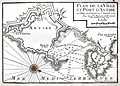 | Details | Michelot and Bremond | 1727 |
| Plan de la Ville et Port d'Antibe (Antibes) |
|
Michelot and Bremond |
|
| 1727 |
| LOC:4 |
| $300.00 | Michelot-and-Bremond | Plan-de-la-Ville-et-Port-d-Antibe-(Antibes) | Highly detailed, engraved port plan of Antibes, France on the French Riviera or Cote d'Azur. Highlighted by a colored compass rose, this old antique chart / plan shows the city and fort of Antibes both surrounded by defensive walls. Numerous soundings, underwater hazards, and anchorages are noted in and near Antibes harbor. This nautical chart was produced in 1727 by French hydrographers and galley (galère, Fr.) pilot <a style="color:#9BAFCB" rel="nofollow" href= "/MichelotBremondBackground.aspx">Henry Michelot</a> and Laurens Bremond.
<BR> </BR>
A note in the title cartouche states that the chart is based on information that was current as of 1720. The distance scale is in toises which was about 1.95 meters before 1812. |
| 4708 | 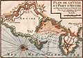 | Details | Michelot and Bremond | 1727 |
| Plan de la Ville et Port d'Antibe (Antibes) |
|
Michelot and Bremond |
|
| 1727 |
| LOC:13 |
| $350.00 | Michelot-and-Bremond | Plan-de-la-Ville-et-Port-d-Antibe-(Antibes) | Highly detailed, engraved port plan of Antibes, France on the French Riviera or Cote d'Azur, based on information that was current as of 1720. Highlighted by a colored compass rose oriented with north to bottom right, this old antique chart / plan shows Antibes surrounded by Vauban-style defensive walls. Key noted features include "le Chateau", land and sea entrances (ports), le mole or jetty, the Fort d'Antibes and a beach leading to Nice - "Plage qui conduit a Nice."
<BR> </BR>
Numerous soundings, underwater hazards, and anchorages are noted in and near Antibes harbor. This nautical chart was produced in 1727 by French hydrographers and galley (galère, Fr.) pilot Henry Michelot and Laurens Bremond.
<BR> </BR>
The distance scale is in toises which was about 1.95 meters before 1812. |
| 100 | 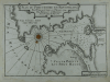 | Details | Michelot and Bremond | 1727 |
| Plan du Port du Portvendre en Roussillon |
|
Michelot and Bremond |
|
| 1727 |
| LOC:4 |
| $300.00 | Michelot-and-Bremond | Plan-du-Port-du-Portvendre-en-Roussillon | Interesting large-scale, black and white copperplate antique nautical chart / plan of Portvendre (Port-Vendres), France with a carefully colored compass rose. This antique chart is one of 37 port plans published by <a rel="nofollow" href= "/MichelotBremondBackground.aspx">Henry Michelot and Laurens Bremond</a> ca. 1730 in their atlas of small scale Mediterranean ports: "Recueil de Plusieurs Plans de Ports et Rades de la Mer Mediterranée" .
<BR> </BR>
Notations are made on both sides of the bay warning that the surrounding land is high. It must have been a welcome sight when a navigator finally spied the beach near the harbor where a galley (galère) could land. Along with two forts, the few noted points of interest include a water source, a chapel, and a few stores. |
| 332 | 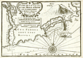 | Details | Michelot and Bremond | 1727 |
| Plan de la Ville et du Mole d'Agde in Languedoc |
|
Michelot and Bremond |
|
| 1727 |
| LOC:4 |
| $375.00 | Michelot-and-Bremond | Plan-de-la-Ville-et-du-Mole-d-Agde-in-Languedoc | Small antique nautical chart / plan depicts the small walled village of Agde, France along the lower portion of the Riviere de l'Eraux (Hérault River) with two bridges. At top left is the junction of that river with the Canal Royal (Canal du Midi) and l'Ecluse (locks), well known because of their unusual round shape. Other feature include Mont d'Adge, Fort de Brescon offshore of "le Mole" (a breakwater or jetty), la Conque, and Plage de Tau (Thau).<BR> </BR>
This antique nautical chart was produced ca. 1730 by French hydrographer and pilot of the French royal galley "La Reale" <a style="color:#9BAFCB" rel="nofollow" href= "/MichelotBremondBackground.aspx">Henry Michelot</a>. The port plan was one of 37 original plans published in Marseilles by Michelot and Laurens Bremond in a volume titled "Recueil de Plusieurs Plans de Ports et Rades de la Mer Mediterranée." Later in the 18th century the plans were copied and reprinted by Roux, Allezard, Kitchin and others. |
| 331 | 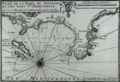 | Details | Michelot and Bremond | 1727 |
| Plan de la Rade du Gourjan et des Isles Ste. Marguerite |
|
Michelot and Bremond |
|
| 1727 |
| LOC:4 |
| $425.00 | Michelot-and-Bremond | Plan-de-la-Rade-du-Gourjan-et-des-Isles-Ste--Marguerite | Antique copperplate-engraved nautical chart / plan of the islands, bay, and beaches between Cane (Cannes) and Antibe, France in the Cote d'Azur region of the French Riviera. Islands noted offshore by Michelot include Isle St. Honora (Saint-Honorat ) and Île Sainte-Marguerite which is one of the locations where the "man in the Iron Mask" is known to have been jailed. Other features are Pointe de la Foucade (Fourcade) Cap de la Garoupe, tours de la Croisette on (Cap de la Croisette) and two beaches: plage du pilon, and plage qui conduit a Nice.<BR> </BR>
This antique chart / plan was produced ca. 1730 by French hydrographer and pilot of the French royal galley "La Reale" <a style="color:#9BAFCB" rel="nofollow" href= "/MichelotBremondBackground.aspx">Henry Michelot</a>. The port plan was one of 37 original plans published in Marseilles by Michelot and Laurens Bremond in a volume titled "Recueil de Plusieurs Plans de Ports et Rades de la Mer Mediterranée." Later in the 18th century the plans were copied and reprinted by Roux, Allezard, Kitchin and others. |
| 328 | 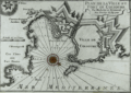 | Details | Michelot and Bremond | 1728 |
| Plan de la Ville et Port de Colioure |
|
Michelot and Bremond |
|
| 1728 |
| LOC:4 |
| $300.00 | Michelot-and-Bremond | Plan-de-la-Ville-et-Port-de-Colioure | Fine antique print with a depiction and plan of the harbor and village of Colioure (Collioure), in Southern France near the border of Spain. Features include Fort Saint-Elme, Convent de Jacobins, the Chateau Royal and l'Ermitage. Thick Vauban-designed defensive walls are shown surrounding the Chateau and village.<BR> </BR>
This nautical chart / plan was produced ca. 1730 by French hydrographer and pilot of the French royal galley "La Reale" <a style="color:#9BAFCB" rel="nofollow" href= "/MichelotBremondBackground.aspx">Henry Michelot</a>. The port plan was one of 37 original plans published in Marseilles by Michelot and Laurens Bremond in a volume titled "Recueil de Plusieurs Plans de Ports et Rades de la Mer Mediterranée." Later in the 18th century the plans were copied and reprinted by Roux, Allezard, Kitchin and others. |
| 66 |  | Details | Dumont, Jean | 1729 |
| Plan de Toulon |
|
Dumont, Jean |
|
| 1729 |
| LOC:0 |
| $0.00 | Dumont--Jean | Plan-de-Toulon | SOLD<br></br>
Large detailed antique map / plan shows the siege of Toulon in 1707. Focus is on the fortifications, disposition of troops, and lines of fire. Depiction of the walled, moated, city of Toulon with the old port, new port and all associated forts and emplacements. With a bird's eye inset of Toulon in the lower left corner. |
| 101 | 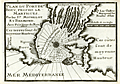 | Details | Michelot and Bremond | 1730 |
| Plan du Port de Bouc |
|
Michelot and Bremond |
|
| 1730 |
| LOC:4 |
| $300.00 | Michelot-and-Bremond | Plan-du-Port-de-Bouc | Antique copperplate nautical chart / port plan of the entrance to the harbor at Port-de-Bouc near Martigues, France produced by French hydrographer and galley pilot Henry Michelot and Laurens Bremond in 1730 . Along with many soundings and navigation hazards the features that Michelot deemed important and referenced by name include a "Pigeonnier", the beach "Plage de Fos", a tower "Tour de Bouc", and numerous "Bordigues" or fish weirs.
<BR> </BR>
Michelot describes Bouc harbor in the English translation of his book of sailing directions published in 1715 - "The Mediterranean Pilot". Michelot's self-confidence in his superior knowledge of the region is unmistakable: <br><div class="indenttextblock">"The mouth is very narrow being only 150 fathoms over; on the starboard point as you go in there is a fortress with a square tower in the middle, of white stone which is seen a great way off; it stands at a low point of an island, which is only separated from the main land by a small rivolet, The Dutch and some authors set down the entrance of this port in their sea-mapps to the eastward of this island where the tower of Bouc is; which shows they have never used this coast, no more than the author of the little Flambeau, printed at Harve de Grace."</div> |
| 1020 |  | Details | Michelot and Bremond | 1730 |
| 1730 Plan of Port-de-Bouc, near Martigues, France |
|
Michelot and Bremond |
|
| 1730 |
| LOC:50 |
| $320.00 | Michelot-and-Bremond | 1730-Plan-of-Port-de-Bouc--near-Martigues--France | Antique copperplate nautical port plan of the entrance to the harbor at Port-de-Bouc near Martigues, France produced by French hydrographer and galley pilot Henry Michelot and hydrographer Laurens Bremond in 1730 . Colored compass rose at center with rhumb lines and numerous soundings.
<br></br>
Along with soundings and navigation hazards the features that Michelot deemed important near Port-de-Bouc and referenced by name include a "Pigeonnier", the beach "Plage de Fos", a tower and fortress "Tour de Bouc", and numerous "Bordigues" or fish weirs. |
| 459 |  | Details | Diderot, Denis | 1730 |
| Marine Pavillons (Flags) |
|
Diderot, Denis |
|
| 1730 |
| LOC:0 |
| $0.00 | Diderot--Denis | Marine-Pavillons-(Flags) | SOLD
<BR> </BR>
Very decorative pair of 18th century copper-plate engraved prints depicting naval flags, pennants, and ensigns from across the world. Several flags contains the coat-of-arms of a royal family. Archivally matted, and ready for framing. With matting, each engraving measures approximately 14" W x 19" H. <BR> </BR>
A scarce and colorful grouping. Source: Diderot & D'Alembert. L'Encyclopédie. Plate 18 and Plate 19. |
| 1003 |  | Details | Diderot, Denis | 1730 |
| Marine Pavillons (Flags) Plate XIX |
|
Diderot, Denis |
|
| 1730 |
| LOC:0 |
| $0.00 | Diderot--Denis | Marine-Pavillons-(Flags)-Plate-XIX | SOLD
<BR> </BR>
Desirable and very decorative early 18th century copper-plate engraved print depicting naval flags, pennants, and ensigns from across the world. Several flags contains the coat-of-arms of a royal family. Two of the more interesting flags include one with the lion of St. Marks, presumably from Venice and another red flag with an an arm wielding a curved scimitar, possibly related to Hamburg.
<BR> </BR>
Published by Diderot & D'Alembert in L'Encyclopédie. Plate 19. |
| 1004 |  | Details | Diderot, Denis | 1730 |
| Marine Pavillons (Flags) Plate XX |
|
Diderot, Denis |
|
| 1730 |
| LOC:1 |
| $225.00 | Diderot--Denis | Marine-Pavillons-(Flags)-Plate-XX | Extremely decorative early 18th century hand-colored, engraved print depicting naval flags, pennants, and ensigns from across the world. Several flags contains the coat-of-arms of a royal family. Many flags contain a crescent moon, indicative of the Ottoman Empire. Plate 20. <BR> </BR>
Published by Diderot & D'Alembert in L'Encyclopédie. |
| 327 |  | Details | Michelot and Bremond | 1730 |
| Plan de la Baye de Poyance et de Celle d'Alcudia |
|
Michelot and Bremond |
|
| 1730 |
| LOC:0 |
| $0.00 | Michelot-and-Bremond | Plan-de-la-Baye-de-Poyance-et-de-Celle-d-Alcudia | SOLD<BR> </BR>
Scarce antique chart / plan of the Bays of Poyance (Pollensa or Pollenca) and Alcudia with Cap Fromentel (Formentor) on the island of Mallorca (Majorca). The villages of Alcudia and Poyance are each depicted as perched atop a hill and the surrounding area is protected by several guard towers which also would have served as navigational aids to the coastwise navigator. Composition of beaches, anchorages, and soundings are noted along with a water source. These details would have been of special interest to passing galleys.<BR> </BR>
This plan was produced ca. 1730 by French hydrographer and pilot of the French royal galley "La Reale" <a style="color:#9BAFCB" rel="nofollow" href= "/MichelotBremondBackground.aspx">Henry Michelot</a>. The port plan was one of 37 original plans published in Marseilles by Michelot and Laurens Bremond in a volume titled "Recueil de Plusieurs Plans de Ports et Rades de la Mer Mediterranée." Later in the 18th century the plans were copied and reprinted by Roux, Allezard, Kitchin and others. |
| 592 |  | Details | de Fer, Nicolas | 1730 |
| Le Roussillon |
|
de Fer, Nicolas |
|
| 1730 |
| LOC:0 |
| $1,100.00 | de-Fer--Nicolas | Le-Roussillon | Beautiful, old, antique map of the French historical county of Roussillion and the southern French Mediterranean coastline ca. 1730 . Today the area comprises the French department of Pyrenees-Orientales. With 7 inset plans of towns surrounded by walled Vauban-style fortifications: Perpignan; Ville-Franche; Mont-Louis; Belle-Garde; Collioure; Puicerda; Roses. Coverage includes northern Catalonia (Catalunya ). Interestingly an inset shows the town of Roses, Spain as part of Roussillon.
<br></br>
A compass rose and numerous galleys and square-rigged ships at battle fill the Mediterranean. Extremely colorful, decorative and interesting.
<br></br>
This scarce antique map of Roussillon was produced ca. 1727 by Nicholas de Fer, Geographer to Louis XIV. Published from Paris by G. Danet "sur le Pont N. Dame sur la Sphere Royale". Verso blank. |
| 1056 | 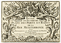 | Details | Michelot and Bremond | 1730 |
| Michelot Title Page - Recueil de Plusieurs Plans des Ports et Rades (2) |
|
Michelot and Bremond |
|
| 1730 |
| LOC:1 |
| $215.00 | Michelot-and-Bremond | Michelot-Title-Page---Recueil-de-Plusieurs-Plans-des-Ports-et-Rades-(2) | Title page to "Recueil de Plusieurs Plans des Ports et Rades de la Mer Mediterranee", <a rel="nofollow" href= "/MichelotBremondBackground.aspx">Henry Michelot and Laurens Bremond's</a> quarto-sized atlas of Mediterranean ports and harbors published between 1727 and 1730. This elaborately engraved title page is very rarely found alone, usually only as one of the 38 plates in a copy of the complete Michelot and Bremond atlas.
<BR> </BR>
Interesting note is that on the bottom neatline, previously engraved wording has been hastily covered over before printing, with just top and bottom of characters still visible. |
| 216 |  | Details | Michelot and Bremond | 1730 |
| Title Page - Recueil de Plusieurs Plans des Ports et Rades |
|
Michelot and Bremond |
|
| 1730 |
| LOC:4 |
| $475.00 | Michelot-and-Bremond | Title-Page---Recueil-de-Plusieurs-Plans-des-Ports-et-Rades | Title page to "Recueil de Plusieurs Plans des Ports et Rades de la Mer Mediterranee", <a rel="nofollow" href= "/MichelotBremondBackground.aspx">Henry Michelot and Laurens Bremond's</a> quarto-sized atlas of Mediterranean ports and harbors published between 1727 and 1730. This elaborately engraved title page is very rarely found alone, usually only as one of the 38 plates in a copy of the complete Michelot and Bremond atlas.
<BR> </BR>
Interesting note is that on the bottom neat line, previously engraved wording has been hastily covered over before printing, with just top and bottom of characters still visible. |
| 329 | 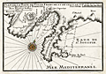 | Details | Michelot and Bremond | 1730 |
| Plan de la Baye de Villefranche et de Celle de St. Souspir |
|
Michelot and Bremond |
|
| 1730 |
| LOC:4 |
| $375.00 | Michelot-and-Bremond | Plan-de-la-Baye-de-Villefranche-et-de-Celle-de-St--Souspir | Interesting antique chart / plan of the bay, harbor and walled city of Villefranche-sur-Mer, France in the Cote d'Azur region of the French Riviera. Numerous soundings and anchorages are noted in the bay which is one of the deepest natural harbors in the Mediterranean. Other depicted features include the Ruines du Chateau de Nice, the old harbor "la Darce", Fort Mont Alban, Tour de Boze, Pointe de Mala Langue (now Cap Ferrat) , Ruines de Fort St. Souspir, and the villages of St. Michel and Heze (Èze). <BR> </BR>
This antique nautical plan was produced ca. 1730 by French hydrographer and pilot of the French royal galley "La Reale" <a style="color:#9BAFCB" rel="nofollow" href= "/MichelotBremondBackground.aspx">Henry Michelot</a>. The port plan was one of 37 original plans published in Marseilles by Michelot and Laurens Bremond in a volume titled "Recueil de Plusieurs Plans de Ports et Rades de la Mer Mediterranée." Later in the 18th century the plans were copied and reprinted by Roux, Allezard, Kitchin and others. |
| 330 | 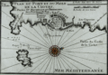 | Details | Michelot and Bremond | 1730 |
| Plan du Port et du Mole de la Ciotat |
|
Michelot and Bremond |
|
| 1730 |
| LOC:4 |
| $355.00 | Michelot-and-Bremond | Plan-du-Port-et-du-Mole-de-la-Ciotat | Antique copper-plate engraved nautical chart / plan of the area surrounding la Ciotat, France in the Cote d'Azur region of the French Riviera. Named features noted by Michelot in this antique chart include Cap Canaille, Cap de l'Aigle, the fountaine du prat; port, mole (jetty or breakwater), and fort of la Ciotat; les Capucins, and Pointe des Moulins.<BR> </BR>
This plan was produced ca. 1730 by French hydrographer and pilot of the French royal galley "La Reale" <a style="color:#9BAFCB" rel="nofollow" href= "/MichelotBremondBackground.aspx">Henry Michelot</a>. The port plan was one of 37 original plans published in Marseilles by Michelot and Laurens Bremond in a volume titled "Recueil de Plusieurs Plans de Ports et Rades de la Mer Mediterranée." Later in the 18th century the plans were copied and reprinted by Roux, Allezard, Kitchin and others. |
| 1430 | 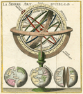 | Details | Dufresnoy, Lenglet | 1736 |
| Terrestrial Armillary Sphere- A fine antique engraving. |
|
Dufresnoy, Lenglet |
|
| 1736 |
| LOC:41 |
| $90.00 | Dufresnoy--Lenglet | Terrestrial-Armillary-Sphere--A-fine-antique-engraving- | Very decorative copper-plate engraved print from 1736 containing an image of a terrestrial armillary sphere. An armillary sphere is a model of an astronomical object, including potentially the earth. They include graduated rings representing circles on a celestial sphere, such as the meridian, the poles, equator, ecliptic horizon, and the tropics.
<br></br>
Beneath the armillary sphere are three representations of the terrestrial globe as seen as both a whole sphere and divided into two hemispheres. In all, a very attractive and interesting antique enraving. Tome 1. Page 158.
<br></br>
From a work titled: "Methode pour Etudier la Geographie ou l'on donne une description exacte de l'Universe…" published by Rollin and de Bure, Quay des Augustins, du cote du Pont St. Michel. Published from Paris, France with the royal privilege in 1736. |
| 160 | 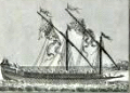 | Details | Pluche, N.A. | 1736 |
| A Galley on Her Oars |
|
Pluche, N.A. |
|
| 1736 |
| LOC:0 |
| $75.00 | Pluche--N-A- | A-Galley-on-Her-Oars | Small copperplate antique engraving by Pluche showing a galley (galère) with 27 oars per side with the sails furled as it heads into harbor. Large banners attached to the antennae drift in the breeze as several sailors work on the rigging in the forward part of the ship. Plate 15. Vol 3. Page 132. |
| 161 | 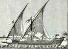 | Details | Pluche, N.A. | 1736 |
| A Galley under Sail |
|
Pluche, N.A. |
|
| 1736 |
| LOC:0 |
| $75.00 | Pluche--N-A- | A-Galley-under-Sail | Small copperplate antique engraving by Pluche showing a galley (Galère, Fr.) with 27 oars per side under sails with the oars stowed. The ships boat is clearly visible as is a cloud of smoke which may originate from the cooking 'galley'. Plate 14. Vol 3. Page 132. |
| 154 |  | Details | de la Jaisse, Pierre | 1736 |
| St. Tropez |
|
de la Jaisse, Pierre |
|
| 1736 |
| LOC:0 |
| $0.00 | de-la-Jaisse--Pierre | St--Tropez | SOLD<br></br>
Scarce antique plan of this Cote d'Azur vacation hot spot from the unusual military and maritime port atlas produce by French author Pierre Lemau de la Jaisse in 1736. Front contains a copperplate-engraved circular view of St. Tropez and an armorial shield of "Saint Tropez" inset into a woodblock-engraved frame of standardized design that is repeated across the series. <BR> </BR>
Verso contains information about the "Frontiere Ancienne" Isle Ste. Marguerite, it longitude and latitude, and a brief description of the surrounding fortifications including a mention of three forts: Fortin, d'Arragon, and Royal. |
| 156 |  | Details | de la Jaisse, Pierre | 1736 |
| La Rochelle |
|
de la Jaisse, Pierre |
|
| 1736 |
| LOC:0 |
| $0.00 | de-la-Jaisse--Pierre | La-Rochelle | Scarce antique plan of La Rochelle from the military and maritime port atlas produced by French author Pierre Lemau de la Jaisse in 1736. Front contains a copperplate-engraved circular view of Brest harbor and fortifications and an armorial shield both inset into a woodblock-engraved frame of standardized design that is repeated across the series. <BR> </BR>
Verso contains a very brief history about the "Frontiere Moderne" village of Rochefort, its longitude and latitude, and a list of the major military and government officials including the Capitaine de Vaisseau and Capitaine de Port- M. de Bailliveau. |
| 155 |  | Details | de la Jaisse, Pierre | 1736 |
| Brest |
|
de la Jaisse, Pierre |
|
| 1736 |
| LOC:0 |
| | de-la-Jaisse--Pierre | Brest | SOLD
<br></br>
Scarce plan of Brest on the Bay of Biscay from the antique military and maritime port atlas produce by French author Pierre Lemau de la Jaisse in 1736. Front contains a copperplate-engraved circular view of Brest harbor and fortifications and an armorial shield inset into a woodblock-engraved frame of standardized design that is repeated across the series. <BR> </BR>
Verso contains information about the "Frontiere Ancienne" town "Port Louis", longitude and latitude, and a list of the major military and government officials. |
| 746 | 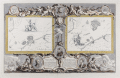 | Details | Pine, John | 1739 |
| John Pine Armada Engraving Plates IX and X |
|
Pine, John |
|
| 1739 |
| LOC:0 |
| $1,250.00 | Pine--John | John-Pine-Armada-Engraving-Plates-IX-and-X | Stunning, beautifully engraved and deftly hand-colored intaglio engraving commemorating the defeat of the "Invincible Armada" of Spain by Britain in 1588 during the reign of Elizabeth I. This original antique copper-plate engraving was engraved and published by John Pine of London in 1739 in his folio volume titled "The Tapestry Hangings of the House of Lords, Representing the Several Engagements between the English and Spanish Fleets in the memorable year MDLXXXVIII".
<br></br>
Two inset charts depict the actions of August 6 - 9, 1588 when the Spanish Armada, anchored off Calais, France was attacked by eight English fireships and on the following day was attacked off Gravelines, France. Those two days are considered the decisive points that lead to the ultimate destruction of the Spanish Armada.
<br></br>
Two attributes of Pine's 'Armada" engravings make them very special. First, the great detail, elaborate design and brilliant execution of the work has led these to be considered by many to be among the very finest engraved works of the 18th century. Second, the printing process used a multiple plate printing process that is rarely encountered. The two inset charts (IX and X) were each printed separately from the background in a beautiful blue ink. The separate plate-marks of the two inset charts are clearly visible and noticeable to the touch.
<br></br>
At bottom center reads: "Published by John Pine, June 24, 1739 according to an Act of Parliament". |
| 1040 |  | Details | Homann Heirs | 1743 |
| Carte d' Artois et des Environs |
|
Homann Heirs |
|
| 1743 |
| LOC:0 |
| $250.00 | Homann-Heirs | Carte-d--Artois-et-des-Environs | Decorative antique map of France covers the Duchy of Artois from Dunkerque to Abbeville and inland to Lille, Douai and Cambrai. Decorated with a very attractive uncolored title cartouche.
<br></br>
Published by the firm Homann Heirs. Homann Heirs (also "Homannianis Heredibus" or "Homann Erben" or "Heritiers de Homann") was a company established after the death of German cartographer J.B. Homann to carry on the publishing business of the firm he started in the early 1700's. The designation "Homann Heirs" appears on maps published by that successor firm from about 1730 to 1848. |
| 6777 | 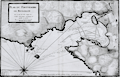 | Details | Ayrouard, Jacques | 1746 |
| Plan du Portvendre en Rousillon |
|
Ayrouard, Jacques |
|
| 1746 |
| LOC:8 |
| $375.00 | Ayrouard--Jacques | Plan-du-Portvendre-en-Rousillon | Fine original hydrographic port and harbor chart for Portvendre (Port-Vendres), France by Jacques Ayrouard (Marseilles ca. 1732- 1746). This antique copperplate engraving shows the town of Port-Vendres as it was in 1733 with the adjacent topography in great detail. Noted features include the Devil's Tower- "Tour de Diable", Fort de la Mauresque or "le Fort et le Fanal", "la Redoutte", the "Cote qui va a Cadequie" and "Cote qui va a Colioure., "le bourg", two other towers- "la masane" and "St. Elme", and the "maison du gouvernment". North is oriented to the bottom of the chart.
<br></br>
Ayrouard makes extensive use of depth soundings and variegated stippling for rough depth contour intervals and has laid down sight bearing lines from the above towers to other fixed objects to help mariners navigate the challenging entrance to Port-Vendres.
<br></br>
<div id="0" align="center">
<a title=""></a>
<img id="6777" src="/ZoomifyImages/SC_6777/SC_6777_detail_1.jpg" alt="Plan du Portvendre en Rousillon. A hydrographic port plan for Port-Vendres, Frances by Jacques Ayrouard. 1746." width="340"/> <br><br> <font size="-2">View of Port-Vendres, Frances by Ayrouard, 1746.</font>
</div><br>
Sourced from Ayrouard's scarce sea atlas: "Recueil de Plusiers Plans des Ports et Rades et de Quelque Cartes Particulieres de la Mer Méditerranée." Beautifully engraved by Louis Corne.
<br></br>
Ayrouard was a pilot of the French royal galley, the Reale, based in Marseille, France. The much larger size (18"x11") and extensively shaded topography in this plan are distinctive characteristics of Ayrouard's nautical port plans. Plate 68. <BR> </BR> |
| 63 | 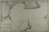 | Details | Ayrouard, Jacques | 1746 |
| Plan du Port d'Antibe |
|
Ayrouard, Jacques |
|
| 1746 |
| LOC:8 |
| $450.00 | Ayrouard--Jacques | Plan-du-Port-d-Antibe | Antique port / harbor plan of the northwest portion of the fortress at Antibe, France and the harbor including Fort Quare opposite to the north. Much detail about the Antibes breakwater and mole. Small inset in upper right containing a profile of the mole and fortifications as seen from the sea. This chart is by Jacques Ayrouard (Marseilles ca. 1732- 1746) from a scarce atlas titled: "Recueil de Plusiers Plans des Ports et Rades et de Quelque Cartes Particulieres de la Mer Méditerranée". <BR> </BR>
Little information exists on Ayrouard's background but like <a rel="nofollow" href= "/MichelotBremondBackground.aspx">Henry Michelot</a>, Ayrouard was a pilot of the French royal galley, the Reale, based in Marseille, France. However, Ayrouard's port plans and rare sea charts are very different from Michelot's earlier works. The much larger size (18"x11") and extensively shaded topography seen in this plan of Antibe are distinctive characteristics of Ayrouard's plans. Engraved by Louis Corne. Plate 15. <BR> </BR> |
| 62 | 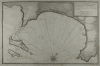 | Details | Ayrouard, Jacques | 1746 |
| Plan de La Baye du Gourien et des Isles St. Marguerite |
|
Ayrouard, Jacques |
|
| 1746 |
| LOC:8 |
| $390.00 | Ayrouard--Jacques | Plan-de-La-Baye-du-Gourien-et-des-Isles-St--Marguerite | Scarce, antique nautical harbor plan / chart of the village of Cane' (Cannes) France on the French Riviera with the offshore Lerins Islands. On the largest of these islands, Ile Sainte-Marguerite, the Man in the Iron Mask was held prisoner during 1687-1698. This antique chart of the area around Cannes is by Jacques Ayrouard (Marseilles ca. 1732- 1746) from a scarce atlas titled: "Recueil de Plusiers Plans des Ports et Rades et de Quelque Cartes Particulieres de la Mer Méditerranée". <BR> </BR>
Interior areas shown with little structural detail, but do contain significant shading and hachuring to convey elevation details. Little information exists on Ayrouard's background but like Henry Michelot before him, Ayrouard was a pilot of the French royal galley, the Reale, based in Marseille. However, Ayrouard's port plans are very different from Michelot's earlier works. The much larger size (18"x11") and extensively shaded topography are distinctive characteristics of Ayrouard's charts. <BR> </BR>
On chain-laid paper. Large compass rose with fleur-de-lis. Plate 13. |
| 1473 |  | Details | Ayrouard, Jacques | 1746 |
| Scarce antique port plan of Port-de-Bouc, France |
|
Ayrouard, Jacques |
|
| 1746 |
| LOC:8 |
| $300.00 | Ayrouard--Jacques | Scarce-antique-port-plan-of-Port-de-Bouc--France | Scarce antique French port chart for the town of Port-de-Bouc, France made by Jacques Ayrouard, at Marseilles, in 1746. No. 35.
<br></br>
In the attribution at bottom, Ayrouard is described as "Pilote Real", or pilot of la Reale, the flagship of the French galley corps with a total complement of about 550 including 360 oarsmen and 100 soldiers. In their <i>Dictionnaire de la Marine</i> from 1702 Covens and Mortier explain: <div class="indenttextblock">"(Réale) is the name of the main galley of an independent kingdom, not of a tributary kingdom annexed to a greater one. The Réale, in France, is reserved for the general of the galleys and flies the royal ensign which distinguishes it from the others. This ensign is square in shape and red in colour, with golden fleurs-de-lys." <a href="http://www.ulmo.net/bateaux/reale/dico02.jpg" target="_blank"> (Internet)</a> </div>
Ayrouard was likely one of the last such pilots as the French Corps des Galeres was disbanded in 1748 and incorporated into the regular French sailing navy. |
| 1328 | 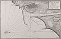 | Details | Ayrouard, Jacques | 1746 |
| Antique plan of the port of Cette, France (Sete) |
|
Ayrouard, Jacques |
|
| 1746 |
| LOC:8 |
| $600.00 | Ayrouard--Jacques | Antique-plan-of-the-port-of-Cette--France-(Sete) | Antique French Mediterranean port plan or chart for the town of <b>Sète, France</b> (Cette) in the southeast French region of Occitanie. This old port plan by Jacques Ayrouard (Marseilles ca. 1732- 1746) depicts the small port of Sète in 1733, likely on an earlier visit by Ayrouard. Of particular interest is that Sète is and was the Mediterranean terminus for the Canal Royal de Languedoc ( now the <b>Canal du Midi</b> ), opened in 1681. Shows the protective outer môle or jetty with a walkway and an inner jetty of rock. Wharves line docks where offshore sailing vessels would have had their cargos unloaded and trans-shipped through the canal in smaller shallow-draft barges. In the early 18th century French galleys may have traveled through the canal between their base in Marseilles and Bordeaux, St. Malo or Dunkirk. (Source: Chatelain, Henry. "Carte Generalle du Gouvernement Militaire de France")
<br></br>
The antique chart was published from Marseilles, France in a scarce atlas titled: "Recueil de Plusiers Plans des Ports et Rades et de Quelque Cartes Particulieres de la Mer Mediterranee".
<br></br>
In the attribution Ayrouard is described as "Pilot Real" or pilot of la Reale, the flagship of the French galley corps with a total complement of about 550 including 360 oarsmen and 100 soldiers. In their <i>Dictionnaire de la Marine</i> from 1702 Covens and Mortier explain: <div class="indenttextblock">"(Réale) is the name of the main galley of an independent kingdom, not of a tributary kingdom annexed to a greater one. The Réale, in France, is reserved for the general of the galleys and flies the royal ensign which distinguishes it from the others. This ensign is square in shape and red in colour, with golden fleurs-de-lys." <a href="http://www.ulmo.net/bateaux/reale/dico02.jpg" target="_blank"> (Internet)</a> </div> |
| 4864 | 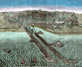 | Details | Vivarez, Henry Emile | 1750 |
| View of Dunkirk |
|
Vivarez, Henry Emile |
|
| 1750 |
| LOC:88 |
| $195.00 | Vivarez--Henry-Emile | View-of-Dunkirk | Original, antique vue d-optique of Dunkerque (Dunkirk), France. Shows long piers protecting a channel into Dunkirk harbor. From Choix de vues d'optique des XVIIIe et XIXe siècles. Tome 4. By Henry Emile Vivarez. |
| 471 |  | Details | Anonymous | 1750 |
| La Boussole |
|
Anonymous |
|
| 1750 |
| LOC:1 |
| $55.00 | Anonymous | La-Boussole | Mid 18th century hand-colored copperplate engraving of a ship's compass mounted in a binnacle. Detailed views of the compass card and compass needle. |
| 3634 | 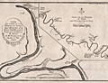 | Details | Buache, Philippe | 1753 |
| Antique maps of the Seine River |
|
Buache, Philippe |
|
| 1753 |
| LOC:77 |
| $325.00 | Buache--Philippe | Antique-maps-of-the-Seine-River | Two informative mid eighteenth-century maps of the Seine River on one sheet. The smaller-scale main map covers the Seine's course from Paris, past numerous tributaries, past Pistres (modern Pîtres), to Pont de l'Arche. The bridge at Pont de l'Arche was erected in the 9th century by Charles the Bald who believed that a fortified bridge in that location would prevent Viking longships from sailing upriver.
<br></br>
A larger inset map at larger scale shows the river flowing from Pistres, with a "Palais Royal" to Rouen with greater detail given to the topography and to depictions of the many islands inhabiting the river. Of particular interest is L'île aux Boeufs (then Isle de Oissel).
<br></br>
Verso is blank. From Memoire de l'Academy Vol 20. Page 109. By Philippe Buache, Member of the Academy of Sciences and "Premier Geographe du Roi".<br> |
| 1175 | 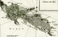 | Details | Le Rouge, George | 1756 |
| Antique map of Isle de Re, France |
|
Le Rouge, George |
|
| 1756 |
| LOC:0 |
| $0.00 | Le-Rouge--George | Antique-map-of-Isle-de-Re--France | SOLD
<br></br>
Fine antique map of the Île de Re in the Charente-Maritime department of western France. Much emphasis on the numerous rocky outcrops, and points that endangered shipping. Contains detailed depictions of the redoubts and forts protecting the island's beaches. Features include Redoutte de Sablanceau, Fort de la Pree, la Flotte, and the walled village of Saint-Martin. The island's south coast is ominously labeled "Cote de la Mer Sauvage". From George le Rouge's "Atlas Nouveau Portatif à l'usage des militaires et du voyages."
<br></br>
The main port of the Île de Ré, Saint-Martin, was fortified by Vauban in 1681 as a one of many forts and citadels built to protect the military harbour of Rochefort. The island was later used as a depot for convicts on their way to the penal settlements of New Caledonia and French Guiana. The old city of Saint-Martin, within the walls of the citadel, was added in 2008 to the World Heritage Site list, along with 11 other fortifications of Vauban across France.
<br></br>
George Le Rouge was a Paris-based engineer and surveyor who had a shop on the Rue Des Grands Augustins, Paris. Le Rouge's tireless work earned him the title "Geographe du Roi". Number 48. |
| 423 | 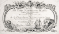 | Details | Le Rouge, George | 1757 |
| Title Page from Recueil des Cotes Maritimes de France |
|
Le Rouge, George |
|
| 1757 |
| LOC:0 |
| $150.00 | Le-Rouge--George | Title-Page-from-Recueil-des-Cotes-Maritimes-de-France | Title page from an atlas of the coasts of France, "Recueil des Cotes Maritimes de France", printed in 1757. The copperplate engraving shows a scene of ships navigating near a rocky coast inset into a decorative scroll-work cartouche decorated with implements of war. Dedicated to the Comte de Clermont.<BR> </BR>
<b>George Le Rouge<b> (1712-1790)was a German-born Paris-based engineer and surveyor who had a shop on the Rue des Grands Augustins. Le Rouge's tireless work for the King earned him the title <b>"Geographe du Roi". </b>
<BR> </BR>
Le Rouge's important works include his edition of the Franklin/ Timothy Folger chart of the Gulf Stream (after Franklin [1]) " and the Pilote américain septentrional (1778) which published Plan de Boston avec les Sondes et les Directions pour la Navigation : traduit de l'Anglais" and "Ocean Atlantique et Mers Adjacentes en quatre feuilles…"
[1] Mount and Page. London. 1768. |
| 1391 | 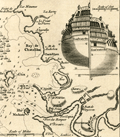 | Details | Gentlemans Magazine | 1758 |
| Antique Map of Basque Roads Anchorage near Rochefort, France |
|
Gentlemans Magazine |
|
| 1758 |
| LOC:7 |
| $125.00 | Gentlemans-Magazine | Antique-Map-of-Basque-Roads-Anchorage-near-Rochefort--France | Neat antique map of Basque Road anchorage related to the failed 1757 British surprise attack of the port of Rochefort, France, along the Charente River. Locations shown include the Isle of Aix, Isle Madame, "Chatalilon" (Chatelaillon) , Fort de la Point, and Fort Lupin.
<br></br>
With a profile view of Fort Fouras with its 17th century fortifications. Although the French were taken by surprise, a bombardment by the British on Fort Fouras was called off when the water off the Fort was discovered to be too shallow. Inset stern view of a Brtish triple-decked ship-of-the line was included to support the discussion in text about the water depth at Fort Fouras.
<br></br>
This fine original copper-engraved map was take from Gentleman's Magazine and Historical Chronicle, Vol 28. |
| 6630 | 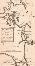 | Details | Gentlemans Magazine | 1758 |
| Coast of Britany Between St. Malos and Cancale Bay Where the English Army Landed June 1758 |
|
Gentlemans Magazine |
|
| 1758 |
| LOC:41 |
| $250.00 | Gentlemans-Magazine | Coast-of-Britany-Between-St--Malos-and-Cancale-Bay-Where-the-English-Army-Landed-June-1758 | Coastal chart of Britany (Brittany) between the ports of St. Malo France and Cancale, centered on St. Malo. The chart was published in Gentlemen's Magazine June, 1758. St. Malo is said to have been the birthplace of Henri Michelot, French Galley Pilot and cartographer.
<br><br>
Map with north at the right Verso is blank. |
| 1251 | 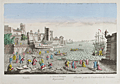 | Details | Daumont, Jean-Francois | 1760 |
| Antique optical view of naval ship construction |
|
Daumont, Jean-Francois |
|
| 1760 |
| LOC:9 |
| $320.00 | Daumont--Jean-Francois | Antique-optical-view-of-naval-ship-construction | Fine French antique optical print (vue d'optique) of an mid eighteenth-century shipyard with ship's carpenters planking the hull a 20-gun warship while two other ships are shown being framed in the background. This interesting scene shows workmen using adzes and board saws to prepare various ship's structural frame members while typical port actvities are underway on all sides.
<br></br>
Although the location is undocumented the print could be based on ship-building activities at Toulon, the home base of France's fleet of warships during that period.
<br></br>
This scarce engraved print was published by Jean-Francois Daumont with attribution at bottom right reading: "A Paris chez Daumont rue St. Martin". |
| 530 | 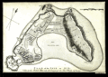 | Details | Jefferys, Thomas | 1761 |
| Plan of the Isle of Aix |
|
Jefferys, Thomas |
|
| 1761 |
| LOC:4 |
| $185.00 | Jefferys--Thomas | Plan-of-the-Isle-of-Aix | Plan of the island of Aix, France, off the mouth of the Charente river on the west coast of France. Depicts the village, vineyards, and fort, gun batteries, and a shipwreck at the northern end of the island. The plan shows the island as it existed after it was captured by the British in 1757 during the Seven Year's War.
<br><br/>
This plate is one of 80 maps included in Jeffery's "A Description of the Maritime Parts of France…" first published in 1761. |
| 502 | 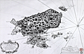 | Details | Depot de la Marine | 1763 |
| Plan de l'ile de Saint Pierre au Sud De Terre-Neuve |
|
Depot de la Marine |
|
| 1763 |
| LOC:65 |
| $550.00 | Depot-de-la-Marine | Plan-de-l-ile-de-Saint-Pierre-au-Sud-De-Terre-Neuve | Antique French sea chart of the island of Saint Pierre about 25 miles south of Newfoundland, in the northwestern Atlantic Ocean.. Lying just offshore of Saint Pierre are numerous smaller islands including Le Grand Colombier; Isle aux Chiens, Isle aux Pigeons, and the gruesomely named "Isle Massacre". The small village is referred to as "le Bourg".
<BR> </BR>
Several features on this chart suggest it was rushed into production. These features include numerous small rectangular areas where the engraving had been smoothed and then re-engraved with place names or descriptors, and at least one area where the chart was smoothed but then left blank. These new additions include "Teste de Galantry"; "Broussailles" ( Fr. Brush wood); and "Bois de Chaufage" (Fr. Heating wood).
<BR> </BR>
In the year this chart was published, 1763, under the terms of the Treaty of Paris, France ceded all its North American possessions, but Saint-Pierre and Miquelon were returned to France. Saint Pierre and Miquelon is today a self-governing overseas territory of France.
<BR> </BR>
Large decorative title cartouche at bottom left is adorned with garlands. Rhumb lines extend from a simple compass rose at right. At bottom right the anchor stamp of the Depot de la Marine and a later red hand-stamp of the "Military Depot" containing the royal coat of arms of the United Kingdom: a shield and crown flanked by a lion and unicorn. |
| 167 |  | Details | Roux, Joseph | 1764 |
| Rade de Marseille |
|
Roux, Joseph |
|
| 1764 |
| LOC:4 |
| $110.00 | Roux--Joseph | Rade-de-Marseille | Antique chart engraving of the Bay of Marseille from the atlas of Mediterranean ports produced by Joseph Roux.<BR> </BR>
There were at least four small atlases of port and coastal charts that originated from Marseille hydrographers in the 18th century. Beginning in approximately 1727 these atlases included works by cartographers
<a rel="nofollow" href= "/MichelotBremondBackground.aspx"> Michelot and Bremond</a>,
<a rel="nofollow" href= "/Creator/Ayrouard--Jacques"> Jacques Ayrouard</a>,
<a rel="nofollow" href= "/Creator/Roux--Joseph"> Joseph Roux</a>
, and Jean Allezard. Comparison between Roux's chart of Marseille Bay and that of Michelot and Bremond shows that although Roux's coastal outline is slightly different than Michelot, the hydrographic soundings were lifted directly from Michelot's charts that were produced 40 years earlier. Plate 20. |
| 997 | 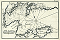 | Details | Roux, Joseph | 1764 |
| Toulon, France harbor |
|
Roux, Joseph |
|
| 1764 |
| LOC:4 |
| $95.00 | Roux--Joseph | Toulon--France-harbor | Antique engraving of the French port of Toulon, France from the atlas of Mediterranean ports produced by Joseph Roux. The old nautical chart concentrates on the harbor around Toulon and its surrounding area, including forts St. Louis, Balaguie, Leguillette, and the larger Fort de la Marque.
<BR> </BR>
Published in Roux's : "Recueil des principaux plans des Ports et Rades de la Mer Mediterranee …" including 121 harbor plans.
<BR> </BR>
There were at least four small atlases of port and coastal charts that originated from Marseille hydrographers in the 18th century. Between approximately 1720 and 1760 these atlases included works by cartographers
<a rel="nofollow" href= "/MichelotBremondBackground.aspx"> Michelot and Bremond</a>,
<a rel="nofollow" href= "/Creator/Ayrouard--Jacques"> Jacques Ayrouard</a>,
<a rel="nofollow" href= "/Creator/Roux--Joseph"> Joseph Roux</a>
, and Jean Allezard.
<BR> </BR>
Plate 23 |
| 168 | 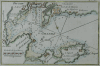 | Details | Roux, Joseph | 1764 |
| Toulon (Sold) |
|
Roux, Joseph |
|
| 1764 |
| LOC:0 |
| $0.00 | Roux--Joseph | Toulon-(Sold) | SOLD<BR> </BR>
Antique engraving of the French port of Toulon from the atlas of Mediterranean ports produced by Joseph Roux. The old nautical chart concentrates on the harbor around Toulon and its surrounding area, including forts St. Louis, Balaguie, Leguillette, and the larger Fort de la Marque.<BR> </BR>
There were at least four small atlases of port and coastal charts that originated from Marseille hydrographers in the 18th century. Between approximately 1720 and 1760 these atlases included works by cartographers
<a rel="nofollow" href= "/MichelotBremondBackground.aspx"> Michelot and Bremond</a>,
<a rel="nofollow" href= "/Creator/Ayrouard--Jacques"> Jacques Ayrouard</a>,
<a rel="nofollow" href= "/Creator/Roux--Joseph"> Joseph Roux</a>
, and Jean Allezard. |
| 1462 | 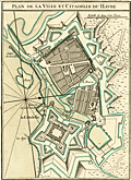 | Details | Bellin, Jacques Nicolas | 1764 |
| Plan of the Fortress and Town of Le Havre France |
|
Bellin, Jacques Nicolas |
|
| 1764 |
| LOC:7 |
| $220.00 | Bellin--Jacques-Nicolas | Plan-of-the-Fortress-and-Town-of-Le-Havre-France | Fine engineer's grade "Plan of the Fortress and Town of Le Havre France". Le Havre lies in France's Normandy region. Shows a Vauban-style fortress, adapted to defend against sustained attack by artillery. By J.N. Bellin 1764 from his Petit Atlas Maritime. Tome 5 No 32. |
| 1427 | 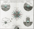 | Details | Brion, Louis, de la Tour | 1766 |
| 18th-century astronomical engraving of spherical orientations |
|
Brion, Louis, de la Tour |
|
| 1766 |
| LOC:9 |
| $250.00 | Brion--Louis--de-la-Tour | 18th-century-astronomical-engraving--of-spherical-orientations | Attractive antique engraving ca. 1766 related to astronomy and in particular to the viewer's perception of various two-dimensional orientations of the earth including the oblique and parallel projections.
<br></br>
Brion's diagrams are organized around a large, attractive, and very decorative compass rose. Additionally, a large and decorative border surrounds the entire print. Two plates were used in the production of this print, one plate for the border, evidenced by the nesting platemarks plainly visible to the viewer. Number 4.
<br></br>
From the "Atlas général civil et ecclésiastique" by Louis Brion de la Tour, Ingénieur-géographe du Roi. |
| 1171 | 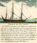 | Details | Ozanne, Nicolas | 1770 |
| Vaisseau de 80 Canons |
|
Ozanne, Nicolas |
|
| 1770 |
| LOC:1 |
| $150.00 | Ozanne--Nicolas | Vaisseau-de-80-Canons | This fine 18th-century hand-colored engraving of a French 80-cannon three-masted war ship is described in the engraved text, including use, armament, names of sail and mastage and crew complement. Several key locations on the rigging are identified in a legend below.
<br></br>
Form Ozanne's "Marine Militaire ou Recueil des differens vaisseaux qui servent à la guerre suivis des manoeuvres qui ont le plus de raport au combat ainsi qua l'attaque et la defense des ports" ca. 1770. Plate 7. |
| 1179 | 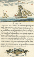 | Details | Ozanne, Nicolas | 1770 |
| French Bateau or Sloop |
|
Ozanne, Nicolas |
|
| 1770 |
| LOC:1 |
| $175.00 | Ozanne--Nicolas | French-Bateau-or-Sloop | This fine 18th-century hand-colored engraving of a French "Bateau" is described in the engraved text. Engraved scene at bottom shows a small swivel cannon and a very scare depiction of a four-barreled naval blunderbuss, the fore-runner of the modern shotgun
<br></br>
From Ozanne's "Marine Militaire ou Recueil des differens vaisseaux qui servent à la guerre suivis des manoeuvres qui ont le plus de raport au combat ainsi qua l'attaque et la defense des ports" ca. 1770. Plate 20. |
| 1180 | 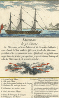 | Details | Ozanne, Nicolas | 1770 |
| Antique Engraving of a French War Ship with 90 Cannons |
|
Ozanne, Nicolas |
|
| 1770 |
| LOC:1 |
| $175.00 | Ozanne--Nicolas | Antique-Engraving-of-a-French-War-Ship-with-90-Cannons | This fine 18th-century hand-colored engraving of a French "Vaisseau de 90 Canons" is described in the engraved text, including maneuvering tactics. Legend at bottom of the engraving identifies several key locations on the rigging of this triple decked French ship-of-the-line including:
<div class="indenttextblock">
<ul style="list-style-type: circle;">
<li>le grand mat d'hune- Main top mast </li>
<li>Petit mat d'hune - Fore top mast</li>
<li>Mat de Perroquet d'artimon ou de Fouge - Mizzen top-gallant mast </li>
<li>Haubans des mats cy dessus - Mast stays</li>
<li>Galaubans des memes mats - Mast backstays </li>
<li>Trelingages des hunes - Top cordage</li>
</ul>
</div>
Form Nicolas Ozanne's "Marine Militaire ou Recueil des differens vaisseaux qui servent à la guerre suivis des manoeuvres qui ont le plus de raport au combat ainsi qua l'attaque et la defense des ports" ca. 1770. |
| 1204 |  | Details | Ozanne, Nicolas | 1770 |
| Antique French Engraving of a Galeasse |
|
Ozanne, Nicolas |
|
| 1770 |
| LOC:0 |
| $175.00 | Ozanne--Nicolas | Antique-French-Engraving-of-a-Galeasse | This fine 18th-century hand-colored engraving of a Galeasse of about 165 feet in length is described in the engraved text:
<div class="indenttextblock">
Les Galeasses, sont de tres grands Batiments, qui vont a voiles et a rames; leur longueur, est de 160, a 170 pieds, la largeur de 30, a 34, et la creuse de 10 a 12. Ces Batiments, portent leur grosse artillerie a la poupe a la proue; les canons de petit calibre se placent sur les flancs, entre les bancs de rameurs, on na point rendu de detail ici pareeque la Figue est trop petit cela.
</div>
<br></br>
A galeasse is a larger vessel than a galley (galère, Fr.) typically powered by 3 lateen-rigged sails as well as oars.
<br></br>
Form Nicolas Ozanne's "Marine Militaire ou Recueil des differens vaisseaux qui servent à la guerre suivis des manoeuvres qui ont le plus de raport au combat ainsi qua l'attaque et la defense des ports" ca. 1770. Plate 16. |
| 448 |  | Details | Benard, Robert | 1770 |
| Fonte des Canons |
|
Benard, Robert |
|
| 1770 |
| LOC:0 |
| $875.00 | Benard--Robert | Fonte-des-Canons | A fine gift for anyone with an interest in engineering, weaponry, or European history. A scarce pair (2) of archivally-matted antique copperplate engravings by Robert Benard depicting large mortars ca. 1738. In the early 18th century a mortar was essentially a squat, wide tube with very thick walls to withstand high pressure.
<br></br>
<img src="/ZoomifyImages/SC_309/SC_309_400x300.jpg" alt="de Passebon: Bomb Ketch. 1690." width="200" align="bottom" style="margin: 5px 10px 5px 0px"> </BR>
<a href="https://www.rarecharts.com/ShowDetail/Creator/Henri-Sbonski-de-Passebon/Title/Galiote-a-bombe/309" target="_blank">The 'Galiote a bombe' </a>(bomb vessel or bomb ketch) pictured inset is an antique engraving in our inventory created ca. 1690 by French galley Captain Henry Sbonski de Passebon (1637-1705). Either one or two mortars were usually placed aboard a bomb vessel which could be one of two types of vessels, either a specially built ketch (ketch: a two-masted, fore-and-aft-rigged sailboat with a mizzenmast smaller than the foremast) or, as is the case here, a converted three-masted vessel where the foremast had been removed, to provide a good deck space forward for the mortars.
<BR> </BR>
As a Captain in France's Corps des Galere, de Passebon was intimately familiar with this type ship and he is reported to have participated during the French bombardment of Genoa in 1684 , aboard the "la Perle" .
</BR>
The cannon are decorated with crown and globe containing three fleur-de-lis, figures representing the French royal coat of arms in the eighteenth century. From Diderot's "Encyclopédie ou Dictionnaire raisonné des sciences, des arts et des métiers, par une Société de Gens de lettres. Total dimensions with mat about 16.5" W x 19.5" H. Mat approx 5" per side. "Benard direxit". |
| 445 |  | Details | Bellin, Jacques Nicolas | 1772 |
| Hydrographie Francoise (Title Page) |
|
Bellin, Jacques Nicolas |
|
| 1772 |
| LOC:55 |
| $400.00 | Bellin--Jacques-Nicolas | Hydrographie-Francoise-(Title-Page) | Gorgeous copperplate re-strike engraving of the title page to Bellin's sea-atlas, the Hydrographie Francoise. With the circular stamp of the Depot de la Marine. Undated. Price One and one-half francs. No. 1.
<BR> </BR>
We believe the engraving is an early 20th century re-strike from the original copper plate produced at the French Chalcographie du Louvre. La Chalcographie du Louvre is a repository, consisting of more that 13,000 original plates from the Louvre's archives, housed upstairs above the Louvre's Paris galleries . Upon request visitors can have an engraving produced from the original plate on museum-quality paper by a master printer. V.196. |
| 162 |  | Details | Jefferys, Thomas | 1774 |
| Plan of the City and Harbour of Toulon |
|
Jefferys, Thomas |
|
| 1774 |
| LOC:4 |
| $175.00 | Jefferys--Thomas | Plan-of-the-City-and-Harbour-of-Toulon | Nice antique copperplate-engraved plan from 1774 of the Vauban-style fortifications around Toulon, France includes the King's harbor, merchant's harbor, arsenal, and the two city gates, where the beginnings of development outside the walls is barely visible.
<BR> </BR>
Despite its massive bastions and the support of a combined British/Spanish naval force, the fortress fell to French Republican forces in 1793 forcing the fleet to withdraw. It was during the Siege of Toulon that 24 year old Napoleon Bonaparte won a promotion from Captain to Brigadier General for his leadership including strategic placement of artillery batteries.
<BR> </BR>
Printed for Faden and Jefferys in 1774; the two volumes in the series contained 87 charts of the sea coast and coastal fortifications. |
| 4869 |  | Details | Jefferys, Thomas | 1774 |
| Three plans of Dunkirk France 960 1400 1658 |
|
Jefferys, Thomas |
|
| 1774 |
| LOC:13 |
| $150.00 | Jefferys--Thomas | Three-plans-of-Dunkirk-France-960-1400-1658 | Three plans of Dunkirk (Dunkerque), France on a single sheet of fine watermarked laid paper ca. 1760. Engraved by prolific British engraver and publisher Thomas Jefferys (1710-1771):
<div class="indenttextblock">
<ul style="list-style-type: circle;">
<li> A plan of Dunkirk as first walled round in 960 by Baldwin 3, Earl of Flanders.</li>
<li> A plan of Dunkirk as it was first fortifies in 1400 by Robert de Marle.</li>
<li> A plan of Dunkirk as it was fortified when taken by Marshal Turenne June 28, 1658.</li>
<br></br>
From Jefferys' "A description of the maritime parts of France, containing a particular account of all the fortified towns, forts, harbours, bays, and rivers …". Published by Faden and Jefferys, 1774. Plate III. |
| 151 |  | Details | Jefferys, Thomas | 1774 |
| Coast of France from Callais to Fecamp |
|
Jefferys, Thomas |
|
| 1774 |
| LOC:0 |
| $0.00 | Jefferys--Thomas | Coast-of-France-from-Callais-to-Fecamp | SOLD
<br></br>
Neat chart of the English and French coasts along the "British Channel" near the Straits of Dover. On the British side coverage extends from Beachy Head past the South Foreland. Printed for Faden and Jefferys in 1774 the two volumes in the series contained 87 charts of the sea coast and fortifications. |
| 1253 |  | Details | Bonne, Rigobert | 1778 |
| Antique miniature chart of the coasts of Normandy and Brittany |
|
Bonne, Rigobert |
|
| 1778 |
| LOC:0 |
| $0.00 | Bonne--Rigobert | Antique-miniature-chart-of-the-coasts-of-Normandy-and-Brittany | SOLD
<br></br>
Fine antique miniature nautical chart from 1778 of France's <b>Normandy and Brittany coastline</b> along the English Channel. Coverage at sea includes the Channel Islands of Guernsey, Jersey, and Alderney. Ports and towns shown include St. Malo, Avranche, Cherbourg, Barfleur, Bayeux, Caen, Havre du Grace (La Havre). This scarce chart was published during the golden age for miniature maps and is one of the few miniature charts printed during that period.
<br></br>
From Rigobert Bonne's miniature nautical atlas "Atlas maritime ou Cartes réduites de toutes les Côtes de France avec des cartes particulières des isles voisines les plus considérables, suivies des plans des principales villes maritimes de ce royaume." One of 12 miniature charts published in the Atlas Maritime. Published by Lattre from Paris. With the royal privilege. No. 3.
<br></br>
This scarce miniature copper-plate engraving contains much of the same information found on larger charts- rhumb lines; an adjustment for magnetic variation; numerous depth soundings; headlands, capes, navigation hazards and sand banks that are clearly identified.
<br></br>
Rigobert Bonne (1727-1794) was the successor to Jacques Nicolas Bellin as Royal Cartographer to France in the office of the Hydrographer at the Depôt de la Marine. Bonne first came to prominence when he published a number of charts in the Atlas Maritime in 1762. He is better known for later publications, including the Atlas Encyclopedique, which he collaborated on with Nicholas Desmarest, as well as the maps he produced for Raynal's Atlas de Toutes Les Parties Connues du Globe Terrestre, which was published in 1780. |
| 1242 | 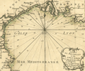 | Details | Bonne, Rigobert | 1778 |
| Miniature antique nautical chart of the Gulf of Lyon |
|
Bonne, Rigobert |
|
| 1778 |
| LOC:7 |
| $135.00 | Bonne--Rigobert | Miniature-antique-nautical-chart-of-the-Gulf-of-Lyon | Fine miniature antique nautical chart of the Gulf of Lyon and the French coast of the regions of <b>Provence and Languedoc-Roussillon</b>. Numerous towns and villages are identified by name, including Perpignan, Narbonne, Beziers, Agde, Sete (Cette), Montpellier, Arles, Aix, la Ciotat, Cassis, and Marseilles. The chart ends to the east near the resort town of Six Fours les Plages. Small coverage of Spain includes Roses.
<br></br>
Despite its small size this scarce miniature engraving contains most features that appear on larger sea charts- numerous depth soundings are provided; navigational hazards and sand banks are clearly identified; and rhumb lines are provided with a 18 degree compass adjustment for magnetic variation. Bonne provides very little detail about the interior topography.
<br></br>
From Rigobert Bonne's miniature nautical atlas "Atlas maritime ou Cartes réduites de toutes les Côtes de France avec des cartes particulières des isles voisines les plus considérables, suivies des plans des principales villes maritimes de ce royaume." One of 12 charts of France published in the Atlas Maritime which are considered to among the very few miniature nautical charts published during the golden age of miniature maps . Published by Lattre from Paris. With the royal privilege. No. 2.
<br></br>
Rigobert Bonne (1727-1794) was the successor to Jacques Nicolas Bellin as Royal Cartographer to France in the office of the Hydrographer at the Depôt de la Marine. Bonne first came to prominence when he published a number of charts in the Atlas Maritime in 1762. |
| 1241 | 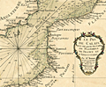 | Details | Bonne, Rigobert | 1778 |
| Miniature antique nautical chart of the Strait of Dover |
|
Bonne, Rigobert |
|
| 1778 |
| LOC:7 |
| $160.00 | Bonne--Rigobert | Miniature-antique-nautical-chart-of-the-Strait-of-Dover | Fine miniature antique nautical chart of the coasts near the <b>Strait of Dover</b> (Pas de Calais), the narrowest part of the English Channel. Coverage on this attractive miniature sea chart includes coastal France and England. Bonne shows a few towns on the English side of the channel including Hastings, Rye, Dover (Douvres) , Romney and Sandwich. On the French and Belgian side of the English channel Bonne locates numerous towns and villages including Ostend, Dunkirk, Calais, Boulogne, Etaples, Montreuil, Abbeville, Dieppe, and Fecamp.
<br></br>
Despite its small size this scarce miniature engraving contains most features found on larger sea charts- numerous headlands are noted; depth soundings are provided; anchorages, hazards and sand banks are clearly identified; and rhumb lines are provided with a 18 3/4 degree compass adjustment for magnetic variation. Unlike several other charts in the series, on this particular miniature chart Bonne provides very little detail about the interior topography of either England or France.
<br></br>
From Rigobert Bonne's miniature nautical atlas "Atlas maritime ou Cartes réduites de toutes les Côtes de France avec des cartes particulières des isles voisines les plus considérables, suivies des plans des principales villes maritimes de ce royaume." One of 12 charts published in the Atlas Maritime which are considered to among the very few miniature nautical charts published during the golden age of miniature maps . Published by Lattre from Paris. With the royal privilege. No. 2.
<br></br>
Rigobert Bonne (1727-1794) was the successor to Jacques Nicolas Bellin as Royal Cartographer to France in the office of the Hydrographer at the Depôt de la Marine. Bonne first came to prominence when he published a number of charts in the Atlas Maritime in 1762. |
| 1252 | 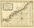 | Details | Bonne, Rigobert | 1778 |
| Antique miniature chart of the coast near Provence, France |
|
Bonne, Rigobert |
|
| 1778 |
| LOC:7 |
| $185.00 | Bonne--Rigobert | Antique-miniature-chart-of-the-coast-near-Provence--France | Fine antique miniature nautical chart of the <b>Provencal Coast</b> of France on the Mediterranean Sea. Coverage includes the villages of Toulon, St. Tropez, Cannes, Antibes, Ventimille, Oneille, Albinga, Genes, and the Principality of Monaco.
<br></br>
From Rigobert Bonne's miniature nautical atlas "Atlas maritime ou Cartes réduites de toutes les Côtes de France avec des cartes particulières des isles voisines les plus considérables, suivies des plans des principales villes maritimes de ce royaume." One of 12 charts published in the Atlas Maritime which are considered to among the very few miniature nautical charts published during the golden age of miniature maps . Published by Lattre from Paris. With the royal privilege. No. 9.
<br></br>
This scarce miniature copper-plate engraving contains much of the same information found on larger charts- rhumb lines; an adjustment for magnetic variation; depth soundings that are numerous; headlands, capes, navigation hazards and sand banks that are clearly identified.
<br></br>
Rigobert Bonne (1727-1794) was the successor to Jacques Nicolas Bellin as Royal Cartographer to France in the office of the Hydrographer at the Depôt de la Marine. Bonne first came to prominence when he published a number of charts in the Atlas Maritime in 1762. He is better known for later publications, including the Atlas Encyclopedique, which he collaborated on with Nicholas Desmarest, as well as the maps he produced for Raynal's Atlas de Toutes Les Parties Connues du Globe Terrestre, which was published in 1780. |
| 1233 | 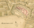 | Details | Bonne, Rigobert | 1778 |
| Scarce antique miniature plan of Toulon, France |
|
Bonne, Rigobert |
|
| 1778 |
| LOC:7 |
| $90.00 | Bonne--Rigobert | Scarce-antique-miniature-plan-of-Toulon--France | Scarce miniature plan of the fortified port city of Toulon, France, the chief base for France's large naval fleet the Vaisseaux de Guerre. Toulon lies along the Mediterranean coast in the Provence region of southern France. This small (4 1/2 " x 3 1/2 ") antique engraved plan of Toulon shows Vauban-style defensive walls around the city as well as the old harbor "vieille darce" (built 1604 - 1610) and the new harbor or "nouvelle darce". Maps the roads connecting to Toulon.
<br></br>
In a brief description of Toulon at the end of the atlas Bonne wrote:
<div class="indenttextblock">
Toulon, assez grande Ville et Port de Mer en Provence, est dans une situation admirable. Des Montagnes eleves jusquaux nues la couvrent au Septentrion et rendent son Port, qui est fort grand, une des plus sur de la Mediterranee. Ce Port, destine aux Vaisseaux de guerre, est une des plus connus de l'Europe; le entre est defendue par nombre de batteries et par plusieurs forts…"
</div>
<br />
From Rigobert Bonne's miniature nautical atlas "Atlas maritime ou Cartes réduites de toutes les Côtes de France avec des cartes particulières des isles voisines les plus considérables, suivies des plans des principales villes maritimes de ce royaume." Published by Lattre from Paris. With the royal privilege. No. 30.
<br></br>
Bonne attributes the source the of plans to three others: "… des belles Vues de nos Ports, que donnent M.M. Cochin et Les Bas, d'apres les excellens Tableaux de M. Vernet." |
| 3677 | 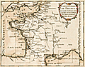 | Details | Bonne, Rigobert | 1778 |
| Antique master or key chart to the Petit Atlas Maritime |
|
Bonne, Rigobert |
|
| 1778 |
| LOC:7 |
| $160.00 | Bonne--Rigobert | Antique-master-or-key-chart-to-the-Petit-Atlas-Maritime | Scarce antique miniature master page to Rigobert Bonne's miniature sea atlas of coastal France. Bonne's scarce atlas contained 12 miniature nautical charts of coastal France and 18 miniature plates of port and harbor plans. On this master map nine rectangles show the viewer the area encompassed by each of Bonne's nine charts as shown in our inventory.
<br></br>
From Rigobert Bonne's miniature nautical atlas "Atlas maritime ou Cartes réduites de toutes les Côtes de France avec des cartes particulières des isles voisines les plus considérables, suivies des plans des principales villes maritimes de ce royaume." Published by Lattre from Paris. With the royal privilege. Engraved by Monnet after a design by L. Legrand.
<br></br>
Rigobert Bonne was the successor to Jacques Nicolas Bellin as Royal Cartographer to France in the office of the Hydrographer at the Depôt de la Marine. |
| 1234 | 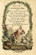 | Details | Bonne, Rigobert | 1778 |
| Antique title page to the miniature Atlas Maritime |
|
Bonne, Rigobert |
|
| 1778 |
| LOC:7 |
| $200.00 | Bonne--Rigobert | Antique-title-page-to-the-miniature-Atlas-Maritime | Scarce antique miniature title page to Rigobert Bonne's miniature sea atlas of coastal France. Bonne's scarce atlas contained 12 miniature nautical charts of coastal France and 18 miniature plates of port and harbor plans. With Table of Contents, colored attractive frontispiecce, and end notes.
<br></br>
From Rigobert Bonne's miniature nautical atlas "Atlas maritime ou Cartes réduites de toutes les Côtes de France avec des cartes particulières des isles voisines les plus considérables, suivies des plans des principales villes maritimes de ce royaume." Published by Lattre from Paris. With the royal privilege. Engraved by Monnet after a design by L. Legrand.
<br></br>
Rigobert Bonne was the successor to Jacques Nicolas Bellin as Royal Cartographer to France in the office of the Hydrographer at the Depôt de la Marine. |
| 1238 | 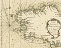 | Details | Bonne, Rigobert | 1778 |
| Antique miniature nautical chart of Brittany, France |
|
Bonne, Rigobert |
|
| 1778 |
| LOC:0 |
| $0.00 | Bonne--Rigobert | Antique-miniature-nautical-chart-of-Brittany--France | SOLD
<br></br>
Fine antique miniature nautical chart of the coast of <b>Brittany, France</b> (Bretagne) in the northwest of that country. Coverage on this attractive miniature sea chart includes Île-de-Bréhat, Morlaix, Ushant, Brest, l'Orient, Port Louis, and Quiberon.
<br></br>
Despite its small size this scarce copper-plate engraving contains much of what is found on larger charts- numerous headlands are noted; depth soundings are provided; hazards and sand banks are clearly identified; and rhumb lines are provided with a 19 degree compass adjustment for magnetic variation. Unlike other charts in the series, on this particular miniature chart Bonne provides very little detail about the interior topography and geography of Brittany.
<br></br>
From Rigobert Bonne's miniature nautical atlas "Atlas maritime ou Cartes réduites de toutes les Côtes de France avec des cartes particulières des isles voisines les plus considérables, suivies des plans des principales villes maritimes de ce royaume." One of 12 charts published in the Atlas Maritime which are considered to among the very few miniature nautical charts published during the golden age of miniature maps . Published by Lattre from Paris. With the royal privilege. No. 4.
<br></br>
Rigobert Bonne (1727-1794) was the successor to Jacques Nicolas Bellin as Royal Cartographer to France in the office of the Hydrographer at the Depôt de la Marine. Bonne first came to prominence when he published a number of charts in the Atlas Maritime in 1762. He is better known for later publications, including the Atlas Encyclopedique, which he collaborated on with Nicholas Desmarest, as well as the maps he produced for Raynal's Atlas de Toutes Les Parties Connues du Globe Terrestre, which was published in 1780. |
| 1271 | 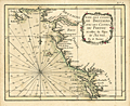 | Details | Bonne, Rigobert | 1778 |
| Antique miniature chart of the French coast at the Bay of Biscay |
|
Bonne, Rigobert |
|
| 1778 |
| LOC:0 |
| $0.00 | Bonne--Rigobert | Antique-miniature-chart-of-the-French-coast-at-the-Bay-of-Biscay | SOLD
<br></br>
Fine antique French miniature nautical chart of the French coast on the <b>Bay of Biscay</b> or Golfe de Gascogne (Fr.) (also Golfo de Biscaia or Gollfo de Vizcaya (Sp.)) in the provinces of Poitou, Aunis, and Brittany (Bretagne). Coverage includes the Quiberon Peninsula, Belle Isle, Nantes, Ile de Re, la Rochelle, Rochefort, mouth of the Loire River, and the Ile de Oleron.
<br></br>
From Rigobert Bonne's miniature nautical atlas "Atlas maritime ou Cartes réduites de toutes les Côtes de France avec des cartes particulières des isles voisines les plus considérables, suivies des plans des principales villes maritimes de ce royaume." One of 12 charts published in the Atlas Maritime which are considered to among the very few miniature nautical charts published during the golden age of miniature maps . Published by Lattre from Paris. With the royal privilege. No. 5.
<br></br>
This scarce miniature copper-plate engraving contains much of the same information found on larger nautical charts- rhumb lines; an adjustment for magnetic variation; numerous depth soundings; anchorages, headlands, capes, navigation hazards and sand banks that are clearly identified.
<br></br>
Rigobert Bonne (1727-1794) was the successor to Jacques Nicolas Bellin as Royal Cartographer to France in the office of the Hydrographer at the Depôt de la Marine. Bonne first came to prominence when he published a number of charts in the Atlas Maritime in 1762. He is better known for later publications, including the Atlas Encyclopedique, which he collaborated on with Nicholas Desmarest, as well as the maps he produced for Raynal's Atlas de Toutes Les Parties Connues du Globe Terrestre, which was published in 1780. |
| 1237 | 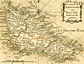 | Details | Bonne, Rigobert | 1778 |
| Antique miniature nautical chart of Belle Ile, France |
|
Bonne, Rigobert |
|
| 1778 |
| LOC:0 |
| $0.00 | Bonne--Rigobert | Antique-miniature-nautical-chart-of-Belle-Ile--France | SOLD
<br></br>
Fine antique miniature nautical chart of <b>Belle Île</b> (Belle-Isle), France in the English Channel off the French coast of Brittany. Coverage on this attractive miniature sea chart includes geographical and topographical detail within the four communes of Sauzon, Bangor, Le Palais, and Locmaria (Lomaria).
<br></br>
Despite its small size this scarce copper-plate engraving contains much of what is found on larger charts- numerous headlands are noted; depth soundings are numerous; hazards and sand banks are clearly identified; and rhumb lines are provided with a compass adjustment for magnetic variation.
<br></br>
From Rigobert Bonne's miniature nautical atlas "Atlas maritime ou Cartes réduites de toutes les Côtes de France avec des cartes particulières des isles voisines les plus considérables, suivies des plans des principales villes maritimes de ce royaume." One of 12 charts published in the Atlas Maritime which are considered to among the very few miniature nautical charts published during the golden age of miniature maps . Published by Lattre from Paris. With the royal privilege. No. 11.
<br></br>
Rigobert Bonne (1727-1794) was the successor to Jacques Nicolas Bellin as Royal Cartographer to France in the office of the Hydrographer at the Depôt de la Marine. Bonne first came to prominence when he published a number of charts in the Atlas Maritime in 1762. He is better known for later publications, including the Atlas Encyclopedique, which he collaborated on with Nicholas Desmarest, as well as the maps for Raynal's Atlas de Toutes Les Parties Connues du Globe Terrestre, published in 1780. |
| 1266 | 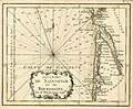 | Details | Bonne, Rigobert | 1778 |
| Antique miniature chart of the Biscayan coast near Bordeaux, France |
|
Bonne, Rigobert |
|
| 1778 |
| LOC:7 |
| $120.00 | Bonne--Rigobert | Antique-miniature-chart-of-the-Biscayan-coast-near-Bordeaux--France | Fine antique French miniature nautical chart of the <b>Bourdelois Coast</b> of France near Bourdeaux, France, Cape Ferret, Blaye and the Gironde River.
<br></br>
From Rigobert Bonne's miniature nautical atlas "Atlas maritime ou Cartes réduites de toutes les Côtes de France avec des cartes particulières des isles voisines les plus considérables, suivies des plans des principales villes maritimes de ce royaume." One of 12 charts published in the Atlas Maritime which are considered to among the very few miniature nautical charts published during the golden age of miniature maps . Published by Lattre from Paris. With the royal privilege. No. 6.
<br></br>
This scarce miniature copper-plate engraving contains much of the same information found on larger charts- rhumb lines; an adjustment for magnetic variation; numerous depth soundings; headlands, capes, navigation hazards and sand banks that are clearly identified.
<br></br>
Rigobert Bonne (1727-1794) was the successor to Jacques Nicolas Bellin as Royal Cartographer to France in the office of the Hydrographer at the Depôt de la Marine. Bonne first came to prominence when he published a number of charts in the Atlas Maritime in 1762. He is better known for later publications, including the Atlas Encyclopedique, which he collaborated on with Nicholas Desmarest, as well as the maps he produced for Raynal's Atlas de Toutes Les Parties Connues du Globe Terrestre, which was published in 1780. |
| 1267 | 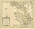 | Details | Bonne, Rigobert | 1778 |
| Isle de Re and Isle d'Oleron, France |
|
Bonne, Rigobert |
|
| 1778 |
| LOC:0 |
| $0.00 | Bonne--Rigobert | Isle-de-Re-and-Isle-d-Oleron--France | SOLD
<br></br>
Antique miniature nautical chart of the Atlantic west coast of France near Rochefort and la Rochelle. Includes the <b>Isle de Re</b> and the <b>Isle d'Oleron</b>. The Pertuis d'Antioche, a strait on the western coast of France lies between the two islands.
<br></br>
From Rigobert Bonne's miniature nautical atlas "Atlas maritime ou Cartes réduites de toutes les Côtes de France avec des cartes particulières des isles voisines les plus considérables, suivies des plans des principales villes maritimes de ce royaume." One of 12 charts published in the Atlas Maritime which are considered to among the very few miniature nautical charts published during the golden age of miniature maps .
<br></br>
Published by Lattre from Paris. With the royal privilege. No. 12.
<br></br>
This scarce miniature copper-plate engraving contains much of the same information found on larger charts- rhumb lines; an adjustment for magnetic variation; numerous depth soundings; headlands, capes, navigation hazards and sand banks that are clearly identified.
<br></br>
Rigobert Bonne (1727-1794) was the successor to Jacques Nicolas Bellin as Royal Cartographer to France in the office of the Hydrographer at the Depôt de la Marine. Bonne first came to prominence when he published a number of charts in the Atlas Maritime in 1762. He is better known for later publications, including the Atlas Encyclopedique, which he collaborated on with Nicholas Desmarest, as well as the maps he produced for Raynal's Atlas de Toutes Les Parties Connues du Globe Terrestre, which was published in 1780. |
| 3666 | 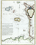 | Details | Avery, Joseph | 1779 |
| Rare chart of the Channel Islands after Joseph Avery |
|
Avery, Joseph |
|
| 1779 |
| LOC:57 |
| $4,200.00 | Avery--Joseph | Rare-chart-of-the-Channel-Islands-after-Joseph-Avery | Unrecorded French chart of Îles de la Manche in the English Channel- the Normandy coast and Channel Islands after the survey of Joseph Avery. Islands include Alderney, Guernsey, Jersey, Herm, and Sark.
<br></br>
Though similar to Beaurain's chart of 1757, no copy of this very attractive work after Avery is found online nor in AMPR. No copy of Avery's own original survey is found anywhere but his work should be dated between 1721 and 1742.
<br></br>
Joseph Avery was born in Scotland and is known to have charted the southern coast of England ca. 1721 and to have published a "well approved" map of that work. Avery emigrated to Charleston, SC where he worked as a ship builder and was hired in 1742 as surveyor to the Georgia province. (Cadle, Farris W. Georgia Land Surveying History and Law. University of Georgia Press. 1991. Pages 4-26)
<br></br>
J.F.W. DeBarres chart of the Coast Rivers and Inlets of the Province of Georgia (1780) is credited to be after the work of Joseph Avery and others. |
| 44 | 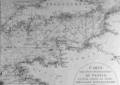 | Details | Mannevillette, d'Apres | 1780 |
| Carte des Cotes Occidentales de France |
|
Mannevillette, d'Apres |
|
| 1780 |
| LOC:0 |
| $0.00 | Mannevillette--d-Apres | Carte-des-Cotes-Occidentales-de-France | SOLD<BR> </BR>
Two-page black and white antique nautical chart of west France, northern Spain, southern Britain, and Ireland on chain-laid paper. Illegible watermark. Primary focus is coverage of the Gulf of Gascogne and the approaches to the English Channel. Small central compass rose with numerous rhumb lines. North at top of chart. Plate I. |
| 835 | 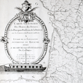 | Details | Dupain Triel, Jean-Louis | 1781 |
| Antique thematic map of French rivers and canals |
|
Dupain Triel, Jean-Louis |
|
| 1781 |
| LOC:0 |
| $3,000.00 | Dupain-Triel--Jean-Louis | Antique-thematic-map-of-French-rivers-and-canals | A large and rare antique thematic map of the rivers, streams, and canals of France with a very fine decorative cartouche. First and only edition. In two un-joined sheets. 36" W x 37" H when joined. Very decorative title cartouche with illustration of a late 18th century river barge with a large rudder; the size probably was necessitated by a small turning angle limited to the width of the barge cabin just aft of amidships. Possibly influenced by Sanson's 1641 "Carte des rivières de la France, curieusement recherchée" but Dupain-Triel's waterways map is much larger and contains greater detail.
<br></br>
Une grande et rare carte thématique antique des rivières, ruisseaux et canaux de France avec un très beau cartouche décoratif. Première et unique édition. Dans deux feuilles non jointes. 36 "L x 37" H une fois joint. Cartouche titre très décorative avec illustration d'une barge fluviale. Peut-être influencé par 1641 "Carte des rivières de la France de Sanson, curieusement recherchée" mais la carte des cours d'eau Dupain-Triel est beaucoup plus grande et contient plus de détails.
<br></br>
Both sheets of a 2 sheet map (not joined) of France by J.L. Dupain-Triel Sr. Rare, only one holding listed in OCLC/World Cat. Only two sales recorded in the AMPR.
<br></br>
In 1782 Dupain-Triel paid for the typesetting and engraving of a manuscript by Marcellin du Carla that proposed the use of contour lines as a means of adding elevation information to terrestrial maps and Dupain-Triel Sr. is distinguished as the maker of the first contour map of France in 1791, based on du Carla's method. This thematic map is noteworthy in that it does not contain any contour information although it is clear that when the map was published Dupain Triel Sr. had strong interest in the topic. (Konvitz, Joseph. "Cartography in France, 1660-1848: Science, Engineering, and Statecraft". University of Chicago Press. 1987. pp. 76-80.) |
| 2550 | 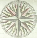 | Details | Clouet, Jean-Baptiste | 1787 |
| Fine antique print of a wind rose. |
|
Clouet, Jean-Baptiste |
|
| 1787 |
| LOC:9 |
| $270.00 | Clouet--Jean-Baptiste | Fine-antique-print-of-a-wind-rose- | Large delicately colored original engraved example of a wind rose by J.B. Clouet. The 32 winds of the wind rose are each named in French, Italian, Latin, and Spanish (e.g. for the West wind: "Ouest", "Ponente", "Favonius Zephirus" and "Oeste"). This fine antique wind rose is surrounded on two sides by French text and measures 12 inches in diameter. |
| 45 | 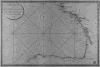 | Details | Depot de la Marine | 1790 |
| Carte Reduite de Golfe de Gascogne |
|
Depot de la Marine |
|
| 1790 |
| LOC:0 |
| $0.00 | Depot-de-la-Marine | Carte-Reduite-de-Golfe-de-Gascogne | SOLD
<br></br>
Large, no-nonsense antique copperplate engraved navigational chart on wove paper. Coverage is of the Gulf of Gascogne from Isle d'Ouessant to Cape Finisterre.
<br></br>
Published by the French Depot de la Marine in 1790. |
| 437 |  | Details | Anonymous | 1790 |
| Au nom du Peuple Francais |
|
Anonymous |
|
| 1790 |
| LOC:0 |
| $225.00 | Anonymous | Au-nom-du-Peuple-Francais | Large copperplate of Neptune poised on the stern of a French sailing vessel wielding a trident above the French cypher "RF" (Republique Francais). This fine work from the original 18th century plate, is an early 20th century restrike from the original plate by the Louvre of an etching and engraving by Tardieu created ca. 1790. Believe the engraving is similar to the letterhead that Hue designed for the French Ministry of Marine. <BR> </BR>
La Chalcographie du Louvre is a repository of more that 13,000 original plates from the Louvre's archives, housed upstairs above the Louvre's Paris galleries . Upon request visitors can have a engraving produced from one of those original plates by master printers on museum-quality paper. V. 202<BR> </BR> |
| 40 |  | Details | La Bretonniere | 1792 |
| Cotes de France- Departement du Pas de Calais |
|
La Bretonniere |
|
| 1792 |
| LOC:0 |
| $225.00 | La-Bretonniere | Cotes-de-France--Departement-du-Pas-de-Calais | Depot de la Marine antique copperplate engraved nautical chart by La Bretonniere of the Pas de Calais region focused on the town of Calais and its near offshore waters. Sand banks, soundings, and coastal features are shown with fine detail. Top right of chart annotated with manuscript "16" in large letters.<BR> </BR>
Of special historical note on this antique chart are two items that reflect the French revolution: Date of " l'An I " and the Depot de la Marine stamp with "E.F." replacing the Fleur de Lis. |
| 1383 | 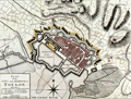 | Details | Sayer, Robert | 1793 |
| Antique map of Provence, France related to the Siege of Toulon |
|
Sayer, Robert |
|
| 1793 |
| LOC:0 |
| $300.00 | Sayer--Robert | Antique-map-of-Provence--France-related-to-the-Siege-of-Toulon | Three fine antique maps on one sheet related to the French Revolutionary War, and in particular the Siege of Toulon (Aug. 1793 - Dec. 1793). It was at the important naval base of Toulon where young Napoleon Bonaparte won his first military victory. Coverage of coastal Provence, France includes the Côte d'Azure with Monaco, Nice, Antibes, and St. Tropez. Trending to the west it shows the Bay de Hyeres, Marseilles, Avignon, Agde, Narbonne, Perpignan, and Port Vendres.
<BR></BR>
The top map shows the coastline of Southern France from the border with Italy to the border with Spain. Fortified towns and post roads are delineated. Bottom left inset map of "The Roads of Toulon with the Adjacent Country" showing the position of Toulon at much greater scale, and extensive soundings, anchorages, and landmarks in the Little Road and Great Road of Toulon. (Note: A road is a sheltered location where vessels may lie at anchor). Bottom right inset is "Plan of the City and Harbour of Toulon", a detailed plan showing the city with references to the various bastions.
<BR></BR>
Published October 10, 1793 by Robert Sayer & co. Fleet Street, London. |
| 962 |  | Details | Malham, John | 1797 |
| A Correct Chart of the Coasts of the Bay of Biscay |
|
Malham, John |
|
| 1797 |
| LOC:0 |
| $0.00 | Malham--John | A-Correct-Chart-of-the-Coasts-of-the-Bay-of-Biscay | SOLD
<BR> </BR>
Antique engraved nautical chart of the Bay of Biscay, probably the earliest small-scale map of Biscay Bay to be printed in the United States (1797). Coverage extends from the coasts of Normandy and Brittany
past Bordeaux and Gascony and terminates in Galicia near Cape Ferrol. Key features include Ushant, Brest, la Rochelle, Rochefort, Bayonne; and the mouths of the Vilaine, Loire, and Gironde Rivers.
<BR> </BR>
Though small in size, the chart contains numerous soundings and descriptions of the composition of the sea-floor (e.g. "Broken Shells", "Grey Sand" or "Whitish Mixt Sand") .
<BR> </BR>
This chart comes from an early nautical gazetteer or geographical dictionary produced first in England and after 1796 in the United States by John Malham. Rev. John Malham was a prolific Yorkshire-born author who produced other diverse works that include "Navigation Made Easy and Familiar", "Twenty-Two Sermons on Doctrinal and Practical Subjects" and "The Scarcity of Wheat considered". Malham died near London in 1807. (Gentleman's Magazine, Vol 102, 1807, p. 568).
<BR> </BR>
Colophon at end of Volume 1 states that the work is "From the prefs of Samuel Etheridge, No. 9 Newbury Street, Boston, 1797"). |
| 5198 |  | Details | Anonymous | 1800 |
| Two French Manuscript Cadastral Plans near Dijon, France. |
|
Anonymous |
|
| 1800 |
| LOC:77 |
| $165.00 | Anonymous | Two-French-Manuscript-Cadastral-Plans-near-Dijon--France- | Two manuscript cadastral plans of lands in France belonging to Mr. Jacob, one with grape vines, ca. 1790. Today there are at least two wine producers operating in France with the name Jacob. Both wineries lie about 30 km southwest of Dijon, France near the main road : Domaine Jacob and Domaine Lucien Jacob.
<br></br>
<div class="indenttextblocksingle">
1) MS plan of an L-shaped lot belonging to Mr. Jacob and containing 49 ares and 49 centiares. Site plan was located at the intersection of the "Grande route de Dijon a Paris" and the "Chemin de Memont a Dijon." North oriented to the right with a fine arrow direction indicator. 8" x 6". </br>
2) MS plan of two lots belonging to Mr. Jacob. One lot planted with grapevines. 7" x 5".
</div>
</br>
A French "are" was a metric measurement equal to 100 square meters; a "centiare" was equal to one square meter. Usage of ares and centiares dates the map after the French Revolution, when France adopted the Metric System of measurement. |
| 1107 |  | Details | Dezauche, J.C. | 1800 |
| Unique and unusual paste up engraver's copy of an unpublished Dezauche map |
|
Dezauche, J.C. |
|
| 1800 |
| LOC:9 |
| $0.00 | Dezauche--J-C- | Unique-and-unusual-paste-up-engraver-s-copy-of-an-unpublished-Dezauche-map | SOLD<br></br>
A very unusual 216 year old paste-up map-engraver's working copy before the era of photographic reproduction. The paste-up provides a rare glimpse into the map-making thought process and the cartographic design process of the early 19th century during the French Revolution.
<br></br>
The paste-up is a composite of cut-out portions of J.C. Dezuache's "Carte Itineraire" along with fresh manuscript geographic outlines and neatlines as required. The end result of the effort is the model for a new map of only the Morbihan department with detail from the earlier Dezauche map and showing Morbihan in context with its closest neighboring areas. No record exists that this new revised map was ever published. Bears the signature and date at bottom in manuscript "Dezauche 1800".
<br></br>
In 1800 Jean-Claude Dezauche published a map of Brittany (Bretagne) and its several departments:
"Carte itinéraire de la Bretagne, contenant les départements du Finistère, du Morbihan, des Côtes-du-Nord, d'Isle-et-Vilaine et de la Loire-Inférieure, avec les routes de postes et autres routes de communications / dressée par Dezauche." It is from this map that Dezauche or his publisher extracted the bulk of the image that was to be repurposed into a new map of Morbihan. |
| 3684 | 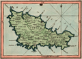 | Details | Luffman, John | 1800 |
| Antique map Belle Isle, France engraved for Luffman's Select Plans |
|
Luffman, John |
|
| 1800 |
| LOC:0 |
| $0.00 | Luffman--John | Antique-map-Belle-Isle--France-engraved-for-Luffman-s-Select-Plans | SOLD
<br></br>
Neat antique engraved map of the Island of Belle Isle in the Bay of Biscay in France. With the headlands shown of Talifer Point, Corigan Point, Poulains Point, Grand Village Point and many more. Many small cities and towns are identified as well as a citadel near the town of Palais.
<br></br>
Key political divisions noted by Luffman include the four parishes of Sauzon, Locmaria, Bangor, and Palais.
<br></br>
From "Luffman's Select Plans of the Principal Cities, Harbors, Forts etc. in the World". Engraved and published by John Luffman, No. 28 Little Bell Alley, Coleman Street, August 1, 1800. Volume I, #54.
<br></br>
Luffman also provided similar engravings at about the same time for J.T. Serres' "The Little Sea Torch: or, True Guide for Coasting Pilots." Serres translated the Little Sea Torch from an earlier illustrated coasting pilot guide, based on Bougard's "Le petit flambeau de la mer", first published in 1684. Serres added his own magnificent views of headlands, ports, lighthouses, landmarks, topography, coastal scenes, ships and harbor entrances.
<br></br>
John Luffman (1751-1821) began his career as an engraver, trained by John Bayly, a noted map engraver in the Goldsmiths' Company, producing a fine map of Antigua, where he had resided in 1787 and 1789. Luffman shared the same sad fate as many publishers and was declared bankrupt on 9th March, 1793. Moving forward Luffman was more cautious and produced small format atlases and handy-sized maps of the theatres of war, principal towns and cities and battle-plans relating to the Wars of the French directorate and the subsequent Napoleonic War. |
| 4849 | 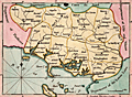 | Details | Luffman, John | 1800 |
| Antique map Morbihan, Brittany, France Luffman's Select Plans |
|
Luffman, John |
|
| 1800 |
| LOC:0 |
| $0.00 | Luffman--John | Antique-map-Morbihan--Brittany--France-Luffman-s-Select-Plans | SOLD
<br></br>
An original antique engraved and hand-colored map of the department of Morbihan in Brittany (Bretagne) near the Bay of Biscay, France. Includes the islands of Belle Isle, Hoat, Hoedic, and Dumet. Key cities include Vannes, Rochefort, Quiberon, Auray, and Bernard.
<br></br>
From "Luffman's Select Plans of the Principal Cities, Harbors, Fortresses, etc. in the World". Engraved and published by John Luffman, No. 28 Little Bell Alley, Coleman Street, February 1, 1800. Volume I. #30.
<br></br>
Luffman also provided similar engravings at about the same time for J.T. Serres' "The Little Sea Torch: or, True Guide for Coasting Pilots." Serres translated the Little Sea Torch from an earlier illustrated coasting pilot guide, based on Bougard's "Le petit flambeau de la mer", first published in 1684. Serres added his own magnificent views of headlands, ports, lighthouses, landmarks, topography, coastal scenes, ships and harbor entrances.
<br></br>
John Luffman (1751-1821) began his career as an engraver, trained by John Bayly, a noted map engraver in the Goldsmiths' Company, producing a fine map of Antigua, where he had resided in 1787 and 1789. Luffman shared the same sad fate as many publishers and was declared bankrupt on 9th March, 1793. Moving forward Luffman was more cautious and produced small format atlases and handy-sized maps of the theatres of war, principal towns and cities and battle-plans relating to the Wars of the French directorate and the subsequent Napoleonic War. |
| 4852 | 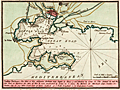 | Details | Luffman, John | 1801 |
| Antique British chart of Toulon Harbor, France |
|
Luffman, John |
|
| 1801 |
| LOC:13 |
| $250.00 | Luffman--John | Antique-British-chart-of-Toulon-Harbor--France | Antique large scale chart of Toulon Harbor, France by John Luffman from 1801.
<br><br>
A fine plan of the Little Road and the Great Road of Toulon. Depth soundings and marked anchorages fill the chart on the way south to the Mediterranean Sea. Shows numerous defensive features including Fort St. Louis, Malgue Fort, numerous towers, and two powder magazines (outside town walls).
<br></br>
As described by Luffman: <div class="indenttextblock">
"Toulon Harbour. The mole of this celebrated harbour was begun by Henry 4 and finished by Louis 13. The arsenal A. and the new port or harbor for Men of War B. were constructed by Louis 14. C. shews the harbour for merchant ships, coasters, etc. Toulon City is 217 miles south-east of Paris. Latitude 43.7 North. Longitude 5.37 East from London."
</div>
</BR>
From "Luffman's Select Plans of the Principal Cities, Harbors, Forts etc. in the World". Engraved and published by John Luffman, No. 28 Little Bell Alley, Coleman Street, Cheapside, London. September 1, 1801. Volume I, Number 9.
<br></br>
John Luffman (1751-1821) began his career as an engraver, producing a very large and fine map of Antigua, where he had resided in 1787 and 1789. That map was published by Luffman to accompany his 'A Brief Account of the Island of Antigua', 1788." Luffman shared the same sad fate as many publishers and was declared bankrupt on 9th March, 1793. Moving forward Luffman was more cautious and produced small format atlases and handy-sized maps of the theatres of war, principal towns and cities and battle-plans relating to the Wars of the French directorate and the subsequent Napoleonic War. |
| 5287 | 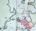 | Details | Luffman, John | 1801 |
| Port Louis, France harbor chart engraved for Luffman's Select Plans |
|
Luffman, John |
|
| 1801 |
| LOC:7 |
| $185.00 | Luffman--John | Port-Louis--France-harbor-chart-engraved-for-Luffman-s-Select-Plans | Copper-plate engraved chart or map of Port Louis, France. Louis XIV established the French East India Company or Compagnie française pour le commerce des Indes orientales, at Port-Louis in 1664. in 1769, unable to maintain itself financially, the Company was liquidated.
<br></br>
The chart shows the walled town of Port Louis and the Citadel, now home to the Musée de la Compagnie des Indes. Along the roadstead: St. Catherines, two un-named forts, the Island of St. Michael; Querco Point and Bangor Point.
<br></br>
Description at the bottom reads in part:
<div class="indenttextblock">
"Port Louis, a town & fort in the Dept. of Morbihan 2 miles S. of l'Orient and 282 W. by S. of Paris."
</div>
<br />
From "Luffman's Select Plans of the Principal Cities, Harbors, Forts etc. in the World". Engraved and published by John Luffman, No. 28 Little Bell Alley, Coleman Street, October 1, 1801. Vol II. Number 25.
<br></br> |
| 1058 | 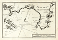 | Details | Allezard, Jean Joseph | 1804 |
| Early French Port Plan of Cannes and Antibes France |
|
Allezard, Jean Joseph |
|
| 1804 |
| LOC:4 |
| $150.00 | Allezard--Jean-Joseph | Early-French-Port-Plan-of-Cannes-and-Antibes-France | Small antique port plan of a portion of the Côte d'Azur on the Mediterranean coast of southeatern France. Coverage includes Cannes and Cap d'Antibes, the peninsula between the Bay of Cannes to the south-west and the Baie des Anges to the north east.
<br></br>
Plate 20 of Allezard's atlas "Recueil de 163 des principaux Plans des Ports et Rades de la Mediterranée, dont 40 ont été derniérement publiés par Jean Joseph Allezard ancien Capitaine de Marine." Essentially this plan is a later copy of a plan first laid down by Michelot and Bremond around 1727 and later published by Roux. |
| 208 |  | Details | Michelot and Bremond | 1805 |
| Portulan de la Mer Méditerranée |
|
Michelot and Bremond |
|
| 1805 |
| LOC:0 |
| $600.00 | Michelot-and-Bremond | Portulan-de-la-Mer-Méditerranée | Very rare antique edition of this book of sailing directions by Henry Michelot whose earliest career with Louis XIV's Corp des Galeres (Galley Corps) dates to approximately 1675. This edition published in French by Jean Mossy in 1805 is updated with sailing directions for the Levant coast and Greek Archipelago not found in the original 1703 edition. <BR> </BR>
For the collector of <a rel="nofollow" href= "/MichelotBremondBackground.aspx">Michelot and Bremond sea charts</a> this volume provides fascinating background and depth into their early works. 596 pages including an index. Includes a preface by Mossy. No maps or illustrations (as issued). |
| 644 | 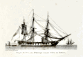 | Details | Baugean, Jean-Jerome | 1814 |
| American Frigate at Anchor |
|
Baugean, Jean-Jerome |
|
| 1814 |
| LOC:1 |
| $225.00 | Baugean--Jean-Jerome | American-Frigate-at-Anchor | Attractive and scarce original nautical antique copperplate engraving of an American frigate by the French artist Jean-Jerome Baugean. Published circa 1814 the small plate shows an American frigate at anchor. According to John Harland: <dir class="indenttextblock">"The mizzen topsail is set, and the wind-sail just seen abaft the fore mast was used in hot weather to ventilate the gundeck; the crew have washed their hammocks, and these have been triced up to dry… This is one of the smaller frigates, possibly the Boston." (Harland, John. "The Maritime Prints of J.J. Baugean", Chatham Publishing. London, 2000. p. 40.) </dir>
</BR>
This antique engraving is from a series of 72 fine engravings of merchant and naval vessels created and engraved by Baugean (1764-1830) in the series: "Collection de Toutes les Especes de Batimens de Guerre et de Batimens Marchard." Baugean's engravings are notable for their accurate and detailed depictions of ship construction and rigging. |
| 645 | 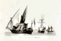 | Details | Baugean, Jean-Jerome | 1814 |
| French Mediterranean Privateers |
|
Baugean, Jean-Jerome |
|
| 1814 |
| LOC:1 |
| $195.00 | Baugean--Jean-Jerome | French-Mediterranean-Privateers | Original antique nautical copper-plate engraving of three French privateer ( corsair ) vessels. Published circa 1814 by Jean-Jerome Baugean this authentic small plate shows three Mediterranean privateers at anchor. According to John Harland: <dir class="indenttextblock">"Baugean does not comment on the rigs, but from right to left they are a schooner, tartane, and what seems to be an armed pinque. The last is airing both its lateen and square sails. This ensemble emphasizes the fact that although northern European rigs, like the schooner, were to be found in the Mediterranean, there were a number of rigs - and indeed hull forms - unique to that sea." (Harland, John. "The Maritime Prints of J.J. Baugean", Chatham Publishing. London, 2000. p. 98.) </dir>
</BR>
This antique engraving is from a series of 72 fine engravings of merchant and naval vessels created and engraved by Baugean (1764-1830) in the series: "Collection de Toutes les Especes de Batimens de Guerre et de Batimens Marchard." Baugean's engravings are notable for their accurate and detailed depictions of ship construction and rigging. |
| 286 | 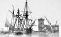 | Details | Baugean, Jean-Jerome | 1814 |
| Navire Danois embarquant de Blocs de Marbre |
|
Baugean, Jean-Jerome |
|
| 1814 |
| LOC:0 |
| $0.00 | Baugean--Jean-Jerome | Navire-Danois-embarquant-de-Blocs-de-Marbre | Sold<BR></br>
A gem! This small, highly-detailed antique copperplate engraving by the French artist Jean-Jerome Baugean published circa 1814 depicts a Danish sailing vessel at anchor loading large blocks of marble from a lighter. The mizzen sail is set, presumably to help maintain the ship's position while loading.<BR> </BR>
This engraving is from a series of 72 fine antique engravings of merchant and naval vessels created and engraved by Baugean (1764-1830)- "Collection de Toutes les Especes de Batimens de Guerre et de Batimens Marchard." Baugean's engravings are notable for their accuracy and detail. |
| 290 |  | Details | Baugean, Jean-Jerome | 1814 |
| Chebec espagnol a voiles latines, courant vent largue. |
|
Baugean, Jean-Jerome |
|
| 1814 |
| LOC:0 |
| $150.00 | Baugean--Jean-Jerome | Chebec-espagnol-a-voiles-latines--courant-vent-largue- | This item would make an exceptional gift for a loved one !
<br><br>
Below please find a sweet original antique copperplate engraving with very fine detail printed in 1814. A superlative example by the French artist Jean-Jerome Baugean on creamy laid with a tight platemark as was the practice. Published circa 1814 the engraving shows a Chebec (alt. 'zebec') underway in a light breeze.
<br><br>
Xebec's are small vessels similar in size to a frigate and characterized by 2 or 3 lateen sails and a prominent overhanging bow and stern.
<br><br>
This engraving is from a series of 72 fine antique engravings of merchant and naval vessels created and engraved by Baugean (1764-1830)- "Collection de Toutes les Especes de Batimens de Guerre et de Batimens Marchard." Baugean's engravings are notable for their accuracy and detail. |
| 291 |  | Details | Baugean, Jean-Jerome | 1814 |
| Vaisseau de Ligne Francais, au Plus Pres du vent, le Perroquet de Fougue Sur le Mat |
|
Baugean, Jean-Jerome |
|
| 1814 |
| LOC:1 |
| $185.00 | Baugean--Jean-Jerome | Vaisseau-de-Ligne-Francais--au-Plus-Pres-du-vent--le-Perroquet-de-Fougue-Sur-le-Mat | This small, highly-detailed antique copperplate engraved print by the French artist Jean-Jerome Baugean published circa 1814 details a French ship-of-the-line close to the wind. <BR> </BR>
This engraving is from a series of 72 fine antique prints of merchant and naval vessels created and engraved by Baugean (1764-1830)- "Collection de Toutes les Especes de Batimens de Guerre et de Batimens Marchard." Baugean's engravings are notable for their accuracy and detail. |
| 295 |  | Details | Baugean, Jean-Jerome | 1814 |
| Bombardes Francaises de la Mediterranee |
|
Baugean, Jean-Jerome |
|
| 1814 |
| LOC:1 |
| $175.00 | Baugean--Jean-Jerome | Bombardes-Francaises-de-la-Mediterranee | This antique, small, highly-detailed copperplate engraving by the French artist Jean-Jerome Baugean published circa 1814 details two French bombardes (or bomb-vessels) at sea. A bombarde relied on mortars mounted near the bow with high elevation to lob exploding shells down on the enemy. Early French bomb-vessels had two mortars placed side-by-side in the bow that were aimed while at anchor by pulling in or letting out a spring anchor. The heavy armament explains the wide and somewhat barge-like bow depicted in this engraving. The extra width would have been needed to support the weight of the mortars.<BR> </BR>
This engraving is from a series of 72 fine antique prints of merchant and naval vessels created and engraved by Baugean (1764-1830) in the series: "Collection de Toutes les Especes de Batimens de Guerre et de Batimens Marchard." Baugean's engravings are notable for their accurate and detailed depictions of ship construction and rigging. |
| 320 | 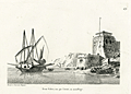 | Details | Baugean, Jean-Jerome | 1814 |
| Demi Galere, vue par l'avant , au mouillage |
|
Baugean, Jean-Jerome |
|
| 1814 |
| LOC:1 |
| $225.00 | Baugean--Jean-Jerome | Demi-Galere--vue-par-l-avant---au-mouillage | This small, highly-detailed antique copperplate engraving by the French artist Jean-Jerome Baugean published circa 1814 details a demi-galère (small galley) at anchor. The demi-galere pictured carried 5 cannon, mounted at the bow and about 9 oars on each side. A full-sized galley might be armed with a dozen or more cannon and be fitted with banks of 24 oars to both port and starboard.
<BR> </BR>
This demi galere is noteworthy because of the three masts with lateen sails. The additional mizzen near the stern would have increased the vessel's maneuverability.
<BR> </BR>
This engraving is from a series of 72 fine engravings of merchant and naval vessels created and engraved by Baugean (1764-1830) in the series: "Collection de Toutes les Especes de Batimens de Guerre et de Batimens Marchard." Baugean's engravings are notable for their accurate and detailed depictions of ship construction and rigging. |
| 325 |  | Details | Baugean, Jean-Jerome | 1814 |
| Sloop vu par l'avant; Prame venant de mouiller |
|
Baugean, Jean-Jerome |
|
| 1814 |
| LOC:1 |
| $125.00 | Baugean--Jean-Jerome | Sloop-vu-par-l-avant;--Prame-venant-de-mouiller | "Sloop vu par 'l'avant" is a highly-detailed nautical antique copperplate engraving by the French artist Jean-Jerome Baugean. Published circa 1814 the small plate shows a sloop from the bow under full sail after it has passed a pram at anchor (Fr. Prame). In this context the pram is a large 3-masted flat bottom ship with about 10 cannon.<BR> </BR>
This antique engraving is from a series of 72 fine engravings of merchant and naval vessels created and engraved by Baugean (1764-1830) in the series: "Collection de Toutes les Especes de Batimens de Guerre et de Batimens Marchard." Baugean's engravings are notable for their accurate and detailed depictions of ship construction and rigging. |
| 407 |  | Details | Jenkins, James | 1816 |
| Capture of La Vestale |
|
Jenkins, James |
|
| 1816 |
| LOC:0 |
| $0.00 | Jenkins--James | Capture-of-La-Vestale | SOLD
<br></br>
The hand-colored antique aquatint depicts the capture near Rochefort of the 36 gun French frigate Vestale by the British 38 gun 5th rate vessel Clyde. On paper watermarked "Whatman 1812".
<BR> </BR>
One of 55 plates from Jenkins' famous volume: "The Naval Achievements of Great Britain, From the Year 1793 to 1817" after a painting by T. Whitecombe. Attribution at bottom of plate reads: "Published Aug 1st, 1816 at 48 Strand for J. Jenkins' Naval Achievements". |
| 408 |  | Details | Jenkins, James | 1816 |
| Capture of La Tribune |
|
Jenkins, James |
|
| 1816 |
| LOC:50 |
| $0.00 | Jenkins--James | Capture-of-La-Tribune | SOLD
<br><br>
Antique hand-colored engraving depicts the capture of the 44-gun French frigate La Tribune by HMS Unicorn on June 8, 1796.
<br><br>
One of 55 hand-colored aquatint plates from Jenkins' famous volume: "The Naval Achievements of Great Britain, From the Year 1793 to 1817" after a painting by T. Whitecombe. Attribution at bottom of plate reads: "Published Feb 1st, 1817 at 48 Strand for J. Jenkins' Naval Achievements". |
| 972 |  | Details | Pinot, Charles | 1816 |
| Antique manuscript map of Bagueau and Port-Cros in France's îles d'Hyères |
|
Pinot, Charles |
|
| 1816 |
| LOC:0 |
| $900.00 | Pinot--Charles | Antique-manuscript-map-of-Bagueau-and-Port-Cros-in-France-s-îles-d-Hyères | One of a kind, 200 year-old manuscript topographic map of the French Mediterranean island Île de Bagueau and the north coast of Port-Cros island. Signed and dated within by Ch[arles] Pinot, Director of Fortifications in 1816.
<br></br>
Topograhic detail shown through faint contour lines in pencil with benchmarks and elevation stated in several locations. Three cannon batteries noted in red on Bagueau. On Port-Cros, Pinot noted these features: Presqu'ile de Malalenge, Plage de Jeannet, Batterie Sud, and Chateau Ruine.
<br></br>
Both Île de Bagueau and Port-Cros belong to the îles d'Hyères, a group of four Mediterranean islands off the village of Hyères in the Var department of south-east France. Île de Bagueau at 45 hectares is the smallest of the four islands in the group. Port-Cros, at 650 hectares, is a French national Park.
<br></br>
Signed in French in faint ink: Toulon, 5th October, 1816 The Colonel and Director of Fortifcations Charles Pinot. A note in ink below the title begins: "La partie de terrain marquee…".
<br></br>
With a faint red oval overstamp of the "DEPOT de la Direction des Fortifications DE TOULON" |
| 671 |  | Details | Anonymous | 1820 |
| Blank shipping document from du Roveray and Company of Havre |
|
Anonymous |
|
| 1820 |
| LOC:1 |
| $195.00 | Anonymous | Blank-shipping-document-from-du-Roveray-and-Company-of-Havre | Rare blank maritime shipping document dates from 1820's from du Roveray & Co. of Havre, France. With an image of a sailing ship at upper left. This template shipping document was designed so that the shipper could enter pertinent standard contractual information in the blank areas: ship's name, master's name, destination, recipients name, freight rate, number of bills of lading, and date.
<br></br>
The engraved document begins <div class="indenttextblock">"Shipped in good order and well-conditioned by DU ROVERAY & Co. of Havre; in and upon the good [blank] called the [blank] whereof is Master, for this present voyage [blank] now riding at anchor in the Port of Harve, & bound for [blank] to say [blank] …"<div> |
| 34 | 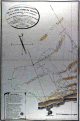 | Details | Beautemps-Beaupre, Charles-Francois | 1820 |
| Reconnoissance Hydrographique de la Cote Nord de France, Dunkerque |
|
Beautemps-Beaupre, Charles-Francois |
|
| 1820 |
| LOC:0 |
| $575.00 | Beautemps-Beaupre--Charles-Francois | Reconnoissance-Hydrographique-de-la-Cote-Nord-de-France--Dunkerque | This large-scale antique hydrographic chart of the town and environs of Gravelines is a fine example of the work of Charles-François Beautemps-Beaupré (1766-1854). Beautemps-Beaupre was one of the earliest hydrographers to use isobaths to represent water depth. In this chart he uses differently colored isobaths to represent three depth categories : less than 10 feet ; between 10 and 16 feet; and between 17 and 24 feet. This detail along with numerous soundings demonstrates Beautemp-Beaupre's dedication to his profession, and is the reason he is sometimes referred to as the 'father of French hydrography'.
<br><br/>
Date of 1802 is consistent with a dedication to vice-admiral F.E. de Rosily who served as Directeur of the Depot Generale de la Marine from 1795-1805. |
| 35 |  | Details | Beautemps-Beaupre, Charles-Francois | 1820 |
| Dunkerque |
|
Beautemps-Beaupre, Charles-Francois |
|
| 1820 |
| LOC:0 |
| $975.00 | Beautemps-Beaupre--Charles-Francois | Dunkerque | This scarce large-scale antique hydrographic chart of the town and environs of Dunkirk is a fine example of the work of Charles-François Beautemps-Beaupré, often referred to as the "Father of French Hydrography". Covering a stretch of coast from Mardick to Zuycoote the chart is focused almost entirely on the offshore areas.
<BR> </BR>
Beautemps-Beaupré (1766-1854), considered to be the father of modern French hydrography, was one of the earliest hydrographers to use colored isobaths to represent water depth. In this carefully colored chart he uses differently colored isobaths (light orange tones) to represent three depth categories : less than 10 feet ; between 10 and 16 feet; and between 17 and 24 feet. This detail along with hundreds of soundings demonstrates Beautemp-Beaupres' dedication to his profession.
<BR> </BR>
Not dated but another example from same series is dated to 1802. This fine example was likely published ca 1820 as part of "Le Pilote Francais", Beautemps-Beaupre's six folio-volume atlas comprised of 613 sheets of charts and plans. With the logo of the French Depot de la Marine. |
| 36 | 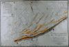 | Details | Beautemps-Beaupre, Charles-Francois | 1820 |
| Reconnoissance Hydrographique de la Cote Nord de France |
|
Beautemps-Beaupre, Charles-Francois |
|
| 1820 |
| LOC:0 |
| $0.00 | Beautemps-Beaupre--Charles-Francois | Reconnoissance-Hydrographique-de-la-Cote-Nord-de-France | SOLD<br></br>
Attractive large-scale antique copper-plate hydrographic chart of the French coast from Gravelines to Ostende by Charles-François Beautemps-Beaupré. Oriented with North at top of page indicated by a large compass circle (with shadow); surveyors lines and several sets of rhumb lines.
<BR> </BR>
Beautemps-Beaupre (1766-1854) was one of the earliest hydrographers to use isobaths to represent water depth. In this carefully colored chart he uses differently colored isobaths (light orange tones) to represent three depth categories : less than 10 feet ; between 10 and 16 feet; and between 17 and 24 feet. This detail along with hundreds of soundings demonstrates Beautemp-Beaupres' dedication to his profession, and suggests why he is considered by some to be the father of French hydrography.
<BR> </BR> |
| 222 | 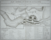 | Details | Tardieu, Ambroise | 1822 |
| Plan General du Port de Boulogne |
|
Tardieu, Ambroise |
|
| 1822 |
| LOC:89 |
| $175.00 | Tardieu--Ambroise | Plan-General-du-Port-de-Boulogne | Finely engraved map / plan of Boulogne harbor engraved by Ambroise Tardieu in 1822 (dated) with disposition of marine forces during the Campaign of 1803. Focus is on dozens of ships docked both in the river and in the hemispherical 'Bassin de la Flotille'. Bottom contains detailed French text keyed to locational numbers on the map; for example "Depot des Gardiens de la Chaine de Entrée". This antique copperplate engraving probably from one of a six-volume series published by General Count Mathieu Dumas: "Précis des evénemens militaires. Recueil de plans et de cartes pour servir à l'intelligence des opérations militaires décrites dans le texte."<BR> </BR>
Amboise Tardieu (1788 - 1841) was descended from a family of famous French engravers that included Pierre Alexandre Tardieu and Nicolas Tardieu, a 17th century coppersmith from Paris. Tardieu is sometimes confused with his famous son Auguste Ambroise Tardieu, France's top expert in forensic pathology. |
| 718 | 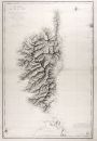 | Details | Blondeau, Alexandre | 1831 |
| Antique French Sea Chart of Corsica |
|
Blondeau, Alexandre |
|
| 1831 |
| LOC:66 |
| $850.00 | Blondeau--Alexandre | Antique-French-Sea-Chart-of-Corsica | Large antique copper-plate engraved nautical chart of the French island of Corsica ( Corse )and nearby islands: Isle of Asinara, Bonifacio Strait, Capraia Island, Elba ( Elbe ), and northern Sardinia ( Sardaigne ). Coverage includes the towns of Bonifacio, Ajaccio ( the birthplace of Napoleon Bonaparte ), Calvi, Ile Rousse, St Florent, Port Vecchio, and many more.
<br></br>
This splendid original French sea chart is a fine example of mid eighteenth-century nautical cartography. A heavy impression and admirable detailed engraving of the mountainous relief of the island are accompanied by a wealth of detail not only of the coastal regions but inland as well.
<br></br>
Issued by the French Depot Generale de la Marine in 1831 (dated within) after surveys by the Depot de la Guerre in 1824, and by Captain Hell in 1822, 1823, and 1824. Engraved by Alexandre Blondeau of France's Depot de la Guerre. At bottom right is the circular logo with anchor of the Depot General de la Marine. Number 232. Price when issued two Francs. |
| 1387 | 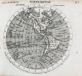 | Details | Michel fils | 1834 |
| Atlas Universal a small French pocket Atlas. |
|
Michel fils |
|
| 1834 |
| LOC:0 |
| $250.00 | Michel-fils | Atlas-Universal-a-small-French-pocket-Atlas- | Atlas Universel with 30 small steel-engraved maps. Followed by a 24-page section of definitions and explanations of geographic locations in French. With original paper covers.
<br></br>
Published by Michel fils aine [the elder brothers] , Paris, Rue de la Hachette, No. 24 |
| 319 |  | Details | Depot de la Marine | 1836 |
| Plan du port de Barfleur et de ses environs |
|
Depot de la Marine |
|
| 1836 |
| LOC:0 |
| $355.00 | Depot-de-la-Marine | Plan-du-port-de-Barfleur-et-de-ses-environs | Highly detailed antique nautical chart of the harbor and town of Barfleur, France and the surrounding coastline extending about 1.5 French mille marine to the north and south. Roads, fields, and very rocky offshore topography near the coast are depicted with great detail and relief. This graphic treasure captures the state of that stretch of coastline as it was in 1832 from the Pointe de Barfleur with its lighthouse to the north, past Anse Crabet and dozens of small islets, beyond the Plateau de Antiqueires and Plateau de Moulard to Anse de Landemer south of Barfleur. Nearby villages depicted include Monfarville, Quenanville, and Gatteville.<BR> </BR>
Manuscript notation of a cannon battery at the far east end of Barfleur harbor includes four red lines extending into the sea presumably marking the prospective firing angle and range of those cannon protecting the navigational channel. Circular stamp of Depot General de la Marine. Number 848. Price 2 francs. |
| 4773 |  | Details | Compagnie du chemin de fer de Paris a la Mer | 1838 |
| Earliest map of the Paris au Havre railway in France |
|
Compagnie du chemin de fer de Paris a la Mer |
|
| 1838 |
| LOC:88 |
| $800.00 | Compagnie-du-chemin-de-fer-de-Paris-a-la-Mer | Earliest-map-of-the-Paris-au-Havre-railway-in-France | Rare antique lithographed map of the Paris to Havre Railway (Paris a la mer) made before construction and during the first French Railway boom. About the earliest available advertisement for French railroads (chemin de fer) and one of 10 competing railway proposals submitted to the French Parliament between 1835 and 1847.
<br></br>
With a fine detailed drawing of a 1838 coal-powered steam engine chugging along with wagons carrying passengers, horses and cattle, and agricultural goods. Gentleman passengers in top hats casually observe the countryside from seats atop the passenger car. Workers in the coal car appear appropriately fatigued.
<br></br>
The first locomotive-powered railway in France, the Paris to St. Germain opened in 1837 followed immediately by a lack of interest in financing railway projects by the large French banks. This map advertised the potential of the Paris to Havre railway, probably an attempt to reach capital sources outside the French banking industry. Shows two train routes. The first route, in blue, represented the "Chemin par les Plateaux" while the uncolored set of parallel lines denoted the "Project par la Valee."
<br></br>
Lithograph on laid paper with Blauw watermark. Lithographed by Delarue, Rue Notre Dame Victoires 16.
<br></br>
Grace's Guide to British Industrial History notes the leadership of the rail project was attributable to William Mackenzie and Thomas Brassey. In 1840 Mackenzie and Brassey
<div class="indenttextblock">
"began railway works in France, and elsewhere. These included the greater part of the Paris and Rouen Railway; the whole of the Rouen and Havre Railway, including the stations and the maintenance of way of both lines; the line from Rouen to Dieppe, all under Joseph Locke, and George Neumann. " (Source: https://www.gracesguide.co.uk/Brassey_and_Mackenzie)
</div> |
| 316 |  | Details | Depot de la Marine | 1839 |
| Plan de l'embouchure de la Seine (environs du Harve) |
|
Depot de la Marine |
|
| 1839 |
| LOC:0 |
| $225.00 | Depot-de-la-Marine | Plan-de-l-embouchure-de-la-Seine--(environs-du-Harve) | Large antique chart covering the mouth of the Seine river with Villerville on the South bank and Le Havre and St. Adresse on the North bank. Le Havre fortress shown completely encircled with Vauban-type defensive walls. Locations of cannon batteries added in manuscript. This antique nautical chart has been profusely annotated in manuscript apparently by a member of the military or a military engineer. Numerous pencil notations in left and right margins with bearings. Red pen used to draw lines radiating from cannon batteries to delineate the expected range and line of fire. Numerous soundings. Circular stamp of Depot General de la Marine. No. 892. Price 2 francs. |
| 317 | 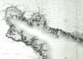 | Details | Depot de la Marine | 1839 |
| Carte Particuliere des Cotes de France (Cherbourg) |
|
Depot de la Marine |
|
| 1839 |
| LOC:0 |
| $210.00 | Depot-de-la-Marine | Carte-Particuliere-des-Cotes-de-France-(Cherbourg) | Attractive antique nautical chart (1839 ) of the environs around Cherbourg, France including Cape Hague and Cape Levi. Includes villages of Biville, Vauville, Auderville, Tonneville, Omonville, Greeville, Flottemanville, Querqueville, Henneville, Equerdeville, Toulaville, and Bretteville, and Cherbourg. The locations of several forts are noted and the cannon batteries and forts are named via script annotations in black ink. <BR> </BR>
This antique chart has been profusely annotated in manuscript apparently by a member of the military or a military engineer. Numerous pencil notations in left margin and top with bearings. Red pen used to draw lines radiating from cannon batteries to delineate the expected range and line of fire. Numerous soundings. Circular stamp of Depot General de la Marine. Price 2 francs. |
| 318 | 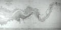 | Details | Depot de la Marine | 1841 |
| Carte Particuliere des Cotes de France (Cours de la Seine) |
|
Depot de la Marine |
|
| 1841 |
| LOC:0 |
| $375.00 | Depot-de-la-Marine | Carte-Particuliere-des-Cotes-de-France-(Cours-de-la-Seine) | Antique nautical chart of the Seine River with numerous soundings for the navigational channel. Villages include Guerbaville, Bliquetuit, Caudebec, Villequier, Aizier, Vieux Port, St. Aubin, Berville sur-mer, St. Opportune, Bouquelon, Conteville, St. Nicolas de-la-Taille, La Cerlangue, St. Vigor, Fiquetfleur, Tancarville, Rogerville, Gonfreville, St. Sauveire, Fatouville, and Honfleur. <BR> </BR>
Lower quarter of the nautical chart is dedicated to extensive remarks and a tide table. Numerous soundings and windmills are noted (moulin). Circular stamp of Depot General de la Marine. Number 949. Price 2 francs. |
| 326 | 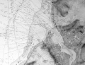 | Details | Depot de la Marine | 1842 |
| Plan du port de Boulogne |
|
Depot de la Marine |
|
| 1842 |
| LOC:0 |
| $225.00 | Depot-de-la-Marine | Plan-du-port-de-Boulogne | Antique nautical chart published in 1842 covering the French port of Boulogne and nearby coastline. Circular stamp of Depot General de la Marine. |
| 4739 | 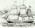 | Details | Barbey, Isidore-Théodore | 1845 |
| Very rare broadsheet. Barbey clipper-ship advertisement. Havre, France |
|
Barbey, Isidore-Théodore |
|
| 1845 |
| LOC:62 |
| $3,500.00 | Barbey--Isidore-Théodore | Very-rare-broadsheet--Barbey-clipper-ship-advertisement--Havre--France | Very rare and historical clipper-ship advertisement for ships (Paquebots / Clippers) owned by <b>Isidore-Théodore Barbey</b> of Havre, France. Barbey's ships were known for their <b>white hulls</b>. This important broadsheet likely dates to the earliest shipping enterprise owned by Barbey, before incorporation in 1855. Not found online. Lithographed by Lenormand, Rue de l'Hopital 37, Havre.
<br></br>
The goal of the advertisement was to convey the luxuriousness of traveling on Barbey's ships by including a detailed plan for the Grande Chambre with tiny four-person staterooms and a single watercloset for all passengers. Housed below the "dunette", a high, exposed deck at the stern of the ship, was an antechamber, an office, dining table and cabins for two captains, and 30 passengers. For reference to key points in the ship's construction the lithograph shows the location for the mizzen mast (mat d'artimon) and the rudder post (gouvernail).
<br></br>
<div class="indenttextblock">
In 1839 Isidore-Théodore Barbey founded in Le Havre a shipping company for trade with Valparaíso and Lima. The company prospered, with six ships in 1850, and was incorporated as <b>Compagnie d'Armement Maritime in 1855</b>. Passenger ships operated on scheduled lines from Le Havre to Valparaíso, Vera Cruz, La Plata, Bahia and Reunion. The magnificent, white-hulled ships were nicknamed "white clippers". The shipowner never insured his ships and reinvested the saved premiums [likely the reason the ship does not appear in Lloyd's extensive records]. In 1857, Barbey owned 39 vessels and had another 34 in construction.</div></BR>
<img src="/PageImages/Barbey_Flag.jpg" alt="Barbey clipper-ship house flag." width="100" border="2" hspace="10" vspace="10" align="middle"> Barbey flag: White with black letters.
<br></br>
(Source: Flags of the World. https://fotw.info/flags/fr~hfarm.html") |
| 346 | 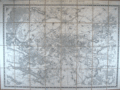 | Details | Depot General de la Guerre | 1857 |
| Environs de Paris. |
|
Depot General de la Guerre |
|
| 1857 |
| LOC:0 |
| $220.00 | Depot-General-de-la-Guerre | Environs-de-Paris- | Antique folding map of Paris, France and its environs by the French war department originally published in 1839. This revised edition from 1857 has an emphasis on the Seine river and includes Versailles. Backed with coarse brown linen, the map is divided into eight horizontal sections and 4 vertical sections and folds to a compact 6" x 8 3/4".<BR> </BR>
The antique map is annotated at bottom with a circular, blue seller's stamp from "E. Andriveau-Goujon - Geographe" and an oval blind-stamp by the "Depot de la Guerre". Scale 1:40,000. When folded the front cover contains a decorative black and white sticker from E. Andriveau-Goujon Geographe, editeur, Rue du Bac 21, Paris . The sticker details the many specialties of his shop including: globes, spheres, Atlas de Choix, and cartes de parties du monde. |
| 1110 |  | Details | Imagerie de P. Didion | 1860 |
| Mid-Nineteenth Century French Fencing Certificate |
|
Imagerie de P. Didion |
|
| 1860 |
| LOC:9 |
| $250.00 | Imagerie-de-P--Didion | Mid-Nineteenth-Century-French-Fencing-Certificate | "Diplôme d'une spécialité d'escrime". Two-color lithographed and hand-colored blank fencing certificate or diploma. In this certificate the combatants are using sabre-like weapons with no hand guard, perhaps wooden practice weapons . Similar martial-arts certificates were issued for a number of French sword and stick fencing ( escrime ) styles. Common all these 19th century 'brevet' is that onloookers, presumably including signatories to the certificate, view the mock combat in military regalia surrounded by emblems and mottos of the French state. Other simlar brevet exist for pointe ( foil ), bâton, and canne.
<br></br>
Publisher's attribution reads: Imagerie de P. Didion, a Metz. Dehalt Successeur. |
| 6383 |  | Details | Anonymous | 1866 |
| Manuscript cadastral map of the Commune de Lovagny |
|
Anonymous |
|
| 1866 |
| LOC: |
| $100.00 | Anonymous | Manuscript-cadastral-map-of-the-Commune-de-Lovagny | manuscript map of the commune of Lovagny in the Haute-Savoie department in the Auvergne-Rhône-Alpes region in south-eastern France. |
| 23 |  | Details | James Imray and Son | 1868 |
| The Coasts of France, Spain and Portugal (Blueback) |
|
James Imray and Son |
|
| 1868 |
| LOC:0 |
| $750.00 | James-Imray-and-Son | The-Coasts-of-France--Spain-and-Portugal-(Blueback) | Very attractive, imposing, and desirable 140+ year old blueback nautical chart of the Atlantic coast of Europe. Contains the blue stamp from the firm of "Imray 1869". Coverage includes the Strait of Gibraltar and western Mediterranean. This wide antique nautical chart of the West coat of Europe would have been useful to any navigator sailing eastward as it covers all the approaches to the Mediterranean, Bay of Biscay, English Channel and the Bristol and Irish Channels.<BR> </BR>
A six- foot working blueback nautical chart by Imray that has seen its time at sea and exudes history. You can almost smell the salt air! Several manuscript navigator's tracks plotted in pencil include notation: "8th day July 1877 from (illegible) to Falmouth 133 days out". 9 insets including rivers Tagus, Douro and Gironde. Lighthouses indicated in red.<BR> </BR>
On verso is original yellow publishers label from James Imray and Son with price of 10s 6d. Also on verso is a sellers label from "D. Eggert and Sons, manufacturers and importers of chronometers, fine watches, nautical instruments, charts, books, &c. 127 Pearl Street, New York between Wall Street and Old Slip."
<BR> </BR>
For more information on the evolution of blueback charts we recommend this book by Susanna Fisher:
<a target="_blank" style="color:#9BAFCB" href="http://www.regattapress.com/The_Makers_of_the_Blueback_Chart.html">The Makers of Blueback Charts.</a>
<BR> </BR> |
| 4738 |  | Details | Favereau, Charles-Eugene | 1875 |
| Manuscript Notebook of Vice Admiral Charles Favereau with Charts |
|
Favereau, Charles-Eugene |
|
| 1875 |
| LOC:2001 |
| $1,500.00 | Favereau--Charles-Eugene | Manuscript-Notebook-of-Vice-Admiral-Charles-Favereau-with-Charts | <img src="\PageImages\Charles_Eugene_Favereau_Vice_Amiral.jpg" alt="French Vice-Admiral Charles Eugene Favereau" width="150" Align="left" style="margin:1em">Rare and desirable notebook including much tight French script and eight MS charts and port plans from the early training cruises of Vice-Admiral Charles Eugene Favereau (1856-1936), then an aspirant (Midshipman) in the French Navy.
<br></br>
Favereau entered Naval School in October, 1872 and after three years was an aspirant in October, 1875. Favereau first served on the training ship ALEXANDER and then on the GAULOISE in the Mediterranean and in 1877 on the MAGICIENNE in the Pacific. (Source: http://ecole.nav.traditions.free.fr/officiers_favereau_charles.htm)
<br></br>
During a long career in the French Navy Favereau served as Lieutenant Commander, Commander, and Captain aboard the cruiser NAIADE, the battleships FORMIDABLE, REPUBLIC, ST.LOUIS and BAYARD. On June 30, 1910 Favereau was promoted to contre-Admiral, and on January 28, 1914 to Vice Admiral . He left the Navy in 1918.
<br></br>
Favereau's eight ink manuscript harbor plans and charts include ports on the Mediterranean north coast of Africa, the Azores, Spain, and the islands of Madeira.
<div class="indenttextblock">
a) Port d'Alger (Algiers) </BR>
b) Plan du Mouillage de Mers al Kebir</BR>
c) Partie est de Madere (East portion of the Madeira archipelago)</BR>
d) Plan de Funchal et de la Baie</BR>
e) Western Azores (Sao Jorge, Faial, and Pico)</BR>
f) Plan of Fayal (Faial) and Baie de Horta</BR>
g) Faial-Pico channel</BR>
h) Vigo estuary and Cies Islands</BR>
</div>
</BR>
Text of about 80 pages in French. Small drawings of devices and machinery related to weapons and artillery. With small notations in red at several points believed to be grades or acknowledgement of completion by an instructor. |
| 4754 |  | Details | Haussmann, Georges-Eugène | 1880 |
| Urban Architect Haussmann Wife's Calling Card |
|
Haussmann, Georges-Eugène |
|
| 1880 |
| LOC:0 |
| $100.00 | Haussmann--Georges-Eugène | Urban-Architect-Haussmann-Wife-s-Calling-Card | Arguably, no one is more responsible for the distinctive Parisian street plan of today than urban architect Georges-Eugène Haussmann. This artifact is Haussmann's wife's ( Louise Octavie de Laharpe 1807-1890; m. 1838) calling card from the latter part of the 19th century. With manuscript notations to the recipient on the recto. |
| 5199 | 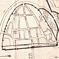 | Details | Anonymous | 1880 |
| Manuscript plan of Chalon-sur-Saône, France |
|
Anonymous |
|
| 1880 |
| LOC:77 |
| $175.00 | Anonymous | Manuscript-plan-of-Chalon-sur-Saône--France | Fine manuscript pen and ink plan ca. 1880 titled: "Plan de deux enceintes primitives de Chalon sur Saone." Show the ancient city with the two ancient walls or "enceintes" at the village of Chalon-sur-Saône, France. Notes the location of many interesting sites including the "gibet" (gibbet) or post used as a gallows or place of execution.
<br></br>
With a unperforated red stamp bearing three circles ( the coat of arms of Chalon sur Saone) above the French medal Legion d'Honneur surmounted by a crown. Napoleon I awarded the Legion d'Honneur to the town of Chalon sur Saone in 1815 in recompense for their support during his Austrian campaign.
<br></br>
Top is oriented to the northeast. Shows the Saone river with bridges at right. |
| 877 | 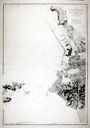 | Details | Depot de la Marine | 1881 |
| Antique Port Plan of Marseille, France in Provence |
|
Depot de la Marine |
|
| 1881 |
| LOC:58 |
| $875.00 | Depot-de-la-Marine | Antique-Port-Plan-of-Marseille--France-in-Provence | Old French large-scale chart of the port and harbor of Marseilles, France in the Provence region. The geographical extent of this antique chart extends from Cap Janet trending southward past the Iles d'Endoume ending at the beach area of Plage de Mont-Redon. Coverage includes the small island of Chateau d'If and eastern portions of Ile Ratonneau and Iles du Frioul .
<br></br>
Key features that are noted by name include: Chateau Talabot, tour St. Michel, the Nouvelle Cathedrale, Anse des Catalans, les Accoules, Hotel des Villes, and the Bassin de Carenage. Shows two lighthouses marking the entrance to the old harbor which is protected by Fort St. Jean and Fort St. Nicolas.
<br></br>
Published by France's Official Hydrographical Agency the <b> Depot des Cartes et Plans de la Marine</b>. Date of last correction: 1881. |
| 756 | 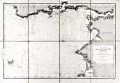 | Details | Depot de la Marine | 1907 |
| Antique nautical chart of Brittany Coast near the Vilaine River |
|
Depot de la Marine |
|
| 1907 |
| LOC:0 |
| $425.00 | Depot-de-la-Marine | Antique-nautical-chart-of-Brittany-Coast-near-the-Vilaine-River | Antique chart of the west coast of France from the Anse de Cornaud and Pointe du Grand Mont southward to le Croisic. First published in 1826, this chart of Brittany includes part of the Department of Morbihan, and the mouths of the Penerf and Vilaine rivers. The chart is updated as of 1907. Settlements and habitations covered include Cornaud, Saint-Gildas-de-Rhuys, Chateau de Suscino (en ruins), Damgan, Port de Billiers, Penestin (Pennetin), Mesquer, Piriac-sur-Mer, la Turballe, Guerande, Clie, and Saille. The chart extends westward to include the Ile d'Hoedic and many surrounding smaller islets of the greater and lesser Cardinaux Islands.
<br></br>
Very extensive and minute detail of the shoreline and near shore areas with elevation denoted by fine hachuring. Hundreds of individual structures are placed accurately. Thousands of soundings with isobath contour lines and navigational hazards would have aided the coastal navigator in the area.
<br></br>
This is a early 20th century linen-mounted folding chart, an updated edition of a chart first published by France's Depot de la Marine in 1826. This sea chart is based on the original surveys conducted in 1820 and 1821 under the supervision of Charles-François Beautemps-Beaupré (1766-1854), considered to be the father of modern French hydrography. Linen verso is printed via letterpress with "De La Pointe du Grand-Mont AU CROISIC. Entrée de la Vilaine." |
| 758 | 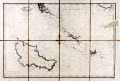 | Details | Depot de la Marine | 1908 |
| Antique nautical chart of Quiberon Bay with islands of Belle-Ile, Hoedic, and Houat |
|
Depot de la Marine |
|
| 1908 |
| LOC:66 |
| $425.00 | Depot-de-la-Marine | Antique-nautical-chart-of-Quiberon-Bay-with-islands-of-Belle-Ile--Hoedic--and-Houat | Antique lithographed chart of waters offshore of the west coast of France from southwest of the village of Saint Gildas and the Pointe du Grand-Mont. First published in 1826, this chart near the Brittany coast in western France includes the peninsula of Presqu'ile Quiberon and is the edition of January 1903 published with the latest updates in 1908.
<br></br>
Very extensive and minute detail of the shorelines and near shore areas with elevation denoted by fine hachuring. Thousands of soundings with isobath contour lines and navigational hazards would have aided the coastal navigator in the area. At the far right a particularly dangerous area for navigators, the "Plateau de la Recherche" is highlighted in brown
<br></br>
This is a early 20th century linen-mounted folding chart, an updated edition of a chart first published by France's Depot de la Marine in 1827. This lithographed nautical chart is based on the original surveys conducted during 1820 and 1821 under supervision of Charles-François Beautemps-Beaupré (1766-1854), considered to be the father of modern French hydrography. Beautemps-Beaupre was one of the earliest hydrographers to use isobaths to represent water depth.
<br></br>
Linen verso is printed via letterpress with "BELLE-ILE Entrée de la Baie de Quiberon. Iles Houat et Haedik". Number 135. |
| 639 |  | Details | Montaut, Ernest | 1909 |
| First Crossing of the English Channel by Air |
|
Montaut, Ernest |
|
| 1909 |
| LOC:0 |
| $875.00 | Montaut--Ernest | First-Crossing-of-the-English-Channel-by-Air | Original hand colored pochoir-process lithographed poster by Ernest Montaut commemorating the first crossing of the English Channel by a heavier-than-air aircraft in July 1909 by French aviator and engineer Louis Charles Joseph Blériot. The flight lasted less than 37 minutes. Bleriot won a prize of £1,000 for his achievement from the Daily Mail newspaper. Very good condition.
<br><br/>
Published by Mabileau, Paris. Copyright 1909.
<br><br/>
The 'pochoir' process used to color the lithograph is defined as: "French for 'stencil', used of prints colored by hand with the help of stencils to mask out the areas where each colour is not required". (Gascoigne, Bamber. "How to Identify Prints. Thames and Hudson, 1991. Page 206. ) |
| 4798 | 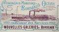 | Details | Companie Maritime Bordeaux Ocean | 1910 |
| Companie Maritime Bordeaux Ocean 1910 Route Map |
|
Companie Maritime Bordeaux Ocean |
|
| 1910 |
| LOC:88 |
| $280.00 | Companie-Maritime-Bordeaux-Ocean | Companie-Maritime-Bordeaux-Ocean-1910-Route-Map | Antique map by the French firm <b>Companie Maritime Bordeaux Ocean</b> of the Garonne River from the town of Bordeaux following the river to its mouth near Royan. A source of commercial and geographical information about the Garonne River, Gironde Department and specifically the Bordeaux wine region of France during the first decade of the 20th century. A scarce folding booklet with cover depicting a sidewheel steamboat bearing the company flag with "B.C."
<br></br>
Shows these vineyards: Chateau Margaux, Chateau Larose Trintaudon, Chateau Pichon Longueville, Chateau Latour, Chateau Moulin d'Armailhac, Château Loudenne, and Chateau Sainte Barbe. Many other landmarks are shown pictorially including the Tour de Cordouan, Port de Mortagne, Port Maubert, and Place des Quinconces. Verso incudes timetable, and many advertisements for local maritime-related firms.
<br></br>
From La Bastide and Bordeaux north to the river's confluence with the Atlantic Ocean. |
| 4831 | 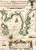 | Details | Sella, Andrea | 1930 |
| Rare Ex-libris la Rade du Gourjan Antibes for Sella |
|
Sella, Andrea |
|
| 1930 |
| LOC:13 |
| $0.00 | Sella--Andrea | Rare-Ex-libris-la-Rade-du-Gourjan-Antibes-for-Sella | SOLD<br></br>
Not 1727, but an early 20th century ex-libris or bookplate for Andreae (Andre') Sella after a early 18th-century nautical port plan by Henri Michelot and Laurens Bremond of the Cap d'Antibes. Circa 1930s.
<br></br>
Engraved by Georges Gorvel, active during the 1920's and 1930's.
<br></br>
Apparently from André Sella, manager of the Grand Hotel on Cap d'Antibes who had a large collection of documents and objects from the Napoleonic era. In 1952, the Navy granted him permission to use a site on the Cap d'Antibes site to house his growing collection. More than a decade later André Sella accepted the post of manager of the Association of Friends of Maritime Museums.
<br></br>
André Sella donated his collection to the Maritime Museum. With financial aid from the Antibes council, the museum grew and became the Napoleonic Museum (Le musée Napoléonien), opened on May 30, 1964. |
| 453 | 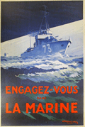 | Details | Theunissen, A. | 1930 |
| Engagez-vous dans la Marine |
|
Theunissen, A. |
|
| 1930 |
| LOC:0 |
| $650.00 | Theunissen--A- | Engagez-vous-dans-la-Marine | Large, dynamic, post-WWI recruiting poster for the French navy dated to 1930. Depicts a fast patrol boat or destroyer. <BR> </BR>
Lithograph, signed in the plate by A. Theunissen, followed by the symbol of an anchor which is one of the privileges accorded those artists who have been appointed as official "Peintre de la Marine". Theunissen was given that honor in 1925 by the French Minister of Defense in recognition of his artistic work for the French Navy or maritime subjects . Published by Devambez, Paris. 1930. |
| 4841 |  | Details | Belanske, William E. | 1930 |
| Charts related to Vanderbilts circumnavigation in 1930 Belanske |
|
Belanske, William E. |
|
| 1930 |
| LOC:300 |
| $0.00 | Belanske--William-E- | Charts-related-to-Vanderbilts-circumnavigation-in-1930-Belanske | SOLD<br><br>One lot of six (6) charts, each well-marked recto and verso with blue ink stamps of William E. Belanske, two with MS annotations. Belanske was an artist and former curator of William K. Vanderbilt's Marine Museum on his estate near Centerport, Long Island. These charts are related to the 1931 - 1932 circumnavigation of the world by William K. Vanderbilt II aboard the Motor Ship Alva with Belanske aboard recording flora and fauna.
<br></br>
Two charts (Tuamotu and Marquesas) heavily annotated presumably in the hand of Belanske and based on research before the cruise. Topics include tattooing, sex morality, cannibalism, food, hunting, local personalities and notable historic events.
<div class="indenttextblocksingle">
Near Takaroa: "Where Woronick the Parisian jewel expert bought the wonderful pearl that he made a fortune with. Mostly monsoons in these islands."
<br></br>
At Makatea: "Makatea is famous as the rendezvous of the infamous Marquesan half-caste Boraki the most picturesque pirate that ever sailed the South Pacific"
</div>
</br>
Recto with Navy Department ink stamp for the corrections date. On the verso each chart bears the blue ink hand-stamp "Property of William E. Belanske" and numerous manuscript identifiers. The six charts include:
<div class="indenttextblocksingle">
<ul style="list-style-type: circle;">
<li><b>Tuamotu Archipelago from a Survey of the U.S. Ex Ex in 1839.</b> 1872 / 1930. U.S. Navy. No. 77. 35"x24" MS Annotations. </li>
<li><b>The Marquesas Islands. From French Surveys in 1881 and 1882.</b> 1899 / 1930. U.S. Navy. No 1797. 21"x28". MS Annotations.</li>
<li>Port Phaeton and Approaches. 1902 / 1930 U.S. Navy. No. 1992. 27"x20".</li>
<li>East Coast of Viti Levu. 1914 / 1930. U.S. Navy. No. 2859. 38" x25"</li>
<li> Whitsunday Island to Percy Isles. 1924 / 1930. U.S. Navy. No 3455. 39"x25"</li>
<li>Borabora Island. 1902 / 1930 U.S. Navy. No. 2005. 22"x26".</li>
</ul>
</div> |
| 2534 | 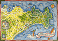 | Details | Syndicat d'Initiative d'Antibes Juan Les-Pins | 1949 |
| A fine pictorial promotional map for Antibes Juan Les-Pins |
|
Syndicat d'Initiative d'Antibes Juan Les-Pins |
|
| 1949 |
| LOC:0 |
| $0.00 | Syndicat-d-Initiative-d-Antibes-Juan-Les-Pins | A-fine-pictorial-promotional-map-for-Antibes-Juan-Les-Pins | SOLD<br></br>
Very colorful and visually stimulating map of the town and resort at Juan Les-Pins in the commune of Antibes on France's Mediterranean Côte d'Azur. Situated west of the town of Antibes, in the past it had been an area with many stone pine trees (pins), where the inhabitants of Antibes used to go for a promenade, for a picnic in the shadow of the stone pine trees or to collect tree branches and cones for their stoves. Verso is blank.
<br></br>
Created by Vic Raymon. |
| 4743 | 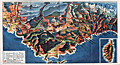 | Details | Societe Nationale des Chemins de Fer Francais | 1950 |
| Attractive map of France's Cote d'Azur |
|
Societe Nationale des Chemins de Fer Francais |
|
| 1950 |
| LOC:77 |
| $80.00 | Societe-Nationale-des-Chemins-de-Fer-Francais | Attractive-map-of-France-s-Cote-d-Azur | Attractive birds-eye view of the coast of the <b>Cote D'Azur</B> in Provence, France stretching from Lyons, France past Monaco. With an inset of the Island of Corsica. Published as a fine folding brochure in 1950 by the Societe Nationale des Chemins de Fer Francais (S.N.C.F.). Red lines represent the railways owned by the French National Railways (SNCF) in in the mid 20th century. |
| 436 | 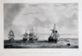 | Details | Gudin, Baron Theodore | 1950 |
| Combat d'une vaisseau Francais contre quatre vaisseaux Anglais |
|
Gudin, Baron Theodore |
|
| 1950 |
| LOC:9 |
| $140.00 | Gudin--Baron-Theodore | Combat-d-une-vaisseau-Francais-contre-quatre-vaisseaux-Anglais | Depicts a battle in 1655, near Majorca, between a French ship of 30 cannon "Le Persee" and a group of 4 English vessels. The Persee, captained by the Chevalier de Valbelle, a Knight of Malta, was attacked by a group of 4 English warships in retribution for his previous action in which he attacked and boarded an English vessel after the English vessel demanded a salute. (Source: England in the Mediterranean: A Study of the Rise and Influence of British …, Sir Julian Stafford Corbett, Google Books. 1917)<BR> </BR>
This fine work from the original 19th century plate, is a 20th century reprint by the Louvre of an etching and engraving on steel plate by Chavane. Subject matter is based on a painting by French Marine Painter Baron Theodore Gudin (1802-1880 ) in 1846. <BR> </BR>
With the circular embossed stamp of "Musee Louvre Chalcographie". La Chalcographie du Louvre is a repository of more that 13,000 plates from the Louvre's archives, housed upstairs above the Louvre's Paris galleries . Upon request visitors can have a engraving produced from one of those original plates by master printers on museum-quality paper. |
| 6794 |  | Details | Poisson, O. | 1950 |
| Fine mid-century lithographed pictorial map of Nice, France |
|
Poisson, O. |
|
| 1950 |
| LOC:89 |
| $165.00 | Poisson--O- | Fine-mid-century-lithographed-pictorial-map-of-Nice--France | Original, attractive, lithographed pictorial map of Nice, France by O. Poisson ca. 1950. Printed by Impremerie Bonfant & Rampelberg, Nice. Shows the Velodrome, Parc Chambrun, Conservatoire de Musique, Eglise Russe, Casino Municipal, and much more. Recto with German text about the city.
<br><br>
Located on the beautiful French Riviera, Nice is a captivating city that offers a unique blend of natural beauty, rich history, and vibrant culture. With its stunning coastline, palm-lined promenades, and crystal-clear waters, Nice is a paradise for beach lovers and outdoor enthusiasts. The iconic Promenade des Anglais, stretching along the azure waters of the Mediterranean, is a bustling hub where visitors can soak up the sun, enjoy leisurely walks, or indulge in delicious cuisine at the numerous beachside cafes and restaurants. Beyond the beaches, Nice boasts a charming Old Town with its narrow streets, colorful buildings, and lively markets, providing a glimpse into the city's rich heritage and offering a delightful blend of local shops, boutiques, and authentic French cuisine. |
| 3678 |  | Details | British Admiralty Hydrographical Office | 1953 |
| Chart of Channel Islands and Coast of France |
|
British Admiralty Hydrographical Office |
|
| 1953 |
| LOC:0 |
| $180.00 | British-Admiralty-Hydrographical-Office | Chart-of-Channel-Islands-and-Coast-of-France | An authentic 20th-century British nautical chart of the Channel Islands and the nearby Normandy coast of France . This large chart includes the islands of Jersey, Guernsey, Alderney, Sark and some smaller islands. Last corrections are dated to 1953.
<br></br>
Logo of the British Hydrographical Office at top of the title block. Number 2669. |
| 4851 |  | Details | Anonymous | 1954 |
| Birds-eye view of the French Riviera |
|
Anonymous |
|
| 1954 |
| LOC:88 |
| $195.00 | Anonymous | Birds-eye-view-of-the-French-Riviera | The recto features a highly detailed birds-eye view and map of the French coast, extending from St. Tropez and St. Raphael to Menton. It highlights various towns, such as <b>Grasse, Cannes, Juan-les-Pins, Antibes, Nice, and Monaco</b>. Additionally, it offers a helpful route map that indicates the names and distances of cities along two travel segments for a journey from St. Raphael to Menton:
<br><br>
<div class="indenttextblocksingle">
<ol>
<li>From Nice to St. Raphael via the Corniche de l'Esterel</li>
<li>From Nice to Menton along the Corniches</li>
</ol>
</div>
<div id="0" align="center">
<a title="French Riviera"></a>
<img id="3" src="/ZoomifyImages/SC_4851/SC_4851_detail.jpg" alt="Old birds-eye view and road map of the French Riviera." width="340"/> <br><small>Nice-Cannes-Menton et les routes du littoral.</small>
</div><br>
Although labeled "Ed 54" on the cover, suggesting a publication date of 1954, the included photographs appear to be from the early 1940s. The map's top section displays the names of mountain peaks in the background, and all text is in French.
<br><br>
On the verso, you'll find extra routes, photographs, and descriptions of various sights and attractions. After reviewing the brochure, it's clear that this area is an excellent candidate for a future vacation destination.
<br><br>
Published by France's Direction générale du Tourisme under the Ministry of Public Works, Transport, and Tourism, this edition is identified as "Ed. 54." |
| 451 |  | Details | Decaris, Albert | 1958 |
| Salon de la Marine |
|
Decaris, Albert |
|
| 1958 |
| LOC:50 |
| $195.00 | Decaris--Albert | Salon-de-la-Marine | Very decorative medium-format original two-color poster shows <strong>Neptune</strong> grasping a trident while cradling a sailing vessel. The poster was produced to promote the Salon de la Marine, held in 1958 at the <strong>Paris Musee de la Marine.</strong> The Salon is an event held at the National Marine Museum in Paris to display maritime art by invited artists and by artists named as "Peintre de la Marine" or official marine painter.
<BR> </BR>
By <strong>Albert Decaris</strong>, one of France's top engravers in the 20th century. Decaris was honored with the post of the official painter of the Marine Française in 1962. |
| 1047 |  | Details | Dovarinoff, Jean | 1973 |
| Pictorial map of St. Barths with roads and beaches |
|
Dovarinoff, Jean |
|
| 1973 |
| LOC:0 |
| $0.00 | Dovarinoff--Jean | Pictorial-map-of-St--Barths-with-roads-and-beaches | SOLD<br></br>
Decorative, large, pictorial map of the Caribbean island of Saint Barthelemy (Saint Barths or St. Barts). Dated within to 1971/1973. St. Barts is a French territory located in the Caribbean Sea about 25 miles southeast of St. Martin. The capital of St. Barts is Gustavia. Details many of the fine beaches on the island including: Anse a Colombier, Anse de Grande Saline, Anse de Grand Cul de Sac, Anse de Lorient, and Anse du Gouvereur.
<br></br>
This scarce pictorial map of St. Barths, out of print for many decades, is decorated with sailing ships, fanciful sea creatures, pirates, and mermaids. A legend at far right explains the cartographic conventions used on this map. French text. Attribution reads: "Dressee par Jean Dovarinoff, le 30.3.1971 a l'anse des cayes, Saint Barthelemy, Guadeloupe." |