| | Thumbnail | | Creator | Date | Title / Author / Date / Location | Price | | | Description |
| 404 | 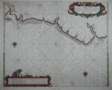 | Details | Roggeveen, Arent | 1675 |
| Paskaert vande Cust van Westindien |
|
Roggeveen, Arent |
|
| 1675 |
| LOC:51 |
| $4,500.00 | Roggeveen--Arent | Paskaert-vande-Cust-van-Westindien | This rare antique chart is the earliest available detailed sea-chart of this portion of the Guyana coastline. On this fine Dutch foundational sea chart from ca. 1675 coverage stretches from Rio Soronama (Suriname River) and Paramaribo, Suriname in the east to the west past Rio Demerary (Demerara River) and Georgetown, Guyana. Fort Paramaribo is the sole noted habitation, reflecting both the early date of the chart and the fort's importance for trading. The course of the Demerara River is shown with soundings to past St. Iohannes Island (St. John's Island), about 15 miles from the river's mouth.<br></BR>
This old nautical chart appears in the First Part of the Burning Fen or "Het Brandende Veen" created by Arent Roggeveen and published by <a rel="nofollow" href="/creator/Goos--Pieter/" >Pieter Goos</a> . Dr. C. Koeman described the significance of this work as of the same order as Waghenaer's Der Spieghel der Zeevaerdt: <br>
<dir class="indenttextblock">"The First Part of the Burning Fen rates as one of the most important printed Pilot Books. The First Part of the Burning Fen, published by Pieter Goos in 1675, is the first pilot book containing charts of the Central American coasts and islands that ever appeared in print."</dir> </BR>
Unlike Waghenaer, Arent Roggeveen was not a sea captain but rather a trained land-surveyor who taught navigation in the town of Middelburg to pilots of the Dutch West India Company which was headquartered there. Roggeveen likely had access to manuscript charts from Guyana and possibly to early Spanish portolan charts through his connections with the West India Company.<BR> </BR> |
| 849 | 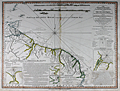 | Details | Rochette, Louis S. | 1783 |
| Chart of the Northern Atlantic Coast of South America |
|
Rochette, Louis S. |
|
| 1783 |
| LOC:51 |
| $250.00 | Rochette--Louis-S- | Chart-of-the-Northern-Atlantic-Coast-of-South-America | Antique nautical chart of the coast of South America including Venezuela, the island of Trinidad and Tobago, Guyana, Suriname, and Brazil. Four inset plans: "The Entrances of the Rivers Essequibo and Demerari", Entrance to the River Berbice", "Surinam River from the Dutch", and "Port of Cayenne from the French". From surveys conducted by Captain Edward Thompson, commander of the Hyaena
<br></br>
This chart was printed in 1783 by William Faden, English cartographer and map publisher, who after the death of Thomas Jefferys succeeded Jefferys to the title of "Geographer to the King". Carries the following endorsement at bottom: "Approved by the Chart Committee of the Admiralty" which would have been a seal of approval important to both the buyers and to Faden. Faden's charts were preferred by the Chart Committee of the Admiralty, appointed beginning in 1807 to select suitable charts for the fleet.
<div class=indenttextblock>"They selected two hundred of the least unsatisfactory, half of them Admiralty charts, either already published or in course of preparation, and the remainder from the commercial publishers. An impressive 50% of the one hundred privately published charts came from William Faden who published many surveys from naval officers so probably offered more charts of areas frequented by warships…" (Fisher, Susanna. The Makers of Blueback Charts: A History of Imray Laurie Norie and Wilson Ltd. Imray Laurie Norie and Wilson Ltd. 2001. p. 11)</div>
</br>
The chart is annotated with numerous fascinating notes and comments about the local geography and inhabitants. For example: <div class=indenttextblock> "Orinoco Islands Covered with palm trees and overflowed from the middle of January to the middle of July. They are inhabited by the Guaraunas and Tivitivas whose houses are built on piles driven in the mud or among branches of the trees".</div>
and,
<div class=indenttextblock> "Runaway negroes with whom peace was made in September 1761".</div> |
| 4904 | 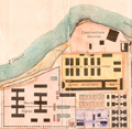 | Details | Anonymous | 1912 |
| Plan General de St. Laurent de Maroni French Guyana Papillon |
|
Anonymous |
|
| 1912 |
| LOC:88 |
| $600.00 | Anonymous | Plan-General-de-St--Laurent-de-Maroni-French-Guyana-Papillon | Unrecorded plan for the <b>French Penal Colony at St. Laurent</b> along the Maroni River in French Guyana. Established by Napoleon III in 1850, for almost 100 years St. Laurent de Maroni was the main penal establishment of French Guiana. Rare.
<br></br>
Henri Charriere, the famous prisoner <b>Papillon</b> of the eponymously named film starring Steve McQueen and Dustin Hoffman, was a prisoner at St. Laurent de Maroni. The prison can be found on the map at top center surrounded by a wall . The prison complex included a old hospital and a new hospital, a transportation camp, the "Quartier Disciplinaire. The hospital was among the inmates favorites. Many prisoners faked illnesses just to be sent to the hospital so that they could plan their escape more easily.
<br></br>
The town of Saint-Laurent-du-Maroni proper was founded on 16 March 1880. St. Laurent was a penal town whose inhabitants were nearly all guards or liberated prisoners. The hospital was built in 1912, and the prison itself closed in 1946, the same year the whole colonial penal system was abolished. |