| | Thumbnail | | Creator | Date | Title / Author / Date / Location | Price | | | Description |
| 496 | 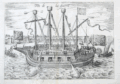 | Details | Hogenberg, Franz | 1585 |
| Fin de La Guerre (warship) |
|
Hogenberg, Franz |
|
| 1585 |
| LOC:1 |
| $295.00 | Hogenberg--Franz | Fin-de-La-Guerre-(warship) | Copperplate-engraved oblique profile of the Dutch fighting ship "Fin de la Guerre". This large fortress-like, four masted ship saw action at the battle of Antwerp in 1585. The engraving is notable because the ship is much like a U.S. Civil war monitor or WWI battleship with a design emphasis on firepower and protection for the fighting forces. The vessel is shown firing cannon as it is attacked by smaller vessels including at least one small galley or galliot. Lacks the explanatory text found in other versions of the print… possibly a later version. Attributed to Hogenberg and Michael Aitzinger. |
| 5131 | 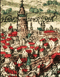 | Details | Baudartius, Willem | 1616 |
| Hantwerpia |
|
Baudartius, Willem |
|
| 1616 |
| LOC:13 |
| $150.00 | Baudartius--Willem | Hantwerpia | Antique copper-plate engraving of a battle between the Spanish and the Dutch during the 80 Years War. The 15-gun Black Galley of Dordrecht defeated eight Spanish ships on the Schelde / Scheldt river at Antwerp, 29 November 1600.
<br></br>
Published in Amsterdam by M. Colin de Thovoyon in 1616 in 'Les guerres de Nassau' by Willem Baudartius. |
| 984 | 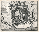 | Details | Anonymous | 1680 |
| Old map of Ostend, Belgium. |
|
Anonymous |
|
| 1680 |
| LOC:7 |
| $60.00 | Anonymous | Old-map-of-Ostend--Belgium- | Small anonymous antique map of Ostend / Ostende / Oostende, Belgium (ca. 1680) which today is located in the province of West-Flanders. The old map shows numerous water features, redoubts, and defensive walls with bastions surrounding the city.
<br></br>
A legend at top left is keyed alphabetically to several major features including: the Kerck (Church), Kyasenest, Strand, Nieuwe Haven, and city gates (Poorte). This map bears a strong resemblance to a map of Ostende published by Blaeu in 1647. |
| 300 | 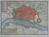 | Details | de Fer, Nicolas | 1700 |
| Anvers |
|
de Fer, Nicolas |
|
| 1700 |
| LOC:7 |
| $350.00 | de-Fer--Nicolas | Anvers | Small antique map /plan of the historic town of Antwerp (Anvers), Belgium ca. 1700. Shows the walled and moated city of Antwerp along the Scheldt (Escaut) river with an additional fortress ( Citadelle ) attached on the upstream end of the city. A general street plan is supported by a 20+ item legend identifying key points in the city and surrounding area.<BR> </BR>
This antique copperplate-engraved map was produced toward the end of the 17th century by the well known French geographer and cartographer, Nicolas de Fer (1646 - 1720). De Fer was a prolific producer of maps and prints who among other honors, was appointed as official geographer to the Spansh King in 1702. |
| 933 | 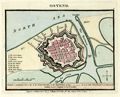 | Details | Luffman, John | 1803 |
| Antique plan of Ostend, Belgium |
|
Luffman, John |
|
| 1803 |
| LOC:7 |
| $145.00 | Luffman--John | Antique-plan-of-Ostend--Belgium | Small, neat, antique plan of the Belgian coastal town of <b>Ostend</b> shown surrounded by water on 3 sides and by Vauban-style defensive walls with numerous bastions. Published 1804 by <b>John Luffman</b> in "Select Plans of the Principal Cities, Harbours, Forts etc. in the World." Luffman (1776-1820) was a London goldsmith, engraver, and publisher.
<br></br>
Description of the town at bottom reads: <div class="indenttextblock">"Ostend, a considerable port and city of the French Republic in the department of Lys. It is 22 miles NE of Dunkirk and 10 W. of Bruges. Latitude 51.14 N. Longitude 5.0 E. of London." </div>
</br>
Luffman shows thick, double defensive walls around the town with a street plan. Includes the harbor at the east end and Key Creek to the south. A legend at left is keyed to several important locations including: the town house; the great church; St. Martins; the great square; the new market, the key gate; the west gate; the beast market; and coffers (piers). The plan is drawn at low tide with the coffers high above a large expanse of exposed beach.
<br></br>
Publisher's attribution at bottom margin reads: <div class="indenttextblock">Engraved and Published Nov 1, 1803 by J. Luffman, No. 28 Little Bell Alley, Coleman Street, London.</div> |
| 932 | 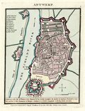 | Details | Luffman, John | 1804 |
| Antique plan of Antwerp, Belgium |
|
Luffman, John |
|
| 1804 |
| LOC:7 |
| $200.00 | Luffman--John | Antique-plan-of-Antwerp--Belgium | <div class="indenttextblock">"Antwerp, fine city of France in the department of the Scheldt; heretofore the capital of the Austrian Brabant, and once the mistress of the commerce of Europe. Latitude 51.13 North. Longitude 4.29 East from London." </div> So reads the description of this neat antique plan of the walled town of <b>Antwerp, Belgium</b>. Published 1804 by <b>John Luffman</b> in "Select Plans of the Principal Cities, Harbours, Forts etc. in the World." Luffman (1776-1820) was a London goldsmith, engraver, and publisher.
<br></br>
Luffman shows double defensive walls around the rather large town with a street plan. Includes the Citadel at the southern end of town and two forts across the Scheldt river along the "Dyke of Flanders".
A legend at left is keyed to several important locations including: The Cathedral; Town House; Fort Isabella; St. James; St. George; St. Walburg; St. Andren; St. Michael; the Exchange; and Meer Street. Two additional forts are identified as Terre de Flanders and Fort St. Laurent.
<br></br>
Publisher's attribution at bottom margin reads: <div class="indenttextblock">"Engraved and Published Feb 1, 1804 by J. Luffman, No. 28 Little Bell Alley, Coleman Street, London."</div> |
| 589 |  | Details | Stratford, J. | 1810 |
| Sketch of the River Scheldt from Flushing to Antwerp |
|
Stratford, J. |
|
| 1810 |
| LOC:0 |
| $165.00 | Stratford--J- | Sketch-of-the-River-Scheldt-from-Flushing-to-Antwerp | Detailed. antique hydrographic map or chart of a portion of the Scheldt (Escaut) River. After the earlier work by French hydrographer Beautemps Beaupre. Named features include: Antwerp, Ft. Kruys Schans, Ft. St. Philip, Ft. Maria, Ft. Liefkenshoek, Ft. Rammekins, Fort Lillo, Ter Neuse, Santvliet, Biervliet, Middleburg, and Flushing. Numerous soundings (in feet), lighthouses, sand banks, forts and defensive structures are noted.
<br></br>
The antique chart is dated within as published March 24, 1810. Paper carries watermark of "1806". London. J. Stratford No. 112 Holborn Hill. |
| 561 |  | Details | Gyselynck, F and E | 1840 |
| Ghent Ship Brokers Porcelain Trade Card |
|
Gyselynck, F and E |
|
| 1840 |
| LOC:0 |
| $80.00 | Gyselynck--F-and-E | Ghent-Ship-Brokers-Porcelain-Trade-Card | Antique ornately printed and decorated 19th century Belgian porcelain trade card for B. Kreps, A. Van Engelen, & F. Leys. Gend.”, Office and Company of Ship Brokers and Builders ("Courtiers de navires, Scheeps-Makelaars, Shiffsmakler").
Elaborate typography and Illustrations include: at top a ribbon design with words in Flemish describing the firm’s services; the firm’s name within a central cartouche design of seashell and anchor, illustrations of sailing ships at either side; and firm’s street address in Ghent beneath; printed in metallic ink and blue on shiny white card stock (hence name Porcelain Card). Name of Lithographer in Ghent lower left: "F & E Gyselynk". |
| 1174 | 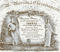 | Details | Marsily and Christiansen | 1845 |
| Trade card for Antwerp ship chandlers Marsily and Christiansen |
|
Marsily and Christiansen |
|
| 1845 |
| LOC:0 |
| $0.00 | Marsily-and-Christiansen | Trade-card-for-Antwerp-ship-chandlers-Marsily-and-Christiansen | SOLD
<br></br>
Rare porcelain trade card for Antwerp ship chandlers Marsily and Christiansen. On coated card stock. English text touts " Marine Stores of all descriptions" including:
<div class="indenttextblock">
<ul style="list-style-type: circle;">
<li>Charts</li>
<li>Instruments</li>
<li>Sheathing, copper and zinc</li>
<li>Sugars</li>
<li>Gin</li>
<li>Wines for exportation</li>
<li>Assortment of fowling pieces and pistols.</li>
<li>Chain cables and anchors</li>
</ul>
</div>
The process of coating paper stock was developed in England, but was used most extensively in continental Europe, particularly Belgium. The 1840s and 1850s saw the advent of the Belgian "porcelain cards," sumptuously designed and beautifully printed trade cards whose high-gloss finish had the look of porcelain.
<br></br>
The firm Marsily and Christiansen was located at 1st Dock Antwerp. (Date is calculated as 20 years after the 1825 publishing date of a Norrie nautical chart where the Marsily and Christiansen seller's stamp is present.) |
| 5219 |  | Details | International Navigation Congress | 1908 |
| Report of the 11th meeting of the International Navigation Congress |
|
International Navigation Congress |
|
| 1908 |
| LOC:2001 |
| $100.00 | International-Navigation-Congress | Report-of-the-11th-meeting-of-the-International-Navigation-Congress | Scarce booklets (24) of reports for the 11th meeting of the International Navigation Congress or Association Internationale Permanente de Congres de Navigation, held in St. Petersburg, Russia during 1908. Some reports with folding plates. Authors of these reports represent a diverse set of countries including but not limited to: Germany, England, Belgium, Russia, France, Italy, and the United States.
<br></br>
Contents include booklets in French or English text (some with engineering or hydrographic plates). The topics are related to five broad areas of interest:
<div class="indenttextblocksingle">
<ul style="list-style-type: circle;">
<li>Fishing ports and harbors for coastal maritime trade.</li>
<li>Economic and engineering studies for Inland maritime ports.</li>
<li>Port construction on sandy beaches.</li>
<li>General conditions for secure maritime navigation.</li>
<li>Hydrographic exploration of the seas.</li>
</ul>
</div>
Hard cover binder secured by string closures with 24 reports, each staple bound with paper covers. Some booklets bear the oval stamp of the Liverpool Engineering Society. |
| 4756 | 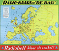 | Details | Bell Telephone | 1938 |
| Early Radiobell Persuasive Sales Advertisement |
|
Bell Telephone |
|
| 1938 |
| LOC:57 |
| $200.00 | Bell-Telephone | Early-Radiobell-Persuasive-Sales-Advertisement | Map of Europe ca. 1938 centered on Antwerp. Purpose of the map is to promote the sales of the "Radiobell" brand of radio receivers manufactured by the Bell Telephone Mfg. Co. With television not yet widely available, at time of publication radio was still growing rapidly as a means of mass entertainment and news.
<br></br>
Contains a list of early European radio broadcasting stations, their location, frequency and power (kilowatts). Radio stations built by Radiobell are designated with a bell-shaped icon.
<br></br>
"Radiobell" a division of the Bell Telephone Mfg. Co. built radios in Belgium in the 1930' - 1940's.
<br></br>
Concentric circles at 100km intervals show the distance from Antwerp. Phrase at bottom "Radiobell klaar als een bel" translates to "Radiobell ready as a bell."
<br></br>
Date is based on the inclusion of Austrian territory within Germany (Duitchland). In 1938 Adolf Hitler annexed his native Austria and the Sudetenland. |