| | Thumbnail | | Creator | Date | Title / Author / Date / Location | Price | | | Description |
| 872 |  | Details | de Wit, Frederick | 1675 |
| Magnum Mare del Zur cum Insula California |
|
de Wit, Frederick |
|
| 1675 |
| LOC:0 |
| $3,100.00 | de-Wit--Frederick | Magnum-Mare-del-Zur-cum-Insula-California | This beautiful antique sea chart of the Pacific Ocean from 1675 is one of the earliest obtainable nautical charts of Oceana. The chart extends eastward from Japan, Korea and New Guinea to the newly explored west coast of North America with California shown as an island. The incomplete outline of landforms in Australasia reflect the limited exploration of that area.
<br></br>
This chart is the first and most desirable state, engraved by Frederick de Wit, with the imprint: "Gedruckt't Amsterdam by Frederick de Wit inde Calverstraet. " Published in de <b>Wit's Orbis Maritimus ofte Zee Atlas</b>, comprised of twenty-seven nautical charts of the world's oceans.
<br></br>
The concept that <b>Baja California was an island</b> rather than a peninsula dates back to the early 1500's. In 1701 Jesuit priest and cartographer Eusebio Francisco Kino published a map based on his explorations of the area showing Baja California to be a peninsula, but despite that work the question was not finally accepted by all cartographers until the mid-eighteenth century.
<br></br>
<b>Hollandia Nova</b>, or New Holland was the name given to the vast continent of Australia. On this early chart only the north coast of Australia and the Gulf of Carpentaria are depicted, with an incomplete outline of western New Guinea drawn above. Below, the outline of the southern half of Tasmania ( " Anthoni van Diemens Landt" ) and a portion of the east coast of New Zealand with the Cook Strait shown as a bay.
<br></br>
A very attractive decorative cartouche at bottom right features a portrait of Ferdinand Magellan gazing over a tableau of Poseidon and his consort Amphitrite riding a chariot through the sea while putti drape garland over the scene. Empty areas in the chart are filled with depictions of square-rigged warships under sail and firing cannon. Title is in Latin and Dutch. |
| 1298 |  | Details | Mallet, Allain Manesson | 1683 |
| Ancien Continent or Eastern Hemisphere |
|
Mallet, Allain Manesson |
|
| 1683 |
| LOC:1 |
| $0.00 | Mallet--Allain-Manesson | Ancien-Continent-or-Eastern-Hemisphere | SOLD
<br></br>
Mallet's view of the "Ancien Continent" with its islands, oceans, seas, and gulfs. Striking and highly detailed copper engraved miniature map of the Eastern Hemisphere. A small galleon decorates the map in the "Ocean Meridionale".
<br></br>
The map shows a large unknown southern Continent. Australia is still in a conjectural form and there is a partial coastline , representing an unknown but pre-supposed land at the South Pole (later Antartica) labeled “Terres Incognues”. Mallet, drawing on geographic knowledge at his time shows an incomplete coastline for Western Australia which is not deemed important enough to even receive a label. Page 225. |
| 1380 |  | Details | Aa, Pieter van der | 1713 |
| Antique framed map of Indian Ocean, Asia, Australia |
|
Aa, Pieter van der |
|
| 1713 |
| LOC:0 |
| $0.00 | Aa--Pieter-van-der | Antique-framed-map-of-Indian-Ocean--Asia--Australia | SOLD<br></br>
Very attractive copper-engraved antique map by Pieter van der Aa of Asia, Africa, Madagascar Java, Saudi Arabia, Philippines, western Australia, and much more. Matted and framed measures 17" x 13". Map itself, ca. 1713 within an elaborate and decorative printed border. Based on the voyage of Nuno de Cunha.
<br></br>
This beautiful old map with a fine title cartouche covers the Mediterranean Sea, the Red Sea, Persian Gulf, Arabian Sea, Gulf of Bengal, and the South China Sea.
<br></br>
Pieter van der Aa (1659 - 1733) was a Dutch publisher working in Leiden during the early eighteenth century. He is best known for publishing maps and atlases, though he also printed pirated editions of foreign bestsellers and illustrated volumes. Van de AA's use of stock mock-frame borders is a characteristic for which he is well known. The map shows evidence of two plate marks, one for the mock-frame and the second interior platemark for the smaller map which was printed inside the mock-frame. From "Le nouveau theatre du monde. ou La geographie royale, composée de nouvelles cartes tres-exactes", published from Leiden in 1713. |
| 1295 |  | Details | Bellin, Jacques Nicolas | 1753 |
| Antique South Pacific map with oddly-shaped Australia |
|
Bellin, Jacques Nicolas |
|
| 1753 |
| LOC:6 |
| $600.00 | Bellin--Jacques-Nicolas | Antique-South-Pacific-map-with-oddly-shaped-Australia | Fine 18th-century antique French map of the South Pacific showing recent discoveries as of mid century: Australia's posited eastern coastline is virtually featureless, running from New Guinea to Tasmania without a break. Only a small section of the western coast New Zealand is marked, the rest unknown. The Americas are shown from Baja California through Central America and the western coastline of South America including the Straits of Magellan and Cape Horn.
<br></br>
Published in a French edition of L'Abbe Prevost's "Histoire Générale des Voyages", less than twenty years before Captain Cook's famous voyage. |
| 5135 | 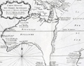 | Details | Prevost, Antoine-Francois | 1753 |
| Histoire générale des voyages tome onzième v 11 |
|
Prevost, Antoine-Francois |
|
| 1753 |
| LOC:2001 |
| $1,750.00 | Prevost--Antoine-Francois | Histoire-générale-des-voyages-tome-onzième-v-11 | Volume 11 of Prevost's history of voyages to the south sea. Contains accounts of the explorations of Narborough, Wood, Anson, Dampier, Carieri and others. Plates of unusual animals and six plates of botannicals with copper-engraved maps as below. <b>Includes two very desirable, foundational maps of Australia</b> with the continent shown attached to Tasmania:
<div class="indenttextblocksingle">
<ul style="list-style-type: circle;">
<li>"Carte reduite des Terres Australes pour servir …" by Nicolas Bellin. 1753. (11" x 8"). Very good.</li>
<li>"Carte reduite de la Mer du Sud pour servir ..." by Nicolas Bellin. 1753. (14" x 8"). Good. </li>
</ul>
</div>
French text. Volume 11- tome onzième. Second Partie. "Histoire Generale des voyages, ou nouvelle collection de toutes les relations de voyages par mer et par Terre, qui ont ete publiees jusqu'a present dans les differentes langues de toutes les nations connue …". Published by Didot from Paris in 1753.
<br></br>
Contents include but are not limited to these plates:
<div class="indenttextblocksingle">
<ul style="list-style-type: circle;">
<li>Carte reduite de la partie la plus meridionale de l'Amerique No. 1</li>
<li>Carte reduite du Detroit de Magellan No. 2</li>
<li>Carte de l'Isle de Caienne No. 3</li>
<li>La Ville de Cayenne No. 4</li>
<li>Carte du Detroit de le Maire No. 5</li>
<li>Carte particuliere de l'Isle de Juan Fernandez No. 6</li>
<li>Coste du Nord Est de l'Isle de Juan Fernandez No. 7</li>
<li><b>Carte reduite des Terres Australes No. 8</b></li>
<li><b>Carte reduite de la Mer du Sud No. 9</b></li>
<li><b>Representation du cours ordinaires des vents … Mer du Sud</b> No. 10</li>
<li>Vue de la Place de Juan Fernandez No. 13</li>
<li>Batiment leger des Isles de Larrons No. 14</li>
</ul>
</div> |
| 1128 | 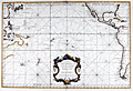 | Details | Depot de la Marine | 1756 |
| Antique French Sea Chart of the Pacific Ocean with Australia |
|
Depot de la Marine |
|
| 1756 |
| LOC:62 |
| $2,200.00 | Depot-de-la-Marine | Antique-French-Sea-Chart-of-the-Pacific-Ocean-with-Australia | Antique sea chart of the Pacific Ocean with a very decorative rococo cartouche. This old French nautical chart contains incomplete representations of Australia and New Zealand coastal regions, reflecting the lack of knowledge that still existed at that time. 2nd. Ed. By J.N. Bellin. A later edition of this chart includes the Depot de la Marine engraved stamp at bottom left.
<br></br>
Coverage spans the Pacific from east Asia to the east coast of the United States. The chart will display beautifully when framed. |
| 870 | 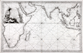 | Details | Bellin, Jacques Nicolas | 1757 |
| French sea chart of the Indian Ocean with Australia |
|
Bellin, Jacques Nicolas |
|
| 1757 |
| LOC:0 |
| $0.00 | Bellin--Jacques-Nicolas | French-sea-chart-of-the-Indian-Ocean-with-Australia | SOLD
<br></br>
Attractive antique French sea chart of the Indian Ocean with Australia, the southern half of Africa, Madagascar, Reunion Island ( "Île Bourbon" ), the Red Sea, Saudi Arabia and the Persian Gulf, India, Malaysia, Indonesia, the Philippines, and Taiwan. Key cities on this 1757 nautical chart include Macao, Manilla, Jakarta ( "Batavia" ), Mumbai ( "Bombay" ), Mecca ( "la Meque" ), and Cape Town.
<br></br>
Bellin's depiction of the west coast of Australia ("Terres Australes" or "Nouvelle Hollande") is worth a few words. At the time the chart was produced in the mid-eighteenth century much the Australian coastline was poorly charted. The coast of Australia was first sighted and charted by Willem Janszoon aboard the Dutch vessel Duyfken in 1606. Later Dutch, French and English explorers including William Dampier added to the outline of west Australia, but there was still significant uncertainty about coastal detail and location. Bellin conveys this ambiguity by the use of a very light and often broken outline for most of the south and west coastline. Where Bellin felt more certainty, as on the north coast he used a bold engraved outline with hachured coastal relief to convey a sense of certitude. Bellin provides three notes referring to his sources. Translated from French they are roughly:
<div class="indenttextblock">
<ul>
<li>Terre de Concorde discovered in 1628., </li>
<li>Bay of Sea-Dogs ( "Chiens Marines" ) [or Shark Bay], viewed by Dampier in 1699. , and</li>
<li>Coast viewed by Mr. Duquesne in 1687.</li>
</ul></div>
Attractive title cartouche with palm trees and African animals including a crocodile, elephant, and lion. As stated in the title the chart was produced for use by the French Navy. Unlike many other French charts there is no price noted, substantiating the premise that this copy was not intended for public consumption. |
| 1270 | 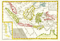 | Details | Bonne, Rigobert | 1780 |
| Attractive antique map of the East Indies and north Australia |
|
Bonne, Rigobert |
|
| 1780 |
| LOC:0 |
| $0.00 | Bonne--Rigobert | Attractive-antique-map-of-the-East-Indies-and-north-Australia | SALE PENDING <br></br>
Attractive antique copperplate-engraved map of the islands of Java, Sumatra, Celebes, Malaca, Borneo, New Guinea (shown only partially due to incomplete exploration in the late 18th century) as well as the tip of Australia's northern coast(s) with each side of the Cape York Peninsula or "Terre du Sud" named: Terre de Diemen (west) and Terre d'Arnheim (east).
<br></br>
Arrow notations depict the directions of the winds during the various months of the year. Includes an inset map of the Moluccan Islands - the Spice Islands.
<br></br>
From "Atlas de toutes les parties connues du Globe Terrestre, dressé pour l’histoire philosophique et politique des établissemens et du commerce des européens dans les deux Indes. "
<br></br>
Rigobert Bonne (1727-1794) was the successor to Jacques Nicolas Bellin as Royal Cartographer to France in the office of the Hydrographer at the Depôt de la Marine. Bonne first came to prominence when he published a number of charts in the Atlas Maritime in 1762. He is better known for later publications, including the Atlas Encyclopedique, which he collaborated on with Nicholas Desmarest, as well as the maps he produced for Raynal's Atlas de Toutes Les Parties Connues du Globe Terrestre, which was published in 1780. |
| 1331 | 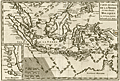 | Details | Bonne, Rigobert | 1780 |
| Fine antique map of the Moluccas and North Australia |
|
Bonne, Rigobert |
|
| 1780 |
| LOC:6 |
| $240.00 | Bonne--Rigobert | Fine-antique-map-of-the-Moluccas-and-North-Australia | Attractive antique uncolored copperplate-engraved map of the islands of Java, Sumatra, Celebes, Malaca, Borneo, New Guinea (shown only partially due to incomplete exploration in the late 18th century) as well as the tip of Australia's northern coast(s) with each side of the Cape York Peninsula or "Terre du Sud" named: Terre de Diemen (west) and Terre d'Arnheim (east).
<br></br>
Arrow notations depict the directions of the winds during the various months of the year. Includes an inset map of the Moluccan Islands - the Spice Islands.
<br></br>
From "Atlas de toutes les parties connues du Globe Terrestre, dressé pour l’histoire philosophique et politique des établissemens et du commerce des européens dans les deux Indes. "
<br></br>
Rigobert Bonne (1727-1794) was the successor to Jacques Nicolas Bellin as Royal Cartographer to France in the office of the Hydrographer at the Depôt de la Marine. Bonne first came to prominence when he published a number of charts in the Atlas Maritime in 1762. He is better known for later publications, including the Atlas Encyclopedique, which he collaborated on with Nicholas Desmarest, as well as the maps he produced for Raynal's Atlas de Toutes Les Parties Connues du Globe Terrestre, which was published in 1780. |
| 1260 | 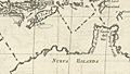 | Details | de Luque, Eduardo Malo | 1784 |
| Scarce Spanish Map of Australasia with Australia |
|
de Luque, Eduardo Malo |
|
| 1784 |
| LOC:0 |
| $0.00 | de-Luque--Eduardo-Malo | Scarce-Spanish-Map-of-Australasia-with-Australia | SOLD
<br></br>
Attractive and scarce antique Spanish map of Australasia with the Moluccas Islands, Philippines, Borneo, Java, Indonesia, New Guinea, and <b>Northern Australia</b> (Nueva Holanda). With an inset map of the "Verdaderas Malucas". Arrows show the prevailing winds. Covers portions of the Java Sea, Banda Sea, Timor Sea, and Celebes Sea and other bodies of water.
<br></br>
By Eduardo Malo de Luque and published 1784 from Madrid in "Historia política de los establecimientos ultramarinos de las naciones europeas". |
| 2501 |  | Details | Arrowsmith, Aaron | 1804 |
| New Holland or Australia by Aaron Arrowsmith |
|
Arrowsmith, Aaron |
|
| 1804 |
| LOC:6 |
| $0.00 | Arrowsmith--Aaron | New-Holland-or-Australia-by-Aaron-Arrowsmith | SOLD
<br></br>
Antique map of Australia from Arrowsmith's large chart of the Pacific Ocean, published here in smaller format. (Published by John Conrad & Co., Philadelphia. 1804).
<br></br>
The odd shape of the Australian continent reflects the poor knowledge of that continent in 1804. Use of dark coloration for the sea makes this plate easily distinguishable from other maps of the era. Contains interesting comments about the geography and documents dates of exploration for the Australian coast. Edel's Land. 1619; C.F. de Wits Landt Discovered in 1628 Black Inhabitants;
<br></br>
This unusual antique map was published in A new and elegant general atlas, comprising all the new discoveries, to the present time. Containing sixty-three maps, drawn by Arrowsmith and Lewis. Published by John Conrad & Co. [and others]. Philadelphia . 1804.
(Source: davidrumsey.com). |
| 1131 | 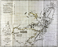 | Details | Arrrowsmith, John | 1832 |
| Antique map of southeast Australia with discoveries |
|
Arrrowsmith, John |
|
| 1832 |
| LOC:9 |
| $560.00 | Arrrowsmith--John | Antique-map-of-southeast-Australia-with-discoveries | SOLD
<br></br>
Scarce antique map by John Arrowsmith (1790-1873) is an early record of Australian history. The old map documented recent discoveries (as of 1832) in the interior of the southeastern portion of the continent of Australia. Coverage includes the Australian coastline from Brisbane to Adelaide (not named as it was not founded until 1836, 4 years after publication of this map).
<br></br>
Contains light outline color denoting tracks of exploration in the region between 1817 and 1829, and the miles explored by each. The explorers include: General Oxley, Lieutenant Currie, Mr. Hume, Mr. Allan Cunningham, and Captain Stuart.
<br></br>
Portions of the coast are denoted with dashed lines indicating that even by 1832 there were parts of the coast that were still poorly explored. Numerous notes about the character of the geography geology, and fauna of the region. For example Lake Alexandrina is described:
<div class="indenttextblock">
"The Lake is 50 miles long and 40 broad very shallow in some places, has several fine Bays, its water brackish it communications with Encounter Bay by a passage impracticable even for the smallest boats...The rise of the Tide does not exceed 8 inches."
</div>
<br />
Published in 1832 from London in Vol. 2 of the Journal of the Royal Geographical Society.
<br></br>
John Arrowsmith was a cartographer to both the Royal Geographical Society and the Parliamentary Reports. Those roles gave Arrowsmith access to information on the latest discoveries and he created numerous maps of Australia and other areas, revising the maps with results of later information. Published by John Murray, Albemarle Street. London. |
| 1112 | 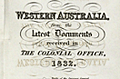 | Details | Royal Geographical Society of London | 1832 |
| Western Australia from the latest documents received in the Colonial Office, 1832 |
|
Royal Geographical Society of London |
|
| 1832 |
| LOC:0 |
| $0.00 | Royal-Geographical-Society-of-London | Western-Australia-from-the-latest-documents-received-in-the-Colonial-Office--1832 | SOLD<br></br>
This antique map of Western Australia is the earliest available map to show the new state of Western Australia, renamed from the "Swan River Colony" in 1832. The map shows the Swan River estuary, the topography of the southwestern coastline, and features the exploration tracks of the Surveyor General (J.S. Roe), R. Dale, Capt. Bannister, Lieut. Preston, Capt. A. Collie and Capt. Currie, members of the Swan River colony whose efforts assisted in the founding of the towns of Perth and Fremantle.
<br></br>
Key features include the port city of Albany on King George's sound, founded in 1826; Rottnest Island and Garden Island off the west coast near Freemantle; Port Vasse, Cape Naturaliste, and Port Leschenault all near Geographe Bay named by French explorer Nicolas Baudin in 1801.
<br></br>
The first European settlement of Western Australia occurred following the landing by Major Edmund Lockyer in 1826. In January 1827 Lockyer took possession of the western third of the continent for the British Crown. This was followed by the establishment of the Swan River Colony in 1829, including the site of the present-day capital, Perth. In 1832 the Swan River Colony was officially renamed "Western Australia".
<br></br>
The map accompanied an article "Recent Information from Australia" by T.L. Mitchell and A.C. [A. Cunningham] V2 of the Journal of the Royal Geographical Society by John Murray, Albemarle St., September. 1832. |
| 4753 |  | Details | Depot de la Marine | 1837 |
| Early French-surveyed Chart of Sydney, Australia |
|
Depot de la Marine |
|
| 1837 |
| LOC:0 |
| $0.00 | Depot-de-la-Marine | Early-French-surveyed-Chart-of-Sydney--Australia | SOLD<br></br>
Fine first edition French Chart of the Harbor at <b>Sydney, Australia</b> (Port Jackson) based on surveys carried out by French Captain Bougainville . Baron Hyacinthe de Bougainville was the son of the famous French Pacific navigator Louis-Antoine de Bougainville. An officer of the French navy, in 1825 he commanded an expedition that took the ships Thetis and Esperance to Macau, Manila and New South Wales.
<br></br>
This French survey, by Baron de Bougainville, was the fourth state-sponsored delineation of the topography and hydrography of Port Jackson. Oval seller's stamp "Cercle Maritime. Brest".
<br></br>
The first depiction was after a compass survey conducted over just nine days by John Hunter and William Bradley, published by George Raper in 1791. During an expedition to the south-west coast of Australia, de Freycinet (1802) updated Hunter's chart with additional soundings from his own survey of Port Jackson. John Septimus Roe led the third survey in 1822 followed with this chart published in 1828 by French explorer Hyacinthe de Bougainville.
<br></br>
An original, treasured gift for anyone with interests in boating or sailing near Sydney. At top, a fine, engraved vue or "View of the Entrance to the Harbor at Port Jackson." Dated 1828 but 1837 with its publication as Plate 52 from:
<div class="indenttextblock">Journal de la navigation autour du globe de la fregate la Thetis et de la corvette l'Esperance pendant les annees 1824, 1825 et 1826 /Publie par ... M. le Baron de Bougainville. Paris : Arthus Bertrand, 1837. Grave par Ambroise Tardieu d'apres les dessins de M.E.B. de la Touanne, Lieutenant de Vaisseau. Ecrit par Besancon. Prix un franc.
</div></BR>
(Fr. Rare et grande carte marine de Port Jackson (Sydney, Australie) publiée par le Depot de la Marine de France.) Port Jackson, aussi appele Sydney Harbour, est le port naturel de Sydney en Australie.
<br></br>
Top left-hand corner: Voyage de la Thetis et de l'Esperance. |
| 1122 |  | Details | Arrrowsmith, John | 1838 |
| Australia according to the proposed divisions |
|
Arrrowsmith, John |
|
| 1838 |
| LOC:0 |
| $0.00 | Arrrowsmith--John | Australia-according-to-the-proposed-divisions | SOLD <br></br>
This small antique map by John Arrowsmith (1790-1873) is an early record of Australian history as it documents a proposed naming convention and geographical boundaries for states in the continent of Australia.
<br></br>
Published for the Journal of the Royal Geographical Society to accompany an article "Considerations on the Political Geography and Geographical Nomenclature of Australia".
<br></br>
These proposed states were geometric divisions of the continent, and did not take into account soil fertility, aridity or population. This meant that central and western Australia were divided into several states, despite their low populations both then and now.
<br></br>
<h3>Proposed Divisions of Australia</h3>
<br />
<div class="indenttextblock" style="list-style-type: circle;">
<ul>
<li>Dampiera</li>
<li>Victoria</li>
<li>Tasmania (not to be confused with the modern Tasmania).</li>
<li>Nuytsland</li>
<li>Carpentaria</li>
<li>Flindersland</li>
<li>Torresia</li>
<li>Cooksland</li>
<li>Guelphia</li>
<li>Vam Dieman's Land (modern-day Tasmania)</li>
</ul>
</div>
John Arrowsmith was a cartographer to both the Royal Geographical Society and the Parliamentary Reports. Those roles gave Arrowsmith access to information on the latest discoveries and he created numerous maps of Australia and other areas, revising the maps with results of later information. Published by John Murray, Albemarle Street. London. |
| 57 |  | Details | Vincedon-Dumoulin | 1858 |
| Carte de la Cote Orientale de la Nouvelle Hollande |
|
Vincedon-Dumoulin |
|
| 1858 |
| LOC:59 |
| $1,100.00 | Vincedon-Dumoulin | Carte-de-la-Cote-Orientale-de-la-Nouvelle-Hollande | Fine engraved lines define geographic boundaries in this copperplate engraved antique French navigational chart of Eastern Australia, the Great Barrier Reef, the Coral Sea, New Caledonia, and North New Zealand. Based on the voyages of French explorer Dumont D'urville in the 1820's and 1830's . <BR> </BR>
Contains the circular anchor stamp of the Depot General de la Marine. With a black over-stamp for Cartes de la Marine Impériale. Debrie Libraire au Harve, Seul Depositaire. Price: two Francs. Plate 1. Edition of 1858. |
| 59 | 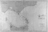 | Details | Depot de la Marine | 1864 |
| Detroit du Bass (Australie) |
|
Depot de la Marine |
|
| 1864 |
| LOC:59 |
| $1,400.00 | Depot-de-la-Marine | Detroit-du-Bass-(Australie) | Interesting antique nautical chart of South Australia, the Bass Straight and upper coast of Tasmania published by the Depot des Cartes et Plans de la Marine ( France ). Numerous lighthouses marked as red dots with yellow highlights and red circles indicating scope of lighthouse visibility. Includes Port Phillip and the city of Melbourne. Right center includes inset profile views. <BR> </BR>
With a black over-stamp for Cartes de la Marine Impériale. Debrie Libraire au Harve, Seul Depositaire. Price: Deux Francs. |
| 53 | 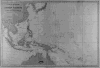 | Details | Vincedon-Dumoulin | 1865 |
| Carte Generale de l'Ocean Pacifique |
|
Vincedon-Dumoulin |
|
| 1865 |
| LOC:0 |
| $0.00 | Vincedon-Dumoulin | Carte-Generale-de-l-Ocean-Pacifique | This chart is SOLD. <BR> </BR>
French navigational chart of Japan, Southern China and the Pacific Islands including New Guinea, Solomon Islands, Borneo, Samoa, Tonga, and many more. Based on the voyages of French explorer Dumont D'Urville in the 1820's and 1830's . With a black over-stamp for Cartes de la Marine Impériale. Debrie Libraire au Harve, Seul Depositaire. Price: two Francs. Plate 1. Edition of 1865. |
| 1322 | 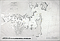 | Details | Depot de la Marine | 1869 |
| Rare Antique Nautical Chart of Port Jackson, Australia (Sydney) |
|
Depot de la Marine |
|
| 1869 |
| LOC:0 |
| $0.00 | Depot-de-la-Marine | Rare-Antique-Nautical-Chart-of-Port-Jackson--Australia-(Sydney) | SOLD <br></br>Rare and early large Gold-Rush era nautical chart of Port Jackson (Sydney, Australia) published by France's Depot de la Marine in 1861 (last corrections in 1869) based on the 1857 British Admiralty survey made under the command of Captain Denham. Large early nautical charts of Sydney / Port Jackson are very scarce. No record of a sale of this large chart (British or French) is found in the Antique Map Price Record. Includes a elevation view of Port Jackson as seen from offshore.
<br></br>
In his analysis of the accuracy of early charts of Sydney Harbor, Mulhearn noted:
<div class="indenttextblock">"The 1857 British Admiralty survey was carried out by Hutchison under the direction of a Captain Henry Mangles Denham F.R.S. who had been tasked with surveying parts of the south-west Pacific in HMS Herald. The chart of this survey, engraved in 1859, had the high soundings density one would expect with a modern hydrographic survey and it clearly marks a significant departure from earlier mapping efforts of Sydney Harbour. The area covered was from 1.5 miles (2.4 km) seawards of the harbour entrance west to Five Dock Bay. However sounding densities were relatively sparse west of Cockatoo Island, where a new dry dock, Fitzroy Dry Dock, was opened in late 1857. The survey and initial chart production took approximately two months." <a href="http://www.e-perimetron.org/Vol_9_2/Mulhearn.pdf " target="_blank">Online.</a></div>
<br></br>
The total population of Sydney and its suburbs in 1861 is estimated at 95,000 persons. |
| 209 |  | Details | Sawtell, Alfred E. | 1874 |
| Sawtells Nautical Almanac |
|
Sawtell, Alfred E. |
|
| 1874 |
| LOC:0 |
| $0.00 | Sawtell--Alfred-E- | Sawtells-Nautical-Almanac | SOLD<br><br>
Small extremely scarce antique 64 page nautical almanac published by Alfred E. Sawtell of Port Adelaide, Australia in 1874 less than 40 years after colonists founded the city. Probably a relatively early printing as an Adelaide newspaper advertisement from 1901 lists the Almanac still for sale, although now updated with colored plates and enlarged at 324 pages.<BR> </BR>
Very interesting early Australian nautical reference would be a good fit for collectors of 19th century Australian sea charts or nautical books. Along with an ephemeris and tide tables the contents include information on courses and distances, sailing directions, pilotage dues, a 7 page list of Australian vessels and their tonnage, and ships regulations for bathing, sanitation and gunpowder. <BR> </BR>
Back cover advertisement describes A.E. Sawtell as: "Chronometer, Watchmaker, Nautical Optician, Chart and Nautical Bookseller". An enclosed stock list includes nautical books, charts, chronometers and "transparent dipping needle and plain compass cards all sizes". 32 page advertising supplement contains ads for many nautical services and goods including : "J. Hill and Co. Omnibus Proprietors", "J. Lavin Steam Biscuit Manufactory" and the "80 HORESPOWER steam tugs Eleanor and Sophia". Feel the power! |
| 1464 | 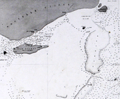 | Details | Depot de la Marine | 1874 |
| Detroit de Torres. Second sheet. |
|
Depot de la Marine |
|
| 1874 |
| LOC:59 |
| $200.00 | Depot-de-la-Marine | Detroit-de-Torres---Second-sheet- | Fine antique small-scale nautical chart (Sheet 2 of 3) of northern Torres Strait, the body of water separating the continent of Australia (Nouvelle Hollande) from New Guinea. Last corrections in 1874. One of 4 charts of the Torres Strait area produced by the Depot de la Marine, this being the second detail sheet encompassing the north end of the strait near New Guinea. |
| 1465 | 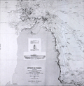 | Details | Depot de la Marine | 1875 |
| Detroit de Torres. Third sheet with Raine Island |
|
Depot de la Marine |
|
| 1875 |
| LOC:59 |
| $600.00 | Depot-de-la-Marine | Detroit-de-Torres---Third-sheet-with-Raine-Island | Fine antique small-scale nautical chart (Sheet 3 of 3) of southern Torres Strait, the body of water separating the continent of Australia (Nouvelle Hollande) from New Guinea. Last corrections in 1874. One of 4 charts of the Torres Strait area produced by the Depot de la Marine, this being the third detail sheet encompassing the south end of the strait and the tip of the Cape York Peninsula in north Australia.
<br></br>
<b>Inset drawings of Raine Island and the tower on Raine Island</b>, on the outer edges of the Great Barrier Reef, about 120 km east-northeast of Cape Grenville, Cape York Peninsula. Raine Island, a small vegetated coral cay, is the site of the oldest European structure in tropical Australia, a stone beacon built in 1844. An important environmental icon, Raine island got its name from Captain Thomas Raine (1793-1860), the English mariner who discovered it. |
| 1466 | 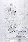 | Details | Depot de la Marine | 1875 |
| Detroit de Torres First sheet with York Island |
|
Depot de la Marine |
|
| 1875 |
| LOC:59 |
| $600.00 | Depot-de-la-Marine | Detroit-de-Torres-First-sheet-with-York-Island | Fine antique small-scale nautical chart (Sheet 1 of 3) of southern Torres Strait, the body of water separating the continent of Australia (Nouvelle Hollande) from New Guinea. First published in 1860 with last corrections made in 1875.
<br></br>
One of 4 charts of the Torres Strait area produced by the Depot de la Marine, this being the first detail sheet encompassing the Cape York Peninsula, York Island "Ile du Prince de Galles", Eborac Island, and numerous other cays and islands in the Torres Strait Archipelago. |
| 4976 | 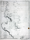 | Details | British Admiralty Hydrographical Office | 1875 |
| Admiralty chart of Australia Magnetic Island to Double Point Barrier Reefs |
|
British Admiralty Hydrographical Office |
|
| 1875 |
| LOC:59 |
| $1,300.00 | British-Admiralty-Hydrographical-Office | Admiralty-chart-of-Australia-Magnetic-Island-to-Double-Point-Barrier-Reefs | Antique British Admiralty navigation chart of the East Coast of Australia, sheet 15 in a series. Coverage includes Moresby River, Mourliyan Harbor, the King Reefs, Bay Hill, Dunk Island, Kennedy Bay, Rockingham Bay, Goold Island, Port Hinchinbrook, Bishops Peak, Halifax Bay.
<br></br>
Map clearly features several sources of fresh water, low mangrove swamps, sugar plantations, and much of the inner Australian Barrier Reef. Includes a large poorly mapped region of the east Australian coast noted as: "Low wooded coast and apparently much occupied by lagoons".
<br></br>
Colophon: Published according to an Act of Parliament at the Hydrographic Office of the Admiralty March 20th, 1855. Sold by J.D. Potter. |
| 1330 | 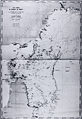 | Details | Depot de la Marine | 1875 |
| Antique Chart of Cape York Peninsula, Australia and Torres Strait |
|
Depot de la Marine |
|
| 1875 |
| LOC:59 |
| $800.00 | Depot-de-la-Marine | Antique-Chart-of-Cape-York-Peninsula--Australia-and-Torres-Strait | Fine antique small-scale nautical chart of the Torres Strait, the body of water and passage separating the continent of Australia (Nouvelle Hollande) from New Guinea. Last corrections in 1875. Prominently shows the Cape York Peninsula, the northern-most portion of the Australian state of Queensland, surrounded by the Sea of Carpenteria to the west and the Coral Sea to the east. New Guinea lies to the north. (One of 4 charts of the Torres Strait area, this being the general chart of the entire area).
<br></br>
Published by the French Depot des Cartes and Plans de la Marine in 1860, this edition with corrections to 1875. Number 1861. |
| 1468 | 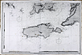 | Details | British Admiralty Hydrographical Office | 1875 |
| Gulfs of St. Vincent and Spencer Southern Sheet 2 |
|
British Admiralty Hydrographical Office |
|
| 1875 |
| LOC:59 |
| $1,300.00 | British-Admiralty-Hydrographical-Office | Gulfs-of-St--Vincent-and-Spencer-Southern-Sheet-2 | A special chart in excellent condition for the collector of Australian maps. This antique British Admiralty sea chart contains both the town of Adelaide, Australia AND also bears the blue sellers over-stamp of A.E. Sawtell a chart-seller from Port Adelaide, Australia from at least 1874 to 1901 or later (See <a href="https://www.rarecharts.com/ShowDetail/Creator/Sawtell--Alfred-E-/Title/Sawtells-Nautical-Almanac/209" target="_blank">Sawtell's 1874 nautical almanac</a> from our archives.).
<br></br>
The southern sheet of a large 2-sheet sea chart, unjoined. Last correction in 1875. Covers the southern portion of St. Vincent Gulf and Spencer Gulf with Investigator Strait, the MacDonnell Peninsula, Kangaroo island, Wedge Island, Thistle Island, Encounter Bay, Aldinga Bay, and Holdfast Bay . Shows the nascent town of Adelaide, Australia with several neighboring villages including: Plympton, Kensington, Beaumont, Norwood, and Glenelg.
<br></br>
Three inset coastal profile views taken from various directions including one view that is labeled: "Outline of the Land on the East side of St. Vincent Gulf as seen from a vessel's deck when running up Troubridge Lighthouse bearing N.W. by W 1/2 W. 9 1/2 miles."
<br></br>
Publisher's attribution reads: "Published at the Admiralty 17 Aug. 1874 under the Superintendance of Captain F.J. Evans R.N., C.B, F.R.S. Hydrographer ." Number 2389b.
<br></br>
Alfred E. Sawtell, was a seller of nautical charts and instruments from Port Adelaide Australia. Sawtell published a Nautical Almanac in 1874 containing an ephemeris, tide tables, sailing directions for Australian ports, pilotage dues, a 7 page list of Australian vessels and their tonnage; and ships regulations for bathing, sanitation and gunpowder. In that almanac the back cover advertisement describes A.E. Sawtell as: "Chronometer, Watchmaker, Nautical Optician, Chart and Nautical Bookseller". |
| 1469 | 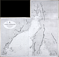 | Details | British Admiralty Hydrographical Office | 1875 |
| Gulfs of St. Vincent and Spencer Northern Sheet 1 |
|
British Admiralty Hydrographical Office |
|
| 1875 |
| LOC:59 |
| $1,350.00 | British-Admiralty-Hydrographical-Office | Gulfs-of-St--Vincent-and-Spencer-Northern-Sheet-1 | A very special chart in excellent condition for the collector of Australian maps. The northern sheet of a large 2-sheet sea chart, covering Port Adelaide and sold by a nautical chart-seller from Port Adelaide.
<br></br>
This antique British Admiralty sea chart contains both the town of Port Adelaide, Australia AND also bears the blue sellers over-stamp of A.E. Sawtell a chart-seller from Port Adelaide, Australia from at least 1874 to 1901 or later. (See <a href="https://www.rarecharts.com/ShowDetail/Creator/Sawtell--Alfred-E-/Title/Sawtells-Nautical-Almanac/209" target="_blank">Sawtell's 1874 nautical almanac</a> from our archives.) Chart is In fine condition. North sheet of a large 2-sheet sea chart, unjoined but with a wing-sheet, an extension to the chart as issued covering northern-most Spencer Gulf miles past Port Augusta, Australia.
<br></br>
Covers the northern portion of St. Vincent Gulf and Spencer Gulf.
<br></br>Bottom sheet (2) publisher's attribution reads: "Published at the Admiralty 17 Aug. 1874 under the Superintendance of Captain F.J. Evans R.N., C.B, F.R.S. Hydrographer ." Number 2389a.
<br></br>
Bottom sheet (2) seller's information: "Sold by J.D. Potter Agent for sale of the Admiralty, 31 Poultry and 11 King Street, Tower Hill."
<br></br>
Alfred E. Sawtell, was a seller of nautical charts and instruments from Port Adelaide Australia. Sawtell published a Nautical Almanac in 1874 containing an ephemeris, tide tables, sailing directions for Australian ports, pilotage dues, a 7 page list of Australian vessels and their tonnage; and ships regulations for bathing, sanitation and gunpowder. In that almanac the back cover advertisement describes A.E. Sawtell as: "Chronometer, Watchmaker, Nautical Optician, Chart and Nautical Bookseller". An enclosed stock list included nautical books, charts, chronometers and "transparent dipping needle and plain compass cards all sizes". |
| 950 | 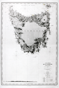 | Details | Depot de la Marine | 1876 |
| Antique Nautical Chart of Tasmania, Australia |
|
Depot de la Marine |
|
| 1876 |
| LOC:59 |
| $3,275.00 | Depot-de-la-Marine | Antique-Nautical-Chart-of-Tasmania--Australia | A bold, large, antique French hydrographic chart of the island of <b>Tasmania</b>, a part of the Commonwealth of Australia, after an English chart by F.J. Evans, master of the British Royal Navy (1860). Beautifully engraved, this old nautical chart on laid paper was first published by France's Depot de la Marine in 1867 and last updated with corrections in 1876. Coverage to the north includes portions of the Bass Strait and Banks Strait; Cape Barren Island and Clarke Island; and the Hunter Islands. Key features noted in Tasmania are largely within a few hundred miles of the coast; the interior is devoid of detail. Includes <b>Port Dalrymple</b>, George Town, Port Maquarie, Port Davey, Hobart ("Hobarttown"), the Derwent River and Fleurieu Bay.
<br></br>
Near bottom of the chart is found a elevation view of the southern approaches to the island extending from Maatsuyker Island to Cape Tasman. Elevation detail is shown by meticulous hachuring and shading and includes numeous peaks on that mountainous island. Mount Wellington, Cradle Mountain, Frenchman's Cap, Mount Victoria, and Eldon Peak are a few of the numerous peaks noted even though many of the highest peaks on the island had yet to be discovered as late as the mid 19th century.
<br></br>
Tasmania was first discovered in 1642 by an expedition led by Dutch explorer Abel Tasman aboard ships of the Dutch East India Company. During the first part of the 19th century the island served as the main penal colony for Australia and as many as 75,000 convicts were transported there. The island was originally known as <b>Van Diemen's Land</b>, a practice that continued until 1856 when it was renamed Tasmania . Number 2536.
<br></br> |
| 6417 | 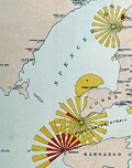 | Details | Marine Board of South Australia | 1885 |
| Lighthouse Map of the Province of South Australia Rare Chart |
|
Marine Board of South Australia |
|
| 1885 |
| LOC: |
| $2,195.00 | Marine-Board-of-South-Australia | Lighthouse-Map-of-the-Province-of-South-Australia-Rare-Chart | A fine, unrecorded edition of the Lighthouse Map of the Province of South Australia January 1, 1885 published by the Marine Board of South Australia, Thomas N. Stevens, Secretary. Inset maps showing light beacons for Port Adelaide River and Port Pirie River. "The Marine Board was responsible for shipping safety, buoys, lighthouses and explosives amongst other functions." [1]
<br><br>
Large format charts of lighthouses displaying graphically the light color, period, and distance visible are very rare. See [2], [3]. For Australia this is the only copy recorded of this map for the 1885 edition. Only three other editions with one copy each (1881, 1883, and 1885) are held in Australian institutions. No copy of the 1885 edition is found anywhere online nor are any sales recorded in AMPR for any copy of this Australian Lighthouse Map.
<br><br>
P.P. No. 43. Lithographed by E. Spiller, Government Printer, Adelaide.
<br><br>
Inset index tables: (1) Reference to Lights with the lighthouse name, color, distance visible, period and other key data for each lighthouse. (2) List of Government Wharves and Jetties Showing Length and Depth of Water at Low Water.
<br><br>
Coverage of this Australian lighthouse chart stretches from Waterloo Bay at the west to Cape Northumberland at the south east. Includes the waters of Spencer Gulf, Separator Strait, Kangaroo Island, and the Gulf of St. Vincent with Port Adelaide.
<br><br>
[1] Encyclopedia of Australian Science. Online: https://www.eoas.info/biogs/P006561b.htm. <br>
[2] BRITISH LIGHTHOUSE CHART OF GENERAL COAST LIGHTS. Compiled from authentic sources by Woolfield H. F. Hardinge. London: J. D. Potter Admiralty Chart Agent, 1874.[3] <br>
[3] A Chart exhibiting the Light Houses and Light Vessels of the Coasts of Great Britain and Ireland and also those on the N.W. coasts of Europe between Ushant and Bergen. Alexander G. Findlay. London. Corporation of Trinity House. Published by R. H. Laurie. 1863. |
| 6353 |  | Details | Coyle, J. E. F. | 1895 |
| Blueprint Sydney Northbridge Suspension Long Gully Bridge |
|
Coyle, J. E. F. |
|
| 1895 |
| LOC:300 |
| $1,500.00 | Coyle--J--E--F- | Blueprint-Sydney-Northbridge-Suspension-Long-Gully-Bridge | Beautiful, original late 19th century cyanotype (blueprint) profile view of the "North Sydney Bridge" NSW, then a suspension bridge, (also known as Northbridge or Long Gully Bridge). Original 48" rolled old blueprint paper with slight signs of wear consistent with date of late 19th century but fresh and bright from a protected environment. The rigid symmetry of the suspension bridge contrasts with the sketch-like character of the title and gully profile. Scale 20' = 1".
<br></br>
The Suspension Bridge in Northbridge, NSW was built as a steel suspension bridge with sandstone turreted towers by a private syndicate to promote residential development. The bridge opened to traffic in in January, 1892. With a suspension span of about 500 feet, it was considered one of the engineering wonders of Sydney and became a great tourist attraction. In 1939 the bridge was rebuilt as a reinforced concrete two rib arch bridge, with the original towers intact. (1)
<br></br>
Manuscript address on the verso "F. L. Keir Esq. Chief Engineer's. Railway Department. Brisbane. Queensland." Keir was an engineer with the railways department (2).<br /><br />
Sources:<br /> |
| 6407 | 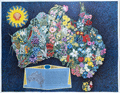 | Details | Santos, George | 1959 |
| Rare pictorial map of Australia with local wildflowers for Shell Oil Company |
|
Santos, George |
|
| 1959 |
| LOC:89 |
| $0.00 | Santos--George | Rare-pictorial-map-of-Australia-with-local-wildflowers-for-Shell-Oil-Company | OH HOLD
<br><br>
An original and beautiful 1959 lithographed pictorial map of Australia decorated profusely with wildflowers. Guaranteed original. Scarce on today's market.
<br><br>
Artwork by George Santos for the Shell Oil Company of Australia. Shell Oil Company logo at upper left.
<br><br>
Overall dimensions: 17.5 in. x 22.25 or 45 cm. x 57 cm.
<br><br>
Legend contains an inset key map and a list that denotes the names of 87 wildflowers related numerically to positions on the key map.
<br><br>
Very rare. Only two institutional holdings are cataloged in WorldCat, both within Australia.
<br><br>
At extreme bottom right the imprint of McCarron Bird, Melbourne, Australia. |
| 6410 | 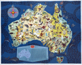 | Details | Santos, George | 1959 |
| Rare pictorial map of Australia with local fauna produced for Shell Oil Company |
|
Santos, George |
|
| 1959 |
| LOC:89 |
| $1,200.00 | Santos--George | Rare-pictorial-map-of-Australia-with-local-fauna-produced-for-Shell-Oil-Company | A very beautiful original 1959 lithographed pictorial map of Australia decorated profusely with drawings of Australian animals. Guaranteed original. Scarce on today's market.
<br><br>
Artwork by George Santos for the Shell Oil Company of Australia. Shell Oil Company logo at upper left.
<br><br>
Overall dimensions: 17.5 in. x 22.25 or 45 cm. x 57 cm.
<br><br>
Legend contains an inset key map and a list that denotes the names of the animals related numerically to positions on the key map.
<br><br>
Very rare. Only two institutional holdings are cataloged in WorldCat, both within Australia. |
| 6486 | 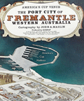 | Details | Maslin, John A. | 1985 |
| America's Cup pictorial bird-eye view of Freemantle, Western Australia |
|
Maslin, John A. |
|
| 1985 |
| LOC:1404 |
| $350.00 | Maslin--John-A- | America-s-Cup-pictorial-bird-eye-view-of-Freemantle--Western-Australia | Attractive oblique pictorial birds-eye view map of the town and harbor of Freemantle, Western Australia. July 1985 edition. Copyrighted and produced by Ausimap, Perth. Cartography by John A. Maslin.
<br><br>
In addition to Cockburn Sound and Freemantle Harbor the expansive birds-eye view shows Success Harbor, the fishing boat harbor, and the America's Cup harbour at Freemantle.
<br><br>
Two years before this map was published, and for the first time in 132 years, the America’s Cup was won by a team from other than the USA. That year, in Rhode Island, Australia II, skippered by John Bertrand defeated Dennis O'Conner on the Liberty. In 1987 the America's Cup race was held in Freemantle, Australia where the Stars & Stripes 87 won the series in a four-race sweep. |