| | Thumbnail | | Creator | Date | Title / Author / Date / Location | Price | | | Description |
| 103 |  | Details | Morisot, C.B. | 1643 |
| Navigium corum qui Cocorum et Proditorum Insulas habitant |
|
Morisot, C.B. |
|
| 1643 |
| LOC:0 |
| $0.00 | Morisot--C-B- | Navigium-corum-qui-Cocorum-et-Proditorum-Insulas-habitant | <BR> </BR>
SOLD
<BR> </BR>
Single sheet of chain laid paper with two illustrations from the first comprehensive work on maritime history by Charles Barthelemy Morisot- (1592-1661) "Orbis Maritimi siue Rerum". Set amid Latin text. Page 723 contains a 5 1/2" x 6" engraving of Guinean canoes. The obverse, page 724, contains a 6 1/2" x 8" engraving of a canoe like vessel (Cocos islands?) as they are fired on from a small boat of Europeans. This engraving is labeled: "Navigium corum qui Cocorum et Proditorum Insulas habitant." |
| 20 | 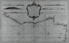 | Details | Bellin, Jacques Nicolas | 1750 |
| Carte Generale De La Coste De Guinee |
|
Bellin, Jacques Nicolas |
|
| 1750 |
| LOC:0 |
| $395.00 | Bellin--Jacques-Nicolas | Carte-Generale-De-La-Coste-De-Guinee | Large working antique nautical chart of African coast focusing on the Gulf of Guinea and Gulf of Benin. Six profile views of the coast of West Africa, just north of the equator. This chart was intended for service aboard French vessels as noted in the cartouche "Pour servir aux vaisseaux du Roy".<BR> </BR>
Large central cartouche framed by strapwork and floral flourishes. This nautical chart was published less than 40 years after the death of Louis XIV, the "sun king" by the Depot des Cartes et Plans de la Marine. |