| | Thumbnail | | Creator | Date | Title / Author / Date / Location | Price | | | Description |
| 788 | 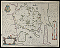 | Details | Blaeu, Johannes | 1640 |
| Antique map of the Danish Island of Fyn in the Baltic Sea |
|
Blaeu, Johannes |
|
| 1640 |
| LOC:0 |
| $0.00 | Blaeu--Johannes | Antique-map-of-the-Danish-Island-of-Fyn-in-the-Baltic-Sea | SOLD
<br></br>
Price includes shipping. Antique map of Fyn ( Funen ) in Denmark. Coverage includes the islands of Fyn ( Funen ), Denmark's third largest island; Langeland; Aeroe / Ærø ( Arr ) ; Als ( Alsen ); and the Western coast of Zeeland. Key cities noted include Odense ( Ottonia or Odensee ); Nyborg; Nackeby; Bogense ( Bowens ); and Hinsgagel, just below Middelfart. To the south lies the Baltic Sea ( Mare Balticum ). Dozens of smaller islands are each colored and are named, most encircling the island of Fyn.
<br></br>
This mid-seventeenth century copper-plate engraved map is characterized by beautiful flowing calligraphy, a vertical mileage scale, French text on the verso, and a title cartouche with two cow-herds surrounded by a herd of cattle. Three small ships under sail fill in the empty areas of the sea. Within the islands, numerous, villages, hills, lakes, rivers are identified by name. Created by prolific Dutch cartographer J. Blaeu from Amsterdam ca. 1640. |
| 3615 | 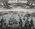 | Details | Bodenher, Gabriel | 1704 |
| Attractive antique birds-eye view of the Oresund with Kronborg Castle and Copenhagen |
|
Bodenher, Gabriel |
|
| 1704 |
| LOC:7 |
| $325.00 | Bodenher--Gabriel | Attractive-antique-birds-eye-view-of-the-Oresund-with-Kronborg-Castle-and-Copenhagen | Fine antique birds-eye view of the Oresund, the sound that separates Seeland (Denmark) from Schonen (Sweden). The copperplate-engraved view by Gabriel Bodenher is from the perspective of a viewer looking south into the north entrance of the Oresund. At the right are Helsingor, Kronborg Castle (Cronenburg), and Copenhagen. At left on the east side of the sound lie Helsingborg (Ellingburg), Landskrona (Lands Croon) and Malmo. Warships bearing flags of several nations are underway heading south in the direction of Copenhagen.
<br></br>
Gabriel Bodenher (1673- 1765) was a German map maker and member of a famous family of Augsburg engravers and publishers. Bodenher is best known for his main work, Atlas Curieux, first published in 1704. |
| 902 | 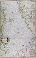 | Details | Lous, Christian Carl | 1794 |
| Chart of the Kattegat, Denmark and Sweden |
|
Lous, Christian Carl |
|
| 1794 |
| LOC:57 |
| $0.00 | Lous--Christian-Carl | Chart-of-the-Kattegat--Denmark-and-Sweden | SOLD
<br></br>
Large, bold sea chart of the Kattegat (Cattegat or Kattegatt), a shallow sea separating Denmark from Sweden. Coverage on this scarce, attractive, and colorful antique British chart includes the Jutland Peninsula, east coast of Denmark from Skagen to past Aarhus and includes the islands of Samsø or Samsoe, Læsø ("Laesso"), and Zealand with Copenhagen at the extreme bottom right. On the opposite side of the Kattegat the west coast of Sweden extends northward past Halstad, Warburg, and Gothenburg and includes the islands of Hisingen ("Hysingen") and Tjorn ("Tiorn").
<br></br>
Includes several coastal profile recognition views in the approaches to Copenhagen, Denmark. During the early 19th century the British fleet twice battled the Danes at Copenhagen, once in 1801 and again in 1807. With three inset small scale port and harbor charts including:
<ul>
<div class="indenttextblock">
<li>A Plan of Maarstrand Harbor with the Neighboring Channels </li>
<li>A Plan of the Entrances into Gothenburg.</li>
<li>The Entrances into Malo Sound within Nidingen.</li>
</div>
</ul>
This edition of the chart is based on the work of Christian Carl (or "Charles") Lous, (1724-1804) a professor and cartographer. Published by Laurie and Whittle. Fleet Street. London. 12th May, 1794. |
| 771 | 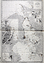 | Details | Depot de la Marine | 1922 |
| Chart of the Oresund from Baltic Sea to Kattegat |
|
Depot de la Marine |
|
| 1922 |
| LOC:0 |
| $0.00 | Depot-de-la-Marine | Chart-of-the-Oresund-from-Baltic-Sea-to-Kattegat | SOLD
<br></br>
Large 90+ year old nautical chart of the Oresund or sound connecting the Baltic Sea to the Kattegat and separating Sweden from Denmark. This plate is a 1922 edition of a French navigational chart first published in 1892. Large inset at left of the Port de Copenhague ( Copenhagen ) Denmark; small insets of Landskrona, Port d'Hoganas, Port de Raa, Port d'Elseneur, Port de Skanor, and Port d'Helsingborg.
<br></br>
Published by the French Naval Hydrographic Service which was the successor to the Dépôt des cartes et plans de la Marine, founded in 1720. In 1971 it became known as the Naval Hydrographic and Oceanographic Service (service hydrographique et océanographique de la marine or SHOM).
<br></br>
Aids to navigation are highlighted in orange. Lower left corner contains two stamps: One inked stamp from the Service Hydrographique and the other a purple sticker from the map seller: "V. Weizsaeker, Opticien de la Marine. 13 Rue du Quai, Dunkerque" |