| | Thumbnail | | Creator | Date | Title / Author / Date / Location | Price | | | Description |
| 6563 |  | Details | Deering, G.G. | 1919 |
| Painting on Gold Leaf Ship Marie Sophie of Falmouth |
|
Deering, G.G. |
|
| 1919 |
| LOC:0 |
| $975.00 | Deering--G-G- | Painting-on-Gold-Leaf-Ship-Marie-Sophie-of-Falmouth | Painting on Gold Leaf of the Schooner Ship Marie Sophie of Falmouth on Masonite and housed in an early frame (painted tan). Original brass hangers. Seller noted: "Unsigned but I believe this was done by Carroll A. Deering son of the owner of the G.G. Deering Shipyard at Bath, Maine (later Bath Iron Works)."
<br></br>
Purchased in 2013 with other Deering memorabilia from 1919.
<br><br>
According to an online article by the National Park Service about the ghost-ship Carroll A. Deering (l. 1919). <div class="indenttextblock"> On January 29, 1921, the ship was making a return trip to Hampton Roads, Virginia from Barbados when she passed the Cape Lookout Lightship. According to the lightship a crewman, who did not look or act like an officer, reported that the ship had lost its anchors.
<br><br>
This was the last report of the ill-fated Deering before she was found run aground and abandoned. At 6:30 am on January 31st, C.P. Brady of the Cape Hatteras Coast Guard Station spotted a five-masted schooner in the morning light, aground and helpless on the shoals…. Upon investigating the ship, it was discovered that all personal belongings, key navigational equipment, certain papers, and the ship’s anchors were missing. Food was laid out as if in preparation for a meal. But there was no sign of the crew.
Source: http://www.nps.gov/caha/historyculture/theghostship.htm</div> |
| 6472 | 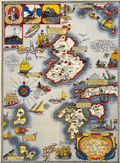 | Details | Shurtleff, Elizabeth | 1927 |
| Rare pictorial map of the Isle of Shoals |
|
Shurtleff, Elizabeth |
|
| 1927 |
| LOC:53 |
| $2,100.00 | Shurtleff--Elizabeth | Rare-pictorial-map-of-the-Isle-of-Shoals | Very rare original full-color lithographed pictorial map of the Isle of Shoals from 1927 designed and drawn by Elizabeth Shurtleff. Copyright by Jessie E. Donahue (1927). Beautiful, saturated colors. With verse by Celia Thaxter and Frederick T McGill.
<br><br>
Only two copies of Elizabeth Shurtleff's 1927 map of the Isle of Shoals were found in WorldCat. No record of a sale of the map was found online. A later much-revised edition of the Shurtleff's map was copyrighted and published in 1960 by Edward Rowe Snow.
<br><br>
Captain John Smith discovered the Isle of Shoals in 1664 lying about seven miles offshore on the border of what are today the states of New Hampshire and Maine. |
| 6417 | 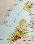 | Details | Marine Board of South Australia | 1885 |
| Lighthouse Map of the Province of South Australia Rare Chart |
|
Marine Board of South Australia |
|
| 1885 |
| LOC: |
| $2,195.00 | Marine-Board-of-South-Australia | Lighthouse-Map-of-the-Province-of-South-Australia-Rare-Chart | A fine, unrecorded edition of the Lighthouse Map of the Province of South Australia January 1, 1885 published by the Marine Board of South Australia, Thomas N. Stevens, Secretary. Inset maps showing light beacons for Port Adelaide River and Port Pirie River. "The Marine Board was responsible for shipping safety, buoys, lighthouses and explosives amongst other functions." [1]
<br><br>
Large format charts of lighthouses displaying graphically the light color, period, and distance visible are very rare. See [2], [3]. For Australia this is the only copy recorded of this map for the 1885 edition. Only three other editions with one copy each (1881, 1883, and 1885) are held in Australian institutions. No copy of the 1885 edition is found anywhere online nor are any sales recorded in AMPR for any copy of this Australian Lighthouse Map.
<br><br>
P.P. No. 43. Lithographed by E. Spiller, Government Printer, Adelaide.
<br><br>
Inset index tables: (1) Reference to Lights with the lighthouse name, color, distance visible, period and other key data for each lighthouse. (2) List of Government Wharves and Jetties Showing Length and Depth of Water at Low Water.
<br><br>
Coverage of this Australian lighthouse chart stretches from Waterloo Bay at the west to Cape Northumberland at the south east. Includes the waters of Spencer Gulf, Separator Strait, Kangaroo Island, and the Gulf of St. Vincent with Port Adelaide.
<br><br>
[1] Encyclopedia of Australian Science. Online: https://www.eoas.info/biogs/P006561b.htm. <br>
[2] BRITISH LIGHTHOUSE CHART OF GENERAL COAST LIGHTS. Compiled from authentic sources by Woolfield H. F. Hardinge. London: J. D. Potter Admiralty Chart Agent, 1874.[3] <br>
[3] A Chart exhibiting the Light Houses and Light Vessels of the Coasts of Great Britain and Ireland and also those on the N.W. coasts of Europe between Ushant and Bergen. Alexander G. Findlay. London. Corporation of Trinity House. Published by R. H. Laurie. 1863. |
| 5282 | 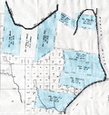 | Details | U.S. Congress | 1837 |
| Antique plat of lands Choctaw Point Lighthouse Mobile Bay Alabama |
|
U.S. Congress |
|
| 1837 |
| LOC:10 |
| $275.00 | U-S--Congress | Antique-plat-of-lands-Choctaw-Point-Lighthouse-Mobile-Bay-Alabama | Scarce plat map of land near Mobile, Alabama from 1837 to support the published opinion of Benjamin Franklin Butler, Attorney General of the United States (1833-1838) in a case dated August 5, 1837. The plat shows the Mobile River at right with Choctaw Point Lighthouse. Lot contains 2 page of legal opinion, supported by the plat, probably from a report to Congress.
<br></br>
Choctaw Point is located on the west bank of the Mobile River about one mile south of downtown Mobile and one mile SW of the U.S.S. Alabama memorial. A brick lighthouse (63' Fixed light), visible for 15 miles, existed at Choctaw Point from 1831 until the beginning of the Civil War. The American Lighthouse Guide of 1845 found the light of little use in navigating the Dog River.
<div class="indenttextblocksingle">
"To mail steamers and bay craft familiar with the shoals, and Choctaw Pass, this light is a valuable aid in dark nights, but of little benefit to strangers. This light is of little utility in consequence of forming too great an angle in its bearing from the courses required through the intricate and narrow channels of the river and passes." (Mills, Robert. The American Light-house Guide: with Sailing Directions, for the Use of the Mariner. 1845. p. 11)
</div>
Among the land holdings near Choctaw Point that are identified in the map are plots belonging to Antoine Espijo, John Forbes & Co., Regist Burnady, Simon Favre, and John Murrill. |
| 5277 | 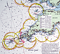 | Details | Stanford, Edward | 1900 |
| Superb late 19th-century nautical chart of the English Channel |
|
Stanford, Edward |
|
| 1900 |
| LOC:1409 |
| $2,575.00 | Stanford--Edward | Superb-late-19th-century-nautical-chart-of-the-English-Channel | A visually captivating and informative original antique 19th-century nautical reference chart of the English Channel with visible extent of lighthouses shown graphically. Uncommon. The few similar items that come to mind are Hardinge's 1874 "British Lighthouse Chart of General Coast Lights", and "A Chart Exhibiting the Light Houses and Light Vessels of the Coasts of Great Britain and Ireland" issued by the Corporation of the Trinity House, 1863.
<br><br>
This antique original, rolled, linen-backed chart, based on data from Lieutenant H.C. Lockyer in 1899, was published by Edward Stanford from Stanford's Geographical Establishment in London on March 1, 1900. Stanford's, established in 1853, remains in business today, now at 7 Mercer Walk in Covent Garden.
<br></br>
Coverage includes relevant portions of the coast of Ireland, Wales, England, and France, with Cornwall near chart center.
<br><br>
Scarce, especially in fine condition as this example. Only one institutional holding in WorldCat.
<br></br>
Contains drawings of the uniform system of buoyage: starboard-hand buoys, port-hand buoys, middle ground buoys; pillar, spar, and gas buoys; and wreck-marking vessels. Of great visual interest are the dozens of lighthouses identified on the chart with the range, frequency, duration, and color of each light provided for navigators. The chart is filled with tide tables, general information, soundings and distances and sailing directions for numerous ports. Topographical detail useful to navigators is shown for coastal locations and for those inland locations where the height of a feature warranted inclusion, e.g. Brecknock Mountain, Wales at 2862 ft. elevation.
<br></br> |
| 4946 | 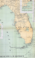 | Details | Lighthouse Board of the United States | 1901 |
| Report of the United States Light-house Board. 1901. |
|
Lighthouse Board of the United States |
|
| 1901 |
| LOC:2001 |
| $475.00 | Lighthouse-Board-of-the-United-States | Report-of-the-United-States-Light-house-Board--1901- | Scarce annual report of the United States Light-house Board for the fiscal year ending June 30, 1901. Folds to 6" x 9".
<br></br>
Contents include:
<div class="indenttextblocksingle">
<ul style="list-style-type: circle;">
<li>Index chart of all lighthouse districts approximately 15" x 18" inside the neatline.</li>
<li>Seventeen colored folding charts of individual lighthouse districts. Unfolded, each chart measures approximately 15" x 18" inside the neatline.</li>
<li>Eleven black and white plates.</li>
</ul>
</div>
</div>
Washington. Government Printing Office. Treasury Department. Document No. 2228. Office of Lighthouse Board. |
| 611 | 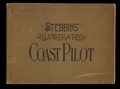 | Details | Stebbins, Nathaniel L. | 1891 |
| First Edition Stebbins' Illustrated Coast Pilot - 1891 |
|
Stebbins, Nathaniel L. |
|
| 1891 |
| LOC:0 |
| $465.00 | Stebbins--Nathaniel-L- | First-Edition-Stebbins--Illustrated-Coast-Pilot---1891 | FIRST EDITION of this antique, late 19th century landmark in coastal navigation from the famous Boston-based marine photographer Nathaniel Stebbins. An interesting late 19th century artifact that combined the (then) new technology of photography with the oldest known form of recorded navigational instructions- the <a href="https://en.wikipedia.org/wiki/Periplus">periplus</a> or book of written sailing directions.
<br></br>
Stebbins's fascinating antique coast pilot first demonstrated the practical application of photography to navigation, a field long dominated by man-made representations of coastal features. Contains numerous photographs of key landmarks and navigational aids accompanied by textual sailing directions. Among the hundreds of photographs are Stepping Stones lighthouse, Execution Rocks lighthouse, Stamford Harbor lighthouse, Bartlett Reef light vessel, Newport Harbor lighthouse, Hen and Chickens light vessel, Vineyard Sound light vessel, Hyannis wharf and range lights, Great Round Shoal light vessel (appears to be a decrepit wreck of a sailing vessel), Nantucket lighthouses at Brant Point and Great Point, and the Boston and Marblehead lighthouses. <BR> </BR>
Includes numerous interesting nautical advertisements. Covers the United States northeast from New York to Maine. <BR> </BR>
We are not aware of an earlier coast pilot containing photographic coastal images. Already scarce, this overlooked volume with a sea-worthy canvas cover belongs in the collection of all those interested in 19th century U.S. coastal charts. Numerous nautical-related advertisements scattered throughout. The author describes this internal advertising as an effort to hold down the cost to the reader. Boston. 1st ed. |
| 149 | 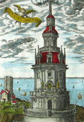 | Details | Tassin, Christophe Nicholas | 1636 |
| Tour de Corduan |
|
Tassin, Christophe Nicholas |
|
| 1636 |
| LOC:0 |
| $350.00 | Tassin--Christophe-Nicholas | Tour-de-Corduan | <b>A recommended item</b> for any collector of maritime, lighthouse, or nautical antiques. Should appeal to collectors of coastal charts of France. Very unusual and quite interesting engraving from Tassin who produced almost exclusively charts and plans of the French coast and little else.
<br></br>
Extremely scarce antique view of the lighthouse "Tower of Corduan" ca. 1636 after an earlier work by Claude Châtillon in 1612. The "Tour de Corduan" is the oldest lighthouse in France and one of the oldest lighthouses in the world. The structure was completed in 1611, more than 35 years after its initial design by Louis de Foix.
<br></br>
Sometimes called the King of Lighthouses because of its large size and extravagant construction details, Le Phare Corduan marks the entrance to the Gironde river near Royan, France. As is common with Tassin engravings numerous sailing vessels are shown offshore the lighthouse, with one firing a blast from its cannon.
<br></br>
Published in the small-sized atlas "Les Plans et profils de toutes les principales villes et lieux considerables de France" by Christophe Nicholas Tassin (d. 1660) . Tassin's background was as a military engineer, and he is best known for his nautical atlas of 30 sheets, dedicated to Richelieu, documenting France's coastline. Tassin's work contains topographic maps, often of militarily important sites, either sketched on site, composed from firsthand drawings by military engineers, or sometimes borrowed from other mapmakers. |
| 705 | 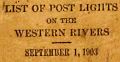 | Details | U.S. Department of Commerce and Labor | 1903 |
| List of Post Lights on the Western Rivers |
|
U.S. Department of Commerce and Labor |
|
| 1903 |
| LOC:0 |
| $165.00 | U-S--Department-of-Commerce-and-Labor | List-of-Post-Lights-on-the-Western-Rivers | Small, antique, pocket size book of lights on all the U.S. Western Rivers corrected to September 1903. Lights are grouped into three sections by Lighthouse District each with a sectional title page. The 3 book sections are:
<div class="indenttextblock"><ul>
<li>Fourteenth District: List of Lights on the Ohio, Kanawa, and Tennessee Rivers.</li>
<li>Fifteenth District: List of Lights on the Mississippi (above Cairo, Ill.) Missouri, and Illinois Rivers.</li>
<li>Sixteenth District: List of Lights on the Mississippi (Below Cairo, Ill.) and Red Rivers.</li></ul></div>
Format is the same throughout: the left page header contains the river name and the starting point from which river channel mileage is measured. Detail columns on left pages capture the light number, official light name, distance from the starting point, side of channel, and color of light. Right facing pages are ruled and blank for use of the reader to record notes; the header reads: "Remarks, Changes, Etc."
<br></br>
Each sectional title page bears a request to readers for help in identifying lights with usability issues: <div class="indenttextblock">"Pilots and all masters are particularly requested to report to the Light-House Inspector at Cincinnati, Ohio, lights which are out or dim or burning during the day; also changes in location of lights required, using the official name and number of the light. Pilots are also requested to blow their whistles when a light is out to notify the keeper."</div>
The Ohio River distances are measured from Pittsburg, Pennsylvania; Kanawa River distances from Point Pleasant; Tennessee River Distances from Paducah, Kentucky; Upper Mississippi River distances from St. Paul, Minnesota; Lower Mississippi River distances are measured starting from Cairo, Illinois.
<br></br>
A few user manuscript pencil entries of birthdays and other notes on the first few notes pages. 253 pages total. |