| | Thumbnail | | Creator | Date | Title / Author / Date / Location | Price | | | Description |
| 1042 |  | Details | Morisot, C.B. | 1643 |
| Japonese Navigum, Sinese Navigum |
|
Morisot, C.B. |
|
| 1643 |
| LOC:1 |
| $175.00 | Morisot--C-B- | Japonese-Navigum--Sinese-Navigum | Single sheet of chain laid paper with an engraved illustration of two Asian sailing vessels from an early work on maritime history by Morisot (1592-1661): "Orbis Maritimi siue Rerum in Mari et Littoribus Gestarum Generalis Historia". The vessels are titled: "Japonese Navigum" and " Sinese Navigum". Both vessels are steered via side mounted steering oars. |
| 1424 | 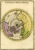 | Details | Mallet, Allain Manesson | 1685 |
| Antique Northern Hemisphere Polar Map |
|
Mallet, Allain Manesson |
|
| 1685 |
| LOC:41 |
| $90.00 | Mallet--Allain-Manesson | Antique-Northern-Hemisphere-Polar-Map | Small, hand-colored antique view of the northern hemisphere from a north polar perspective. Shows the so-called "Arctic Lands" with Greenland connected to northern Canada. Shows Iceland, Spitsbergen, and the "Terre de Iesso" or the Japanese island of Hokkaido . Fig 16.
<br></br>
By Allain Mallet, Paris, 1683 in a German edition of "Description de l'Univers" . Allain Mallet (1630-1706) was a French engineer, soldier, and cartographer. He served in the court of King Louis XIV as a techer of mathematics. In addition to "Description de l'Univers" Mallet also published "Les Travaux de Mars ou l'Art de la Guerre". |
| 1186 | 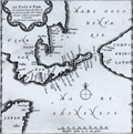 | Details | Aa, Pieter van der | 1719 |
| Scarce Antique Map of Hokkaido, Japan |
|
Aa, Pieter van der |
|
| 1719 |
| LOC:9 |
| $600.00 | Aa--Pieter-van-der | Scarce-Antique-Map-of-Hokkaido--Japan | Antique Dutch map of the island of Eso, today called Hokkaido, the northernmost of Japan's main islands. Printed on a large sheet measuring 19" W x 15" H.
<br></br>
Pieter van der Aa (1659 - 1733) was a Dutch publisher working in Leiden during the early eighteenth century. He is best known for publishing maps and atlases, though he also printed pirated editions of foreign bestsellers and illustrated volumes. From "Nouvel atlas...contenant les principales cartes géographiques dressées suivant les nouvelles observations de Mr. de l'Académie royale des sciences" published in 1714 from Leiden by Van der Aa. Plate number 27 (in manuscript). |
| 1187 | 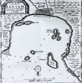 | Details | Aa, Pieter van der | 1719 |
| Scarce Antique Map of Banten in Java Indonesia |
|
Aa, Pieter van der |
|
| 1719 |
| LOC:9 |
| $300.00 | Aa--Pieter-van-der | Scarce-Antique-Map-of-Banten-in-Java-Indonesia | Antique Dutch map of the bay and village of "Bantam" or Banten, Java. Includes a plan of Bantam, and the smaller islands of Pulau Panjang, Groot P. Moby, Poele Don, Cleyn P. Moby, and Hollands kerk-hof. On a much larger sheet of watermarked (with fleur-de-lis), chain laid paper measuring 19" W x 15" H.
<br></br>
Pieter van der Aa (1659 - 1733) was a Dutch publisher working in Leiden during the early eighteenth century. He is best known for publishing maps and atlases, though he also printed pirated editions of foreign bestsellers and illustrated volumes. From "Nouvel atlas...contenant les principales cartes géographiques dressées suivant les nouvelles observations de Mr. de l'Académie royale des sciences" published in 1714 from Leiden by Van der Aa. Plate number 19 (in manuscript). |
| 667 |  | Details | Dalrymple, Alexander | 1890 |
| Plan of the Harbor of Nangasaky ( Nagasaki ) |
|
Dalrymple, Alexander |
|
| 1890 |
| LOC:0 |
| $0.00 | Dalrymple--Alexander | Plan-of-the-Harbor-of-Nangasaky-(-Nagasaki-) | SOLD <br></br>
Very early and scarce chart of the harbor of Nagasaki, Japan by British hydrographer Alexander Dalrymple. Shows a palace complex, the Cavalles, Nombo Point, and a few buildings, along with several dozen soundings. In his doctoral thesis Cook wrote of Dalrymple that he was: <div class="indenttextblock"> "now generally regarded as the originator of official British hydrography… was cumulatively a private publisher of nautical charts and plans (from 1767), the 'examiner of ships' journals' and chart publisher for the East India Company (from 1779), and Hydrographer to the Admiralty (from 1795)". </div>
<br>
Dalrymple attributed the chart to a manuscript by Captain Alexander Hume. That manuscript chart was likely created by Hume while leading a commercial voyage of the East India Company ship "Fox" of 499 tons from March 1761 to July 1763.
<br></br>
First published by Alexander Dalrymple on August 31, 1788. This plate is a re-issue from Dalrymple's original copper plate and bears the stamp of the British Hydrographic Office: late 19th century or possibly early 20th century. Production of Dalrymple's charts continued after his death in 1808. Cook lists this chronology for publication of the chart: <div class="indenttextblock">"[The chart was] re-issued by Hurd after 1810; included in Admiralty Chart catalogues 1825-1855, and allocated chart number 1035; withdrawn before 1857.The printing plate is preserved in the Hydrographic Office."</div>
<br>
<div class="indenttextblock">Reference: Cook, Andrew S., <b>Alexander Dalrymple (1737 - 1808) Hydrographer to the East India Company and to the Admiralty; as publisher: A Catalogue of Books and Charts. </b> Vol. 3 .Doctoral Thesis, University of St. Andrews. 1992.</div> |
| 857 | 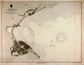 | Details | U.S. Navy Hydrographic Office | 1891 |
| Antique Nautical Chart of Yokohama Bay, Japan |
|
U.S. Navy Hydrographic Office |
|
| 1891 |
| LOC:59 |
| $225.00 | U-S--Navy-Hydrographic-Office | Antique-Nautical-Chart-of-Yokohama-Bay---Japan | Antique nautical chart of Yokohama Bay, Japan produced by the U.S. Navy Hydrographic Office in 1891. Yokohama, a Japanese city south of Tokyo, in 1859 was one of the first Japanese ports opened to foreign trade.
<br></br>
Selected aids-to-navigation are highlighted in yellow including Hommoku Light Ship and two lights at the end of the harbor breakwater. Details ashore include a railroad line running along the shore, a public garden, a fort, the Grand Hotel, an area designated "foreign settlement", the French Hatoba (wharf or quay) , the English Hatoba, and the English Naval Store-house.
<br></br>
Detailed U.S. harbor charts of Japan, like this example are scarce during this time period less than 50 years after Commodore Matthew Perry's expedition to Japan in the mid 1850's. Contains the circular logo of the U.S. Navy Hydrographic Office. |
| 604 |  | Details | Toshihide, Migita | 1900 |
| Russo-Japanese War Triptych |
|
Toshihide, Migita |
|
| 1900 |
| LOC:0 |
| $850.00 | Toshihide--Migita | Russo-Japanese-War-Triptych | Scarce Japanese nautical woodblock print from the Japanese artist Migita Toshihide (1863 - 1925) who is well known for his woodblock prints depicting both the Russo-Japanese war and the later Sino-Japanese war. This print (ca. 1900 ) depicts Japanese sailors on the deck of a sinking vessel struggling with a small boat as they are illuminated by a spotlight. Strong, stylized depiction of breaking waves. Rising sun in the background.
<br></br>
Matted and framed with a simple 1/2" molding for an overall size of approximately 33" W x 19" H. |
| 4733 | 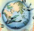 | Details | Asahi Shimbun | 1926 |
| Fine Japanese inter war sugoroku biplane flight game board |
|
Asahi Shimbun |
|
| 1926 |
| LOC:0 |
| $165.00 | Asahi-Shimbun | Fine-Japanese-inter-war-sugoroku-biplane-flight-game-board | Very attractive and decorative Japanese Taisho period inter-war sugoroku board game with pictures of biplanes. This large sugoroku commemorates a record long flight to Europe in July 1925 via the route of Tokyo-Paris-London. The flight, with two Breguet 19 A2 biplanes, was sponsored by the Asahi Shimbun newspaper and piloted by H. Abe and K. Kawachi, covering 13,800 km (8,575 mi).
<div class="indenttextblock">
The Bréguet XIX was two-seater light bomber and as a reconnaissance aircraft, first rolled out in 1923. A very successful metal biplane, it stayed in operational service for fifteen years.
(Source Online: http://acepilots.com/pioneer/breguet19.html)
</div>
</BR>
Set across a background of Asia, locations on the board correspond to cities in Asia and Europe to include Rome, London, Paris, Istanbul and many more. Text in Japanese. Verso is blank.
<br></br>
E-sugoroku, with rules similar to the game of chutes and ladders, appeared in Japan as late 13th century and became popular due to the cheap and elaborate wooden block printing technology of the Edo period. Sugoroku boards were made with pictures and themes from religion, political, actors, heroes, and popular culture. |
| 5200 | 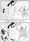 | Details | Army Bureau of Current Affairs | 1945 |
| Wartime pictorial maps one week after A-bombs on Japan |
|
Army Bureau of Current Affairs |
|
| 1945 |
| LOC:62 |
| $475.00 | Army-Bureau-of-Current-Affairs | Wartime-pictorial-maps-one-week-after-A-bombs-on-Japan | Large wartime pictorial poster issued less than one week after the United States used nuclear weapons on Hiroshima and Nagasaki, Japan. This issue, with a heavy emphasis on use of maps to communicate the progress of the war, was the first such to be issued by the [British] Army Bureau of Current Affairs (ABCA) after the United States dropped atomic bombs on Hiroshima and Nagasaki on August 6 and 9 respectively. The issue was published 3 days before Emperor Hirohito announced the total Japanese surrender on national radio.
<br></br>
The maps reflect the importance of the A-bomb to Allied war efforts and the hastiness with which this publication was revised before publication. No photographs or illustrations are present that show the mushroom cloud or the aftermath of the attacks. The verso contains text that does not reflect the news about the bomb: " … the counter invasion of this island empire [East Indies] has begun."
<br></br>
Printed on both sides:
<div class="indenttextblocksingle">
<ul style="list-style-type: circle;">
<li><b>Recto:</b> Headings include "The close of 14 years of Jap aggression" with six inset pictorial maps charting Japanese aggression from 1933 to 1945. Japan's early successes and later defeat are reflected in the image of a sword-bearing Japanese soldier who grows fat with success and then thin with defeat. Also, photographs of the British Cabinet and news from the Potsdam conference.</li>
<li><b>Verso:</b> "Riches of the Southern Seas". Large black and white pictorial map focused on the strategic value of key commodities in the Netherlands East Indies. Map contains pictograms for oil, rubber, rice, tin, and vegetable oils. </li>
</ul>
</div>
ABCA MAP Review No. 72 From July 30th to August 12th, 1945. Drawn and issued by the Army Bureau of Current Affairs. Printed for H.M. Stationery Office by Fosh & Cross Ltd., [1945]
<br></br>
No copies of this issue found online. Scarce. |
| 6661 | 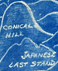 | Details | Henshell, J. | 1945 |
| Cyanotype pictorial map of Okinawa, Japan post WWII |
|
Henshell, J. |
|
| 1945 |
| LOC:86 |
| $350.00 | Henshell--J- | Cyanotype-pictorial-map-of-Okinawa--Japan-post-WWII | This is an original, rare cyanotype blueprint map, self published by J. Henshell, likely a soldier stationed on Okinawa, Japan. It depicts a birds-eye view of the Island of Okinawa, Japan and is dated November 1945, just three months after the surrender of Japan, or V-J Day (1). Henshell's design showcases his appreciation for local Okinawan art and culture, depicting shrines, temples, and tombs in a local artistic style. Local airfields and airbases are shown in rectangular boxes (e.g. Kadena, Futema, Yontan). After a Japanese Imperial Land Survey conducted in 1931.
<br><br>
The design also highlights the hills that played a significant role in the Battle of Okinawa. The island's rugged terrain made them difficult to attack. American forces faced fierce resistance from entrenched Japanese defenders during the battle. Henshell labels three of these key locations: Sugar Loaf Hill, the Conical Hill (Mount Yaedake), and the Japanese Last Stand.
<br><br>
Sugar Loaf Hill was a heavily fortified Japanese defensive position that played a significant role in the Battle of Okinawa. Today, it is a peaceful park and memorial site called the Okinawa Peace Memorial Park. The transformation of Sugar Loaf Hill from battlefield to symbol of peace is a testament to the strength of the people of Okinawa.
<br><br>
Mount Yaedake, also known as Conical Hill, was a key location in the Battle of Okinawa during World War II, as it was heavily fortified by Japanese defenders and provided a natural defensive position. Today, Mount Yaedake is a popular tourist destination, known for its stunning views of the surrounding area.
<br><br>
<div class="indenttextblock">
(1) Nakagusuku Bay, located on the eastern coast of Okinawa, was renamed Buckner Bay in honor of Lieutenant General Simon Bolivar Buckner Jr., who served as commanding General US Army's 10th Army Division during the Battle of Okinawa. Buckner was the highest-ranking US officer to be killed during the battle.
</div> |