| | Thumbnail | | Creator | Date | Title / Author / Date / Location | Price | | | Description |
| 1449 | 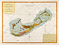 | Details | Lempriere, Clement | 1775 |
| Bermuda or Summer's Island West-India Atlas Lempriere Jefferys Sayer |
|
Lempriere, Clement |
|
| 1775 |
| LOC:51 |
| $4,500.00 | Lempriere--Clement | -Bermuda-or-Summer-s-Island-West-India-Atlas-Lempriere-Jefferys-Sayer | <div class="indenttextblock">
"This coast is the boldest in Bermuda and in some places the Largest Ships may with safety come within half gun shot of shore."
</BR></BR>
"Here in the months of March, April, and May they Fish for Whales."
</div>
</BR>
Above are a few of the notes from this fine antique chart of Bermuda. An extremely desirable British chart titled: "The Bermuda's or Summer's Islands." After a survey by Clement Lempriere. This is from the scarce <b>first issue of The West-India Atlas, 1775 by Sayer</b>, the other issues being 1781, 1787, 1794, 1796, 1807, and 1818 published by Sayer and later Laurie and Whittle.<a href="https://www.davidrumsey.com/home" target="_blank">(Online).</a>
<br></br>
On age-appropriate laid watermarked paper with a fleur-de-lis surmounted by a crown
<br></br>
During Bermuda's colonial period ca. 1615 the island was divided into eight equally-sized administrative areas west of St. George's called <b>"tribes" (parishes)</b>. These "tribes" were areas of land partitioned off to the principal investors of the Somers Isles Company.
<br></br>
From: "The West-India Atlas: or, A Compendious Description of the West-Indies: illustrated with Forty Correct Charts and Maps, taken from Actual Surveys. …"
Authors: Clement Lempriere (original survey), Thomas Jefferys.
Publishers: Robert Sayer.
Jefferys died in 1771; Sayer acquired Jefferys' materials in preparation for this atlas, and published the atlas posthumously under his name. |
| 1461 | 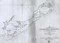 | Details | Hurd, Thomas Hannaford | 1827 |
| Hurd's Very Rare Chart of Bermuda |
|
Hurd, Thomas Hannaford |
|
| 1827 |
| LOC:0 |
| $0.00 | Hurd--Thomas-Hannaford | Hurd-s-Very-Rare-Chart-of-Bermuda | SOLD <br></br>
Thomas Hurd's (1747-1823) rare reduced chart of Bermuda, the first exact survey of the island’s waters. This original antique chart was first issued 30 years after its completion in 1797. One reason the chart may have escaped publication for such a long period was that the Admiralty feared losing valuable hydrographic information to the United States.
<br></br>
After the Revolutionary War, British Canada was cut off from Britain's Caribbean colonies through the loss of access to American ports that once belonged to the British Crown. Bermuda's central position in the Atlantic became of strategic importance.
<br></br>
<div class="indenttextblock">"Hurd's charts revealed several deep channels and anchorages 'large enough for all the navies of the world to ride in," and in 1795 the seventy-four-gun Resolution became the first ship-of-the-line to shelter at Bermuda."
<br></br>
"The task took him nine years to complete and the results of his monumental study altered Bermuda for ever. Hurd’s survey underscored the maritime and strategic capability of Bermuda and by the early 19th century the island was becoming the Gibraltar of the Atlantic, remaining Britain’s largest overseas naval base until after WWII. "
<a href="http://www.royalgazette.com/editorials/article/20160415/bermudas-mapping-that-changed-atlantic-world" target="_blank">(Online.)</a>
</div>
<br></br>
Only two institutions are recorded as holding Hurd's chart: the Royal Museums Greenwich, and Princeton, University. No record of a sale of Hurd's map in AMPR and as of 1/20/18 this is the only copy of Hurd's chart offered for sale online.
<br></br>
With the oval fouled-anchor logo of the Hydrographical Office of the Admiralty. Attribution reads: "London : Published according to Act of Parliament at the Hydrographical Office of the Admiralty, 4th. Augt. 1827." Price two shillings. |
| 5152 | 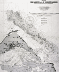 | Details | British Admiralty Hydrographical Office | 1918 |
| Chart of eastern Bermuda Islands St. Georges |
|
British Admiralty Hydrographical Office |
|
| 1918 |
| LOC:54 |
| $450.00 | British-Admiralty-Hydrographical-Office | Chart-of-eastern-Bermuda-Islands-St--Georges | Antique engraved British Admiralty chart of the eastern Bermuda Islands-- St. George's Island, Paget Island, Smith's Island, and St. David's Island. Shows roads and buildings then existing in St. George's Town and the channel dredged into St, George's Harbor in 1916 and 1917. Edition of February, 1918.
<br></br>
This navigational chart of Bermuda was published in July 1897, but 1918, under the superintendence of Rear Admiral W. J. L. Wharton. Engraved by Davies and Company. Sold by J.D. Potter, London.
<br></br>
Chart number 1315. |
| 5040 |  | Details | H. R. Elliot and Co. Inc. | 1937 |
| Map of Bermuda Merrily we go around |
|
H. R. Elliot and Co. Inc. |
|
| 1937 |
| LOC:10 |
| $175.00 | H--R--Elliot-and-Co--Inc- | Map-of-Bermuda-Merrily-we-go-around | Cute pictorial map of Bermuda: "Merrily we go around. " Four panel brochure with an Illustration of a train and a pirate are featured next to the title cartouche. Verso with advertisements. Not dated but ca. 1937.
<br></br>
Published and printed by H. R. Elliot and Co. Inc., New York, N. Y. Provided courtesy of Bermuda. Size within the neatline 17" W x 7 H. |
| 4814 | 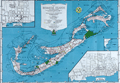 | Details | Bell, Euphemia Young | 1945 |
| Map of The Bermuda Islands alias Somers Islands |
|
Bell, Euphemia Young |
|
| 1945 |
| LOC:0 |
| $120.00 | Bell--Euphemia-Young | Map-of-The-Bermuda-Islands-alias-Somers-Islands | Colorful and very attractive map of Bermuda: "Map of The Bermuda Islands alias Somers Islands". The map was created by Euphemia Young Bell and published by 'Beautiful Bermuda' Publishing Co. as the front of a single-sheet brochure with numerous local Bermuda advertisements populating the verso. Publication of the book coincides with the end of World War II which marked the beginning of steady, sustained economic prosperity for Bermuda.
<br></br>
Folding map (8" x 6" folded) was copyrighted by Frank R. Bell in 1945 and sold with a cover as "The Standard Road and Railroad Map of the Beautiful Bermuda Islands." Inset maps of the City of Hamilton, and the Town of St. George. Large index of Places and Points of Interest including these categories:
<div class="indenttextblock">
<ul style="list-style-type: circle;">
<li>Airports</li>
<li>American Consulate General</li>
<li>Banks</li>
<li>Bicycle Garages</li>
<li>Churches</li>
<li>Ferry Landings</li>
<li>Golf Links</li>
<li>Government Offices</li>
<li>Guest Houses</li>
<li>Hospital</li>
<li>Hotels</li>
<li>Lodges and Clubs</li>
<li>Motor Fuel</li>
<li>Newspaper Offices</li>
<li>Public Utilities</li>
<li>Restaurants, etc.</li>
<li>Sightseeing</li>
<li>Theaters</li>
<li>Transportation Offices</li>
<li>Visitor's Information</li>
<li>Railway Stations</li>
</ul>
</div></div>
Lithographed by Hagstrom Company, Inc. N.Y. Map Makers. Seller's ink stamp on the cover. |