| | Thumbnail | | Creator | Date | Title / Author / Date / Location | Price | | | Description |
| 1079 | 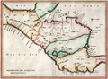 | Details | Herrera y Tordesillas, Antonio de | 1622 |
| Scarce 1622 map of Central America including Costa Rica |
|
Herrera y Tordesillas, Antonio de |
|
| 1622 |
| LOC:10 |
| $600.00 | Herrera-y-Tordesillas--Antonio-de | Scarce-1622-map-of-Central-America-including-Costa-Rica | Scarce map of the "Audiencia" or province of "Guatimala", then comprised of southern Mexico, Honduras, El Salvador, Nicaragua, Costa Rica, and Belize. From "Descripción de la Audiencia de Guatemala, compuesta por el Licenciado Don Antonio de Remesal, del Consejo de Su Majestad, su Oidor y Relator, año de 1618" by Antonio de Herrera y Tordesillas. In the "Descripción de la Audiencia de Guatemala," Herrera y Tordesillas covers a wide range of topics, including the geography and climate of the region, the indigenous peoples who lived there, and the Spanish efforts to establish colonial rule. He also provides detailed accounts of the major cities and towns, as well as the various institutions that made up the colonial administration.
<br></br>
Some of the locations noted on the map include: the Gulf of Fonseca, San Miguel, San Salvador, Santiago de Guatemala, Chiapa de Corzo, Soconusco, the Gulf of Honduras, Puerto Cortes (Puerto de Caballos); Trujillo; and the islands of Coiba and Cébaco, Panama. In Costa Rica, Herrera y Tordesillas identifies among other features: Nicoya, Isla de Chira, Cartago (16 mi. east of San Jose), and El Castillo (near the Arenal volcano). |
| 5439 | 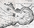 | Details | Dampier, Wllliam | 1704 |
| Rare chart of the Gulf of Nicoya Costa Rica |
|
Dampier, Wllliam |
|
| 1704 |
| LOC:78 |
| $0.00 | Dampier--Wllliam | Rare-chart-of-the-Gulf-of-Nicoya-Costa-Rica | SOLD<br><br>Rare chart from 1704 of the Gulf of Nicoya in Costa Rica from an account of his "Voyage Round the World" by William Dampier (1651 - 1715).
<br></br>
The Gulf of Nicoya lies on the west coast of Costa Rica, about 50 miles from San Juan, the capital city. |
| 1345 | 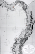 | Details | British Admiralty Hydrographical Office | 1929 |
| Antique Nautical Chart of Costa Rica, Panama, Colombia and Equador |
|
British Admiralty Hydrographical Office |
|
| 1929 |
| LOC:0 |
| $225.00 | British-Admiralty-Hydrographical-Office | Antique-Nautical-Chart-of-Costa-Rica--Panama--Colombia-and-Equador | Large, graphically striking, antique engraved British Admiralty sea chart of the Pacific coast extending from the Gulf of Dulce, Costa Rica, through all of Panama, and down the west coast of Colombia and Equador. The beauty of this chart lies in the extensive and bold engraving of mountain ranges and other topographical details.
<br></br>
Numerous lighthouses are picked out with red or yellow highlights. Last corrections made in manuscript with red ink.
<br></br>
First published by the Admiralty from London in August 1903 under the superintendence of Royal Navy Hydorgrapher Rear Admiral Wharton. This very attractive edition of the scarce Admiralty chart was printed with last corrections to 1929.
<br></br>
Sold by J.D. Potter Agent for The Admiralty. |