| | Thumbnail | | Creator | Date | Title / Author / Date / Location | Price | | | Description |
| 8058 |  | Details | Boston Water Board | 1889 |
| Boston Water Works Blueprint Plan 1889 Sudbury Cochituate Mystic Water Supply Diagram |
|
Boston Water Board |
|
| 1889 |
| LOC:41 |
| $375.00 | Boston-Water-Board | Boston-Water-Works-Blueprint-Plan--1889-Sudbury-Cochituate-Mystic-Water-Supply-Diagram | |
| 8053 | 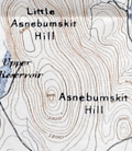 | Details | Appalachian Mountain Club | 1891 |
| Map of the Country About Worcester Compiled by Appalachian Mountain Club |
|
Appalachian Mountain Club |
|
| 1891 |
| LOC: |
| $1,100.00 | Appalachian-Mountain-Club | Map-of-the-Country-About-Worcester-Compiled-by-Appalachian-Mountain-Club | A scarce regional map of central Massachusetts titled <i>Map of the Country About Worcester</i>, published in 1891 by the Appalachian Mountain Club. The map is a sister publication to the Club’s <i>Map of the Country About Boston</i>, issued a year earlier in 1890, and extends AMC coverage westward from the Boston basin into the uplands and river valleys of interior Massachusetts. Only six institutional holdings are recorded in WorldCat, underscoring the map’s scarcity.<br><br>
The maps were compiled from multiple U.S. Geological Survey quadrangle sheets and reduced to a uniform scale. Together, the two sheets extend the Appalachian Mountain Club’s regional mapping beyond the Boston basin into central Massachusetts. Their production reflects the Appalachian Mountain Club’s effort to adapt official government mapping into practical regional maps suitable for recreational, educational, and reference use.<br><br>
The Worcester map appeared in 1891, the same year that <i>The Trustees of Public Reservations</i> was founded, marking a pivotal moment in Massachusetts conservation history. Both initiatives were closely associated with Charles Eliot, an early member of the Appalachian Mountain Club who became its Councilor of Topography in 1890 and was a leading advocate for systematic landscape preservation.<br><br>
As stated in the imprint, the map was “Published by the Appalachian Mountain Club from the proofs of the State map with the permission of the director of the United States Geological Survey and the Commissioners of the Topographic Survey of Massachusetts.” The sheet was lithographed by George S. Harris and Sons, with sales agents W. B. Clarke and Company of Boston and Putnam and Davis, Booksellers, Worcester. |
| 8047 | 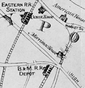 | Details | Little, N. Jr. | 1875 |
| Map of mining lands at Newbury, near Newburyport, Essex County, Massachusetts |
|
Little, N. Jr. |
|
| 1875 |
| LOC:41 |
| $950.00 | Little--N--Jr- | Map-of-mining-lands-at-Newbury--near-Newburyport--Essex-County--Massachusetts | An original late 19th century survey map titled "Map of Mining Lands at Newbury, Near Newburyport, Essex County, Massachusetts", formally entered according to Act of Congress in 1875. Issued separately in a small covered booklet. Drawn by N. Little Jr., the sheet presents a large-scale depiction of the marshlands, waterways, and adjoining uplands of the lower Merrimack and Parker River region. Not much is known about Little but several parcels of land on the map are attributed to N. Little Jr. making the author a very interested stakeholder in the maps' creation and publication.
<br><br>
Executed at a scale of 125 rods to one inch, the map delivers a level of practical detail associated with cadastral and engineering surveys rather than general town mapping. A decorative compass rose anchors the composition at left, while clearly defined town boundaries identify West Newbury, Newbury, Rowley, and Georgetown, with Newburyport situated prominently along the Merrimack River corridor.<br><br>
The map is especially informative in its integration of natural geography, transportation infrastructure, and parcel-level land division. The Merrimack River spans the upper portion of the sheet with the Newbury Flats labeled along the riverfront, while the eastern extent reaches to the Plum Island River, Plum Island, and the Atlantic Ocean, including Salisbury Beach. The Parker River winds through the lower right quadrant, fed by numerous named creeks and surrounded by finely stippled marshland drainage. Two railroad lines, the Eastern Railroad and the Boston and Maine Railroad, are clearly drawn and labeled, reinforcing the economic context of the survey. Throughout the central and southwestern areas, dense subdivision lines and owner-name annotations document individual parcels within the designated mining lands, confirming the map’s function as a legal and developmental instrument rather than a purely descriptive view of the region.<br><br> |
| 8039 | 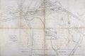 | Details | Mason, W.A. | 1887 |
| Unrecorded Manuscript Trace Cambridgeport Lands Frederick Lothrop Ames |
|
Mason, W.A. |
|
| 1887 |
| LOC:1401 |
| $2,750.00 | Mason--W-A- | Unrecorded-Manuscript-Trace-Cambridgeport-Lands-Frederick-Lothrop-Ames | A large, unrecorded pen and ink trace map on tracing cloth depicting lands on the Charles River Flats then held by the estate of Frederick Lothrop Ames (1) and associated owners, on the site now occupied by the Massachusetts Institute of Technology. The map was copied by William H. Whitney after Mason in the same month that the Massachusetts Legislature passed legislation that forced the cities of Cambridge and Boston to build the Harvard Bridge and share costs (2). Some portion of the map is attributed in pencil to a blueprint in Ames' possession, likely by W. A. Mason. Verso with the oval blue ink overstamp of William H. Whitney and index number 313.
<br><br>
The map was prepared in 1887, at a moment when the Charles River Embankment Company had begun construction of its granite seawall and was actively filling the Charles River Flats with dredged material from the river. It shows significant detail of the hydrography of the area including height in feet above low water at spring tide and the course of several small waterways including a detailed survey of Goff's Cove.
<br><br>Using the west line of the proposed Main Street extension, later realized as the Harvard Bridge, as a fixed boundary, and reading the notation on the mapped boundary, it appears Ames had already deeded lands west of this line to the Embankment Company. This drawing would have served as the working basis for negotiations over the remaining eastern portion of the Flats still under his ownership.
<br><br>
The sheet approximately covers the Charles River Flats from the navigable canal on the east to Goff's Cove on the west, and from the Boston and Albany Branch Railroad south to the planned 200 foot parkway along the riverbank. Detailed annotations at center record precise parcel boundaries totaling more than 2.3 million square feet and specify the fractional ownership interests of four parties, including Ames and the Charles River Embankment Company. Scale 80 feet to 1 inch.
<br><br> |
| 8020 |  | Details | White Mountain Graphics | 1981 |
| Illustrated Pictorial Map of Martha’s Vineyard |
|
White Mountain Graphics |
|
| 1981 |
| LOC:130 |
| $300.00 | White-Mountain-Graphics | Illustrated-Pictorial-Map-of-Martha’s-Vineyard | A colorful illustrated poster map of Martha's Vineyard drawn by K. Rinaldo and published in 1981 by White Mountain Graphics. The poster is filled with hundreds of hand-drawn vignettes capturing island towns, harbors, beaches, landmarks, and summer pastimes. The artist uses a cartoonlike style to show ferries approaching Vineyard Haven, sailboats in Katama Bay, lighthouses, beaches, farms, and well-known establishments across Oak Bluffs, Edgartown, and Chilmark. Inset scenes, handwritten labels, humorous details, and decorative border elements give the sheet the character of a personal visual tour rather than a formal cartographic product.
<br><br>
The map functions as a record of Vineyard culture, highlighting cottages, inns, restaurants, bicycle routes, fishing spots, and community traditions that defined the island during the period. Its composition rewards close viewing, with dozens of local references rendered in a bright palette intended to evoke the island's summer energy. A striking pictorial map for collectors of Vineyard ephemera and American resort-town cartography.
<br><br>
White Mountain Graphics was a small New Hampshire-based illustration and design studio active primarily in the late 1970s and early 1980s. Operating out of Jackson, New Hampshire, the firm produced a range of commercially printed posters, pictorial maps, and souvenir-oriented visual materials, often in a hand-drawn style similar to the Martha's Vineyard map.
<br><br> |
| 7934 |  | Details | Ferran, Arch | 1947 |
| Humorous pictorial map of Concord, Massachusetts |
|
Ferran, Arch |
|
| 1947 |
| LOC:41 |
| $200.00 | Ferran--Arch | Humorous-pictorial-map-of-Concord--Massachusetts | This pictorial map of Concord, Massachusetts and Vicinity was created by Arch Ferran in 1947 and distributed as a complimentary map by the South Bridge Boat House, Inc. The design captures the charm of postwar New England tourism with stylized illustrations of landmarks, forests, and waterways surrounding Concord. The map celebrates both Concord’s rich Revolutionary War history and its literary heritage, presenting the town as a place of reflection, recreation, and natural beauty. Artistic vignettes of trees, bridges, canoes, and historic homes lend a storybook quality to the region’s geography.
<br><br>
The composition balances historic Concord’s landmarks—such as the Old North Bridge, the Minute Man Statue, and the Old Manse—with the scenic rivers and countryside that made the area famous among writers like Emerson and Thoreau. Roads radiate outward toward neighboring towns including Bedford, Carlisle, Sudbury, and Lincoln, creating a sense of exploration beyond Concord’s borders. The inclusion of small figures, animals, and recreational scenes reflects the local popularity of canoeing, hiking, and sightseeing, all centered on the South Bridge Boat House, a long-standing hub for outdoor activities on the Assabet and Sudbury Rivers.
<br><br>
At the upper right, the cartographer cleverly distinguishes True North and Magnetic North, acknowledging the map’s playful yet practical intent. The legend identifies key cultural and natural attractions, helping tourists locate historic homes, churches, and mills. Issued at a time when automobile tourism was flourishing, this map served both as a navigational aid and as a souvenir, capturing mid-century nostalgia for Concord’s enduring role in America’s founding and literary imagination.
<br><br> |
| 6814 | 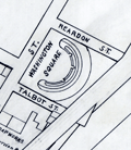 | Details | Whitney, William H. | 1905 |
| Manuscript engineers trace map of Cambridgeport Massachusetts |
|
Whitney, William H. |
|
| 1905 |
| LOC: |
| $500.00 | Whitney--William-H- | Manuscript-engineers-trace-map-of-Cambridgeport-Massachusetts | Original manuscript trace map by the civil engineering firm of William H. Whitey, Boston. A traced pen and ink map on tracing cloth of an area in Cambridgeport, Massachusetts bounded by the Charles River to the south and Erie Street to the North and from Magazine Street at the west to roughly where Briggs Field now stands. This manuscript trace would have been used to create numerous blueprint copies for Whitney's clients. Whitney was a very early adopter of blueprinting to support his map-making and design business.
<br><br>
The map shows the location of the Boston University Bridge across the Charles River then under construction as well as the proposed location for an additional bridge downstream.
<br><br>
Includes Washington Square, a soap works of J. Reardon and Sons, Hastings Square, Morse School, Captain's Island Playground, Baptist home, and Lammson Memorial Building. By William H. Whitney, Boston Civil Engineer. |
| 6823 | 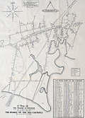 | Details | Harris, Charles E. | 1939 |
| Rare Pictorial Map of Hyannis, Massachusetts Homes of Sea Captains in 1854 |
|
Harris, Charles E. |
|
| 1939 |
| LOC:87 |
| $395.00 | Harris--Charles-E- | Rare-Pictorial-Map-of-Hyannis--Massachusetts-Homes-of-Sea-Captains-in-1854 | A very rare unrecorded historical map of the village of Hyannis, Massachusetts in 1854 showing the locations of sea captains' homes. Copyrighted in 1939 by Dr. Charles E. Harris.
<br><br>
No copies are recorded in WorldCat, nor were any copies found online as of August, 2023.
<br><br>
Includes a alphabetical indexed table of names of sea captains tied numerically to locations Harris has identified on the map. A brief glance at the captains' names makes it apparent that command of Hyannis-based vessels during that time period was largely a familial occupation. Families with the most numerous seafarers included the surnames: Baker (10), Baxter (9) Bearse (23), Crowell (17), Hallett (22), and Lothrop (8). A legend above the table identifies each name with the type of maritime trade each captain was associated with: coastal, deep water, lighthouse service, canal boat, pilot, steamer, and living.
<br><br>
Dated January 1, 1939. Data collected and assembled by Dr. Charles E. Harris. Map courtesy of James F. McLaughlin C.E. Drawn by Walter M. Gaffney. |
| 6827 | 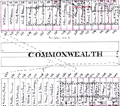 | Details | Fuller and Whitney | 1882 |
| Rare manuscript surveyors cadastral plan of Commonwealth Avenue in Boston Mass |
|
Fuller and Whitney |
|
| 1882 |
| LOC: |
| $850.00 | Fuller-and-Whitney | Rare-manuscript-surveyors-cadastral-plan-of-Commonwealth-Avenue-in-Boston-Mass | If you collect antique Boston paper or you are looking for an original, unique, one-of-a-kind gift for someone then consider this rare piece of Boston history:
<br><br>
This is a manuscript or hand drawn plan, a cadastral map of Commonwealth Avenue in Back Bay, Boston, Mass. from January, 1882. The map was the source map, a master map, a base map, for blueprint copies made around 1882 by the Civil Engineering firm of Fuller and Whitney who styled themselves "Back Bay Engineers". Fuller and Whitney tracked the owners name, lot width and lot number on Commonwealth during the fill and development of Boston's Back Bay in the latter half of the 19th century. Covers five blocks on Commonwealth Ave. between Dartmouth Street and West Chester Park, now called Massachusetts Ave.
<br><br>
Fuller and Whitey regularly used this master copy to publish beautiful blueprints tracking the progress of the Boston Back Bay project in the 1880's. To produce a blueprint they would lay a sheet of tracing paper across this master page and have a draftsman neatly trace and letter the plan in water-soluble ink. When that trace was complete they laid the trace across a sheet of unexposed blueprint paper and placed both sheets under the bright sun for several minutes to expose it, just like an old style contact photograph. The exposed print was then washed to develop it.
<br><br>
Although multiple blueprints may have been produced (I don't know of any) this is the only master manuscript source plan. They aren't making any more of these.
<br><br>
What a conversation piece! Includes notes from the engineers about the how the owner's names were put on the map and about lot widths.
<br><br>
Fuller and Whitey's document index file numbers 741 and 858.
<br><br>
<b>Other Boston manuscript maps are available. Contact us for more information.</b> |
| 6730 | 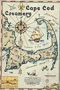 | Details | Gaffney, Walter M. | 1933 |
| Pictorial advertising map for the Cape Cod Creamery |
|
Gaffney, Walter M. |
|
| 1933 |
| LOC:13 |
| $550.00 | Gaffney--Walter-M- | Pictorial-advertising-map-for-the-Cape-Cod-Creamery | Historical pictorial map for Cape Cod Creamery ca. 1933 by Walter M. Gaffney. An unrecorded advertising piece for Cape Cod Creamery, associated with Noble's milk. On heavy card stock. Maps numerous historical and geographic locations including Pilgrim Monument, the Highland Light, Pleasant Bay, the Sandy Neck Light, the Cape Cod Canal. Scattered in each corner is a logo for Noble's milk, the map shows several delivery trucks labeled "Noble's that's good milk", and the large compass rose with a bottle of milk arranged at the center. Small piece of contiguous card stock apparently fashioned into a print hanger suggests the piece may have been trimmed into this shape by a previous owner.
<br><br>
Includes Buzzards Bay, Duxbury Bay, Provincetown Harbor, Wellfleet Harbor, Barnstable Harbor, Pleasant Bay, and a portion of Nantucket Sound.
<br><br>
<div class="indenttextblocksingle">
"Wellfleet or Whalefleet as it was originally called undoubtedly surpassed other towns. In 1843 a whale was captured near the end of the Cape and estimated to contain 200 barrels of oil and 2000 pounds of bone. Only 125 barrels of oil and 300 lbs. of bone were saved but with this waste it netted $10,000."
</div>
<br><br>
Gaffney is also credited with a larger pictorial map of Cap Cod 1932, in a different style, less historically oriented. |
| 6687 | 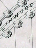 | Details | Olmsted, F. L. and Company | 1889 |
| F.L. Olmsted heliotype landscape plan Linwood Lynn Massachusetts |
|
Olmsted, F. L. and Company |
|
| 1889 |
| LOC:50 |
| $875.00 | Olmsted--F--L--and-Company | F-L--Olmsted-heliotype-landscape-plan-Linwood-Lynn-Massachusetts | Rare finely-detailed heliotype (1) plat and landscape plan by Frederick Law Olmsted for the Linwood development, in Lynn, Massachusetts, 1889. WorldCat lists only one copy, at Harvard. Heliotype Printing Co., Boston. R.R. Jones, del.
<br><br>
<div class="indenttextblocksingle">
"John Charles and Frederick Law Olmsted developed the Linwood subdivision on the estate of Philip Tapley, a hilltop property with views of striking features like Breed’s Pond and Lynn Harbor. With the site's steep topography, the pair faced challenges and had to make strategic design choices to maximize space on the hilltop plateaus. Plans show that roughly 218 lots were mapped to house large single-family homes. Unfortunately, Linwood was never developed (1).
<br>
</div>
<br>
In 1889, F. L. Olmsted designed Linwood, a neighborhood in Lynn, Massachusetts. The Linwood neighborhood was a unique project at the time, as it was one of the earliest examples of a planned suburban community. Olmsted was hired by the developers of the Linwood project, the Lynn Land Company, to design the landscape and street plan for the neighborhood. Olmsted's plan for Linwood included winding streets, spacious lots, and plenty of green space. He also designed a park in the center of the neighborhood, which he called "The Park at Linwood."
<br><br>
September, 1889. F. L. Olmstead & Co. Landscape Architects. Brookline, Mass. 1889. and Isaac K. Harris, Engineer. Lynn, Mass.
<br><br> |
| 6651 | 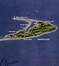 | Details | Macdonald, John Ross | 1958 |
| Birds Eye View of Cape Cod Nantucket Marthas Vineyard |
|
Macdonald, John Ross |
|
| 1958 |
| LOC:89 |
| $400.00 | Macdonald--John-Ross | Birds-Eye-View-of-Cape-Cod-Nantucket-Marthas-Vineyard | Original Map of Cape Cod and the Islands including Nantucket and Martha's Vineyard by John Ross McDonald, 1958. Apparently Macdonald, a local artist, published this map of Cape Cod himself after a painting he created. The map is notable for its photo-realistic appearance. Includes Nantucket Sound, The Atlantic Ocean, Vineyard Sound, Buzzard's Bay, and Cape Cod Bay. |
| 6649 |  | Details | Perkins, T.C. | 1905 |
| 1905 Connecticut Valley Electric Transit Route Pictorial |
|
Perkins, T.C. |
|
| 1905 |
| LOC:41 |
| $250.00 | Perkins--T-C- | 1905-Connecticut-Valley-Electric-Transit-Route-Pictorial | Birds'-eye view pictorial map of the Connecticut Valley, following the Connecticut River. Shows the Electric Transit Trolley Route from Hartford, Connecticut To Greenfield, Massachusetts. The route includes the towns of Hartford, Chicopee, Springfield, Holyoke, Greenfield, and Turner Falls with population centers shown pictorially in profile.
<br><br>
The Connecticut Valley Electric Transit Route was a trolley line that operated in the early 20th century, specifically from 1905 to 1926, in the Connecticut River Valley region of Massachusetts. The line was a part of the Springfield Street Railway Company, which was one of the largest electric streetcar systems in the United States at the time.
<br><br>
The Connecticut Valley Electric Transit Route ran from Springfield to Holyoke, Northampton, and Amherst, and it was an important transportation link for people living in those areas. The trolley line connected these towns and allowed for easy travel between them, which was especially important for college students attending schools in the region, such as Amherst College and Smith College.
<br><br>
Mount Tom is a mountain located in Holyoke, Massachusetts, in the Connecticut River Valley region. The mountain has an elevation of 1,202 feet (366 meters) and offers sweeping views of the surrounding area.
In the early 20th century, Mount Tom was a popular tourist destination, and it was a common stop on the Connecticut Valley Electric Transit Route. The trolley line had a station at the base of the mountain, and visitors could take a funicular railway up Mount Tom. Once at the top of Mount Tom, visitors could enjoy a range of activities, including hiking, picnicking, and even a zoo. The mountain was also home to a popular amusement park, which featured a roller coaster, a Ferris wheel, and other rides and attractions.
<br><br>Published by T.C. Perkins Hartford, Connecticut 1905. E.A. Sherman del. |
| 6520 |  | Details | MIT | 1946 |
| Campus map and handbook Massachusetts Institute of Technology |
|
MIT |
|
| 1946 |
| LOC:300 |
| $150.00 | MIT | Campus-map-and-handbook-Massachusetts-Institute-of-Technology | MIT campus map and handbook Massachusetts Institute of Technology. June, 1946. |
| 6519 |  | Details | Fuller and Whitney | 1885 |
| Charles River Basin and Harvard Bridge Economic Studies |
|
Fuller and Whitney |
|
| 1885 |
| LOC:300 |
| $1,900.00 | Fuller-and-Whitney | Charles-River-Basin-and-Harvard-Bridge-Economic-Studies | Manuscript surveyors-trace economic option studies for road approaches and the proposed West Chester Park Bridge (now, Harvard Bridge, MIT Bridge, or Massachusetts Avenue Bridge). Eight surveyors' trace documents to support civil engineering and economic options for the placement of the Harvard Bridge, spanning the Charles River between Boston and Cambridge, Massachusetts. General plans for the new bridge were approved in July 1887; the bridge opened in September 1891.
<br><br>
The lot consists of eight MS pen and ink traces (for blueprint production) consisting of two base maps of Boston and Cambridge as well as six MS trace sheets with street and bridge options. The two base maps show the Charles River Basin with the existing West Boston Bridge (Longfellow Bridge) and road network. One map has much greater detail on street names and improved larger lettering.
<br><br>
Six map overlays:<br>
<div class="indenttextblocksingle">
<ul style="list-style-type: circle;">
<li>No 1. Shows the proposed new route as well as text and tabular information for the gain or loss of time over the proposed new route.</li>
<li>No. 2 Shaded area shows lands of the Charles River Embankment Company (proposed Esplanade),
proposed approaches to the Charles River Esplanade and proposed West Chester Park Bridge (aka Harvard Bridge)</li>
<li>No. 3 Approaches for the proposed West Chester Park Bridge (east of the final location)</li>
<li>No. 4 Second option. Bridge located at West Chester (aka Massachusetts Avenue) but terminated slightly more to the east.</li>
<li>No. 5 Third option. Bridge at West Chester, and a proposed wide avenue extending to the end of Commonwealth in Cambridge.</li>
<li>No. 6 Fourth option. No Esplanade </li>
</ul>
</div>
Scale 1650 feet to one inch. |
| 6506 |  | Details | Dummer, H. Boylston | 1929 |
| Rare unrecorded pictorial historical map Boston South Shore |
|
Dummer, H. Boylston |
|
| 1929 |
| LOC: |
| $450.00 | Dummer--H--Boylston | Rare-unrecorded-pictorial-historical-map-Boston-South-Shore | Unrecorded and very scarce <strong>pictorial map of Boston's South Shore</strong> including the towns of Hingham and Cohasset. The map includes the locations of Bumkin Island, Weir River, World's End, Planters Hill, Sandy Beach, and Hominy Point. Inset illustrations of historical structures including the Garrison House, "Old Ship Church" and "The Old Ordinary" as well as named homes of local families including Ulman, Beal, Reilly, Donovan, Bolles, Foss and the entrance to the estate of Mrs. Thomas J. Plant and Mrs. E.R. Thayer's Weir River Farm.
<br><br>
No examples of the map in WorldCat, OWA, or AMPR. No other copies found online. An online search turned up another map by Dummer in a very similar style and format: "Points of Interest in Quaint Marblehead, published by the Marblehead Craft Shop.
<br></br>
Signed, and dated within to August 4, 1929, |
| 6466 |  | Details | Ambler, Edward Vassar | 1930 |
| Pictorial map of the Cape Ann Trail |
|
Ambler, Edward Vassar |
|
| 1930 |
| LOC:150 |
| $150.00 | Ambler--Edward-Vassar | Pictorial-map-of-the-Cape-Ann-Trail | Original 1930 pictorial map of the Cape Ann Trail, Massachusetts in a folding brochure (now flattened) published by the Gloucester, Massachusetts Chamber of Commerce. Attributed to Edward Vassar Ambler but the map is signed within the plate by "Mons". Copyright by Cottage Services, Inc. Text and cover on verso.
<br><br>
The map includes numerous pictograms highlighting key locations along the Cape Ann Trail. The border is filled with vignettes and text that provides detail about each feature. These features include:
<div class="indenttextblocksingle">
<ul style="list-style-type: circle;"></li>
<li>Norman's Woe</li>
<li>Five and Ten Pound Islands</li>
<li>Bass Rocks</li>
<li>Thatcher's Island</li>
<li>The Carillon Church</li>
<li>Ravenswood Park</li>
<li>Mother Ann</li>
<li>Rocky Neck</li>
</ul>
</div> |
| 6403 | 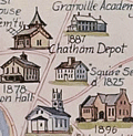 | Details | Rich, Howard L. | 1979 |
| Pictorial Historical Map of Chatham Massachusetts |
|
Rich, Howard L. |
|
| 1979 |
| LOC:87 |
| $225.00 | Rich--Howard-L- | Pictorial-Historical-Map-of-Chatham-Massachusetts | A fine original, first edition, pictorial historical map of Chatham, Massachusetts. Why buy a cheap copy when you can have the original version for a few dollars more?
<br></br>
The map shows numerous historical points of interest, those features no longer existing are shown in green font color. Includes an inset map of Monomoy Island and a smaller inset graphic representing the attack on Fort Fortune during October, 1606. Verso is blank.
<br></br>
Key geographical features on this historical map include Lookout Hill, Stage Harbor, Old Harbor, Great Beach, Strong Island, Great Hill, Morris Island, and Hardings Beach. Among the many historical events and locations that Rich chose to represent are the Mass. Humane Society hut for shipwrecked sailors, Old Harbor Life Saving Station, a ship's block factory, an Indian meeting house and burial ground, and the numerous salt works near Ryder's Cove.
<br></br>
Drawn by Howard L. Rich in 1979. Published by the Chatham Historical Society. |
| 6405 | 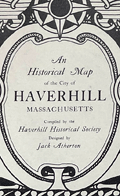 | Details | Atherton, Jack Bonney | 1940 |
| Rare Original Historical Map of Haverhill Massachusetts LeBaron-Bonney |
|
Atherton, Jack Bonney |
|
| 1940 |
| LOC:77 |
| $750.00 | Atherton--Jack-Bonney | Rare-Original-Historical-Map-of-Haverhill-Massachusetts-LeBaron-Bonney | Fine original antique pictorial map of Haverhill, Massachusetts dated within to 1940. Map was compiled by the Haverhill Historical Society, copyrighted and published by the LeBaron-Bonney Company of Bradford, Mass.
<br><br>
Apparently quite scarce. WorldCat shows only one institutional holding, at the Peabody Essex Museum.
<br><br>
Inset key to 38 historical locations identified numerically on the map. Some of those 39 locations with historical significance are depicted in inset graphic sketches including Buttonwoods, the old covered bridge, Kimball Tavern, the old Haverhill Academy, John Ward house, and the first post office.
<br><br>
This pictorial or picture map of Haverhill was designed by Jack Atherton and printed on paper with a light brown tint. Lee (LeBaron) Atherton and Jack (Bonney) Atherton opened the LeBaron-Bonney Co. as a bicycle rental business on Cape Cod in 1938, and expanded into a direct mail business offering pictorial and historic maps. |
| 6387 |  | Details | Parker, Larry | 1955 |
| Pictorial Map of Martha's Vineyard Island, Massachusetts |
|
Parker, Larry |
|
| 1955 |
| LOC:87 |
| $750.00 | Parker--Larry | Pictorial-Map-of-Martha-s-Vineyard-Island--Massachusetts | Original, scarce, 1950's Martha's Vineyard Island, Massachusetts pictorial map by Larry Parker. This lithographed tourist map features bright, bold colors, inset pictorial images of island life, and text blocks of historical facts, all hallmarks of a tourist souvenir map. Slight gloss to the paper finish as typical.
<br></br>
Remarkable condition.
<br></br>
This 1950's era edition is based on Parker's earlier 1935 black and white map of Martha's Vineyard Island. Not only does the new edition feature vivid lithographed color, several changes were made to the content including below the rope-wrapped bollard where the text "Edgartown Harbor" does not appear directly below the bollard. On this colored edition of Parker's map the area is blank. |
| 6337 | 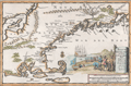 | Details | Aa, Pieter van der | 1707 |
| Nieuw Engeland in Twee Scheeptogten door Kapitein Johan Smith inde iaren 1614 en 1615 Bestevend |
|
Aa, Pieter van der |
|
| 1707 |
| LOC:78 |
| $1,000.00 | Aa--Pieter-van-der | Nieuw-Engeland-in-Twee-Scheeptogten-door-Kapitein-Johan-Smith-inde-iaren-1614-en-1615-Bestevend | Scarce map of New England, Cape Cod, Nantucket and more after John Smith. "Nieuw Engeland in Twee Scheeptogen door Kapitein Johan Smith inde iaren 1614 en 1615 bestevend". (New England as Described by Captain John Smith in two voyages in 1614 and 1615. By Pieter van der Aa, a Dutch mapmaker and publisher.
<br></br> |
| 5491 |  | Details | Eldredge, Everett R. | 1957 |
| Pickwick Ale Massachusetts Salt Water Guide Fishing Map |
|
Eldredge, Everett R. |
|
| 1957 |
| LOC:150 |
| $1,450.00 | Eldredge--Everett-R- | Pickwick-Ale-Massachusetts-Salt-Water-Guide-Fishing-Map | Very rare large original fishing map / advertising poster published and copyrighted by Haffenreffer Brewery, Boston, Massachusetts in 1957. No copies of this map are recorded anywhere online.
<br></br>
At bottom left, the map contains a photo and facsimile signature of Capt. Everett "Gunny" Eldredge holding a can of Pickwick Ale. Below the photo Eldredge is described as "Skipper of the Gannett II, Salt Water Sports Fishing Expert, Chatham, Mass."
<br></br>
Haffenreffer Brewery, established in 1870, was a former brewer in Jamaica Plain, Massachusetts. The Haffenreffer Brewery closed in 1965 and their brands, including Pickwick Ale, were sold to Narragansett Brewing Company.
<br</br>
Everett R. ‘Gunny’ Eldredge (1909 - 1999) was born in Boston and raised in Chatham, Mass. During World War II he served in the Merchant Marine. Eldredge was a licensed charter boat captain, a taxidermist, artist, and a respected naturalist and teacher. He was the builder, owner and director of a nature day camp for boys, and later of Camp Malabar Sea Camp for boys from 1936 to 1951. He built and owned Eldredge Marine Basin at Oyster River, now the Chatham Yacht Basin. Eldredge was the author of the Pickwick Ale Massachusetts's Sportsman's Guide. |
| 5402 |  | Details | Wadsworth, George | 1873 |
| Unrecorded First Map of the Town Of Everett Massachusetts |
|
Wadsworth, George |
|
| 1873 |
| LOC:53 |
| $4,500.00 | Wadsworth--George | Unrecorded-First-Map-of-the-Town-Of-Everett-Massachusetts | Unrecorded original lithographed map of Everett, in Middlesex County, Massachusetts published in October 1873, three years after the town of Everett separated from the city of Malden, Mass. on March 9, 1870. Originally part of Charlestown and later Malden, this is <strong>the first printed map solely of the town of Everett (1873)</strong> after the separation.
<br></br>
The cost of potable water was one of the key factors motivating the separation of Everett (South Malden) from Malden. In 1870 Everett was an agricultural community with a population of 2,152 inhabitants. The needs of what was then South Malden diverged from the northern part of Malden, particularly with respect to the need for a water source. Despite a near unanimous vote of South Malden, which could draw water from the Mystic River, Malden voted to source water from Spot Pond. Everett's charter in 1870 contained a clause that exempted the new town from the onerous debt Malden incurred in sourcing their water supply.
<br></br>
No holdings of this rare map are recorded anywhere online including the LOC and Leventhal Library.
<br></br>
Created by and based on the surveys of George Wadsworth, civil engineer and surveyor in Everett, and others.
Published and lithographed by J. Mayer and Co. 4 State Street, Boston. |
| 5370 | 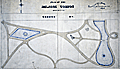 | Details | Stevens, Walter C. | 1892 |
| Manuscript presentation plan for Melrose Common in Melrose Massachusetts |
|
Stevens, Walter C. |
|
| 1892 |
| LOC: |
| $2,500.00 | Stevens--Walter-C- | Manuscript-presentation-plan-for-Melrose-Common-in-Melrose-Massachusetts | Unrecorded hand-colored manuscript presentation plan for the Melrose Common in Melrose, Massachusetts by Walter C. Stevens. 1892. Pen and ink plan of the Common surrounded by Second Street, Sixth Street, Third Street, and Larrabee Street. Scale 20 ft = 1 inch.
<br></br>
According to the History of Melrose, the Melrose Common was developed on land purchased and set aside by D.W. Gooch and Walter Littlefield in 1856 as part of a tract known as "The Home Association Lands." The land lay undeveloped for many years. As late as 1902 the Melrose Common was described:
<div class="indenttextblocksingle">
"... remains in a somewhat primeval state. Year by year, it is being utilized more and more as the place for the City's Fourth of July celebrations, display of fireworks, etc. It is hoped that some day the City will appropriate sufficient money to make of this a beautiful and healthful breathing spot and play ground." </div>
</br>
Two small lakes are shown on the plan. At left a lake contains a circular land area labeled "Maple Island". At right a large, bridged lake features a fountain.
<br></br>
By Walter C. Stevens, Civil Engineer and Surveyor from Melrose, Massachusetts. In 1894 Stevens was listed as "civil engineer for the town of Melrose."
<br></br>
Dated within to 1892. Red crayon surveyor's index collation number "2949". |
| 5365 | 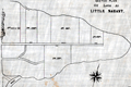 | Details | Anonymous | 1890 |
| Surveyors manuscript trace plat of Little Nahant Island, Massachusetts |
|
Anonymous |
|
| 1890 |
| LOC:13 |
| $750.00 | Anonymous | Surveyors-manuscript-trace-plat-of-Little-Nahant-Island--Massachusetts | Very rare unrecorded, manuscript surveyors' trace plat map of lots on Little Nahant Island, Massachusetts which lies north-east of Boston in Nahant Bay. The pen and ink trace, on supple surveyor's "tracing cloth" would have been used as a master to create blueprint copies.
<br></br>
Carries pencil surveyor's collation number 2013. Includes a fine late 19th century compass rose at bottom right. Estimated date ca. 1885.
<br></br>
Anonymous trace map but stylistically similar to those of W. H. Whitney from the 1890's. |
| 5352 | 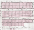 | Details | South Cove Corporation | 1845 |
| South Cove Boston Massachusetts Auction Plat Rare Antique Map |
|
South Cove Corporation |
|
| 1845 |
| LOC:90 |
| $550.00 | South-Cove-Corporation | South-Cove-Boston-Massachusetts-Auction-Plat-Rare-Antique-Map | Scarce lithographed cadastral map of land filled by the South Cove Corporation in Boston, Massachusetts to be sold at auction on February 18, 1845 by Francis Jackson, agent for the Corporation. Folded into a small 6" x 9" booklet [1] detailing the condition of the dividend (auction) and the dimensions of each lot to be sold.
<br></br>
The land to be sold by the South Cove Corporation was bounded by Albany Street, Harrison Avenue, Erie Street, and Troy Street and Cobb Wharf.
<br></br>
[1] "Catalogue of 132 lots of land in the South Cove with the numbers, dimensions, and contents affixed to each lot. To be divided among the stockholders, by order of the Directors of the South Cove Corporation." Press of Foster and Brewster. Boston. 1845. 8 pages. [Mass., landfill, made land] |
| 5321 | 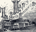 | Details | Price, R. M. | 1876 |
| Antique Map Of The South Mountain And Boston Rail Road and Connections |
|
Price, R. M. |
|
| 1876 |
| LOC:53 |
| $350.00 | Price--R--M- | Antique-Map-Of-The-South-Mountain-And-Boston-Rail-Road-and-Connections | Hand-colored, antique lithographed thematic map showing the route of the South Mountain and Boston Rail Road across the states of New York, New Jersey, Pennsylvania, and Massachusetts. Colored regions of the map are labeled with names of the metals, fossil fuels or other natural resources in the vicinity of the SM&BRR route. These resources include:
<div class="indenttextblocksingle">
<ul style="list-style-type: circle;">
<li>Coal</li>
<li>Bituminous Coal</li>
<li>Anthracite</li>
<li>Iron</li>
<li>Zinc</li>
<li>Petroleum</li>
<li>Lumber</li>
</ul>
</div>
Incorporated in 1854, the company suffered during the Panic of 1873 and began to auction off its property between 1877 and 1880. Includes a fine large decorative title vignette showing a puffing SM&BRR locomotive pulling passenger cars out of a dark tunnel.
<br></br>
The map was produced by R.M. Price Jr, Chief Engineer for the railroad. Published by Reading Publishing House in 1876.
<br></br>
Title: "Map Of The South Mountain And Boston Rail Road & Connections showing territory passed through rail-roads and canals crossed or connected with together with mineral and geographical features of country passed through."
<br></br>
Inset map of the SM&BRR bridge over the Hudson River: "Bridge by which the South Mountain & Boston R.R. is to cross the Hudson River at Poughkeepsie, N.Y. A short, direct railroad route from New England to the coal, oil, and slate regions of Pennsylvania and to the west and south."
<br></br>
Verso includes two Pennsylvanian township maps- Washington and Heidelburg townships. Neat pencil notation on verso: John Strauss, Mrs. Strauss |
| 5284 | ![Manuscript trace of the earliest map of Erving's Grant, 1788 [1910].](../../ZoomifyImages/SC_5284/TN.GIF?v=2) | Details | Avery, F. Deane | 1910 |
| Manuscript trace Erving's Grant Massachusetts Map by Metcalf |
|
Avery, F. Deane |
|
| 1910 |
| LOC:10 |
| $1,100.00 | Avery--F--Deane | Manuscript-trace-Erving-s-Grant-Massachusetts-Map-by-Metcalf | Rare decorative ink manuscript trace map ca. 1910 made by F. Deane Avery (1876 - 1940) of an earlier 1788 [1] map of Erving's Grant, Massachusetts by surveyor Joseph Metcalf in Orange, MA. April 21, 1788 (copied by John ? Pope, Boston, August 11, 1788). The text describing Metcalf's map is in a decorative calligraphic style as might have been used in the late 18th century. The only available true copy of Metcalf's survey of Erving's Grant. [2]
<br></br>
In 1920 Avery, self-described as an "Engineer and Architect", published a short article describing his method of indexing survey artifacts [3]. By 1924 F. Deane Avery was employed as County Engineer in Greenfield, Massachusetts. With Avery's index number "5B-20" at lower right corner.
<br></br>
[1] On February 6, 1788 Massachusetts became the sixth state to ratify the U.S. Constitution and was admitted to the Union.<br>
[2] On the map the land is described as lying in Hampshire County, but today the land lies in Franklin County, Massachusetts.<br>
[3] Avery, F. Deane. "A simple system of indexing notes and plans: Filing by location preferred to other methods- key has numbered areas- loose leaf ledger used". Engineering News-Record. Vol. 85 p. 155. |
| 5270 | 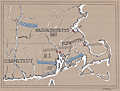 | Details | Griffin, J. Eve | 1997 |
| Manuscript map of tribes Massachusetts, Rhode Island |
|
Griffin, J. Eve |
|
| 1997 |
| LOC:10 |
| $280.00 | Griffin--J--Eve | Manuscript-map-of-tribes-Massachusetts--Rhode-Island | Manuscript map, artwork for the book "Two Paths in the Wilderness" by Ellen Eaton Wilson, published in 1997. The book, about King Philip's War, included the Wampanoag Indians of Rhode Island and the first organized resistance of American Indians to English intrusion on their homelands. This map is the first of two similar MS maps in our inventory by Griffin.
<br></br>
The map, drawn by J. Eve Griffin, is reproduced in the book. Map includes the states of Connecticut, Massachusetts, and Rhode Island with the locations shown for native American Indian tribes: Nipmucks, Narragansett, and Wampanoags. |
| 5271 | 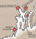 | Details | Griffin, J. Eve | 1997 |
| Manuscript map of Connecticut Massachusetts Rhode Island |
|
Griffin, J. Eve |
|
| 1997 |
| LOC:10 |
| $280.00 | Griffin--J--Eve | Manuscript-map-of-Connecticut-Massachusetts-Rhode-Island | Manuscript map, artwork for the book "Two Paths in the Wilderness" by Ellen Eaton Wilson, published in 1997. The book, about King Philip's War, included the Wampanoag Indians of Rhode Island and the first organized resistance of American Indians to English intrusion on their homelands. This map is the second of two similar MS maps in our inventory by Griffin.
<br></br>
The map, drawn by J. Eve Griffin, is reproduced in the book. Map includes the states of Connecticut, Massachusetts, and Rhode Island with several of the small towns identified including Deerfield, Hadley, Marlboro, Mt. Hope, and Simsbury. |
| 5174 |  | Details | Hettinger, C. F. | 1901 |
| Cyanotype blueprint floor plan for 1901 Boston Brew-master's convention |
|
Hettinger, C. F. |
|
| 1901 |
| LOC:62 |
| $550.00 | Hettinger--C--F- | Cyanotype-blueprint-floor-plan-for-1901-Boston-Brew-master-s-convention | Original one-of-a-kind cyanotype, or blueprint, floor plan for the 1901 Brew-Master's Convention to be held in the Massachusetts Charitable Mechanic Association Building, Boston Mass. The 13th annual convention of the <b>United States Brewmaster's Association</b> was held in Boston during the week beginning on September 23, 1901.
<br></br>
The plan distinguishes between two areas in the building- the Convention Hall and the Exhibition Hall. The Exhibition Hall was a new feature of the convention:
<div class="indenttextblocksingle">
"… it has been thought desirable to make special arrangements for facilities for demonstrating and exhibiting all classes of machines and supplies adapted to brewer's use …" [1]
</div>
</br>
The Charitable Mechanics Association built the Mechanic's Hall in 1881 on Huntington Avenue, at West Newton Street near Copley Square. Architect William Gibbons Preston designed the hall which featured an auditorium, sometimes referred to as the Grand Hall. The hall was demolished in 1958.
<br></br>
Drawn and printed by C. F. Hettinger & Co. Engineers & Architects. 1140 Columbus Ave. Boston, Mass.
<br></br>
[1] Online: Gindele, William J. American Brewers' Review. Wahl and Henius eds. 1900-1901. p.282.
<br></br>
(beer, brewing, brew, craft beer, brewery, hops, tipsy, hopped up, loaded, drunk, shit-faced, sdfngd) |
| 5138 | 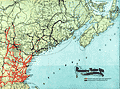 | Details | Boston and Maine Railroad | 1901 |
| Map of railway lines for the Boston and Maine Railroad |
|
Boston and Maine Railroad |
|
| 1901 |
| LOC:10 |
| $150.00 | Boston-and-Maine-Railroad | Map-of-railway-lines-for-the-Boston-and-Maine-Railroad | Official corporate map of railway and steamship lines for the Boston and Maine Railroad. Lithograph on thin paper.
<br></br>
Printed and included in the "Sixty-eighth Annual Report of the Directors of the Boston and Maine Railway to the Stockholders for the Year Ended June 30, 1901." Printed at Boston, Massachusetts in 1901 by Rand Avery Supply Company.
<br></br>
Red lines designate Boston & Maine lines and leased lines operated by the railroad. Purple lines show lines controlled by the Boston and Maine R.R. Includes steamship routes owned and operated by the company shown offshore with black or purple dotted lines. Margins about 1/4" on all sides. |
| 4941 | 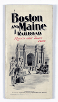 | Details | Boston and Maine Railroad | 1903 |
| Boston and Maine Railroad Summer Excursions with five maps |
|
Boston and Maine Railroad |
|
| 1903 |
| LOC:2001 |
| $350.00 | Boston-and-Maine-Railroad | Boston-and-Maine-Railroad-Summer-Excursions-with-five-maps | Rare booklet from the Boston and Maine Railroad (1903) with Summer Excursions, rates, stage and steamer connections. Includes five maps and birds-eye views on thin paper. 88 pages. Thin card covers. 4" x 8" overall.<br></br>
"Boston and Maine Railroad Summer Excursions to the White Mountains, Mount Desert, Adirondacks, Catskills, Montreal and Quebec, Winnipesaukee, Memphremagog, Champlain, Rangeley and Moosehead lakes and the New England Beaches."
<div class="indenttextblocksingle">
<ul style="list-style-type: circle;">
<li>1) "Bird's Eye Map of the White Mountains reached by Boston and Maine." Birds-eye view map of the White Mountains in New Hampshire. </li>
<li>2) Map of Lake Winnipesaukee and Vicinity Reached by Boston and Maine and Steamer Mt. Washington. Printed by Rand, Avery Supply Co,. Engineers and Printers, Boston.<.li>
<li>3) Lake Memphremagog and About There. Boston and Maine Railroad. Printed by Rand Avery Supply Company, Boston, Mass.</li>
<li>4) Fishing and Hunting Resorts reached by Boston and Maine Railroad Connections.</li>
<li>5) Map of Lake Sunapee and Vicinity Reached by Boston and Maine Railroad. Rand, Avery Supply Co,. Engineers, Boston, Mass.</li>
</ul>
</div>
Issued by the Passenger Department, Boston and Maine Railroad. 1903. Boston City Ticket Office: 322 Washington Street Cor. Of Milk Street |
| 4913 | 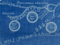 | Details | New York, Providence and Boston Railroad | 1892 |
| Antique Chart New York, Providence and Boston Railroad |
|
New York, Providence and Boston Railroad |
|
| 1892 |
| LOC:62 |
| $550.00 | New-York--Providence-and-Boston-Railroad | Antique-Chart-New-York--Providence-and-Boston-Railroad | A foundational organizational diagram / map for collectors of ephemera related to the New York, Providence and Boston Railroad.
<br /><br/>
Very rare and very unusual cyanotype (blueprint) document showing the railroad and steamship lines, as of 1892, that comprised the New York, Providence and Boston Railroad (N.Y.P. & B.R.R.). Includes unusually-presented notes about dates of construction and leasing of the various component lines of the railroad within circular icons.
<br /><br />
A fine example of the use of the cyanotype process to create a map not intended for navigation but rather to inform the reader about the history of the railroad and its affiliated Providence and Stonington Steamship Company.
<br /><br />
Produced from Providence, Rhode Island by the Chief Engineer's Office in March, 1892. |
| 4874 | 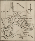 | Details | Whitman and Breck | 1885 |
| Plan Sea Shore Lots Revere Beach Land Company Revere Massachusetts |
|
Whitman and Breck |
|
| 1885 |
| LOC:53 |
| $2,400.00 | Whitman-and-Breck | Plan-Sea-Shore-Lots-Revere-Beach-Land-Company-Revere-Massachusetts | Unrecorded heliotype plan or plat of lots for sale in today's Beachmont neighborhood with Crescent Beach and Revere Beach. Published in 1885 by the Revere Beach Land Company in Revere, Massachusetts. Large inset with a large-scale map of Winthrop Highlands, Revere, Beachmont and Crescent Beach
<br></br>
Surveyed by Whitman and Breck, 35 Devonshire St. Street, Boston.
<br></br>
Heliotype printed. A heliotype is a print produced by a “photomechanically produced plate for pictures or type made by exposing a gelatin film under a negative, hardening it with chrome alum, and printing directly from it.” (Source: https://www.thefreedictionary.com/heliotype) |
| 4808 |  | Details | George W. Walker Lithograph and Publishing Co | 1925 |
| Attractive lithographed map of Boston, Mass |
|
George W. Walker Lithograph and Publishing Co |
|
| 1925 |
| LOC:53 |
| $180.00 | George-W--Walker-Lithograph-and-Publishing-Co | Attractive-lithographed-map-of-Boston--Mass | Fine lithographed map of Boston, Massachusetts by Walker Lithographers and Publishers, 400 Newbury Street, Boston. In a style easily recognizable as Walker's. Attractive appearance with variously-shaped red and green lines identifying surface lines, subway lines, elevated lines, and tunnels , all explained in a key at the bottom right corner. Parks and common lands are identified with solid green.
<br></br>
Shows the beginnings of a municipal airport ("airplane landing field") on the East Boston Flats where Logan's Field now stands. Map contains two helpful lists: "places of amusement" and "places of historical and general interest." Includes numerous piers and docks along with significant portions of South Bay, the Charles River, the Mystic River and Chelsea River.
<br></br>
Folding pocket map folds to a simple brown card-stock cover 3" x 5". Cover states this as "Walker's Vest Pocket Map of Boston" with an address as 390 Newbury Street, different from the address on the map at 400 Newbury Street.
<br></br>
Undated but based on known dates for the airport construction and some of the subway stations, the estimated publishing date for this piece is ca. 1925. |
| 4771 | 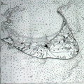 | Details | U.S. Coast and Geodetic Survey | 1916 |
| Nantucket Sound Massachusetts |
|
U.S. Coast and Geodetic Survey |
|
| 1916 |
| LOC:53 |
| $1,200.00 | U-S--Coast-and-Geodetic-Survey | Nantucket-Sound-Massachusetts | Fine antique engraved nautical chart first issued in 1915 covers the southeast portion of Cape Cod trending south and includes Hyannis Harbor, Tuckernuck Island and the islands of Nantucket, Monomoy, Chatham and eastern Nantucket Sound.
<br></br>
This bright antique chart bears a stamp at the bottom right in black ink that identifies this edition as corrected to May 29, 1916. Plate number 3446 for this 1915 ed. replaced the previous edition of 1909 which used plate number 2999. With the circular logo of the Department of Commerce and Labor. Chart number 111. |
| 4759 |  | Details | Baker, Edmund J. | 1831 |
| Very Rare Map of Dorchester and Milton Massachusetts |
|
Baker, Edmund J. |
|
| 1831 |
| LOC:53 |
| $4,500.00 | Baker--Edmund-J- | Very-Rare-Map-of-Dorchester-and-Milton-Massachusetts | Very rare map of Dorchester and Milton Massachusetts published by Edmund J. Baker of Milton, Mass. Very fine condition for such a scarce item.
<br></br>
This original antique map was compiled to comply with a resolution of the Massachusetts Commonwealth that every town and district in Boston should complete an accurate survey of 100 rods to an inch before July 1, 1831. The resolution specified the map record
<div class="indenttextblock">
"...the names, courses, and magnitude of Rivers and smaller Streams; Roads, public and private with their courses; the situation of Houses of Public Worship, Court Houses, and other public buildings, … bridges; ferries; falls; ponds; shores; harbors; islands; mountains; mills and manufactories… shall be inserted, specified, delineated, or described."
</div>
</BR>
According to the Milton Historical Society
<div class="indenttextblock">
"Born in 1804, Baker was a postmaster and historian accorded great respect by his contemporaries. Grandson of both patriot Daniel Vose and chocolate pioneer Dr. James Baker, he had a direct connection to the town's most auspicious 18th century roots. His interest and conversations with that generation, such as Rachel Vose, make him an important source
</div> |
| 4736 |  | Details | Murphy, John F. | 1915 |
| Birds Eye View of Boston Harbor and South Shore to Provincetown |
|
Murphy, John F. |
|
| 1915 |
| LOC:88 |
| $275.00 | Murphy--John-F- | Birds-Eye-View-of-Boston-Harbor-and-South-Shore-to-Provincetown | ON HOLD
<br><br>A fine, original, early 20th-century folding harbor excursion map of Boston Harbor ready for framing. This fine antique birds-eye view is bright, in great condition with no holes or tears as is common.
<BR> </BR>
Coverage includes South Boston, Nantasket Beach, Hough's Neck, South Bay, Pleasure Bay, Boston Harbor, Dorchester Bay, Quincy Bay, Hingham, Squantum, and Cape Cod Bay to Provincetown. Verso is blank. Index on inside cover with 35 points of interest keyed on the map.
<BR> </BR>
Published by Union News Company , South Station, Boston, Massachusetts. Price is noted on the front cover as "10 cents". Manuscript owner's name on cover, detached but present. |
| 4718 | 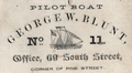 | Details | Blunt, George W. | 1860 |
| Rare trade card- NY Pilot Boat 11 the George W. Blunt |
|
Blunt, George W. |
|
| 1860 |
| LOC:41 |
| $500.00 | Blunt--George-W- | Rare-trade-card--NY-Pilot-Boat-11-the-George-W--Blunt | Very rare and desirable antebellum trade card for Pilot Boat No. 11, the George W. Blunt (G.W. Blunt) of the New York harbor pilots. Named after one of three sons of Edmund Blunt, who was one of the most important figures in U.S. nautical cartography during the first half of the 19th century. This scarce Civil-war era artifact should have strong interest for collectors of 19th-century maritime nautical cartography, the history of New York harbor, or civil-war era nautical artifacts.
<br></br>
The George W. Blunt was a 76 ton wooden schooner for the New York Pilot Commission, acquired by the U.S. Navy and commissioned in December 1861. She served with the South Atlantic Blockading Squadron through mid 1864. This trade card dates to before 1861 when the Pilot Commissioners' office was located at 69 South Street, Corner of Pine Street. In 1875 the G. W. Blunt was lost on the Long Island shore about thirty miles from the Sandy Hook light vessel (1).
<br></br>
G. W. Blunt, the third son of Edmund M. Blunt was born in Newburyport, Mass in 1802 (2). The elder Blunt prepared and composed a work entitled "The American Coast Pilot" which described every port on the coast of the United States, the publication went through 18 successive editions beginning in 1796.
<br></br>
George W. Blunt served as a member of the New York Board of Pilot Commissioners, from 1845 to 1877. and owned the New York pilot boat Moses H. Grinnell (3). At his death G.W. Blunt held the office of Secretary of the Board of Pilot Commissioners.
<br></br> <i>
(1) Pilot lore; from sail to steam. United New York and New Jersey. Sandy Hook Pilots Benevolent Associations. 1922. Online.
</BR>
(2) http://nyscu.org/Archives/
</BR>
(3) Cunliffe, Tom. ed. Pilots: Pilot Schooners of North America and Great Britain. Wooden Boat Publications. Brooklin, Maine. 2001.
</i> |
| 3629 |  | Details | Nickerson, K.F. | 1955 |
| Manuscript chart of Cape Cod, Massachusetts Bay, Provincetown |
|
Nickerson, K.F. |
|
| 1955 |
| LOC:200 |
| $450.00 | Nickerson--K-F- | Manuscript-chart-of-Cape-Cod--Massachusetts-Bay--Provincetown | An interesting manuscript chart of Cape Cod and Cape Cod Bay in black and red ink. Not only does the chart have a different look than a printed chart but the item raises questions as to why so much care was placed on its creation. Signed by K.F. Nickerson and dated to February 1955.
<br></br>
Detailed mid 20th-century manuscript chart of Cape Cod, Massachusetts Bay and Cape Cod Bay. The MS chart is drawn on the verso of an earlier chart from 1935. Nickerson apparently cannibalized an old chart simply to create his chart on the back. We don't know why Nickerson spent so much time on the chart but it is evident he spent hours meticulously copying from an unknown source. Perhaps the map was constructed for sale as a tourist keepsake. More likely it had some utility to Nickerson in his occupation, because the chart detail is at a granular level that could be used for navigation.
<br></br>
Contains info on radio beacons, depth soundings, maritime hazards, aids to navigation and much more. Scale 1/2 inch = 1 mile. |
| 3613 |  | Details | Multiple Authors | 1885 |
| Lot 2. MULTIPLE antique surveyors plans BACK BAY, BOSTON , Massachusetts |
|
Multiple Authors |
|
| 1885 |
| LOC:0 |
| $6,200.00 | Multiple-Authors | Lot-2---MULTIPLE-antique-surveyors-plans-BACK-BAY--BOSTON---Massachusetts | A lot consisting of twenty lot and street plans from Boston, Massachusetts generally from the decade of the 1880's. Most items by surveyors and engineers William H. Whitney or the firm of Fuller and Whitney, Back Bay Engineers. An opportunity for a serious collector of Boston cartography to expand his collection with items he cannot find except in institutions. <a href="https://www.rarecharts.com/Content/Lot_2_Boston_Survey_Artifacts_Locked.pdf" target="_blank">See full detailed lot description.</a>
<br></br>
From the mid 1850’s through 1890 Boston conducted the most ambitious land-making of the era in the U.S. by transporting and placing gravel, ashes, and sand in an area that was previously a tidal marsh of the Charles River. The landfill of Boston’s Back Bay was fueled by a shortage of suitable land for new construction and the desire to remediate water pollution resulting from earlier bad decisions that placed profit ahead of citizen’s health and welfare.
<br></br>
Over a period of 35 years more than 450 acres of new land was added to Boston by filling the Back Bay with an average of 20 feet of fill. Much of this land was purchased by well-to-do Bostonians and today the Back Bay remains one of the most prestigious locations within that city.
<br></br>
We have been able to obtain 20 rare late 19th century artifacts that document the last decade of the 35 year land-making project in Boston’s Back Bay, for an area from Charlesgate Park to past Kenmore Square.
<br></br>
These maps and plans shed light on some of the decision-making factors and design options for Boston real-estate developers. These artifacts in this lot are of three types: hand-drawn or manuscript survey maps, manuscript traces of those surveys, and blueprints. The artifacts represent a very early application and adaptation of a cutting-edge technology: blueprinting. |
| 3605 |  | Details | Eldridge, George | 1872 |
| Early Eldridge Harbor Chart of Salem, Beverly, Marblehead, Manchester, Gloucester, Rockport |
|
Eldridge, George |
|
| 1872 |
| LOC:53 |
| $650.00 | Eldridge--George | Early-Eldridge-Harbor-Chart-of-Salem--Beverly--Marblehead--Manchester--Gloucester--Rockport | Scarce and early Eldridge coastal chart of Massachusetts from LYNN to HALIBUT POINT. Shows George Eldridge's (the founder) bold and distinctive style that mariners came to appreciate for its utility.
<br></br>
Includes the towns of Lynn, Swampscott, Salem, Beverly, Marblehead, Manchester, Gloucester, Cape Ann, Rockport, and Annisquam. Includes extensive sailing directions.
<br></br>
Dated within to 1872. Published by S. Thaxter & Son, 125 State Street, Boston.
<br></br>
George Eldridge (1821-1900) was a fisherman, coastal pilot, and cartographer who published charts and coast pilots, some with his son George W., from the mid 1800's until his death . The Eldridges published their own charts in competition with the U.S. Coast Survey. |
| 3597 |  | Details | Multiple Authors | 1870 |
| Lot 1. MULTIPLE 19th C. survey lot and street plans CAMBRIDGE, Massachusetts |
|
Multiple Authors |
|
| 1870 |
| LOC:0 |
| $14,650.00 | Multiple-Authors | Lot-1---MULTIPLE-19th-C--survey-lot-and-street-plans-CAMBRIDGE--Massachusetts | A lot consisting of twenty-five lot and street plans from Cambridge, Massachusetts and nearby areas. An opportunity for a serious collector to expand his collection with items he cannot find elsewhere. <a href="https://www.rarecharts.com/Content/Lot_1_Cambridge_Survey_Artifacts_Locked.pdf" target="_blank">See full detailed lot description.</a>
<br></br>
These plans represent surveys performed in the 1840’s through the 1900’s by local Cambridge area surveyors and engineers William A. Mason, Joseph Whitney, J.G. Chase, E.F. Bowker, W.S. Barbour, and Alex Wadsworth. Artifacts include manuscript surveys, manuscript survey traces, and rare 19th century cyanotype (blueprints). Many of the items in this lot are unrecorded and for the others the few known holdings are in institutions. Condition and size vary by item.
<br></br>
The lot highlight is:
SC_Cam_1. Osgood Carleton [after]. PLAN OF THE CAUSEWAY OVER THE MARSH IN CAMBRIDGE EXHIBITING THE NAMES OF THE OWNERS AND THE QUANTITY OF LAND THROUGH WHICH IT PASSES INCLUDING MR JARVIS’S UPLAND SURVEYED AND PLATTED (by a scale of one chain to an inch) NOV 12TH 1792 BY OSGOOD CARLETON. COPIED FROM THE ORIGINAL BY W.A. MASON & CO. DEC. 20, 1855. MS ink surveyor’s collation number “1637”.
Unrecorded antebellum manuscript cadastral plan of great historical value after an earlier plan in 1793 by well-known Boston surveyor Osgood Carleton. This is the best and only available detailed plan of the West Boston Bridge causeway from the Charles River to Pelham island. This is Mason’s true signed MS surveyor’s copy from a survey made by Osgood Carleton contemporaneously with the Causeway construction. Numerous and detailed pencil notations of ownership record based on Carleton's original survey. Measurements recorded in chains and links.
<br></br>
A very rare plan of the old Causeway stretching 3344 feet over wet marshland largely owned by Leonard Jarvis. |
| 3588 |  | Details | Eldridge, George W. | 1914 |
| Iconic Antique Chart of Provincetown, Mass. |
|
Eldridge, George W. |
|
| 1914 |
| LOC:10 |
| $450.00 | Eldridge--George-W- | Iconic-Antique-Chart-of-Provincetown--Mass- | Elegant, simple and useful early 20th-century antique nautical chart of Provincetown, Massachusetts on the island of Cape Cod, Mass. Very attractive hand coloring. Features include Race Point, Wood End Bar, North Truro, Clapp's Pond, Herring Cove, Shank Painter Pond; and the Highland, Crow Hill, and Peaked Hill Life Saving Stations.
<br></br>
Much useful information including soundings, anchorages, ranges, buoys, and bottom composition are presented by Eldridge in a clear graphic style that would have been appreciated by and helpful to mariners. For instance, this chart of Provincetown, MA. is printed with bold black coastal outlines that would have been much easier to read under poor lighting conditions. Lighthouses, buoys, and other aids to navigation are highlighted in red. Bottom composition is presented according to an attached table of abbreviations.
<br></br>
Published by Wilfrid O. White of Boston, Massachusetts. White was G. W. Eldridge's son-in-law who continued to sell Eldridge's charts after his death until 1932.
<br></br>
Attribution reads: 'AUTHORIZED and PUBLISHED By Geo. W. Eldridge, Kelvin & Wilfrid O. White Co. 112 State Street, Boston. 38 Water Street, New York ' Number 49 in Eldridge's book of harbor charts. |
| 2553 | 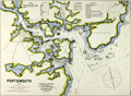 | Details | Eldridge, George W. | 1908 |
| Antique Chart of Portsmouth, New Hampshire |
|
Eldridge, George W. |
|
| 1908 |
| LOC:10 |
| $145.00 | Eldridge--George-W- | Antique-Chart-of-Portsmouth--New-Hampshire | Elegant, simple and useful early 20th-century antique nautical chart of Portsmouth, New Hampshire harbor and entrance. Nearby points of interest include Kittery, Seaveys Island, Gerrishes Island, Cutts Island, Newcastle Island, Little Harbor, Sagamore Creek and much more. By George W. Eldridge.
<br></br>
Much useful information including soundings, anchorages, ranges, buoys, and bottom composition are presented by Eldridge in a clear graphic style that would have been appreciated by and helpful to mariners. For instance, these charts are printed with bold black coastal outlines that would have been much easier to read under poor lighting conditions.
<br></br>
Attribution reads: 'AUTHORIZED and PUBLISHED By Geo. W. Eldridge, Vineyard Haven, Mass and 132 State St. Boston.' Number 56 from Eldridges book of harbor charts. Price 30 cents. |
| 2540 | 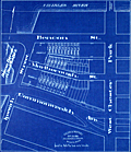 | Details | Fuller and Whitney | 1885 |
| Antique blueprint engineer's plan of Boston's Charlesgate East area |
|
Fuller and Whitney |
|
| 1885 |
| LOC:86 |
| $375.00 | Fuller-and-Whitney | Antique-blueprint-engineer-s-plan-of-Boston-s-Charlesgate-East-area | Original rare cadastral blueprint plan from September 22, 1885 providing detail for a portion of Boston's Back Bay on Beacon Street, Marlborough Street, and Commonwealth Avenue west of West Chester Park (Massachusetts Avenue) and east of Ipswich Street (Charlesgate East). At center left the reader will find the Beacon Entrance to Back Bay Park.
<br></br>
This blueprint, and perhaps other like it, were the end product created from <a href="https://www.rarecharts.com/ShowDetail/Creator/Fuller-and-Whitney/Title/Antique-manuscript-engineers-traced-plan-of-Boston-s-Charlesgate-East-area/2543" target="_blank">a manuscript trace document</a> by William H. Whitney.
</div>
Verso is blank.
<br></br>
During the period 1872 to 1888 Fuller & Whitney Civil Engineers, was conducted as a partnership between J. Franklin Fuller and William H. Whitney with offices at 39 Court Street, Boston, Mass. Whitney assumed sole control of the firm in 1888 and changed the name to William H. Whitney.
<br></br>
In his autobiography Whitney refers to his work with the latest cutting-edge reprographic technology- blueprinting: <div class="indenttextblock">“In September 1881 I received a bronze medal at the Massachusetts Charitable Mechanic Association Exhibit for sun or blue prints. I developed a process from the French and used it in illustrating the growth of Back Bay lands. I issued to subscribers monthly schedules and maps showing the changes of ownership, increase in value, improvement by filling and public works.” (The New England Historical and Genealogical Register. Vol 64, January 1910. Number 253. p. lix).</div> |
| 2541 | 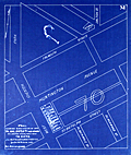 | Details | Fuller and Whitney | 1886 |
| Antique blueprint plan of Boston near Huntington and Massachusetts Avenues |
|
Fuller and Whitney |
|
| 1886 |
| LOC: |
| $300.00 | Fuller-and-Whitney | Antique-blueprint-plan-of-Boston-near-Huntington-and-Massachusetts-Avenues | Original cadastral blueprint plan from Jan. 1, 1886 of a portion of the Boston' Back Bay east of Massachusetts Avenue. The area includes the current location of the Boston Philharmonic Orchestra at 236 Huntington Ave. In the upper portion of the plan an artifact of the blueprint process reveals where a piece of lint or vegetation landed between the surveyor's trace and blueprint paper during exposure of the paper to sunlight.
<br></br>
The area for this blueprint in Boston, Massachusetts is bounded on three sides by Falmouth Street, West Chester Park (now Massachusetts Avenue) and St. Botolph Street. Verso is blank. Sheet is labeled "M". |
| 2543 | 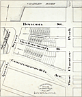 | Details | Fuller and Whitney | 1885 |
| Antique manuscript engineers traced plan of Boston's Charlesgate East area |
|
Fuller and Whitney |
|
| 1885 |
| LOC:86 |
| $500.00 | Fuller-and-Whitney | Antique-manuscript-engineers-traced-plan-of-Boston-s-Charlesgate-East-area | William H. Whitney was a very early adopter of the "blue process" or blueprinting . Both this trace and the <a href="https://www.rarecharts.com/ShowDetail/Creator/Fuller-and-Whitney/Title/Antique-blueprint-engineer-s-plan-of-Boston-s-Charlesgate-East-area/2540" target="_blank">blueprint produced from this trace</a> were created by Whitney just 4 years after the earliest recorded use of blueprints for his Boston-based civil engineering firm.
<br><br>
This rare artifact is the original manuscript cadastral ink trace on tracing cloth from September 22, 1885 providing plan detail for a portion of the Boston Back Bay on Beacon and Marlborough Streets and Commonwealth Avenue west of West Chester Park (Massachusetts Avenue) and east of Ipswich Street (Charlesgate East). This trace would have been used as the reproducible master source to create one or more blueprints, then a new reprographic technology.
<br><br>
With Fuller & Whitney's ink oval over stamp. MS number in pencil at bottom right: "1277".
<br></br>
</div> |
| 2525 | 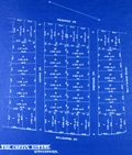 | Details | Bowker, E.F. | 1899 |
| Antique blueprint plan of the Coffin Estate, Watertown, Mass |
|
Bowker, E.F. |
|
| 1899 |
| LOC:0 |
| $475.00 | Bowker--E-F- | Antique-blueprint-plan-of-the-Coffin-Estate--Watertown--Mass | Rare late 19th-century blueprint of house lots for sale just northwest of Mt. Auburn Cemetery. A fine antique plat of the Coffin Estate in Watertown Massachusetts. Previously unrecorded plat with no copies found anywhere. The area covered in this blueprint is bounded by Arlington Street and Prentiss Street at cross streets of Dewey St., Sampson Street, and Keenan St., now E-W rather than N-S as shown. Data included for each lot includes lot dimensions, total square feet, and lot number.
<br></br>
19th century blueprints are generally scarce as blueprinting had only been invented in the 1870's and by 1899 was beginning to become widely adopted as a quick method of reproducing maps, plans, and architectural diagrams.
<br></br>
By E.F. Bowker, Engineer and Surveyor, 671 Massachusetts Ave. Cambridgeport, Mass. MS surveyor's number "1809" in corners. Dated within at January 9, 1899. |
| 2527 | 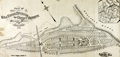 | Details | Whitman and Breck | 1874 |
| Plan of land in Orient Heights - Beachmont in Revere, Mass. |
|
Whitman and Breck |
|
| 1874 |
| LOC:53 |
| $2,400.00 | Whitman-and-Breck | Plan-of-land-in-Orient-Heights---Beachmont-in-Revere---Mass- | Unrecorded heliotype plan or plat of land for sale in 1874 by the Boston Land Company in Orient Heights, Revere, Massachusetts- today's Beachmont neighborhood. Orient Heights is Boston's northernmost and northeastern most neighborhood.
<br></br>
This early antique lot plan of Beachmont, is an unrecorded plan found nowhere else online. Bordered at the east by the Atlantic Ocean, the platted land lies with an area bounded by Endicott Avenue and Winthrop Avenue. Includes Bradstreet Avenue, Dudley Street, Sales Street, Cross Street, Crest Avenue, Bellingham Avenue and Leverett Avenue.
<br></br>
Other notable features include a proposed Boston Revere Beach and Lynn Railroad track and depot; the Orient Café surrounded by a small park; Sales Creek and a sand ridge. For each lot square footage and lot number are shown.
<br></br>
In upper right an inset small-scale map of other holdings of the Boston Land Company in Revere, Mass. with major roads, waterways and rail lines.
<br></br>
Surveyed by Whitman and Breck, 16 Water Street, Boston. Heliotype printed. A heliotype is a print produced by a “photomechanically produced plate for pictures or type made by exposing a gelatin film under a negative, hardening it with chrome alum, and printing directly from it.” (Source: https://www.thefreedictionary.com/heliotype) |
| 5369 |  | Details | Whitman and Breck | 1880 |
| Plan of Section A in Orient Heights - Boston, Mass. |
|
Whitman and Breck |
|
| 1880 |
| LOC:53 |
| $2,400.00 | Whitman-and-Breck | Plan-of-Section-A-in-Orient-Heights---Boston---Mass- | Unrecorded plat of lands, ca. 1880, belonging to the Boston Land Company under the name Orient Heights, Section A. Shows the shoreline along the west side of Chelsea Creek.
<br></br>
Includes Summit Avenue, Orient Avenue, Terrace Avenue, Elm Street, Ashley Avenue, Chelsea Avenue, Saratoga Street, Breed Street, and Butler Avenue. Shows the proposed railroad tracks and depot for the Boston, Revere Beach and Lynn Railroad and the <b>Winthrop Horse Railroad</b>.
<br></br>
Verso with a statement by A.P. Blake, General Manager:
<div class="indenttextblocksingle">
"The within 'Section A' of the Boston Land Company's Property under the general name of ORIENT HEIGHTS, comprises about one-eights of its landed Estate all located in the City of Boston and is one of the most delightful tracts of Land east of the channel of Boston Harbor, and a very large percentage within the limits of this section is available for immediate building, and a great majority of the sites have either a southeastern, southwestern, or southern aspect, from which a charming view of Massachusetts Bay, and looks directly upon the whole Harbor of Boston, and the sites and towns with which it is surrounded, opening up for the first time to the forty-thousand people of East Boston the opportunity for rapid Expansion and assuring to them the building up of suburban surroundings equal, if not surpassing anything that has been done during the last twenty years of vigorous growth in the southerly and westerly direction, from the deep water of Boston Harbor."
</div> </br>
Surveyors index collation numbers: "11045 (4261)".
<br></br>
Surveyed by Whitman and Breck Civil Engineers and Surveyors, 16 Water Street, Boston, Massachusetts. Heliotype. A heliotype is a print produced by a “photomechanically produced plate for pictures or type made by exposing a gelatin film under a negative, hardening it with chrome alum, and printing directly from it.” (Source: https://www.thefreedictionary.com/heliotype) |
| 2517 |  | Details | Boston Photo Electro. Co. | 1883 |
| An Exact Draught of Bostone harbour |
|
Boston Photo Electro. Co. |
|
| 1883 |
| LOC:3 |
| $380.00 | Boston-Photo-Electro--Co- | An-Exact-Draught-of-Bostone-harbour | Late 19th century facsimile of a very rare map of Boston attributed to Cyprian Southack. This facsimile is itself a scarce item and represents the best available copy of Southack's survey. Names many of the islands in Boston Harbour.
<br></br>
Depicts trees, buildings, the encampment on Noddle Island and ships in Boston Harbour pictorially. Boston Neck depicted as a very thin strip of land connecting the Shawmut peninsula to the mainland.
<br></br>
Note at bottom left reads: "Entered according to an Act of Congress in the year 1883 by A.O. Crane in the office of Librarian of Congress at Washington." |
| 2509 |  | Details | Stebbins, Nathaniel L. | 1893 |
| Stebbins' Illustrated Coast Pilot First Edition SECOND STATE |
|
Stebbins, Nathaniel L. |
|
| 1893 |
| LOC:2001 |
| $400.00 | Stebbins--Nathaniel-L- | Stebbins--Illustrated-Coast-Pilot-First-Edition-SECOND-STATE | Very rare SECOND STATE of the FIRST EDITION of this antique, late 19th century landmark in coastal navigation from the notable Boston-based marine photographer Nathaniel Stebbins. An interesting late 19th century artifact that combined the (then) new technology of photography with the oldest known form of recorded navigational instructions- written sailing directions. (See second state differences at bottom).
<br></br>
Stebbin's fascinating antique coast pilot first demonstrated the practical application of photography to navigation, a field long dominated by man-made representations of coastal features. Contains numerous photographs of key landmarks and navigational aids accompanied by textual sailing directions. Among the hundreds of photographs are Stepping Stones lighthouse, Execution Rocks lighthouse, Stamford Harbor lighthouse, Bartlett Reef light vessel, Newport Harbor lighthouse, Hen and Chickens light vessel, Vineyard Sound light vessel, Hyannis wharf and range lights, Great Round Shoal light vessel (appears to be a decrepit wreck of a sailing vessel), Nantucket lighthouses at Brant Point and Great Point, and the Boston and Marblehead lighthouses. <BR> </BR>
We are not aware of an earlier coast pilot containing photographic coastal images.
<BR> </BR>
This second state of the first edition differs from the first state as follows (see photographs):
<div class="indenttextblock">
<ul style="list-style-type: circle;">
<li>Cover title contains additional "Part I".</li>
<li>For photographs some are annotated with a purple ink overstamp: "For changes see end of book."</li>
<li>Supplement (4 pages) added near end of volume: "Corrections, additions, and changes to March 1st, 1892."</li>
<li>Single page added as the final page: "Corrections to January 1st, 1893."</li>
</ul>
</div> |
| 2508 |  | Details | Stebbins, Nathaniel L. | 1896 |
| Stebbins' Illustrated Coast Pilot 2nd ed. |
|
Stebbins, Nathaniel L. |
|
| 1896 |
| LOC:0 |
| $275.00 | Stebbins--Nathaniel-L- | Stebbins--Illustrated-Coast-Pilot-2nd-ed- | Important, late 19th century landmark in coastal navigation from the well-known Boston-based marine photographer Nathaniel Stebbins. Stebbins provides sailing directions and plentiful photographs of key landmarks and navigational aids, but not one map. Full coverage of U.S. East Coast and marginal coverage of the United States Gulf Coast. For the Gulf Coast a few images are actually not photographs, but drawings.
<BR> </BR>
Second scarce edition of the first Coast Pilot containing photographic coastal images. This book demonstrated the practical application of photography to navigation, a field long dominated by man-made representations of coastal features. 249 pages. 2nd ed.
<BR> </BR>
Already scarce, this overlooked volume with a sea-worthy canvas cover belongs in the collection of all those interested in 19th century U.S. coastal charts. Numerous nautical-related advertisements scattered thoughout. The author describes this internal advertising as an effort to hold down the cost to the reader. |
| 1476 |  | Details | Eldridge, George W. | 1901 |
| Massachusetts Bay and Coast from Chatham to Gloucester 2 |
|
Eldridge, George W. |
|
| 1901 |
| LOC:0 |
| $300.00 | Eldridge--George-W- | Massachusetts-Bay-and-Coast-from-Chatham-to-Gloucester-2 | Chart D Massachusetts Bay and the Coast from Chatham to Gloucester, published by George W. Eldridge in 1901, is a navigational chart that accurately depicts the coastline, harbors, and navigational hazards along Massachusetts Bay, from Chatham in the south to Gloucester in the north.
<br><br>
The chart is highly detailed and includes information on soundings (water depth measurements), tides, currents, and other navigational data. It shows the location of lighthouses, buoys, beacons, and other aids to navigation, as well as the location of rocks, shoals, and other navigational hazards.
<br><br>
In addition to navigational aids, the chart also shows the names and locations of towns, cities, and other landmarks along the coast, providing a useful reference for sailors navigating the area. Coverage includes the coastal margins near the towns of Provincetown, Truro, Wellfleet, Brewster, Yarmouth, Plymouth, Scituate, Cohasset, Marblehead, Salem, Gloucester, and the town and harbor of Boston, Massachusetts. The chart was designed to be used by sailors and navigators, and its accuracy and level of detail made it an essential tool for safe navigation along the Massachusetts Bay.
<br><br>
Date printed in blue stamp "1901". Note: Price is discounted for condition. |
| 1352 | 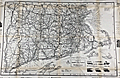 | Details | Bullard Company, The | 1916 |
| Huge road map of New England with early advertisements |
|
Bullard Company, The |
|
| 1916 |
| LOC:0 |
| $65.00 | Bullard-Company--The | Huge-road-map-of-New-England-with-early-advertisements | Large antique advertising-related 4' x 3' road map of south New England from the beginning of the age of automobile travel. Coverage extends from New York and Albany in the west to Cape Ann and Nantucket in the east. Includes Boston, Cape Cod, Martha's Vineyard, Block Island Sound, Rhode Island and Long Island Sound. Copyrighted 1916 by the Bullard Company, 44 Cornhill, Boston. A fine piece for the man-cave. (Yard-stick shown for size estimation, not included).
<br></br>
Inset advertising and related photographs and numerous closeup circular maps of key areas including: Fall River, Marblehead, New London, Concord, Plymouth, and Cape Cod. Overstamp reads: "Compliments of the Hotel Raymond. Fitchburg, Mass.".
<br></br>
Verso with advertisements and numerous tables of related information including distances and census data. Orginal envelope included. |
| 1218 |  | Details | Anonymous | 1889 |
| Boston and Gloucester Steamboat Company pass for 1888 |
|
Anonymous |
|
| 1889 |
| LOC:0 |
| $70.00 | Anonymous | Boston-and-Gloucester-Steamboat-Company-pass-for-1888 | An antique Boston and Gloucester Steamboat Company annual pass for the year 1888. On green card stock. Issued as number 116. Valid until January 1, 1889. Ship's wheel decoration with the date "1888".
<br></br>
Boston and Gloucester Steamboat company began year round service in 1870 and continued operating between Boston and Gloucester until 1926 when they ceased operations. Steamboats from the line included the "Ella Knight", "George Chaffee", "City of Gloucester", and the "Cape Ann" a steel-hulled propeller driven vessel of 171 feet in length.
<br></br>
Text on the verso of this antique pass with rules and stipulation for use of the pass. |
| 1144 |  | Details | George W. Walker Lithograph and Publishing Co | 1927 |
| Birds-eye View of Boston Harbor ca. 1927 |
|
George W. Walker Lithograph and Publishing Co |
|
| 1927 |
| LOC:0 |
| $295.00 | George-W--Walker-Lithograph-and-Publishing-Co | Birds-eye-View-of-Boston-Harbor-ca--1927 | Bird's-eye map of Boston Harbor and surrounding region to the east. This folding pocket map is Walker's earliest view of Boston with the new airport, constructed in 1923, that would eventually become Logan International Airport. At far upper right are the yards of the <b>Fore River Ship and Engine Company</b> with two vessels shown under construction.
<br></br>
Numerous steamers, sailboats, and sailing ships are shown underway in the waters offshore Boston, Massachusetts; Winthrop and Spectacle Island. This edition of Walker's map only shows steamer routes for the <b>Nantasket Beach Line Steamers</b> to Nantasket Beach and other points to the east.
<br></br>
The map extends from the coastal area of East and South Boston across the water to the main ship channel and the Boston Light. It locates Winthrop, Thompson's Island, Moon Island, Deer Island, Nahant, Green Island, the Brewster Islands, Strawberry Hill, Fort Warren, Hough's Neck and much more. Several key streets are identified within Boston: Atlantic Avenue, Freeport, Summer Street, Broadway, Dorchester Street, and State Street to name a few.
<br></br>
Copyright Walker Lithograph and Publishing Company, Boston.
<br></br>
Single-color chromolithograph. The bird's eye map folds into manilla board cover titled "Boston Harbor" in manuscript. Map is attached to the cover as issued. Cover apparently made by the seller whose stamp appears on the cover in red ink: "H.A. Shepard and Company. Stationers 50 - 52 Cornhill Boston". Price in manuscript: 15 cents. An unusual find! |
| 965 |  | Details | Blunt, E and G.W. | 1850 |
| Antique chart and plan of Cape Ann Harbor and Gloucester, Massachusetts |
|
Blunt, E and G.W. |
|
| 1850 |
| LOC:3 |
| $140.00 | Blunt--E-and-G-W- | Antique-chart-and-plan-of-Cape-Ann-Harbor-and-Gloucester--Massachusetts | Antebellum nautical chart of Gloucester ("Glocester"), MA. and Cape Ann Harbor from well known American publisher's of nautical charts and sailing directions, Edmund and George Blunt, and dated within to 1850. Noted features on this antique chart include <b>Ten Pound Island</b>, Ten Pound Island Ledge, Five Pound Island, Fort Point, Black Bess, Flat Point, and Norman's Woe Point with the nearby Norman's Woe Island. Includes numerous depth soundings, hazards, and aids to navigation as expected on a navigational chart. Shows a square fort at Fort Point near the Gloucester inner harbor but shows no structure in the location of Stage Point Fort.
<br></br>
The lighthouse on Ten Pound Island is shown near the mouth of the Gloucester inner harbor. The Ten Pound Island Light Station, originally a stone tower, was constructed on the island in 1821. That tower was replaced by the present cast-iron tower in 1881.
<br></br>
Topographic detail surrounding the harbor is shown through the use of light hachuring; numerous structures are shown scattered throughout that area.
<br></br>
The American Coast Pilot with other harbor charts, was published by Edmund and George W. Blunt from New York. The Blunts were the most prolific private publisher of navigational charts in the United States in the mid 19th century. |
| 847 |  | Details | Eldridge, George W. | 1917 |
| Antique chart of Block Island Sound between Montauk and Martha's Vineyard |
|
Eldridge, George W. |
|
| 1917 |
| LOC:1409 |
| $600.00 | Eldridge--George-W- | Antique-chart-of-Block-Island-Sound-between-Montauk-and-Martha-s-Vineyard | Antique nautical chart by Eldridge of Block Island Sound with portions of coastal New York, Connecticut, Maine, Massachusetts, and Rhode Island. Coverage on this maritime chart of New England includes Montauk Point on Long Island, Gardiners Island, Fishers Island, Block Island, Point Judith, Cuttyhunk Island, and Nashawena Island. Towns include: New London, Connecticut; Stonington, Maine; Newport, Rhode Island; and Westport Point, Massachusetts. Inset plan of Block Island Harbor at upper center. Near Newport, Rhode Island chart detail includes the Brenton Reef Light Ship, Fort Adams, Beavertail Point, Coasters Harbor Island, and Rose Island.
<br></br>
Newport, Rhode Island has a long association with sea trade, piracy, and naval history. During the colonial era the major financial activity in Rhode Island was the slave trade and Newport was at the center of that commerce. One of the first outward American acts of defiance against the British government took place on the north end of Goat Island in Newport harbor. In May, 1769 a mob of Rhode Islanders sank and burned the British revenue sloop HMS Liberty in retaliation for British seizures of American vessels.
<br></br>
This antique chart was produced under the name of George Washington Eldridge (1845-1914) who carried on the business of chart publishing after the death of his father George Eldridge in 1900. It was published by Wilfrid O. White of Boston, Massachusetts. White was Eldridge's son-in-law who continued to sell Eldridge's charts after his death until 1932.
<br></br>
Guthorn explains the attraction and value that Eldridge's charts held through the years for seafarers who depended on them: <div class="indenttextblock"> "They survived because of good design, simplicity, omission of extraneous shore topography, legible soundings, notes and the use of compass courses only ( Guthorn, Peter. United State Coastal Charts: 1783 - 1861. Exton, Pennsylvania. 1984. p. 12. )." </div> |
| 777 |  | Details | Eldridge, George W. | 1908 |
| Antique Chart of Gloucester Harbor and of Sandy Bay, Massachusetts |
|
Eldridge, George W. |
|
| 1908 |
| LOC:0 |
| $125.00 | Eldridge--George-W- | Antique-Chart-of-Gloucester-Harbor-and-of-Sandy-Bay--Massachusetts | Separately issued nautical charts of Gloucester Harbor and of Sandy Bay on the Cape Ann peninsula in Massachusetts. Includes the Massachusetts towns of Rockport and Gloucester. Other key features include Fresh Water Cove, Ten Pound Island, Southeast Harbor, Eastern Point, Thatcher's Island, Milk Island, Loblolly Cove, Whale Cove, Straitsmouth Island, The Rockport Granite Company, and Andrews Point. Much useful information including soundings, ranges, buoys, and bottom composition are presented in a clear graphic style that would have been appreciated by and helpful to mariners. For instance, these charts are printed with bold black coastal outlines that would have been easier to read under poor lighting conditions.
<br></br>
Attribution reads: 'AUTHORIZED and PUBLISHED By Geo. W. Eldridge, Vineyard Haven, Mass and 132 State St. Boston.' Price when issued was 30 cents. |
| 1219 |  | Details | Thaxter, Samuel and Son | 1890 |
| Samuel Thaxter and Son, Boston, trade card |
|
Thaxter, Samuel and Son |
|
| 1890 |
| LOC:0 |
| $325.00 | Thaxter--Samuel-and-Son | Samuel-Thaxter-and-Son--Boston--trade-card | Scarce trade card for the Boston, Massachusetts firm of <b>Samuel Thaxter and Son</b>. Samuel Thaxter was an importer and manufacturer of nautical and optical instruments. Thaxter was the publisher of Eldridge's charts and coast pilots, and an agent for U.S. Coast Survey charts and books. During this period, they operated from a store at 125 State Street, Boston.
<br></br>
Samuel Thaxter and Sons sold sextants, charts, compasses, binnacles, levels, and other nautical items that occasionally are found on the antiques market today.
<br></br>
Absence of red overprinting of a new address at bottom of card suggests a date between 1880 and 1900. Verso carries the following historical information about the firms' genesis:<br></br>
<div class="indenttextblock">
<b>One Hundred Years Under One Sign</b>
<br></br>
(From the Boston Evening Transcript, February 2d 1873.)
<br></br>
In 1779 William Williams carried on the Nautical-Instrument business in King, now State Street, having as a sign an image called "Admiral Vernon". In 1794 Samuel Thaxter, who married his niece, succeeded him and carried on the business in his own name thirty years. Then, taking his son a partner, the style of the firm was changed to S. THAXTER & SON, under which name it has continued the last fifty-one years at 125 State Street, corner Broad Street. Samuel Thaxter Cushing, grandson of S. Thaxter has been connected with the business thirty-eight years, and for the last thirty-three years, the only surviving partner. For all that time the "Admiral" with his quadrant has stood guard and stands guard now, on State Street, fit prototype of the smart little image displayed by Walter's uncle as chronicled in "Dombey & Son".</div> |
| 716 | 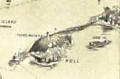 | Details | George W. Walker Lithograph and Publishing Co | 1907 |
| Boston Harbor and the North Shore |
|
George W. Walker Lithograph and Publishing Co |
|
| 1907 |
| LOC:0 |
| $260.00 | George-W--Walker-Lithograph-and-Publishing-Co | Boston-Harbor-and-the-North-Shore | Original antique birdseye view folding map of Boston Harbor by George Walker shows ferry routes, steamer routes and railroad lines between Boston and points both within Boston Harbor and to outlying towns. This fascinating old lithographed map differs from other birdseye-view maps we are aware of from this era because it includes Marblehead, Lynn, Salem and extends north-eastwards to Gloucester, Massachusetts. We can date the map with confidence because it clearly shows the Wonderland Amusement Park at Revere Beach which failed after five years, operating exclusively between 1906 and 1911. Wonderland, served by the Revere Beach and Lynn Railroad, was modeled along the lines of the World's Fairs of that era and included roller coasters, technological exhibits, theaters and a boardwalk.
<br></br>
Noted points of interest include Charlestown, Point of Pines, Magnolia, Baker's Island, Thompson's Island, "the Pumping Station", Dorchester Bay, Squantum, Norfolk Downs, Quincy Bay, Hough's Neck, Hingham Harbor, Winthrop, Beachmont, Great Head, Peddock's Island, Nantasket Beach, Port Allerton, the town of Hull with Fort Revere, George's Island with Fort Warren, Deer Island, Lovell's Island, Lynn, Swampscott, Thatcher's Island, Strawberry Hill, and many more. Captures several local lighthouses and aids to navigation including Boston Light, Long Island Light, Fawn Bar Beacon, Graves Light, and far out the bay - a whistling buoy.
<br></br>
Original lithograph by George W. Walker, lithographer of Boston in landscape format is in very good condition for a 105+ year old map. Was originally folded into a card cover but the front half has disappeared leaving the map attached to the back cover, as issued.
<br></br> |
| 652 |  | Details | George W. Walker Lithograph and Publishing Co | 1900 |
| New Bedford And Vicinity |
|
George W. Walker Lithograph and Publishing Co |
|
| 1900 |
| LOC:0 |
| $265.00 | George-W--Walker-Lithograph-and-Publishing-Co | New-Bedford-And-Vicinity | Early folding antique lithographed map of New Bedford, Massachusetts on thin paper. With cardboard cover, graced by views of whaling ships, attached to map as issued. Locations covered by the map include Buzzards Bay, the Elizabeth Islands, NW Martha's Vineyard, Westport, Dartmouth, Mattapoisett, Fall River, Acushnet, Naskatuckett Bay, Sippican Harbor, and West Falmouth, Massachusetts.
<br></br>
Published by H.S. Hutchinson and Company. Copyright 1892 by George W. Walker, lithographers. Precise publication date is unknown but must have been after 1899 as the map shows the New Bedford - Fairhaven Bridge that was completed in 1899. |
| 1005 | 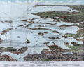 | Details | Finn, W.J. | 1917 |
| Birdseye View of Boston Harbor by Union News Co. |
|
Finn, W.J. |
|
| 1917 |
| LOC:200 |
| $240.00 | Finn--W-J- | Birdseye-View-of-Boston-Harbor-by-Union-News-Co- | Folding antique colored harbor excursion map from ca. 1917 of South Boston, Boston Harbor, Dorchester Bay, Quincy Bay, and Cape Cod Bay to Provincetown. This colorful survivor shows steamship routes to coastal towns and identifies many nearby islands.
<br></br>
This map could have been purchased by passengers aboard any steamboat plying the routes shown on the map including:
<div class="indenttextblock">
<ul style="list-style-type: circle;">
<li>To Europe</li>
<li>To Provincetown</li>
<li>To Plymouth</li>
<li>To Nantasket</li>
<li>To New York</li>
</ul>
</div>
Legend at bottom identifies numerous islands and other features as a sample below illustrates:
<div class="indenttextblock">
<ul style="list-style-type: circle;">
<li>Nixes Mate</li>
<li>Snake Island</li>
<li>Commonwealth Pier</li>
<li>Minots Light</li>
<li>Rowes Wharf</li>
</ul>
</div>
Without the advertisements sometimes found on the cover. Price is noted on the front as "10 cents". |
| 398 |  | Details | Freeman, Josiah | 1873 |
| Bark Ashore at Surfside |
|
Freeman, Josiah |
|
| 1873 |
| LOC:14 |
| $220.00 | Freeman--Josiah | Bark-Ashore-at-Surfside | Stereoview photo by Nantucket photographer Joseph Freeman of the sailing bark Minmaneuth aground near Miacomet Pond on Nantucket's south shore. The vessel was enroute from Rio de Janiero to Boston with 4000 bags of coffee when she came ashore. The Minmaneuth was lightened of its load and refloated. The grounding had a positive result in that it prompted construction of a lifesaving station at Surfside beach. The stereoview shows passengers, shaded by parasols, sitting atop bags of coffee as they wait for the rest of the cargo to be unloaded. <BR> </BR>
The Nantucket Historical Association describes Freeman as the first of three great 19th century Nantucket photographers including Henry Wyer and Harry Platt. Josiah Freeman first opened a shop with David Coffin on the island in 1864 and remained in business until retirement in 1892. ( Historic Nantucket, Vol 35, no. 2 (Oct. 1987), p. 12-14) |
| 289 |  | Details | Providence, Fall River and Newport Steamboat Co. | 1904 |
| Brochure- Providence , Fall River and Newport Steamboat Co |
|
Providence, Fall River and Newport Steamboat Co. |
|
| 1904 |
| LOC:0 |
| $165.00 | Providence--Fall-River-and-Newport-Steamboat-Co- | Brochure--Providence---Fall-River-and-Newport-Steamboat-Co | Scarce antique eight-page brochure and map for the Providence, Fall River and Newport Steamboat Company, 136 Dyer Street, Providence, Rhode Island. This small brochure, dated internally to 1904, contains time tables, descriptive information on each port and sightseeing tips and advertisements from local businesses and resorts.
<BR> </BR>
Contains a list of the eight steamers comprising the company's fleet and their passenger capacity:
<div class="indenttextblock">
<ul style="list-style-type: circle;">
<li>Mount Hope - 2000 persons</li>
<li>Warwick - 2000 persons</li>
<li>Richard Borden - 1500 persons</li>
<li>City of Newport - 1100 persons</li>
<li>Favorite - 1100 persons</li>
<li>What Cheer - 750 persons</li>
<li>Squantum - 850 persons</li>
<li>Baltimore - 500 persons</li>
</ul>
</div> |
| 210 |  | Details | Freeman, Josiah | 1880 |
| Stereoview- Nantucket. |
|
Freeman, Josiah |
|
| 1880 |
| LOC:14 |
| $100.00 | Freeman--Josiah | Stereoview--Nantucket- | Stereoview ca 1870-80 by Josiah Freeman of Nantucket. Scene looking out over Nantucket rooftops and gardens with a steam paddle wheeler rounding Brant Point Light House in the distance.<BR> </BR>
The Nantucket Historical Association describes Freeman as the first of three great 19th century Nantucket photographers including Henry Wyer and Harry Platt. Josiah Freeman first opened a shop with David Coffin on the island in 1864 and remained in business until retirement in 1892. ( Historic Nantucket, Vol 35, no. 2 (Oct. 1987), p. 12-14) |
| 5274 | 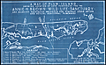 | Details | Pepin, A. L. | 1931 |
| Map Plum Island Annie H. Brown Wild Life Sanctuary |
|
Pepin, A. L. |
|
| 1931 |
| LOC:10 |
| $550.00 | Pepin--A--L- | Map-Plum-Island-Annie-H--Brown-Wild-Life-Sanctuary | An unrecorded cyanotype (blueprint) map of Plum Island from 1931 related to early conservation efforts on the Massachusetts coast. The map shows the location of land purchased for the Annie H. Brown Wildlife Sanctuary and several adjacent properties proposed for purchase.
<br></br>
Plum Island is a New England barrier island that lies on the coast of Massachusetts about two miles from Newburyport, Mass. Plum Island, 11 miles in length, is named for the beach plum shrubs that grow in the dunes. The North Point of the island is located at the mouth of Newburyport Harbor, where the Atlantic Ocean meets the Merrimack River.
<br></br>
Legend at bottom describes seven numbered tracts of land on the map:
<div class="indenttextblocksingle">
<ul style="list-style-type: circle;">
<li>300 acres - Annie H. Brown Wildlife Sanctuary.</li>
<li>110 acres - Land of Knobbs Beach Associates.</li>
<li>225 acres - Land of Woodworth.</li>
<li>90 acres - Land of Stafford.</li>
<li>75 acres Land of Clement.</li>
<li>400 acres - Land of Bar Island realty Company.</li>
<li>3 acres - Land of Small.</li>
</ul>
</div>
Annie Hamilton Brown, a resident of Stoneham, willed a sum of between $15,000 and $25,000 to the Federation of the Bird Clubs of New England in 1929. Working with the Massachusetts Audubon Society, the federation was able to purchase most of the southern end of Plum Island for a wildlife sanctuary. In 1943, the Audubon Society sold the 1,600 acre sanctuary to the Federal Government who merged the land into the Parker River National Wildlife Refuge. This item includes the original fund-raising transmittal letter and return envelope from the Federation of the Bird Clubs of New England, Inc. Laurance B. Fletcher, Secretary; Boston, Massachusetts.
<br></br> |