| | Thumbnail | | Creator | Date | Title / Author / Date / Location | Price | | | Description |
| 605 | 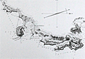 | Details | Depot de la Marine | 1823 |
| Plan du Golfe de Santa Manza |
|
Depot de la Marine |
|
| 1823 |
| LOC:66 |
| $500.00 | Depot-de-la-Marine | Plan-du-Golfe-de--Santa-Manza | Lovely antique chart of the Gulf of Santa Manza, on the southeast coast of Corsica ( Corse ), France near the town of Bonifacio with numerous soundings and coastal topographic details. Beautifully executed and finely detailed engraving in near-perfect condition. Noted features include: Port de Santa Manza, Iles de Porraja, Cap Capicciolo, Cap Blanc, Cap Rondinara, Port de la Rondinara, Calanque de Carlo Anto, Tour de Sponsaglia, Mt. Carpice, amd Porto Nuovo. At top, and extending the full width is a beautifully engraved view of the coastline that includes all the points above and many more.<br></br>
This large, original copperplate nautical chart was issued by the French Depot de la Marine in 1823 and bears the circular stamp of that agency. Engraved by Ambroise Tardieu. With the circular stamp of three fleur-de-lis surrounding an anchor, from the Depot General de la Marine. |