| | Thumbnail | | Creator | Date | Title / Author / Date / Location | Price | | | Description |
| 949 | 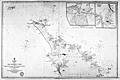 | Details | British Admiralty Hydrographical Office | 1857 |
| Antique Chart of the Northern Coast of New Zealand from Hokianga to Tutukaka |
|
British Admiralty Hydrographical Office |
|
| 1857 |
| LOC:59 |
| $1,500.00 | British-Admiralty-Hydrographical-Office | Antique-Chart-of-the-Northern-Coast-of-New-Zealand-from-Hokianga-to-Tutukaka | Scarce antique hydrographic chart of the northern coastline of <b>New Zealand</b> from the Hokianga Harbour to Tutukaka, in the province of Auckland. Among the earliest available artifacts from the first full hydrographic survey of New Zealand during 1849-1855. At upper left corner are the uninhabited Three-Kings Islands about 35 miles northwest of Cape Reinga, the northernmost point of New Zealand's North Island. With large insets of Parenga Renga Harbour and Ohora River and Bay.
<br></br>
Based on surveys of <b>Captain J. L. Stokes</b> and Commander R. Drury of the HMS Acheron and the Pandora respectively. Among his many accomplishments, Stokes served as assistant surveyor aboard the <b>HMS Beagle</b> during its well-known voyage around the world with Charles Darwin in 1833-36. Hooker's brief biography of Stokes includes a portrait and this entry:
<div class="indenttextblock"> "Stokes, John Lort (1812-86) - Royal Navy officer and hydrographer, was chosen by Beaufort, the British Hydrographer for the 'Great New Zealand Survey.' Stokes had joined the navy as a ‘volunteer first class’ in 1824 and by 1843, he was an experienced surveyor with the rank of commander. In 1846, he was promoted to captain and in the following year was given command of HMS Acheron. Between 1848 and 1855, Stokes surveyed extensively in New Zealand waters. With Drury’s surveys they were the most complete investigations carried out to that time. Over forty-five New Zealand charts were published in the years following Stokes’ and Drury’s surveys. Some of Stokes' data were also incorporated in maps published by Arrowsmith." (Hooker, Brian. Dictionary of New Zealand Map-Makers.<a href="http://zeehaen.tripod.com/dictionary_map_m/dictionary_part_c_bh.htm " target="_blank">Internet</a>)</div>
</br>
Contains a seller's circular black ink overstamp from "Reading and Wellbank, Chart and Nautical Booksellers, 366 George Street." Number 2525. |
| 4757 | 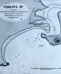 | Details | British Admiralty Hydrographical Office | 1873 |
| Antique Chart of New Zealand from Otago to the Mataura River and Ruapuke Island |
|
British Admiralty Hydrographical Office |
|
| 1873 |
| LOC:59 |
| $1,100.00 | British-Admiralty-Hydrographical-Office | Antique-Chart-of-New-Zealand-from-Otago-to-the-Mataura-River-and-Ruapuke-Island | Two scarce antique charts of New Zealand on one sheet: 1) Middle Island, Otago to Mataura River (with large scale insets of Waikawa Harbor and of Catlin River), and 2) Foveaux Strait, Ruapuke Island.
<br></br>
Based on surveys of <b>Captain J. L. Stokes</b> and officers of the HMS Acheron during 1849-1851. Among his many accomplishments, Stokes served as assistant surveyor aboard the <b>HMS Beagle</b> during its well-known voyage around the world with Charles Darwin in 1833-36. Hooker's brief biography of Stokes includes a portrait and this entry:
<div class="indenttextblock"> "Stokes, John Lort (1812-86) - Royal Navy officer and hydrographer, was chosen by Beaufort, the British Hydrographer for the 'Great New Zealand Survey.' Stokes had joined the navy as a ‘volunteer first class’ in 1824 and by 1843, he was an experienced surveyor with the rank of commander. In 1846, he was promoted to captain and in the following year was given command of HMS Acheron. Between 1848 and 1855, Stokes surveyed extensively in New Zealand waters. With Drury’s surveys they were the most complete investigations carried out to that time. Over forty-five New Zealand charts were published in the years following Stokes’ and Drury’s surveys. Some of Stokes' data were also incorporated in maps published by Arrowsmith." (Hooker, Brian. Dictionary of New Zealand Map-Makers.<a href="http://zeehaen.tripod.com/dictionary_map_m/dictionary_part_c_bh.htm " target="_blank">Internet</a>)</div> |
| 953 | 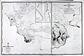 | Details | British Admiralty Hydrographical Office | 1875 |
| Antique Chart of Bluff Harbor and Invercargill, New Zealand |
|
British Admiralty Hydrographical Office |
|
| 1875 |
| LOC:59 |
| $1,375.00 | British-Admiralty-Hydrographical-Office | Antique-Chart-of-Bluff-Harbor-and-Invercargill---New-Zealand | Large British Hydrographic charts of <b>Bluff Harbor</b> on the southern coast of South Island, <b>New Zealand</b>. Located across the Foveaux Strait from Bluff is Stewart Island (not shown). Bluff is one of the oldest areas on New Zealand where Europeans established a presence. The first European settlers arrived around 1823. A second, enlarged scale chart is at right of "Entrance of Awarua or Bluff Harbour."
<br></br>
With an inset chart "Continuation of New River to <b>Invercargill</b> / surveyed by Mr J.T. Thomson, 1856." Invercargill is the southernmost and westernmost sizeable city in New Zealand, and among cities with a population of over 50,000 is the 5th southernmost city in the world. (<a href="https://en.wikipedia.org/wiki/Southernmost_settlements " target="_blank">Internet</a>)
<br></br>
The chart denotes the location of Maori settlements including: "Old village of Te Whero"; "Owi Village"; "Omawi Village"; and a "Freshwater Spot".
<b></b>
At upper right, sailing directions for Bluff Harbor from Mr. Thomson, Harbor Master in 1865 includes instructions for boarding a pilot:
<div class="indenttextblock"> "Vessels from the Eastward, taking the passage between Dog Island and the sands, should give the island a half mile berth and steer about West for Look-out Point till Starling Pt. bears North, then steer in to pass about 1 1/2 cables length [ a cable length is about 100 fathoms or 600 feet] off Starling Pt. leaving the red buoys on the starboard hand and when abreast of it the pilot boat will be seen.
</div>
</br>
Manuscript marginal notations (sailing directions) in French and two manuscript additions of bouys to the chart suggest that this chart was actually used for navigation in that area.
<br></br>
Based on surveys of <b>Captain J. L. Stokes</b> of the HMS Acheron. Stokes served as assistant surveyor aboard the <b>HMS Beagle</b> during its well-known voyage around the world with Charles Darwin in 1833-36. |
| 1329 | 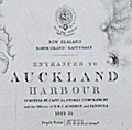 | Details | British Admiralty Hydrographical Office | 1876 |
| Antique chart of Auckland Harbor, New Zealand |
|
British Admiralty Hydrographical Office |
|
| 1876 |
| LOC:0 |
| $0.00 | British-Admiralty-Hydrographical-Office | Antique-chart-of-Auckland-Harbor--New-Zealand | SOLD
<br></br>
Scarce antique British nautical chart of the entrances to Auckland Harbour, New Zealand based on the <b>first complete hydrographic survey of New Zealand waters</b> which was conducted by Captain J.L. Stokes, Commander B. Drury and the Officers of H.M.S. Acheron and Pandora 1849-1855. This edition contains corrections up to 1876. Chart number 1896.
<br></br>
This detailed chart of Auckland, New Zealand is based on surveys of <b>Captain J. L. Stokes</b> and Commander R. Drury of the HMS Acheron and the Pandora respectively. Among his many accomplishments, Stokes served as assistant surveyor aboard the <b>HMS Beagle</b> during its well-known voyage around the world with Charles Darwin in 1833-36. Hooker's brief biography of Stokes includes a portrait and this entry:
<div class="indenttextblock"> "Stokes, John Lort (1812-86) - Royal Navy officer and hydrographer, was chosen by Beaufort, the British Hydrographer for the 'Great New Zealand Survey.' Stokes had joined the navy as a ‘volunteer first class’ in 1824 and by 1843, he was an experienced surveyor with the rank of commander. In 1846, he was promoted to captain and in the following year was given command of HMS Acheron. Between 1848 and 1855, Stokes surveyed extensively in New Zealand waters. With Drury’s surveys they were the most complete investigations carried out to that time. Over forty-five New Zealand charts were published in the years following Stokes’ and Drury’s surveys. Some of Stokes' data were also incorporated in maps published by Arrowsmith." (Hooker, Brian. Dictionary of New Zealand Map-Makers.<a href="http://zeehaen.tripod.com/dictionary_map_m/dictionary_part_c_bh.htm " target="_blank">Internet</a>)</div>
</BR>
See also: ( Hargreaves, R.P. "Nineteenth Century Hydrographic Charts: A Preliminary Checklist." <a href="https://evols.library.manoa.hawaii.edu/bitstream/10524/55278/1/v27n07_1964_Hargreaves.pdf" target="_blank">Online</a>.) |
| 7876 | 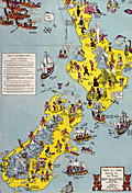 | Details | Paterson, Alan Stuart | 1940 |
| Pictorial Historical Map of New Zealand |
|
Paterson, Alan Stuart |
|
| 1940 |
| LOC:141 |
| $0.00 | Paterson--Alan-Stuart | Pictorial-Historical-Map-of-New-Zealand | SOLD<br><br>Scarce cartoonish pictorial map of New Zealand ca. 1940 primarily focused on historical events related to white settlers, but with a lighthearted, comical touch. Apparently scarce; only three examples found in WorldCat, all in New Zealand institutions.
<br><br>
Drawn by Alan Stuart Patterson. Published by A.H. Reed and A.W. Reed. Dunedin, NZ. by permission of the Lands and Survey Department.
<br><br>
Paterson's clever map shows numerous historical events in New Zealand including:
<div class="indenttextblocksingle">
<ul style="list-style-type: circle;"></li>
<li>The Great Migration of the Maoris from Hawaiki to Aotearoa</li>
<li>Route of explorer Abel Tasman.</li>
<li>Treaty of Waitangi in 1840.</li>
<li>First arrival of tourists at Rotorua</li>
<li>Arrival of the 'Tory' at Port Nicholson in 1839.</li>
<li>Discovery of the succulence of Bluff Oysters</li>
</ul>
</div>
In the late 18th and early 19th centuries, European explorers, primarily from Britain, began to visit and settle in New Zealand. The first known European to sight New Zealand was Dutch navigator Abel Tasman in 1642, but it was not until the voyages of British explorer James Cook in the late 1760s and 1770s that the islands were mapped and more extensively explored. Following Cook's journeys, whalers, sealers, and traders started to visit New Zealand, establishing contact with the indigenous Māori people.
<br><br>
The early interactions between European settlers and Māori were characterized by a mix of cooperation, trade, and conflict. Many Māori initially welcomed the newcomers, as they brought new technologies, such as muskets and metal tools, which the Māori quickly adapted for their own purposes. However, the increasing European presence also led to disputes over land, resources, and cultural misunderstandings. The introduction of European diseases, to which the Māori had no immunity, also had a devastating impact on the indigenous population.
<br><br> |
| 6426 | 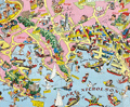 | Details | Pictorial Publications Limited | 1959 |
| Pictorial map of Wellington, New Zealand |
|
Pictorial Publications Limited |
|
| 1959 |
| LOC:90 |
| $0.00 | Pictorial-Publications-Limited | Pictorial-map-of-Wellington--New-Zealand | SOLD<br><br>Apparently quite scarce original pictorial birds-eye view map of Wellington, New Zealand. The artist is unknown but the map was copyrighted and published ca. 1959 by Pictorial Publications Limited, Hastings, New Zealand. A fun, comical map of Wellington featuring local activities such as water-skiing, fishing, boating, swimming, and sailing. Small manuscript notation "Evening Post" on recto pointing to a building on Willis Street, downtown.
<br><br>
The map is surrounded with color photographic images of local Wellington, NZ attractions including:
<div class="indenttextblocksingle">
<ul style="list-style-type: circle;"></li>
<li>Oriental Bay</li>
<li>Massey Memorial</li>
<li>Wellington from Tinakori Heights</li>
<li>Riddiford baths</li>
<li>Carillon</li>
<li>Parliament buildings</li>
</ul></div>
Text on verso with historical and tourist-related details. Manuscript dedication on verso. |
| 5432 | 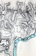 | Details | Gamble, D.J. | 1973 |
| Map of Action on Koheroa Ridges Maori War New Zealand |
|
Gamble, D.J. |
|
| 1973 |
| LOC:78 |
| $0.00 | Gamble--D-J- | Map-of-Action-on-Koheroa-Ridges-Maori-War-New-Zealand | SOLD<br></br> Map related to the New Zealand Wars. In response to Maori attacks on local settlers on the 12th of July 1863, Lieutenant-General Cameron and 400 soldiers occupied the high ground on the Koheroa Range in order to control navigation along the Waikato River. The map shows the location of Maori entrenchments, British field works, the track along the narrow ridge tops, and the site of battle on July 17, 1863.
<br></br>
An illustration from <strong>Bush Fighting: Illustrated by Remarkable Actions and Incidents of the Maori War in New Zealand</strong> by Major-General Sir James Edward Alexander.
<br></br>
Published by SAMPSON LOW, MARSTON, LOW AND SEARLE.: London. 1873. Lithographed by Edward Weller, Red Lion Square. Verso is blank. |